Local events in Lake Township, Stark County
5 events in the next 90 days from 1 public calendar. All local events in Lake Township, Stark County
Checked October 20; the events page is refreshed daily.
How Lake Township, Stark County began
Lake Township became an independent civil township in 1816, having previously existed as a survey township within Plain Township (formed 1806) and Green Township. Its name reflects the lakes that mark the area, most notably Congress Lake in the township's south. Lake Township grew from 588 residents in 1820 to become one of Stark County's more populous urban townships, with 30,324 residents recorded in the 2020 census, and its population jumped 39.5 percent in a single decade between 1960 and 1970 amid postwar suburban growth.
Incorporated independent township 1816.
Where the name comes from
No source consulted gives an explicit naming account, but the name reflects the township's lakes, most notably Congress Lake in its southern part.
Before the town
No Native American village, mound, or treaty site specific to Lake Township is documented in the sources consulted. The township lies in the area of Stark County ceded by the Treaty of Greenville (1795).
Nations recorded here: Lenape (Delaware).
Timeline
- — The land that becomes Lake Township is first organized as a survey township within Plain Township.
- — Lake Township becomes an independent civil township, separating from Plain Township.
- — The township's population is recorded at 588 residents.
- — Population reaches 2,162, a 267 percent increase over 1820.
- — North Canton (then New Berlin) is founded in neighboring Plain Township, beginning the industrial growth that eventually draws suburban development into Lake Township as well.
- — Lake Township's population jumps 39.5 percent to 13,053 residents amid postwar suburbanization.
- — The U.S. Census records 30,324 residents in Lake Township.
Stories
From a survey line inside Plain Township to its own suburb
Lake Township did not start out as its own place. Before 1816 the land was simply a survey township nested inside the much larger Plain Township, itself organized only in 1806. When Lake Township finally split off to govern itself, it remained thin farm country for more than a century, its population climbing only into the low thousands. The postwar decades changed that abruptly: between 1960 and 1970 alone the township's population jumped nearly 40 percent, part of the same suburban wave that was filling in the country around North Canton and Canton with subdivisions built for the Hoover Company's and Timken's workforces. Congress Lake, in the township's south, gives the area its name and remains a recreational landmark amid what is now a fully built-out Stark County suburb.
Photographs
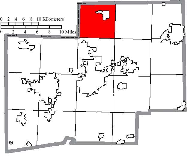
Photo: Ruhrfisch and Nyttend, CC BY-SA 3.0 · Wikimedia Commons
Local history sources: en.wikipedia.org · en.wikipedia.org · en.wikipedia.org · commons.wikimedia.org
Historic places
1 place in Lake Township, Stark County on the National Register of Historic Places. Press a pin or a name for its whole record.
-
Miller, John, HouseBuilding · Greentown · listed 1994
- Address
- 9677 Cleveland Ave. NW.
- Where
- Greentown, Stark County · ZIP 44630
- What it is
- Building
- Listed on the National Register
- 1994
- NRIS reference number
- 94000775
- Coordinates
- 40.92697, -81.40294
National Register file (NPS) ↗ Search Wikipedia ↗ Street map and directions ↗ On the Cracked Buckeye map
Source: National Park Service, National Register of Historic Places point file. The listing year is shown where NPS's certification date agrees with the listing's reference number. Listing recognizes significance; it does not restrict a private owner.
Water
Primary source: ten wells in a sand-and-gravel aquifer in the Tuscarawas Valley in and near Massillon. Secondary source: water purchased from the City of North Canton (PWSID OH7604312), used to supplement supply to the City of Green and portions of the Stark County system. The water here
- North Canton City33% of residentsWells in buried valley & Massillon Sandstone aquifers
- Stark County Water District32% of residentsWells in Tuscarawas Valley sand & gravel aquifer
- Aqua Ohio - Massillon28% of residentsWells in Tuscarawas Valley sand & gravel aquifer
- Canton Public Water System6% of residentsGlacial sand-and-gravel aquifer (3 well fields)
- Akron City2% of residentsLake Rockwell (Cuyahoga River impoundment)
- Aqua Ohio - Beechcrest0% of residentsBuried valley/sandstone aquifer wells (12 county wells)
- Fairlane Water Co.0% of residentsGroundwater wells (2 wells)
- Portage County Wr - Rivermoor0% of residentsGroundwater wells (2 wells)
- Fox Run Estates0% of residentsGroundwater wells (2 wells)
- Avon Mobile Home Park0% of residentsGroundwater wells (1 wells)
Hospitals, fire stations and more
Inside Lake Township, Stark County's boundary: 1 nursing home, 3 fire and EMS stations, 1 public school, 1 private school, 2 museums, 1 shale or injection well, 3 Superfund sites, 5 Toxics Release Inventory facilities and 10 spill cases. Press a pin or a name for its whole record and its source.
Nursing homes (1)
-
Altercare of Hartville Ctr For5 of 5 stars · Hartville
- Address
- 1420 Smith Kramer Road, Hartville, OH 44632
- Certified beds
- 95
- Residents on an average day
- 78
- Medicare overall rating
- 5 of 5 stars
- Health inspections
- 4 of 5 stars
- Staffing
- 2 of 5 stars
- Quality measures
- 5 of 5 stars
- Penalties since 2023
- none
- Ownership
- For profit - Corporation
- Chain
- ALTERCARE
- Takes
- Medicare and Medicaid
- Phone
- (330) 877-2666
- Medicare ID
- 366027
Medicare Care Compare ↗ CMS nursing home data (source) ↗ Street map and directions ↗
Source: CMS Care Compare nursing home provider and penalties files; Medicare star ratings run 1 to 5.
Fire and EMS stations (3)
-
Greentown Volunteer Fire DepartmentUniontown
- Address
- 10100 Cleveland Avenue Northwest, Uniontown, OH 44685
- Coordinates
- 40.93367, -81.40190
USGS National Map structures (source) ↗ Street map and directions ↗
-
Hartville Fire Department Station 2Hartville
- Address
- 2955 Nimishillen Church Street Northeast, Hartville, OH 44721
- Coordinates
- 40.92641, -81.32362
USGS National Map structures (source) ↗ Street map and directions ↗
-
Uniontown Fire DepartmentUniontown
- Address
- 13055 Oakwood Avenue Northwest, Uniontown, OH 44685
- Coordinates
- 40.97684, -81.40446
USGS National Map structures (source) ↗ Street map and directions ↗
Source: USGS National Map structures (most Ohio records last updated 2019 to 2022), checked against the Columbus and Cleveland station lists. The department that answers a call is set by jurisdiction and mutual aid, not by distance.
Public schools (1)
-
Lake Primary School4 of 5 stars · Uniontown
- Address
- 13244 Cleveland Ave NW, Uniontown, OH 44685
- School district
- Lake Local School District
- Kind (NCES)
- Regular School
- Students, 2023-24
- 435
- Teachers (full-time equivalent)
- 28.53
- Report card, 2025-26
- 4 of 5 stars
- Ohio building IRN
- 037879
- NCES school ID
- 390498603723
NCES school record ↗ Ohio School Report Card ↗ Street map and directions ↗
Source: NCES EDGE public school locations 2024-25 and Common Core of Data 2023-24 (type, students, teachers); Ohio School Report Cards 2025-26 (Department of Education and Workforce), matched by name within the district.
Private schools (1)
-
Lake Center Christian SchoolPrivate, conservative Christian · Hartville
- Address
- 12893 Kaufman Ave Nw, Hartville, OH 44632
- Kind
- conservative Christian
- Students, 2023-24
- 872
- Teachers (full-time equivalent)
- 80.3
- Students per teacher
- 10.8593
- Phone
- (330) 877-2049
- NCES private school ID
- 01063784
Source: NCES Private School Survey 2023-24.
Museums, historical societies, gardens and zoos (2)
-
Invent NowScience or technology museum · North Canton
- What it is
- Science or technology museum
- City
- North Canton
- Coordinates
- 40.91742, -81.41333
Search Wikipedia ↗ IMLS Museum Data Files (source) ↗ Street map and directions ↗
The museum list is IMLS's 2018 file; a museum may have closed or moved since.
-
Museum Of MotivationMuseum · Uniontown
- What it is
- Museum
- City
- Uniontown
- Coordinates
- 40.96172, -81.40923
Search Wikipedia ↗ IMLS Museum Data Files (source) ↗ Street map and directions ↗
The museum list is IMLS's 2018 file; a museum may have closed or moved since.
Source: IMLS Museum Data Files, 2018.
Shale and injection wells (1)
-
Alloway {Swiw#11} 1-D InjectionInjection well (Class II)
- What it is
- Injection well (Class II)
- Operator
- Riverside Petroleum & Prod.
- County
- Stark County
- API well number
- 34151211790000
- Coordinates
- 40.93073, -81.40449
ODNR oil and gas wells (source) ↗ Street map and directions ↗
Source: ODNR Division of Oil and Gas Resources well inventory (September 2026): drilled Utica, Marcellus and horizontal wells and Class II injection wells not plugged. Older vertical wells are on the full map.
Superfund sites (3)
-
Bishopsgate PropertiesSuperfund program · Uniontown
- Address
- 12777 Mogadore Avenue Nw, Uniontown, OH 44685
- County
- Stark County
- Status
- Superfund program site, not on the National Priorities List
- EPA program ID
- OHN000520489
- EPA registry ID
- 110071102294
EPA facility record ↗ EPA Facility Registry Service (source) ↗ Street map and directions ↗
-
Greentown DumpSuperfund program · Uniontown
- Address
- 2365 State St., Uniontown, OH 44709
- County
- Stark County
- Status
- Superfund program site, not on the National Priorities List
- EPA program ID
- OH0002342509
- EPA registry ID
- 110009303841
EPA facility record ↗ EPA Facility Registry Service (source) ↗ Street map and directions ↗
-
Industrial Excess Landfill NPLSuperfund, NPL · Uniontown
- Address
- 4Mi S Inter 619 & Cleveland Avenue, Uniontown, OH 44685
- County
- Stark County
- Status
- On the National Priorities List
- EPA program ID
- OHD000377911
- EPA registry ID
- 110071101755
EPA facility record ↗ EPA Facility Registry Service (source) ↗ Street map and directions ↗
Source: EPA Facility Registry Service, Superfund (SEMS) and National Priorities List sites. Many program sites were assessed and needed no cleanup.
Facilities reporting toxic releases (5)
-
Ajax Tocco Magnethermic - N. Canton (1576171949)Toxics Release Inventory · North Canton
- Address
- 8984 Meridian Circle Nw, North Canton, OH 44720
- County
- Stark County
- Status
- Reports to the Toxics Release Inventory (active)
- EPA program ID
- 44720JXTCC8984M
- EPA registry ID
- 110031019573
EPA facility record ↗ EPA Facility Registry Service (source) ↗ Street map and directions ↗
-
Hendrickson Usa LlcToxics Release Inventory · North Canton
- Address
- 9260 Pleasantwood Ave Nw, North Canton, OH 44720
- County
- Stark County
- Status
- Reports to the Toxics Release Inventory (***unchanged***)
- EPA program ID
- 4472WHNDRC926PL
- EPA registry ID
- 110004722346
EPA facility record ↗ EPA Facility Registry Service (source) ↗ Street map and directions ↗
-
Powell Electrical Systems IncToxics Release Inventory · North Canton
- Address
- 8967 Pleasantwood Ave Nw, North Canton, OH 44720
- County
- Stark County
- Status
- Reports to the Toxics Release Inventory (open)
- EPA program ID
- 44720SCNDS8967P
- EPA registry ID
- 110000391219
EPA facility record ↗ EPA Facility Registry Service (source) ↗ Street map and directions ↗
-
Specialty ProcessingToxics Release Inventory · Uniontown
- Address
- 1795 Saint Ives Cir Nw, Uniontown, OH 44685
- County
- Stark County
- Status
- Reports to the Toxics Release Inventory
- EPA program ID
- TRI_OFFSITE_1947
- EPA registry ID
- 110070691993
EPA facility record ↗ EPA Facility Registry Service (source) ↗ Street map and directions ↗
-
Stolle Machinery - RediconToxics Release Inventory · North Canton
- Address
- 9073 Pleasantwood Ave Nw, North Canton, OH 44720
- County
- Stark County
- Status
- Reports to the Toxics Release Inventory
- EPA program ID
- 4472WSTLLM973PL
- EPA registry ID
- 110004738838
EPA facility record ↗ EPA Facility Registry Service (source) ↗ Street map and directions ↗
Source: EPA Facility Registry Service, Toxics Release Inventory reporters. Reporting a release is required of large users of listed chemicals; it is not by itself a violation.
Spills reported since 2021 (10)
-
Material Black2025-11-07 · Lake Twp
- Reported
- 2025-11-07
- What spilled
- Material Black
- Where
- Lake Twp, Stark County
- Ohio EPA district office
- NEDO
- Ohio EPA case number
- 2511EPA0001819
Ohio EPA spill reports (source) ↗ Street map and directions ↗
-
Oil Hydraulic Fluid(S)2025-09-06 · Lake Twp
- Reported
- 2025-09-06
- What spilled
- Oil Hydraulic Fluid(S)
- Where
- Lake Twp, Stark County
- Ohio EPA district office
- NEDO
- Ohio EPA case number
- 2509EPA0001506
Ohio EPA spill reports (source) ↗ Street map and directions ↗
-
Oil Hydraulic Fluid(S)2025-06-16 · Lake Twp
- Reported
- 2025-06-16
- What spilled
- Oil Hydraulic Fluid(S); Fuel Diesel / Diesel Fuel (Vehicle On Or Off Road)
- Largest amount reported
- 100 gallons
- Where
- Lake Twp, Stark County
- Ohio EPA district office
- NEDO
- Ohio EPA case number
- 2506EPA0000981
Ohio EPA spill reports (source) ↗ Street map and directions ↗
-
Fuel Diesel / Diesel Fuel (Vehicle On Or Off Road)2024-09-13 · Lake Twp
- Reported
- 2024-09-13
- What spilled
- Fuel Diesel / Diesel Fuel (Vehicle On Or Off Road)
- Largest amount reported
- 20 gallons
- Where
- Lake Twp, Stark County
- Ohio EPA district office
- NEDO
- Ohio EPA case number
- 2409EPA0001573
Ohio EPA spill reports (source) ↗ Street map and directions ↗
-
Manure Nos (Not Specified) Reached water2023-10-25 · Lake Twp
- Reported
- 2023-10-25
- What spilled
- Manure Nos (Not Specified)
- Reached a waterway
- 76 - Congress Lake Outlet
- Where
- Lake Twp, Stark County
- Ohio EPA district office
- NEDO
- Ohio EPA case number
- 2310EPA0001826
Ohio EPA spill reports (source) ↗ Street map and directions ↗
-
Oil Crude2023-04-20 · Lake Twp
- Reported
- 2023-04-20
- What spilled
- Oil Crude
- Where
- Lake Twp, Stark County
- Ohio EPA district office
- NEDO
- Ohio EPA case number
- 2304EPA0000634
Ohio EPA spill reports (source) ↗ Street map and directions ↗
-
Material Green2022-05-16 · Lake Twp
- Reported
- 2022-05-16
- What spilled
- Material Green
- Where
- Lake Twp, Stark County
- Ohio EPA district office
- NEDO
- Ohio EPA case number
- 2205EPA0000716
Ohio EPA spill reports (source) ↗ Street map and directions ↗
-
Drum(S)2021-09-02 · Lake Twp
- Reported
- 2021-09-02
- What spilled
- Drum(S)
- Where
- Lake Twp, Stark County
- Ohio EPA district office
- NEDO
- Ohio EPA case number
- 2109EPA0001397
Ohio EPA spill reports (source) ↗ Street map and directions ↗
-
Fuel Diesel / Diesel Fuel (Vehicle On Or Off Road) Reached water2021-05-01 · Lake Twp
- Reported
- 2021-05-01
- What spilled
- Fuel Diesel / Diesel Fuel (Vehicle On Or Off Road)
- Largest amount reported
- 10 gallons
- Reached a waterway
- 76 - Tuscarawas River
- Where
- Lake Twp, Stark County
- Ohio EPA district office
- NEDO
- Ohio EPA case number
- 2105EPA0000600
Ohio EPA spill reports (source) ↗ Street map and directions ↗
-
Oil Petroleum Not Otherwise Specified (Nos)2026-07-24 · Lake Twp
- Reported
- 2026-07-24
- What spilled
- Oil Petroleum Not Otherwise Specified (Nos)
- Where
- Lake Twp, Stark County
- Ohio EPA district office
- NEDO
- Ohio EPA case number
- 2607EPA0001353
Ohio EPA spill reports (source) ↗ Street map and directions ↗
Source: Ohio EPA emergency response spill reports, 2021 to September 2026, one point per case where Ohio EPA placed it. A report is what the caller or responder recorded; amounts are often blank or estimated.
Its ZIP codes
Each ZIP code that touches Lake Township, Stark County, with the share of its residents who live here and the same headline figures as the ZIP page.
The county
Summit County: 34 ZIP codes, 30 cities, villages and townships, 544,541 people.
Nearby places
Quick answers
What county is Lake Township, Ohio in?
Lake Township, Stark County is a township in Summit County, Ohio, with 26,995 residents.
When was Lake Township, Ohio founded?
Lake Township, Stark County was incorporated independent township 1816. Source
What ZIP code is Lake Township, Ohio?
Lake Township, Stark County is served by ZIP codes 44630, 44685, 44632, 44720, 44721 and 44260; 44630 holds the largest share of its residents.
Where does Lake Township, Ohio get its water?
The main water source for Lake Township, Stark County (North Canton City): Primary source: ten wells in a sand-and-gravel aquifer in the Tuscarawas Valley in and near Massillon. Secondary source: water purchased from the City of North Canton (PWSID OH7604312), used to supplement supply to the City of Green and portions of the Stark County system.
Cite this page
Cite this page as:
Cracked Buckeye, "Lake Township, Stark County", https://crackedbuckeye.com/place/lake-township-stark-county/, built 2026-10-31, accessed [date].
How to cite · Report a correction · Built 2026-10-31
