Local events in Marlboro Township, Stark County
Nothing is posted for Marlboro Township itself yet; here is what is on within 10 miles. All local events in Marlboro Township, Stark County
-
CancelledMagic: The Gathering Meet-Up
Know a calendar we should watch? Send the link
Checked October 20; the events page is refreshed daily.
How Marlboro Township, Stark County began
Marlboro Township, historically Marlborough, in northeastern Stark County, was settled slowly because about a quarter of it was swamp and marsh; Mahlon Wileman, a Quaker, wintered alone in a cabin on Section 1 in 1805-06 and is counted its first permanent settler. About a third of the early settlers were Quakers, whose meetinghouse east of Marlborough village predates 1820, and the 1881 county history credits them with helping scores of fugitive slaves north. The township was set off from Lexington in 1821, New Baltimore and Marlborough were laid out as villages, and Marlborough later had a foundry building steam engines and, from 1874, a fruit cannery. An 1833 gazetteer counted three stores, a tannery and four sawmills; the township had 4,277 residents in 2020.
Settled 1805 (Mahlon Wileman, autumn), platted November 1827 (village of Marlborough), incorporated June 1821 (township ordered; election August 25, 1821), by Mahlon Wileman (first settler); Moses Pennock, William Pennock, Samuel Ellison and Denny Johnson (village plat).
Where the name comes from
No source consulted gives a specific naming account for Marlboro (historically spelled Marlborough) Township; it is one of only two townships of that name in Ohio, the other in Delaware County.
Before the town
The 1881 county history records that when Mahlon Wileman went back to Columbiana County for supplies in 1805-06, he left his tools in the care of an Indian chief whose band was camped on Deer Creek in the township, and found everything returned in good order. It names no nation for the band, and no mound or village site is recorded. Land east of the Tuscarawas River had its Native title extinguished by the Treaty of Fort McIntosh in 1785, a boundary confirmed at Greenville in 1795, according to the 1881 county history.
Nations recorded here: Lenape (Delaware).
- Camp on Deer Creek (camp) — Deer Creek, northern Marlborough Township, about 1805-1806 (archive.org)
- Fort McIntosh and Greenville treaty cession (land east of the Tuscarawas) (treaty) — Stark County east of the Tuscarawas River, including Marlborough Township, 1785 and 1795 (archive.org)
Timeline
- — Mahlon Wileman and his father build a log cabin on Section 1 in the autumn; Mahlon stays alone through the winter, clearing six or eight acres.
- — Timothy Gruwell, the second settler, arrives in spring and settles on Section 24; his daughter Elizabeth, born in August, is the first birth in the township.
- — The Quakers are meeting in a hewed-log meetinghouse east of Marlborough, built before this year.
- — In June the county commissioners divide Lexington Township and name the twentieth township of the seventh range Marlborough; its first election is set for August 25.
- — Because of doubts about the legality of the 1821 order, the commissioners organize Marlborough again in March.
- — Squirrels become so thick that hunts are organized; in one, 1,700 are killed.
- — In November Moses Pennock, William Pennock, Samuel Ellison and Denny Johnson lay out 24 lots at their corners as the village of Marlborough, leaving an open square.
- — John Kilbourn's Ohio Gazetteer records Marlborough Township as home to three stores, a tannery, and four sawmills.
- — Around this year the Methodists build their church in Marlborough, having met in the schoolhouse and in homes.
- — Around this year Amos Walton & Co. build a foundry in Marlborough that for eight or ten years makes twelve or fifteen steam engines a year for mills.
- — Alliance is founded just south of the township, becoming the nearest rail and trade hub.
- — Bailey, Taylor & Crocker start a fruit-packing business in Marlborough, making their own cans and employing up to 200 people, many of them women, in season.
- — The New Baltimore Inn, in the township's eastern unincorporated community of New Baltimore, is documented among the area's historic buildings.
- — The township Soldiers' Relief and Memorial Society reports 111 enlistments from Marlborough in the Civil War, of whom 23 died in the army.
- — The U.S. Census records 4,277 residents across the township's 36.4 square miles.
- — The Dr. Kersey G. Thomas House and Office on Marlboro Avenue is listed on the National Register of Historic Places.
Stories
Mahlon Wileman and the slave catcher
The 1881 county history says the Quakers of Marlborough helped scores of fugitive slaves on their way north. One day a man named Tom, closely pursued, came to Mahlon Wileman and asked for food and help, which he was given before going on his way. A few hours later, while Wileman was burning brick near his house, a rider on a tired horse asked for food and whether he had seen a large man named Tom. Wileman answered yes to everything and offered him the rest of the pie Tom had been eating; when the stranger demanded to know where Tom was and moved toward him, Wileman took up a heavy poker and told him to leave. The Virginian rode off, and the history names Benjamin Marshall, James Austin, Joseph Lukens, Edward Brooke and Abraham Brooke among others who helped fugitives.
The first birth
Timothy Gruwell brought his family to Section 24 in the spring of 1807, and with help from the Wilemans put up a small log cabin; Mahlon Wileman was the nearest neighbor. In August 1807 a daughter, Elizabeth, was born, the first birth in the township. Wileman rode to Columbiana County to fetch a doctor, and later said that on the way through the dark woods wolves surrounded him, howling, their eyes showing from the bushes, though none attacked. Most of the best land had already been bought by owners who came years later, and settlers arrived in numbers only during and after the War of 1812.
Photographs
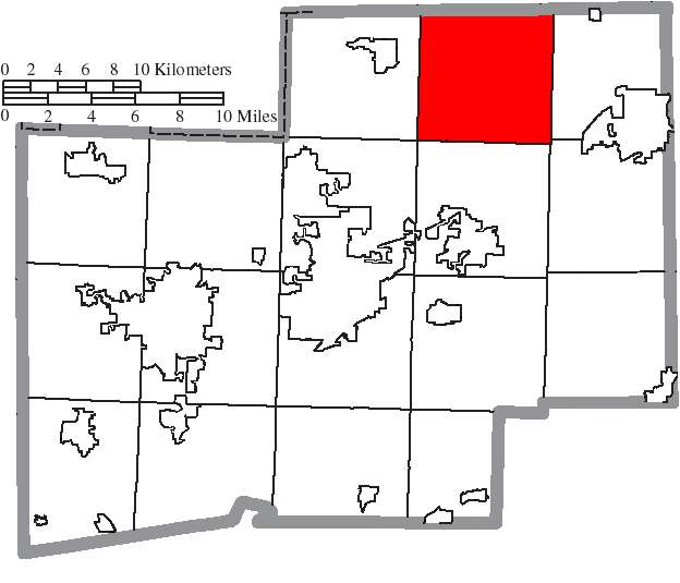
Photo: Ruhrfisch and Nyttend, CC BY-SA 3.0 · Wikimedia Commons
Local history sources: en.wikipedia.org · en.wikipedia.org · en.wikipedia.org · commons.wikimedia.org · archive.org · archive.org · archive.org · archive.org · archive.org · archive.org · archive.org · archive.org · archive.org · archive.org · en.wikipedia.org
Historic places
1 place in Marlboro Township, Stark County on the National Register of Historic Places. Press a pin or a name for its whole record.
-
New Baltimore InnBuilding · New Baltimore · listed 1975
- Address
- 14722 Ravenna Ave.
- Where
- New Baltimore, Stark County · ZIP 44601
- What it is
- Building
- Listed on the National Register
- 1975
- NRIS reference number
- 75001535
- Coordinates
- 40.98452, -81.24910
National Register file (NPS) ↗ Search Wikipedia ↗ Street map and directions ↗ On the Cracked Buckeye map
Source: National Park Service, National Register of Historic Places point file. The listing year is shown where NPS's certification date agrees with the listing's reference number. Listing recognizes significance; it does not restrict a private owner.
Water
Mostly private wells The water here
- Alliance City55% of residentsWalborn Reservoir + Deer Creek Reservoir + Mahoning River
- Louisville City32% of residentsLocal groundwater wells (Stark County)
- Canton Public Water System12% of residentsGlacial sand-and-gravel aquifer (3 well fields)
- North Canton City1% of residentsWells in buried valley & Massillon Sandstone aquifers
Hospitals, fire stations and more
Inside Marlboro Township, Stark County's boundary: 1 fire or EMS station, 1 public school, 1 private school, 5 poor-rated bridges, 1 police station, 3 shale and injection wells, 1 Toxics Release Inventory facility and 3 spill cases. Press a pin or a name for its whole record and its source.
Fire and EMS stations (1)
-
Marlboro Township Fire CompanyAlliance
- Address
- 9577 Edison Street Northeast, Alliance, OH 44601
- Coordinates
- 40.95126, -81.21473
USGS National Map structures (source) ↗ Street map and directions ↗
Source: USGS National Map structures (most Ohio records last updated 2019 to 2022), checked against the Columbus and Cleveland station lists. The department that answers a call is set by jurisdiction and mutual aid, not by distance.
Public schools (1)
-
Marlboro Elementary3.5 of 5 stars · Louisville
- Address
- 8131 Edison St, Louisville, OH 44641
- School district
- Marlington Local School District
- Kind (NCES)
- Regular School
- Students, 2023-24
- 213
- Teachers (full-time equivalent)
- 13.5
- Report card, 2025-26
- 3.5 of 5 stars
- Performance index
- 85.3%
- Ohio building IRN
- 019223
- NCES school ID
- 390498806061
NCES school record ↗ Ohio School Report Card ↗ Street map and directions ↗
Source: NCES EDGE public school locations 2024-25 and Common Core of Data 2023-24 (type, students, teachers); Ohio School Report Cards 2025-26 (Department of Education and Workforce), matched by name within the district.
Private schools (1)
-
Good Shepherd Christian AcademyPrivate, conservative Christian · Louisville
- Address
- Po Box 169, Louisville, OH 44641
- Kind
- conservative Christian
- Students, 2023-24
- 23
- Teachers (full-time equivalent)
- 2
- Students per teacher
- 11.5
- Phone
- (330) 935-0132
- NCES private school ID
- A0108637
Source: NCES Private School Survey 2023-24.
Bridges rated poor (5)
-
Ma0527 Gopp over Stark Portage DitchPoor · built 1954
- Condition
- Poor: a deck, superstructure, substructure or culvert rated 4 or below on the 0 to 9 scale
- What it is
- Bridge
- Built
- 1954
- Length
- 8 ft
- Owner
- County
- Vehicles a day
- 209
- Coordinates
- 40.98354, -81.26965
National Bridge Inventory (source) ↗ Street map and directions ↗
-
Ma0626 Pinedale over Stark Portage DitchPoor · built 1938
- Condition
- Poor: a deck, superstructure, substructure or culvert rated 4 or below on the 0 to 9 scale
- What it is
- Bridge
- Built
- 1938
- Length
- 11 ft
- Owner
- County
- Vehicles a day
- 324
- Coordinates
- 40.98187, -81.29068
National Bridge Inventory (source) ↗ Street map and directions ↗
-
Ma1918 Smth-Kramer over Big Swartz DitchPoor · built 1957
- Condition
- Poor: a deck, superstructure, substructure or culvert rated 4 or below on the 0 to 9 scale
- What it is
- Bridge
- Built
- 1957
- Length
- 13 ft
- Owner
- County
- Vehicles a day
- 485
- Coordinates
- 40.93881, -81.28692
National Bridge Inventory (source) ↗ Street map and directions ↗
-
Ma3032 Nimishil Ch over Swartz DitchPoor · built 1980
- Condition
- Poor: a deck, superstructure, substructure or culvert rated 4 or below on the 0 to 9 scale
- What it is
- Culvert
- Built
- 1980
- Length
- 9 ft
- Owner
- County
- Vehicles a day
- 324
- Coordinates
- 40.92560, -81.30318
National Bridge Inventory (source) ↗ Street map and directions ↗
-
Ma3113 State over Midd Branch NimishillenPoor · built 1948
- Condition
- Poor: a deck, superstructure, substructure or culvert rated 4 or below on the 0 to 9 scale
- What it is
- Bridge
- Built
- 1948
- Length
- 12 ft
- Owner
- County
- Vehicles a day
- 5,700
- Coordinates
- 40.90625, -81.30366
National Bridge Inventory (source) ↗ Street map and directions ↗
Source: FHWA National Bridge Inventory 2025. "Poor" means one major part rated 4 or below on the 0 to 9 scale; it calls for repair, not closing, unless the state posts or closes the bridge.
Police stations (1)
-
Marlboro Township Police DepartmentHartville
- Address
- 7344 Edison Street Northeast, Hartville, OH 44632
- Coordinates
- 40.95209, -81.25730
USGS National Map structures (source) ↗ Street map and directions ↗
Source: USGS National Map structures, police stations, corrected and completed by hand (September 2026). The department that answers a call is set by jurisdiction, not by distance.
Shale and injection wells (3)
-
Belden & Blake Corp {Swiw#5} 2-1050 InjectionInjection well (Class II)
- What it is
- Injection well (Class II)
- Operator
- Select Water Solutions, Llc
- County
- Stark County
- API well number
- 34151234200000
- Coordinates
- 40.95031, -81.24868
ODNR oil and gas wells (source) ↗ Street map and directions ↗
-
Frank Unit 2-HUtica shale well
- What it is
- Utica shale well
- Drilled sideways
- Yes
- Operator
- Eog Ohio, Llc
- County
- Stark County
- API well number
- 34151257350000
- Coordinates
- 40.94949, -81.18910
ODNR oil and gas wells (source) ↗ Street map and directions ↗
The point is the surface well head (the pad); a horizontal well runs a mile or more underground from it.
-
Gibbs Unit(Swiw #26) 1-K InjectionInjection well (Class II)
- What it is
- Injection well (Class II)
- Operator
- Ows Acquisition Co Llc
- County
- Stark County
- API well number
- 34151252370000
- Coordinates
- 40.95611, -81.18828
ODNR oil and gas wells (source) ↗ Street map and directions ↗
Source: ODNR Division of Oil and Gas Resources well inventory (September 2026): drilled Utica, Marcellus and horizontal wells and Class II injection wells not plugged. Older vertical wells are on the full map.
Facilities reporting toxic releases (1)
-
Buckeye Packaging Co Inc (1576011509)Toxics Release Inventory · Alliance
- Address
- 12223 Marlboro Ave, Alliance, OH 44601
- County
- Stark County
- Status
- Reports to the Toxics Release Inventory (active)
- EPA program ID
- 44601BCKYP12223
- EPA registry ID
- 110004591433
EPA facility record ↗ EPA Facility Registry Service (source) ↗ Street map and directions ↗
Source: EPA Facility Registry Service, Toxics Release Inventory reporters. Reporting a release is required of large users of listed chemicals; it is not by itself a violation.
Spills reported since 2021 (3)
-
Waste Water Reached water2024-07-10 · Marlboro Twp
- Reported
- 2024-07-10
- What spilled
- Waste Water
- Reached a waterway
- 99 - Unnamed
- Where
- Marlboro Twp, Stark County
- Ohio EPA district office
- NEDO
- Ohio EPA case number
- 2407EPA0001162
Ohio EPA spill reports (source) ↗ Street map and directions ↗
-
Oil Transformer Non Pcb2024-01-09 · Marlboro Twp
- Reported
- 2024-01-09
- What spilled
- Oil Transformer Non Pcb
- Largest amount reported
- 20 gallons
- Where
- Marlboro Twp, Stark County
- Ohio EPA district office
- NEDO
- Ohio EPA case number
- 2401EPA0000047
Ohio EPA spill reports (source) ↗ Street map and directions ↗
-
Brine Oil And Gas Related Reached water2022-06-06 · Nimishillen Twp
- Reported
- 2022-06-06
- What spilled
- Brine Oil And Gas Related
- Largest amount reported
- 8,400 gallons
- Reached a waterway
- 99 - Unnamed
- Where
- Nimishillen Twp, Stark County
- Ohio EPA district office
- NEDO
- Ohio EPA case number
- 2206EPA0000838
Ohio EPA spill reports (source) ↗ Street map and directions ↗
Source: Ohio EPA emergency response spill reports, 2021 to September 2026, one point per case where Ohio EPA placed it. A report is what the caller or responder recorded; amounts are often blank or estimated.
Its ZIP codes
Each ZIP code that touches Marlboro Township, Stark County, with the share of its residents who live here and the same headline figures as the ZIP page.
Local government
Who holds office in Marlboro Township, Stark County, how its elections and ballot issues came out, and the state auditor's record.
Who holds office
| Office | Name | Party | Term ends | Contact |
|---|---|---|---|---|
| Trustee | Wayne C. Schillig | R | 2027-12-31 | 330-206-6187 10750 Marlboro Ave. NE Alliance 44601 |
| Trustee | John C. Battershell | R | 2029-12-31 | 330-472-2324 7505 Allen Dr. NE Hartville 44632 |
| Trustee | Ken Eddleman | R | 2029-12-31 | 330-428-3234 10351 Marlboro Ave. NE Louisville 44641 |
| Fiscal Officer | Tracy M. Ferrett | R | 2028-03-31 | 330-209-5883 6497 Fernlane Cir. NE Hartville 44632 |
Roster as of 2026-08-12: county board of elections.
Money issues on the ballot since 2015: 6 of 7 passed.
Ballot issues
| Date | Issue | For | Against | Result |
|---|---|---|---|---|
| 2025-11-04 | Issue: Marlboro Township Police District | 920 | 445 | Passed (67.4% for) |
| 2025-11-04 | Issue: Local Option - Marlboro Twp 3 | 0 | 0 | Failed |
| 2025-11-04 | Issue: Local Option - Marlboro Twp 3 - Sunday | 0 | 0 | Failed |
| 2025-11-04 | Issue: Local Option - Marlboro Twp 1 | 0 | 0 | Failed |
| 2024-11-05 | Issue: Marlboro Township | 1,670 | 913 | Passed (64.65% for) |
| 2023-05-02 | Issue: Local Option - Marlboro Township 1 | 0 | 0 | Failed |
| 2021-11-02 | Issue: Marlboro Township Road Renewal | 868 | 366 | Passed (70.34% for) |
| 2021-05-04 | Issue: Marlboro Twp Police District | 412 | 90 | Passed (82.07% for) |
| 2020-11-03 | Issue: Marlboro Township, Current Expenses | 967 | 1,606 | Failed (37.58% for) |
| 2019-11-05 | Issue: Marlboro Twp Fire | 925 | 574 | Passed (61.71% for) |
| 2016-11-08 | Issue: Marlboro Township, Roads | 1,620 | 774 | Passed (67.67% for) |
| 2015-11-03 | Issue: Marlboro Twp Fire | 880 | 645 | Passed (57.7% for) |
Elections for office
| Date | Office | Candidates and votes |
|---|---|---|
| 2025-11-04 | Trustee | John C. Battershell 1,038, 52.91%; Ken Eddleman 924, 47.09% |
| 2023-11-07 | Trustee | Wayne C. Schillig 1,578, 100.0% |
| 2023-11-07 | Fiscal Officer | Tracy M. Ferrett 1,336, 100.0% |
| 2021-11-02 | Trustee | John C. Battershell 938, 54.41%; Ken P. Eddleman 786, 45.59% |
| 2019-11-05 | Trustee | Wayne C. Schillig 1,254, 100.0% |
| 2019-11-05 | Fiscal Officer | Tracy M. Ferrett 985, 100.0% |
| 2017-11-07 | Trustee (number of seats not on file, so winners are not marked) | John C. Battershell 908, 40.12%; Ken P. Eddleman 680, 30.05%; John P. Hagan 675, 29.83% |
| 2015-11-03 | Trustee | Wayne C. Schillig 1,305, 100.0% |
| 2015-11-03 | Fiscal Officer | Tracy M. Ferrett 957, 100.0% |
Winners in bold. Results from the county board of elections' official canvass unless marked.
Auditor of State record
- No fiscal caution, watch or emergency on the Auditor of State's lists.
- Agreed Upon Procedures, 2022 to 2023, released 2024-09-19
The county
Stark County: 34 ZIP codes, 36 cities, villages and townships, 374,115 people.
Nearby places
Quick answers
What county is Marlboro Township, Ohio in?
Marlboro Township, Stark County is a township in Stark County, Ohio, with 4,277 residents.
When was Marlboro Township, Ohio founded?
Marlboro Township, Stark County was settled 1805 (Mahlon Wileman, autumn); laid out November 1827 (village of Marlborough); incorporated June 1821 (township ordered; election August 25, 1821). Founders on record: Mahlon Wileman (first settler); Moses Pennock, William Pennock, Samuel Ellison and Denny Johnson (village plat). Source
What ZIP code is Marlboro Township, Ohio?
Marlboro Township, Stark County is served by ZIP codes 44632, 44641, 44601 and 44721; 44632 holds the largest share of its residents.
Where does Marlboro Township, Ohio get its water?
The main water source for Marlboro Township, Stark County (Alliance City): Mostly private wells.
Cite this page
Cite this page as:
Cracked Buckeye, "Marlboro Township, Stark County", https://crackedbuckeye.com/place/marlboro-township-stark-county/, built 2026-10-31, accessed [date].
How to cite · Report a correction · Built 2026-10-31
