Local events in Jackson Township, Montgomery County
Nothing is posted for Jackson Township itself yet; here is what is on within 10 miles. All local events in Jackson Township, Montgomery County
Know a calendar we should watch? Send the link
Checked October 20; the events page is refreshed daily.
How Jackson Township, Montgomery County began
Jackson Township, in the western tier of Montgomery County along Big Twin, Little Twin and Tom's Run creeks, first appeared as a subdivision of the county on June 6, 1814, with its present thirty-six-square-mile boundary set in 1820. The land was settled shortly after neighboring German and Jefferson townships, once it opened to regular purchase in 1801, and the earliest recorded land buyers took up their quarter-sections between 1805 and 1814. It remained an agricultural township of farms, mills and country churches through the nineteenth century, and it holds the village of Farmersville within its borders and part of New Lebanon on its northeastern edge; the larger, separately incorporated communities of Germantown and West Alexandria lie next to or near it but are not part of the township. Today it is still mostly farmland with a population of just over six thousand.
Settled 1801-1814 (land purchases), by First documented land purchasers under the state auditor's records: Christopher Mason (NE quarter, May 29, 1805), Abraham Hoover (SE quarter, March 25, 1805; SW quarter, October 3, 1814), John Miller (NW quarter, October 30, 1810).
Where the name comes from
No known source explains why the township carries the Jackson name; Ohio has thirty-seven Jackson Townships, a name common across the state's township-naming era. Nothing found ties this one specifically to Andrew Jackson or any other namesake.
Before the town
No mound, village, trail or treaty site specific to present-day Jackson Township was found in the sources checked. The township's land lay within the Great Miami valley country contested and hunted by the Miami, in alliance with the Shawnee, Wyandot, Potawatomi and Ottawa, before the 1795 Treaty of Greenville opened the region to settlement (per the county-level Dayton-area sources reviewed for this project); no source found names a specific camp, trail or burial site within the township's own boundaries.
Nations recorded here: Miami, Shawnee, Wyandot, Potawatomi, Ottawa.
Timeline
- — Land in the future Jackson Township area opened to regular settlement, following settlement already underway in neighboring German and Jefferson townships.
- — Christopher Mason purchased the northeast quarter-section, among the earliest recorded land buys in the township.
- — Abraham Hoover purchased the southeast quarter-section.
- — John Miller purchased the northwest quarter-section.
- — Jackson Township was first organized as a subdivision of Montgomery County.
- — Abraham Hoover purchased the southwest quarter-section, completing the earliest documented round of land purchases in the township.
- — Philip and Elizabeth Slifer deeded land on what is now Clayton Road, near Farmersville, to the local German Reformed and Evangelical Lutheran community, the origin of Slifers Presbyterian Church.
- — During an outbreak of the 'cold plague,' a malaria-like illness, the Rev. Thomas Winters (German Reformed) and Rev. John C. Dill (Evangelical Lutheran) ministered to the sick in the Slifer congregation and the community began building its first log church, completed in 1825.
- — Jackson Township's boundaries were set essentially as they remain today.
- — The present Slifers Presbyterian Church building on Clayton Road was erected by architect William Blum of Dayton and local builder Charles Routzahn, replacing an 1858 brick church.
- — After 134 years as a joint German Reformed/Evangelical Lutheran congregation, Slifers Church voted to become Presbyterian; the same year, Farmersville's Winter Zellar 'Zero' Swartsel, builder of the Bottle Farm roadside attraction, died and willed his land to the township for a children's recreation park.
Stories
The bridge over Tom's Run
A plate-girder railroad bridge built in the 1890s for the Cincinnati, Jackson and Mackinaw Railroad still stands over Tom's Run in the western part of the township, near Farmersville, on the abandoned route later run by Penn Central. The Cincinnati, Jackson and Mackinaw was one of the many nineteenth-century short lines that never reached all the places in its title: its main line ran only from Addison, Michigan, south to Carlisle near Franklin in Warren County, and never got to Cincinnati or to Mackinaw City. The bridge's deeper center span, built to carry heavier freight loads than its shorter end spans, is a design feature the Library of Congress's Historic American Engineering Record singled out as a good example of nineteenth-century railroad bridge practice when it documented the structure in 1994. Original stone abutments from the bridge's construction still stand on the hillside south of the crossing.
Slifers Church and the cold plague
In December 1816, Philip and Elizabeth Slifer deeded land at what is now the corner of Clayton and Chicken Bristle roads, south of Farmersville, to the German-speaking families who had settled the area, for use as a church and burying ground. Before any building went up, an outbreak of the 'cold plague' -- a malaria-like sickness -- struck the settlement in 1819, and the Reverend Thomas Winters of the German Reformed Church and the Reverend John C. Dill of the Evangelical Lutheran Church spent that year ministering to the sick and the grieving, work that is remembered as having renewed the congregation's faith. That same year the community, pooling what little money it had, began raising its first log church, finished in 1825 and enlarged later that year. A brick church replaced it in 1858 for $500, and the building standing today, designed by Dayton architect William Blum and built by local builder Charles Routzahn, dates to 1896. The congregation, jointly German Reformed and Evangelical Lutheran for 134 years, became Slifers Presbyterian Church in 1953.
Photographs
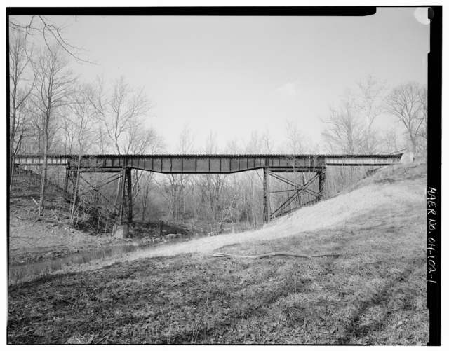
Photo: Historic American Engineering Record, Library of Congress (HAER OHIO,57-FARMV.V,2-1), public domain · Wikimedia Commons
Local history sources: jtwpmc.com · en.wikipedia.org · hmdb.org · loc.gov · commons.wikimedia.org · en.wikipedia.org · en.wikipedia.org · en.wikipedia.org
Water
Mostly private wells The water here
- New Lebanon Village46% of residentsGroundwater wells (3 wells)
- Farmersville Village46% of residentsGroundwater wells (2 wells)
- Germantown City7% of residentsGroundwater wells (4 wells)
- Voyager Village MHP1% of residentsGroundwater wells (2 wells)
- Southwest Regional Water District0% of residentsGreat Miami Buried Valley Aquifer (wells)
- Jefferson Regional Water Authority0% of residentsGroundwater wells (2 wells)
Hospitals, fire stations and more
Inside Jackson Township, Montgomery County's boundary: 1 poor-rated bridge and 3 spill cases. Press a pin or a name for its whole record and its source.
Bridges rated poor (1)
-
Preble Co Line C23 over Twin CreekPoor · built 1962
- Condition
- Poor: a deck, superstructure, substructure or culvert rated 4 or below on the 0 to 9 scale
- What it is
- Bridge
- Built
- 1962
- Length
- 101 ft
- Owner
- County
- Vehicles a day
- 979
- Coordinates
- 39.66191, -84.48001
National Bridge Inventory (source) ↗ Street map and directions ↗
Source: FHWA National Bridge Inventory 2025. "Poor" means one major part rated 4 or below on the 0 to 9 scale; it calls for repair, not closing, unless the state posts or closes the bridge.
Spills reported since 2021 (3)
-
Material Unknown2026-08-26 · Jackson Twp
- Reported
- 2026-08-26
- What spilled
- Material Unknown
- Where
- Jackson Twp, Montgomery County
- Ohio EPA district office
- SWDO
- Ohio EPA case number
- 2608EPA0001602
Ohio EPA spill reports (source) ↗ Street map and directions ↗
-
Fertilizer(S) Nos (Not Specified)2026-05-18 · Jackson Twp
- Reported
- 2026-05-18
- What spilled
- Fertilizer(S) Nos (Not Specified)
- Where
- Jackson Twp, Montgomery County
- Ohio EPA district office
- SWDO
- Ohio EPA case number
- 2605EPA0000833
Ohio EPA spill reports (source) ↗ Street map and directions ↗
-
Fish Kill Reached water2026-04-18 · Jackson Twp
- Reported
- 2026-04-18
- What spilled
- Fish Kill
- Reached a waterway
- 99 - Unnamed
- Where
- Jackson Twp, Montgomery County
- Ohio EPA district office
- SWDO
- Ohio EPA case number
- 2604EPA0000652
Ohio EPA spill reports (source) ↗ Street map and directions ↗
Source: Ohio EPA emergency response spill reports, 2021 to September 2026, one point per case where Ohio EPA placed it. A report is what the caller or responder recorded; amounts are often blank or estimated.
Its ZIP codes
Each ZIP code that touches Jackson Township, Montgomery County, with the share of its residents who live here and the same headline figures as the ZIP page.
| ZIP | Share | Water | Radon | Home value | Schools | Flood |
|---|---|---|---|---|---|---|
| 45325 Jackson Township and Farmersville | 59% | Mostly private wells | 5.5 pCi/L average radon | Median year built 1960 | Valley View Local · 4 stars overall | 3.6% of residents in the 1% floodplain |
| 45345 New Lebanon | 16% | Groundwater wells (3 wells) | 5.6 pCi/L average radon | Median year built 1962 | New Lebanon Local · 3 stars overall | 0.5% of residents in the 1% floodplain |
| 45327 Germantown | 2% | Groundwater wells (4 wells) | 6.8 pCi/L average radon | Median year built 1968 | Valley View Local · 4 stars overall | 9.9% of residents in the 1% floodplain |
Local government
Who holds office in Jackson Township, Montgomery County, how its elections and ballot issues came out, and the state auditor's record.
Money issues on the ballot since 2025: 3 of 3 passed.
Ballot issues
| Date | Issue | For | Against | Result |
|---|---|---|---|---|
| 2026-05-05 | Issue: Jackson Township (Unincorporated) - Renewal - Road - 2 Mills - 4 yrs (2.0 mills, renewal) | 271 | 218 | Passed (55.42% for) |
| 2026-05-05 | Issue: Jackson Township - Renewal - Police - 1.8 Mills - 5 yrs (1.8 mills, renewal) | 270 | 220 | Passed (55.1% for) |
| 2025-05-06 | Issue: Jackson Township Police (Unincorp) - Renewal 2 mills - 5 yrs (2.0 mills, renewal) | 218 | 104 | Passed (67.7% for), unofficial |
Elections for office
| Date | Office | Candidates and votes |
|---|---|---|
| 2025-11-04 | Trustee (unofficial count) | Bob Cowden 160, 7.41%; Randall DeVilbiss 371, 17.18%; Jim Erisman 631, 29.21%; Ryan L. Hodson 635, 29.4%; Matt Thaxton 363, 16.81% |
Winners in bold. Results from the county board of elections' official canvass unless marked.
Auditor of State record
- No fiscal caution, watch or emergency on the Auditor of State's lists.
- Agreed Upon Procedures, 2024 to 2025, released 2026-06-09
The county
Montgomery County: 33 ZIP codes, 27 cities, villages and townships, 531,614 people.
Nearby places
Quick answers
What county is Jackson Township, Ohio in?
Jackson Township, Montgomery County is a township in Montgomery County, Ohio, with 2,609 residents.
When was Jackson Township, Ohio founded?
Jackson Township, Montgomery County was settled 1801-1814 (land purchases). Founders on record: First documented land purchasers under the state auditor's records: Christopher Mason (NE quarter, May 29, 1805), Abraham Hoover (SE quarter, March 25, 1805; SW quarter, October 3, 1814), John Miller (NW quarter, October 30, 1810). Source
How did Jackson Township, Ohio get its name?
No known source explains why the township carries the Jackson name; Ohio has thirty-seven Jackson Townships, a name common across the state's township-naming era. Source
What ZIP code is Jackson Township, Ohio?
Jackson Township, Montgomery County is served by ZIP codes 45325 and 45345; 45325 holds the largest share of its residents.
Where does Jackson Township, Ohio get its water?
The main water source for Jackson Township, Montgomery County (New Lebanon Village): Mostly private wells.
Cite this page
Cite this page as:
Cracked Buckeye, "Jackson Township, Montgomery County", https://crackedbuckeye.com/place/jackson-township-montgomery-county/, built 2026-10-31, accessed [date].
How to cite · Report a correction · Built 2026-10-31