Local events in Buckskin Township, Ross County
Nothing is posted for Buckskin Township itself yet; here is what is on within 10 miles. All local events in Buckskin Township, Ross County
Know a calendar we should watch? Send the link
Checked October 20; the events page is refreshed daily.
How Buckskin Township, Ross County began
Buckskin Township was organized on August 10, 1807 out of parts of Paxton and Concord townships in western Ross County, and takes its name from Buckskin Creek, which drains the township; no source found records who first applied that name or why. Its main community, South Salem, grew up around a Presbyterian academy: minister Hugh Stewart Fullerton opened Salem Academy in 1842 to serve a rural district with no upper-level school, and landowner John Sample platted the village around it in 1846. The academy taught more than 1,500 students, including future Ohio governor Joseph B. Foraker, before closing in the early twentieth century; its 1842 limestone building still stands and is listed on the National Register. A mile or so away, the 1873 South Salem Covered Bridge carries Lower Twin Road over Buckskin Creek and is the last covered bridge standing in Ross County. The township is rural farm country today, with a 2020 population of 1,828 and no other incorporated village besides South Salem.
Settled 1804, when the family of early settler Henry Haute arrived from Pennsylvania, among the township's first settlers, incorporated 1807-08-10 (Buckskin Township organized from parts of Paxton and Concord townships), by Ross County commissioners; early settlers named in the county history include Henry Haute's father, James Wilson, John H. Wilson, Frederick Parrott, John Wallace, S. Scott and J. McGinnis.
Where the name comes from
The township is named for Buckskin Creek, the stream that drains it and that the South Salem Covered Bridge crosses; Ohio has no other Buckskin Township. No source we found states who named the creek or when, or whether the name refers to the deerskin trade with Native hunters and traders that was common across the Ohio country before and during early settlement; that connection is plausible given the name but is not documented in any source we found and should not be presented as established fact.
Before the town
No source found names a specific Native village, trail, treaty or documented encounter within Buckskin Township's boundaries; the township's own local histories, once settlement narratives begin in the early 1800s, describe farm families arriving from Pennsylvania and Virginia with no mention of Native residents already on the ground. The township's name, Buckskin, after the creek that drains it, may echo the deerskin trade that was central to relations between Ohio Native nations and early Euro-American traders, but that is inference rather than a sourced fact. Ross County's wider record includes the Shawnee towns on the Scioto, the Adena and Hopewell mound-building traditions, the Treaty of Greenville's bearing on the county, and the last documented Native presence in the county; nothing found narrows any of that specifically to Buckskin Township's ground.
Timeline
- — The family of Henry Haute emigrates from Pennsylvania and settles in the future Buckskin Township, among its earliest settlers.
- — Ross County commissioners organize Buckskin Township from parts of Paxton and Concord townships.
- — Presbyterian minister Hugh Stewart Fullerton opens Salem Academy in southwestern Ross County after finding no upper-level school served the district; the stone building is completed the same year with stone from a quarry near Greenfield.
- — Landowner John Sample plats the village of South Salem around the academy to serve its students and teachers; the first house in the new village is built by M. Douglas.
- — South Salem records its peak population of 479 residents.
- — The South Salem Covered Bridge, a Smith-truss wooden bridge built by the Smith Bridge Company and Robert Matthews, is completed over Buckskin Creek on Lower Twin Road.
- — South Salem Academy closes, unable to compete with the growing number of public high schools in the region; the village's population declines afterward.
- — The academy building is sold to the Buckskin Township Board of Education after decades of declining enrollment.
- — The South Salem Covered Bridge, by then the only covered bridge surviving in Ross County, is listed on the National Register of Historic Places.
- — South Salem Academy is listed on the National Register of Historic Places.
Stories
A School Built Because There Wasn't One
In 1841 the Reverend Hugh Stewart Fullerton put a plain question to his Presbyterian congregation in the farm country of southwestern Ross County: should they try to build an academy, so that the young people of this remote district would not have to leave home to get an education past the common schools? The congregation said yes, and by the end of 1842 a two-story building of cut limestone stood on the site, quarried from a pit near Greenfield and finished in the Federal style with a cupola on the roof. Landowner John Sample saw an opportunity in the new school and in 1846 platted a village around it, South Salem, which grew fast for its first two years and then held steady near five hundred people through the mid-1800s. Over sixty-five years the academy taught more than 1,500 students, including three future U.S. congressmen and Joseph B. Foraker, who went on to become governor of Ohio -- an outsized legacy for a school built on one minister's conviction that his neighbors' children deserved better than what the district already had.
Ross County's Last Covered Bridge
By the early twentieth century Ross County had several covered bridges spanning its creeks, wooden structures roofed to protect their trusses from the weather. One by one, flood, fire, replacement and neglect took them, until only the South Salem Covered Bridge remained: built in 1873 by the Smith Bridge Company and Robert Matthews over Buckskin Creek, using a truss design patented by Ohio bridge-builder Robert Smith in the late 1860s, eight panels wide, resting on stone abutments under a metal roof. It carries Lower Twin Road a short distance from the village whose academy it long served, and its survival, more than its engineering alone, is what earned it a place on the National Register of Historic Places in 1975 -- the last of its kind standing in a county that once had several.
Photographs
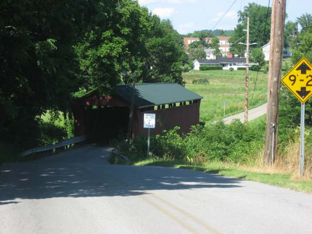
Photo: photo by Nyttend, public domain · Wikimedia Commons
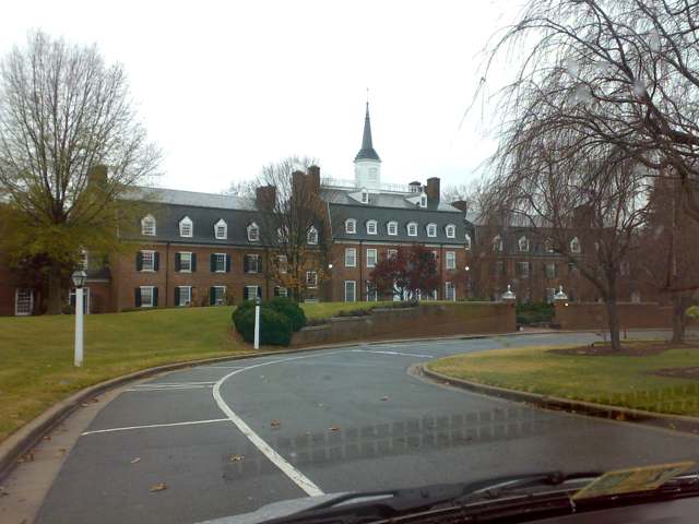
Photo: photo by Bjoertvedt, CC BY-SA 3.0 · Wikimedia Commons
Local history sources: en.wikipedia.org · sites.rootsweb.com · en.wikipedia.org · en.wikipedia.org · en.wikipedia.org · commons.wikimedia.org · commons.wikimedia.org
Historic places
1 place in Buckskin Township, Ross County on the National Register of Historic Places. Press a pin or a name for its whole record.
-
South Salem Covered BridgeStructure · South Salem · listed 1975
- Address
- W of South Salem on Lower Twin Rd. across Buckskin Creek
- Where
- South Salem, Ross County · ZIP 45681
- What it is
- Structure
- Listed on the National Register
- 1975
- NRIS reference number
- 75001530
- Coordinates
- 39.33435, -83.31434
National Register file (NPS) ↗ Search Wikipedia ↗ Street map and directions ↗ On the Cracked Buckeye map
Source: National Park Service, National Register of Historic Places point file. The listing year is shown where NPS's certification date agrees with the listing's reference number. Listing recognizes significance; it does not restrict a private owner.
Water
Eight wells in the buried Teays River Aquifer, in the Scioto valley north of Chillicothe The water here
- Ross County Water Co. Inc52% of residentsTeays Valley Aquifer (buried valley groundwater)
- Greenfield Village45% of residentsGroundwater wells (8 wells)
- Frankfort Village3% of residentsGroundwater wells (2 wells)
Hospitals, fire stations and more
Inside Buckskin Township, Ross County's boundary: 1 power plant, 2 poor-rated bridges and 2 spill cases. Press a pin or a name for its whole record and its source.
Power plants (1)
-
Ross County Solar, LLC 100 MW or moreSolar · 120 MW
- Capacity
- 120 MW
- Main source
- Solar
- Technology
- Solar Photovoltaic
- Operator
- Ross County Solar, LLC
- Sector
- IPP Non-CHP
- Where
- Greenfield, Ross County
- Generating units
- 1
- Built
- 2025
- EIA plant code
- 65343
EIA plant page ↗ EIA-860 (source) ↗ Street map and directions ↗
Source: EIA-860 power plant inventory via HIFLD (February 2025), with plant codes, units and years from EIA-860 2025.
Bridges rated poor (2)
-
Edgington Rd over Lower Twin CreekPoor · built 1982
- Condition
- Poor: a deck, superstructure, substructure or culvert rated 4 or below on the 0 to 9 scale
- What it is
- Bridge
- Built
- 1982
- Length
- 8 ft
- Owner
- County
- Vehicles a day
- 324
- Coordinates
- 39.31541, -83.25608
National Bridge Inventory (source) ↗ Street map and directions ↗
-
Edgington Rd over Trib. Lower Twin CreekPoor · built 1974
- Condition
- Poor: a deck, superstructure, substructure or culvert rated 4 or below on the 0 to 9 scale
- What it is
- Bridge
- Built
- 1974
- Length
- 10 ft
- Owner
- County
- Vehicles a day
- 324
- Coordinates
- 39.31068, -83.26374
National Bridge Inventory (source) ↗ Street map and directions ↗
Source: FHWA National Bridge Inventory 2025. "Poor" means one major part rated 4 or below on the 0 to 9 scale; it calls for repair, not closing, unless the state posts or closes the bridge.
Spills reported since 2021 (2)
-
Bentonite / Drilling Mud2023-11-08 · Buckskin Twp
- Reported
- 2023-11-08
- What spilled
- Bentonite / Drilling Mud
- Largest amount reported
- 5 gallons
- Where
- Buckskin Twp, Ross County
- Ohio EPA district office
- SEDO
- Ohio EPA case number
- 2311EPA0001903
Ohio EPA spill reports (source) ↗ Street map and directions ↗
-
Oil Motor / Lube Oil / Vehicle2022-07-10 · Monroe Twp
- Reported
- 2022-07-10
- What spilled
- Oil Motor / Lube Oil / Vehicle
- Where
- Monroe Twp, Pickaway County
- Ohio EPA district office
- SEDO
- Ohio EPA case number
- 2207EPA0001045
Ohio EPA spill reports (source) ↗ Street map and directions ↗
Source: Ohio EPA emergency response spill reports, 2021 to September 2026, one point per case where Ohio EPA placed it. A report is what the caller or responder recorded; amounts are often blank or estimated.
Its ZIP codes
Each ZIP code that touches Buckskin Township, Ross County, with the share of its residents who live here and the same headline figures as the ZIP page.
| ZIP | Share | Water | Radon | Home value | Schools | Flood |
|---|---|---|---|---|---|---|
| 45681 Buckskin Township and South Salem | 37% | Eight wells in the buried Teays River Aquifer, in the Scioto valley north of Chillicothe | Too few radon tests | Median year built 1989 | Greenfield Exempted Village · 3.5 stars overall | 5.8% of residents in the 1% floodplain |
| 45123 Greenfield | 12% | Groundwater wells (8 wells) | 5.4 pCi/L average radon | Appraisal records without year built | Greenfield Exempted Village · 3.5 stars overall | 0.9% of residents in the 1% floodplain |
| 45628 Concord Township and Frankfort | 3% | Eight wells in the buried Teays River Aquifer, in the Scioto valley north of Chillicothe | Too few radon tests | Median year built 1989 | Adena Local · 3 stars overall | 6.4% of residents in the 1% floodplain |
The county
Highland County: 7 ZIP codes, 26 cities, villages and townships, 42,302 people.
Nearby places
Quick answers
What county is Buckskin Township, Ohio in?
Buckskin Township, Ross County is a township in Highland County, Ohio, with 1,828 residents.
When was Buckskin Township, Ohio founded?
Buckskin Township, Ross County was settled 1804, when the family of early settler Henry Haute arrived from Pennsylvania, among the township's first settlers; incorporated 1807-08-10 (Buckskin Township organized from parts of Paxton and Concord townships). Founders on record: Ross County commissioners; early settlers named in the county history include Henry Haute's father, James Wilson, John H. Wilson, Frederick Parrott, John Wallace, S. Scott and J. McGinnis. Source
How did Buckskin Township, Ohio get its name?
The township is named for Buckskin Creek, the stream that drains it and that the South Salem Covered Bridge crosses; Ohio has no other Buckskin Township. Source
What ZIP code is Buckskin Township, Ohio?
Buckskin Township, Ross County is served by ZIP codes 45681, 45123 and 45628; 45681 holds the largest share of its residents.
Where does Buckskin Township, Ohio get its water?
The main water source for Buckskin Township, Ross County (Ross County Water Co. Inc): Eight wells in the buried Teays River Aquifer, in the Scioto valley north of Chillicothe.
Cite this page
Cite this page as:
Cracked Buckeye, "Buckskin Township, Ross County", https://crackedbuckeye.com/place/buckskin-township-ross-county/, built 2026-10-31, accessed [date].
How to cite · Report a correction · Built 2026-10-31
