Local events in Paint Township, Highland County
Nothing is posted for Paint Township itself yet; here is what is on within 20 miles. All local events in Paint Township, Highland County
Know a calendar we should watch? Send the link
Checked October 20; the events page is refreshed daily.
How Paint Township, Highland County began
Paint Township lies in the east part of Highland County and takes its name from Paint Creek, a Scioto River tributary that runs through it. It contains no incorporated municipality; its best-documented place is the mill site on Rocky Fork Creek that grew into Barretts Mills, a 19th-century industrial hamlet with grist, saw, carding, fulling and woolen mills that later became a mid-20th-century tourist attraction before burning down in 1975 and 1980. The township today is mostly farmland, crossed by US Route 50 through the unincorporated community of Rainsboro.
Where the name comes from
Named for Paint Creek, a tributary of the Scioto River that runs through the township.
Before the town
No Native American village, mound, or trail specific to Paint Township is recorded in the sources checked, though Paint Creek itself carries a name of documented Shawnee-era significance regionally (the creek's name predates township organization). The land fell within the 1795 Treaty of Greenville cession.
Nations recorded here: Shawnee.
Timeline
- — Quaker settler Jesse Baldwin, from North Carolina, builds a grist mill and sawmill on Factory Branch Creek at what becomes Barretts Mills.
- — Baldwin sells the mill property to Hillsboro physician Dr. John Boyd.
- — Boyd sells the mills to David Barrett, for whom the site is later named.
- — David Barrett tears down the older mill buildings on Factory Branch and builds a much larger mill near Rocky Fork.
- — Businessman Jack Hope, who bought the mill in the 1960s, reopens it as a tourist attraction with a souvenir shop, blacksmith shop and riding trails.
- — Fire destroys the Barretts Mills woolen mill.
- — Fire destroys the covered bridge and the grist mill at Barretts Mills.
Stories
From cholera hospital to tourist trap: the life of Barretts Mills
Jesse Baldwin's 1805 grist and saw mills on Factory Branch Creek grew over fifteen years into a small industrial hamlet, adding carding, fulling and woolen mills that turned cotton and flax into cloth. When Dr. John Boyd bought the works in 1823 he converted a building near the woolen mill into a makeshift hospital to house cholera patients during the epidemics of the 1830s — a grim use for a mill town. David Barrett took over in 1855 and in 1858 built a much larger mill near Rocky Fork, where a covered bridge later crossed the creek. In the 1960s Highland County businessman Jack Hope bought the aging property and, in 1968, reopened it as a roadside attraction with a souvenir shop, a working blacksmith and riding trails — only to close it again in 1970. The mill's last chapter was fire: the woolen mill burned in 1975, and in 1980 flames took the grist mill and the covered bridge together.
Photographs
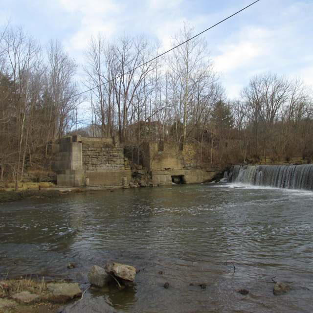
Photo: Aesopposea, via Wikimedia Commons, CC BY-SA 3.0 · Wikimedia Commons
Local history sources: en.wikipedia.org · timesgazette.com · en.wikipedia.org · en.wikipedia.org · commons.wikimedia.org
Historic places
2 places in Paint Township, Highland County on the National Register of Historic Places. Press a pin or a name for its whole record.
-
Barretts MillsHistoric district · Rainsboro · listed 1972
- Address
- CR 1A and Rocky Fork Creek
- Where
- Rainsboro, Highland County · ZIP 45612
- What it is
- Historic district
- Listed on the National Register
- 1972
- NRIS reference number
- 72001024
- Coordinates
- 39.20207, -83.38711
National Register file (NPS) ↗ Search Wikipedia ↗ Street map and directions ↗ On the Cracked Buckeye map
-
Barretts Mills (Boundary Increase)Historic district · Rainsboro · listed 1979
- Address
- On Factory Branch Creek
- Where
- Rainsboro, Highland County · ZIP 45612
- What it is
- Historic district
- Listed on the National Register
- 1979
- NRIS reference number
- 79003168
- Coordinates
- 39.20207, -83.38711
National Register file (NPS) ↗ Search Wikipedia ↗ Street map and directions ↗ On the Cracked Buckeye map
Source: National Park Service, National Register of Historic Places point file. The listing year is shown where NPS's certification date agrees with the listing's reference number. Listing recognizes significance; it does not restrict a private owner.
Water
Mostly private wells The water here
- Hillsboro City55% of residentsClear Creek (via Selph Road & Liberty Park Reservoirs)
- Highland County Water Company, Inc.19% of residentsSand-and-gravel aquifer wells (Ross/Highland Co. well fields; local wells)
- Greenfield Village15% of residentsGroundwater wells (8 wells)
- Ross County Water Co. Inc7% of residentsTeays Valley Aquifer (buried valley groundwater)
- Bainbridge Village5% of residentsGroundwater wells (2 wells)
- Leesburg Village1% of residentsGroundwater wells (4 wells)
Hospitals, fire stations and more
Inside Paint Township, Highland County's boundary: 1 health center, 1 high-hazard dam, 1 public school, 1 library, 1 museum and 4 spill cases. Press a pin or a name for its whole record and its source.
Community health centers (1)
-
Highland Health Providers - Rocky Fork Medical CenterHealth center · Hillsboro
- Run by
- a federally qualified health center
- Setting
- Clinic
- City
- Hillsboro
- Coordinates
- 39.19852, -83.48270
Find a Health Center (HRSA) ↗ HRSA data (source) ↗ Street map and directions ↗
Source: HRSA health center service delivery sites, active, September 2026 (school-based sites left out). Health centers see patients whether or not they have insurance, with fees on a sliding scale.
High-hazard dams (1)
-
Rocky Fork Lake Dam PoorRocky Fork of Paint Creek · condition: poor
- Hazard class
- High: a failure would probably cost a life
- Condition
- Poor (assessed 03/22/2024)
- River or stream
- Rocky Fork of Paint Creek
- Purpose
- Recreation
- Type
- Concrete
- Height
- 74 ft
- Storage
- 87,050 acre-feet
- Completed
- 1952
- Owner type
- State
- County
- Highland County
- Nearest town (NID)
- Mccoppin Mill
- Last inspection
- 06/06/2023
- Emergency action plan
- Yes
- NID ID
- OH00302
National Inventory of Dams record ↗ National Inventory of Dams (source) ↗ Street map and directions ↗
Source: U.S. Army Corps of Engineers National Inventory of Dams, August 2026. "High hazard" rates what a failure would cost downstream, not how likely one is; the condition is the state's assessment.
Public schools (1)
-
Rainsboro Elementary School4 of 5 stars · Bainbridge
- Address
- 12916 Barrett Mill Rd, Bainbridge, OH 45612
- School district
- Greenfield Ex Vill School District
- Kind (NCES)
- Regular School
- Students, 2023-24
- 216
- Teachers (full-time equivalent)
- 12
- Report card, 2025-26
- 4 of 5 stars
- Performance index
- 82.5%
- Ohio building IRN
- 031039
- NCES school ID
- 390454002205
NCES school record ↗ Ohio School Report Card ↗ Street map and directions ↗
Source: NCES EDGE public school locations 2024-25 and Common Core of Data 2023-24 (type, students, teachers); Ohio School Report Cards 2025-26 (Department of Education and Workforce), matched by name within the district.
Public libraries (1)
-
Rocky Fork BranchBranch · Hillsboro
- Address
- 11125 North Shore Drive, Hillsboro, OH 45133
- What it is
- Branch
- Library system
- Highland County District Library
- Open
- 1,768 hours a year, 52 weeks
- Building
- 3,775 sq ft
- System's visits, FY2024
- 115,752
- System's loans, FY2024
- 258,208
- People the system serves
- 42,139
- Phone
- (937) 661-6866
IMLS Public Libraries Survey (source) ↗ Street map and directions ↗
Source: IMLS Public Libraries Survey FY2024 (outlets and their systems). Any Ohio resident can get a free card at any Ohio public library.
Museums, historical societies, gardens and zoos (1)
-
Heartland Earthworks ConservancyHistorical society · Hillsboro
- What it is
- Historical society
- City
- Hillsboro
- Coordinates
- 39.19529, -83.42715
Search Wikipedia ↗ IMLS Museum Data Files (source) ↗ Street map and directions ↗
The museum list is IMLS's 2018 file; a museum may have closed or moved since.
Source: IMLS Museum Data Files, 2018.
Spills reported since 2021 (4)
-
Oil Petroleum Not Otherwise Specified (Nos)2024-05-20 · Paint Twp
- Reported
- 2024-05-20
- What spilled
- Oil Petroleum Not Otherwise Specified (Nos)
- Where
- Paint Twp, Highland County
- Ohio EPA district office
- SWDO
- Ohio EPA case number
- 2405EPA0000840
Ohio EPA spill reports (source) ↗ Street map and directions ↗
-
Fuel Diesel / Diesel Fuel (Vehicle On Or Off Road)2023-02-20 · Paint Twp
- Reported
- 2023-02-20
- What spilled
- Fuel Diesel / Diesel Fuel (Vehicle On Or Off Road)
- Largest amount reported
- 60 gallons
- Where
- Paint Twp, Highland County
- Ohio EPA district office
- SWDO
- Ohio EPA case number
- 2302EPA0000262
Ohio EPA spill reports (source) ↗ Street map and directions ↗
-
Fuel Gasoline ( 25% Ethanol Not E85) Reached water2026-08-22 · Paint Twp
- Reported
- 2026-08-22
- What spilled
- Fuel Gasoline ( 25% Ethanol Not E85)
- Largest amount reported
- 30 gallons
- Reached a waterway
- 99 - Unnamed
- Where
- Paint Twp, Highland County
- Ohio EPA district office
- SWDO
- Ohio EPA case number
- 2608EPA0001577
Ohio EPA spill reports (source) ↗ Street map and directions ↗
-
Drum(S)2026-06-08 · Paint Twp
- Reported
- 2026-06-08
- What spilled
- Drum(S)
- Where
- Paint Twp, Highland County
- Ohio EPA district office
- SWDO
- Ohio EPA case number
- 2606EPA0001011
Ohio EPA spill reports (source) ↗ Street map and directions ↗
Source: Ohio EPA emergency response spill reports, 2021 to September 2026, one point per case where Ohio EPA placed it. A report is what the caller or responder recorded; amounts are often blank or estimated.
Its ZIP codes
Each ZIP code that touches Paint Township, Highland County, with the share of its residents who live here and the same headline figures as the ZIP page.
| ZIP | Share | Water | Radon | Home value | Schools | Flood |
|---|---|---|---|---|---|---|
| 45133 Hillsboro | 16% | Mostly private wells | 4.2 pCi/L average radon | Appraisal records without year built | Hillsboro City · 3.5 stars overall | 0.2% of residents in the 1% floodplain |
| 45612 Paxton Township and Bainbridge | 12% | Mostly private wells | 3.9 pCi/L average radon | Median year built 1986 | Paint Valley Local · 3 stars overall | 2.4% of residents in the 1% floodplain |
| 45123 Greenfield | 6% | Groundwater wells (8 wells) | 5.4 pCi/L average radon | Appraisal records without year built | Greenfield Exempted Village · 3.5 stars overall | 0.9% of residents in the 1% floodplain |
| 45135 Fairfield Township and Leesburg | 1% | Mostly private wells | 4.8 pCi/L average radon | Appraisal records without year built | Fairfield Local · 4.5 stars overall | 1.3% of residents in the 1% floodplain |
Local government
Who holds office in Paint Township, Highland County, how its elections and ballot issues came out, and the state auditor's record.
Money issues on the ballot since 2021: 1 of 1 passed.
Ballot issues
| Date | Issue | For | Against | Result |
|---|---|---|---|---|
| 2021-11-02 | Issue: Paint Valley ADAMH (levy type not on the results report) | 2,893 | 2,134 | Passed (57.55% for), unofficial |
Elections for office
| Date | Office | Candidates and votes |
|---|---|---|
| 2023-11-07 | Trustee | Randy Mustard 900, 100.0% |
| 2023-11-07 | Fiscal Officer | Tara Matthews Campbell 865, 100.0% |
| 2021-11-02 | Township Trustee (unofficial count) | Corey J. Miller 282, 34.1%; Steven M. Karnes 200, 24.18%; Matthew Ingles 161, 19.47%; Josh Carroll 111, 13.42%; Kenneth Hinkle 73, 8.83% |
| 2019-11-05 | Trustee | Randy Mustard 316, 100.0% |
| 2019-11-05 | Fiscal Officer | Karen Rumbaugh 270, 100.0% |
Winners in bold. Results from the county board of elections' official canvass unless marked.
Auditor of State record
- No fiscal caution, watch or emergency on the Auditor of State's lists.
- Agreed Upon Procedures, 2023 to 2024, released 2025-07-22
The county
Highland County: 7 ZIP codes, 26 cities, villages and townships, 42,302 people.
Nearby places
Quick answers
What county is Paint Township, Ohio in?
Paint Township, Highland County is a township in Highland County, Ohio, with 4,850 residents.
How did Paint Township, Ohio get its name?
Named for Paint Creek, a tributary of the Scioto River that runs through the township. Source
What ZIP code is Paint Township, Ohio?
Paint Township, Highland County is served by ZIP codes 45133, 45612 and 45123; 45133 holds the largest share of its residents.
Where does Paint Township, Ohio get its water?
The main water source for Paint Township, Highland County (Hillsboro City): Mostly private wells.
Cite this page
Cite this page as:
Cracked Buckeye, "Paint Township, Highland County", https://crackedbuckeye.com/place/paint-township-highland-county/, built 2026-10-31, accessed [date].
How to cite · Report a correction · Built 2026-10-31
