Local events in Blue Ash
35 events in the next 90 days from 4 public calendars. All local events in Blue Ash
Checked October 20; the events page is refreshed daily.
Deep dives about Blue Ash
Long reads built from maps, newspapers and public records. All deep dives
- Lingering ash and the emerald ash borer in OhioThe emerald ash borer was found in Ohio in 2003 and reached all 88 counties by 2016. A few 'lingering ash' survived, and a breeding program in Delaware, Ohio is built on them.
- Ohio data centersWhere Ohio's 182 data centers sit, who is building them, the tax breaks, the power and water they need, and the moratoriums and ballot fights over them.
Notable people from Blue Ash
Ohioans tied to this place, each with a sourced profile. All notable Ohioans

Videos about Blue Ash
Short videos we made from the old maps and records. All videos
How Blue Ash began
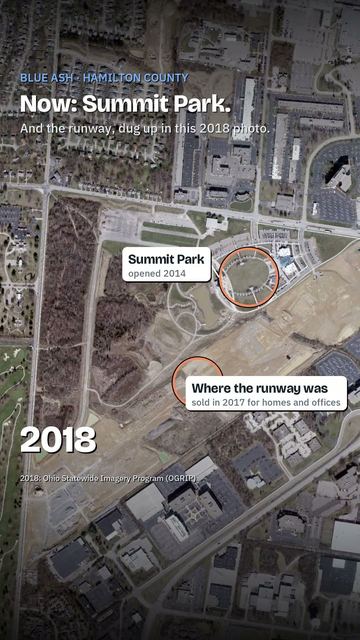
Settlers reached the area around 1791, and in 1797 the community's first church, Carpenter's Run Baptist Church, was built of blue ash logs -- Fraxinus quadrangulata -- giving the place its eventual name. Blue Ash's defining 20th-century institution was an airfield: opened in 1921 as Grisard Field and later Watson Airport, the City of Cincinnati bought it in 1946 to create Ohio's first municipal airport after the 1937 flood had knocked out Lunken Field. Blue Ash incorporated as a village in 1955 and a city in 1961 largely to gain zoning control over the airport and block Cincinnati's expansion plans for it; the airport nonetheless ran for 91 years before closing for good on August 29, 2012, and its runway land became Summit Park, the community's new civic center. An F4 tornado struck the city on April 9, 1999, killing four people, and Blue Ash's population reached 13,394 by 2020.
Settled c. 1791, incorporated village, 1955; city, 1961.
Where the name comes from
The community took its name from the blue ash tree (Fraxinus quadrangulata), the wood the first settlers used in 1797 to build Carpenter's Run Baptist Church, the area's earliest structure.
Before the town
No Native village, mound, or documented encounter specific to Blue Ash itself was found in the sources consulted.
Timeline
- — Settlers reach the area that becomes Blue Ash.
- — The first settlers build Carpenter's Run Baptist Church out of blue ash logs, giving the area its eventual name.
- — A dirt-runway airfield opens off Cooper Road in then-unincorporated Sycamore Township, serving as the departure point for the first Cincinnati-Chicago airmail flight; it is dedicated the next year as Grisard Field, for a Cincinnati-area pilot killed in World War I.
- — The Watson brothers buy the field and rededicate it as Watson Airport, with Eddie Rickenbacker in attendance; by 1928 it hosts scheduled airline flights to Cleveland and Louisville.
- — The City of Cincinnati buys the airport, following the 1937 flood that had knocked out Lunken Field, making it Ohio's first municipal airport.
- — Blue Ash incorporates as a village, partly to gain zoning control over Cincinnati's plans to expand the airport.
- — Blue Ash becomes a city.
- — The airport's older southeastern half closes as Cincinnati's expansion ambitions stall against local opposition and failed bond measures.
- — The undeveloped southeastern airport land becomes the 18-hole Blue Ash Golf Course.
- — An F4 tornado strikes Blue Ash on April 9, killing four people.
- — The City of Blue Ash agrees to buy 128 acres of the airport property from Cincinnati for $37.5 million over 30 years.
- — Cincinnati permanently closes Blue Ash Airport at noon on August 29, after 91 years of continuous operation; Blue Ash opens the first phase of Summit Park on the former airfield that fall.
- — Cincinnati sells the remaining 98 acres, including the old runway, to developer Al. Neyer for the mixed-use Neighborhoods of Summit Park.
Stories
The city that incorporated to fight its own airport
When the City of Cincinnati bought a small private airfield in Blue Ash in 1946, making it Ohio's first municipal airport, it also set up a fight that would define the suburb for the rest of the century. Cincinnati wanted to grow the field into a real competitor once the new Greater Cincinnati Airport opened across the river in Kentucky; the people living around it did not want the noise, the traffic, or the loss of local control that came with it. So in 1955 they incorporated Blue Ash as a village -- and in 1961 as a city -- specifically to win zoning authority over the airport in their own backyard, and it worked: expansion bonds failed, Cincinnati's ambitions stalled, and the airport's older half closed in 1963 while the rest limped along as a general-aviation field for another half-century. It finally shut down for good on August 29, 2012, ninety-one years after it opened as a dirt airstrip for airmail planes, and the city that had incorporated to contain it turned the runway into Summit Park, now Blue Ash's civic and recreational heart -- a suburb quite literally built out of the airport it spent seventy years trying to control.
Photographs
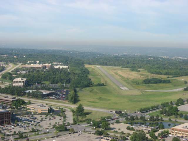
Photo: Nyttend, public domain · Wikimedia Commons
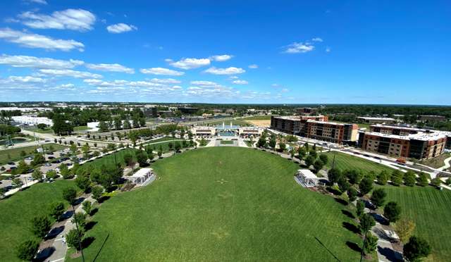
Photo: Blue Ash Communications, CC BY-SA 4.0 · Wikimedia Commons
Local history sources: en.wikipedia.org · en.wikipedia.org · commons.wikimedia.org · commons.wikimedia.org
Water
Ohio River intake at the plant's riverfront on Kellogg Ave in the California neighborhood, east Cincinnati The water here
- Cincinnati Public Water System90% of residentsOhio River (Miller Plant, ~88%) plus Great Miami Buried Valley Aquifer wells (~12%)
- Butler Co. Water District 26% of residentsHamilton wells (Great Miami aquifer) + Cincinnati (Ohio River + wells)
- Indian Hill City3% of residentsLittle Miami River valley aquifer (wells near Milford)
- Reading City0% of residentsOhio River (Miller Plant, ~88%) plus Great Miami Buried Valley Aquifer wells (~12%)
Hospitals, fire stations and more
Inside Blue Ash's boundary: 1 hospital, 1 dialysis center, 1 nursing home, 2 fire and EMS stations, 1 college, 3 public schools, 1 private school, 1 library, 1 museum, 1 police station, 3 public charging sites, 29 Toxics Release Inventory facilities and 13 spill cases. Press a pin or a name for its whole record and its source.
Hospitals (1)
-
Cincinnati Rehabilitation HospitalRehabilitation hospital · Blue Ash
- What it is
- Rehabilitation hospital
- Address
- 4291 Parkview Drive, Blue Ash, OH 44060
- County
- Hamilton County
- Beds
- 40
- Ownership
- Proprietary
- Phone
- (513) 788-3313
Where HIFLD got this record ↗ HIFLD hospitals (source) ↗ Street map and directions ↗
Source: HIFLD hospitals inventory via FEMA (closed hospitals it still lists left out, hospitals opened since added), with Medicare Care Compare ratings matched by name and address.
Dialysis centers (1)
-
Davita Blue Ash DialysisDialysis · Blue Ash
- Address
- 10600 Mckinley Road, Blue Ash, OH 45242
- Dialysis stations
- 18
- Medicare star rating
- 2 of 5 stars
- Services
- in-center hemodialysis
- Ownership
- for profit
- Chain
- DaVita
- Medicare certified since
- 1991-02-25
- Phone
- (513) 733-8215
- Medicare ID
- 362519
Medicare Care Compare ↗ CMS dialysis facility list (source) ↗ Street map and directions ↗
Source: CMS dialysis facility list, September 2026, geocoded with the Census Bureau batch geocoder (an address it could not place sits at its ZIP center).
Nursing homes (1)
-
Blue Ash Health & Rehab1 of 5 stars · Cincinnati
- Address
- 4900 Cooper Road, Cincinnati, OH 45242
- Certified beds
- 64
- Residents on an average day
- 38
- Medicare overall rating
- 1 of 5 stars
- Health inspections
- 2 of 5 stars
- Staffing
- 1 of 5 stars
- Quality measures
- 4 of 5 stars
- Penalties since 2023
- none
- Ownership
- For profit - Corporation
- Chain
- BAO OPCO HOLDINGS
- Takes
- Medicare and Medicaid
- Phone
- (513) 793-3362
- Medicare ID
- 365218
Medicare Care Compare ↗ CMS nursing home data (source) ↗ Street map and directions ↗
Source: CMS Care Compare nursing home provider and penalties files; Medicare star ratings run 1 to 5.
Fire and EMS stations (2)
-
Blue Ash Fire Department Station 13 North StationBlue Ash
- Address
- 10647 Kenwood Road, Blue Ash, OH 45242
- Coordinates
- 39.25639, -84.37537
USGS National Map structures (source) ↗ Street map and directions ↗
-
Blue Ash Fire Department Station 15 South StationBlue Ash
- Address
- 4343 Cooper Road, Blue Ash, OH 45242
- Coordinates
- 39.23605, -84.38894
USGS National Map structures (source) ↗ Street map and directions ↗
Source: USGS National Map structures (most Ohio records last updated 2019 to 2022), checked against the Columbus and Cleveland station lists. The department that answers a call is set by jurisdiction and mutual aid, not by distance.
Colleges (1)
-
University of Cincinnati-Blue Ash CollegeRegional campus of a public university · Blue Ash
- What it is
- Regional campus of a public university
- City
- Blue Ash
- Students, 2023-24 (12-month count)
- 11,621
- Tuition and fees, in state
- $6,992
- Tuition and fees, out of state
- $15,790
- Graduation rate
- 15% (all programs, within 150% of normal time) (a class of 1,235)
- IPEDS unit ID
- 201955
College Navigator (NCES) ↗ IPEDS data (source) ↗ Street map and directions ↗
Source: NCES IPEDS 2024 directory, 2023-24 enrollment and tuition, graduation rates for the 2017 (four-year) and 2020 (two-year) entering classes.
Public schools (3)
-
Blue Ash Elementary4.5 of 5 stars · Cincinnati
- Address
- 9541 Plainfield Rd, Cincinnati, OH 45236
- School district
- Sycamore Community City School District
- Kind (NCES)
- Regular School
- Students, 2023-24
- 618
- Teachers (full-time equivalent)
- 33
- Report card, 2025-26
- 4.5 of 5 stars
- Performance index
- 94.9%
- Ohio building IRN
- 002998
- NCES school ID
- 390448601737
NCES school record ↗ Ohio School Report Card ↗ Street map and directions ↗
-
Edwin H Greene Intermediate Middle School4.5 of 5 stars · Cincinnati
- Address
- 5200 Aldine Dr, Cincinnati, OH 45242
- School district
- Sycamore Community City School District
- Kind (NCES)
- Regular School
- Students, 2023-24
- 943
- Teachers (full-time equivalent)
- 50.81
- Report card, 2025-26
- 4.5 of 5 stars
- Performance index
- 94.4%
- Ohio building IRN
- 036657
- NCES school ID
- 390448601738
NCES school record ↗ Ohio School Report Card ↗ Street map and directions ↗
-
Maple Dale Elementary School5 of 5 stars · Cincinnati
- Address
- 6100 Hagewa Dr, Cincinnati, OH 45242
- School district
- Sycamore Community City School District
- Kind (NCES)
- Regular School
- Students, 2023-24
- 582
- Teachers (full-time equivalent)
- 32
- Report card, 2025-26
- 5 of 5 stars
- Performance index
- 99.3%
- Ohio building IRN
- 022525
- NCES school ID
- 390448601739
NCES school record ↗ Ohio School Report Card ↗ Street map and directions ↗
Source: NCES EDGE public school locations 2024-25 and Common Core of Data 2023-24 (type, students, teachers); Ohio School Report Cards 2025-26 (Department of Education and Workforce), matched by name within the district.
Private schools (1)
-
Ursuline Academy of CincinnatiPrivate, Catholic · Cincinnati
- Address
- 5535 Pfeiffer Rd, Cincinnati, OH 45242
- Kind
- Catholic
- Students, 2023-24
- 483
- Teachers (full-time equivalent)
- 43.3
- Students per teacher
- 11.1547
- Phone
- (513) 791-5791
- NCES private school ID
- 01055682
Source: NCES Private School Survey 2023-24.
Public libraries (1)
-
Blue AshBranch · Blue Ash
- Address
- 4911 Cooper Rd., Blue Ash, OH 45242
- What it is
- Branch
- Library system
- Cincinnati and Hamilton County Public Library
- Open
- 3,120 hours a year, 52 weeks
- Building
- 12,280 sq ft
- System's visits, FY2024
- 4,091,256
- System's loans, FY2024
- 20,126,186
- People the system serves
- 830,639
- Phone
- (513) 369-6051
IMLS Public Libraries Survey (source) ↗ Street map and directions ↗
Source: IMLS Public Libraries Survey FY2024 (outlets and their systems). Any Ohio resident can get a free card at any Ohio public library.
Museums, historical societies, gardens and zoos (1)
-
University Of CincinnatiS Blue Ash Art GalleryArt museum · Blue Ash
- What it is
- Art museum
- City
- Blue Ash
- Coordinates
- 39.23781, -84.39567
Search Wikipedia ↗ IMLS Museum Data Files (source) ↗ Street map and directions ↗
The museum list is IMLS's 2018 file; a museum may have closed or moved since.
Source: IMLS Museum Data Files, 2018.
Police stations (1)
-
Blue Ash Police DepartmentBlue Ash
- Address
- 4343 Cooper Road, Blue Ash, OH 45242
- Coordinates
- 39.23652, -84.38913
USGS National Map structures (source) ↗ Street map and directions ↗
Source: USGS National Map structures, police stations, corrected and completed by hand (September 2026). The department that answers a call is set by jurisdiction, not by distance.
Public EV charging (3)
-
49 Hundred Apartments10 Level 2 · Blue Ash
- Address
- 4900 Hunt Road, Blue Ash, OH 45242
- Ports
- 10 Level 2
- Plugs
- J1772
- Network
- FLO
- Hours
- 24 hours daily
- Phone
- 888-356-8911
Station Locator (NREL) ↗ Alternative Fuels Data Center (source) ↗ Street map and directions ↗
-
Envision Cinemas Bar & Grille - Tesla Destination2 Level 2 · Cincinnati
- Address
- 4780 Cornell Rd, Cincinnati, OH 45241
- Ports
- 2 Level 2
- Plugs
- Tesla (NACS)
- Network
- Tesla Destination
- Phone
- 877-798-3752
Station Locator (NREL) ↗ Alternative Fuels Data Center (source) ↗ Street map and directions ↗
-
Wingate by Wyndham Cincinnati-Blue Ash - Tesla Destination2 Level 2 · Blue Ash
- Address
- 4320 Glendale Milford Rd, Blue Ash, OH 45242
- Ports
- 2 Level 2
- Plugs
- Tesla (NACS)
- Network
- Tesla Destination
- Phone
- 877-798-3752
Station Locator (NREL) ↗ Alternative Fuels Data Center (source) ↗ Street map and directions ↗
Source: NREL Alternative Fuels Data Center station list (May 2026), public and open stations, the posts at one address counted as one site.
Facilities reporting toxic releases (29)
-
Blue Ash Industrial ParkToxics Release Inventory · Cincinnati
- Address
- 11093 Kenwood Rd, Cincinnati, OH 45242
- County
- Hamilton County
- Status
- Reports to the Toxics Release Inventory (active)
- EPA program ID
- 4524WTRGXX1193K
- EPA registry ID
- 110039587257
EPA facility record ↗ EPA Facility Registry Service (source) ↗ Street map and directions ↗
-
Cincinati Thermal SprayToxics Release Inventory · Cincinnati
- Address
- 5901 Creek Rd, Cincinnati, OH 45242
- County
- Hamilton County
- Status
- Reports to the Toxics Release Inventory (active)
- EPA program ID
- 45242CNCNN5901C
- EPA registry ID
- 110002113374
EPA facility record ↗ EPA Facility Registry Service (source) ↗ Street map and directions ↗
-
Deluxe Check Printers IncToxics Release Inventory · Blue Ash
- Address
- 9875 Redhill Dr., Blue Ash, OH 45242
- County
- Hamilton County
- Status
- Reports to the Toxics Release Inventory (closed)
- EPA program ID
- 45242DLXCH9875R
- EPA registry ID
- 110002113392
EPA facility record ↗ EPA Facility Registry Service (source) ↗ Street map and directions ↗
-
Ethicon Endo-Surgery IncToxics Release Inventory · Cincinnati
- Address
- 4545 Creek Rd., Cincinnati, OH 45242
- County
- Hamilton County
- Status
- Reports to the Toxics Release Inventory (active)
- EPA program ID
- 45242THCNN4545C
- EPA registry ID
- 110000393832
EPA facility record ↗ EPA Facility Registry Service (source) ↗ Street map and directions ↗
-
Feintool Cincinnati IncToxics Release Inventory · Cincinnati
- Address
- 5565 Creek Rd., Cincinnati, OH 45242
- County
- Hamilton County
- Status
- Reports to the Toxics Release Inventory (active)
- EPA program ID
- 45242FNTLC5565C
- EPA registry ID
- 110000747041
EPA facility record ↗ EPA Facility Registry Service (source) ↗ Street map and directions ↗
-
Feintool Cincinnati IncToxics Release Inventory · Cincinnati
- Address
- 11280 Cornell Park Dr., Cincinnati, OH 45242
- County
- Hamilton County
- Status
- Reports to the Toxics Release Inventory (active)
- EPA program ID
- 45242FNTLC11280
- EPA registry ID
- 110000393770
EPA facility record ↗ EPA Facility Registry Service (source) ↗ Street map and directions ↗
-
Go/Dan IndustriesToxics Release Inventory · Blue Ash
- Address
- 10852 Millington Ct, Blue Ash, OH 45242
- County
- Hamilton County
- Status
- Reports to the Toxics Release Inventory (active)
- EPA program ID
- 45242MNGMM10852
- EPA registry ID
- 110002113409
EPA facility record ↗ EPA Facility Registry Service (source) ↗ Street map and directions ↗
-
Hb Fuller CoToxics Release Inventory · Blue Ash
- Address
- 4440 Malsbury Road, Blue Ash, OH 45242
- County
- Hamilton County
- Status
- Reports to the Toxics Release Inventory (active)
- EPA program ID
- 45242HBFLL4440M
- EPA registry ID
- 110000393789
EPA facility record ↗ EPA Facility Registry Service (source) ↗ Street map and directions ↗
-
Ingersoll-Rand Co Steelcraft DivToxics Release Inventory · Cincinnati
- Address
- 9017 Blue Ash Road, Cincinnati, OH 45242
- County
- Hamilton County
- Status
- Reports to the Toxics Release Inventory (active)
- EPA program ID
- 45242STLCR9017B
- EPA registry ID
- 110000393823
EPA facility record ↗ EPA Facility Registry Service (source) ↗ Street map and directions ↗
-
Itw Evercoat, A Division of Iiiinois Tool Works, Inc. (1431053385)Toxics Release Inventory · Blue Ash
- Address
- 6600 Cornell Road, Blue Ash, OH 45242
- County
- Hamilton County
- Status
- Reports to the Toxics Release Inventory (active)
- EPA program ID
- 45242FBRGL6600C
- EPA registry ID
- 110000393761
EPA facility record ↗ EPA Facility Registry Service (source) ↗ Street map and directions ↗
-
Itw VortecToxics Release Inventory · Cincinnati
- Address
- 10125 Carver Rd., Cincinnati, OH 45242
- County
- Hamilton County
- Status
- Reports to the Toxics Release Inventory (active)
- EPA program ID
- 45242TWVRT10125
- EPA registry ID
- 110000393841
EPA facility record ↗ EPA Facility Registry Service (source) ↗ Street map and directions ↗
-
J W Harris Co IncToxics Release Inventory · Cincinnati
- Address
- 10930 Deerfield Road, Cincinnati, OH 45242
- County
- Hamilton County
- Status
- Reports to the Toxics Release Inventory (active)
- EPA program ID
- 45242JWHRR10930
- EPA registry ID
- 110013794894
EPA facility record ↗ EPA Facility Registry Service (source) ↗ Street map and directions ↗
-
Japlar Group Inc.Toxics Release Inventory · Cincinnati
- Address
- 4500 Alpine Ave., Cincinnati, OH 45242
- County
- Hamilton County
- Status
- Reports to the Toxics Release Inventory (active)
- EPA program ID
- 45242SCHRM4500A
- EPA registry ID
- 110002317029
EPA facility record ↗ EPA Facility Registry Service (source) ↗ Street map and directions ↗
-
Kroger Cincinnati Fresh CenterToxics Release Inventory · Cincinnati
- Address
- 6300 Creek Road, Cincinnati, OH 45202
- County
- Hamilton County
- Status
- Reports to the Toxics Release Inventory
- EPA program ID
- 4524WKRGRC63CRE
- EPA registry ID
- 110012534999
EPA facility record ↗ EPA Facility Registry Service (source) ↗ Street map and directions ↗
-
Legrand Avd (1431053380)Toxics Release Inventory · Cincinnati
- Address
- 11500 Williamson Road, Cincinnati, OH 45241
- County
- Hamilton County
- Status
- Reports to the Toxics Release Inventory (active)
- EPA program ID
- 45241DLTSC11500
- EPA registry ID
- 110000393716
EPA facility record ↗ EPA Facility Registry Service (source) ↗ Street map and directions ↗
-
Lighting Systems IncToxics Release Inventory · Cincinnati
- Address
- 10170 Alliance Road, Cincinnati, OH 45242
- County
- Hamilton County
- Status
- Reports to the Toxics Release Inventory (active)
- EPA program ID
- 45242LGHTN10170
- EPA registry ID
- 110001129760
EPA facility record ↗ EPA Facility Registry Service (source) ↗ Street map and directions ↗
-
Maverick Molding Co. (1431054102)Toxics Release Inventory · Blue Ash
- Address
- 11379 Grooms Rd, Blue Ash, OH 45242
- County
- Hamilton County
- Status
- Reports to the Toxics Release Inventory (active)
- EPA program ID
- 4524WMVRCK11379
- EPA registry ID
- 110012251384
EPA facility record ↗ EPA Facility Registry Service (source) ↗ Street map and directions ↗
-
Michelman IncToxics Release Inventory · Cincinnati
- Address
- 9080 Shell Rd., Cincinnati, OH 45236
- County
- Hamilton County
- Status
- Reports to the Toxics Release Inventory
- EPA program ID
- 45236MCHLM9089S
- EPA registry ID
- 110064365725
EPA facility record ↗ EPA Facility Registry Service (source) ↗ Street map and directions ↗
-
Perma DoorToxics Release Inventory · Blue Ash
- Address
- 4300 Glendale-Milford Road, Blue Ash, OH 45242
- County
- Hamilton County
- Status
- Reports to the Toxics Release Inventory (active)
- EPA program ID
- 45242PRMDR4300G
- EPA registry ID
- 110001626651
EPA facility record ↗ EPA Facility Registry Service (source) ↗ Street map and directions ↗
-
Superalloy Manufacturing Solutions CorporationToxics Release Inventory · Cincinnati
- Address
- 11495 Deerfield Rd, Cincinnati, OH 45242
- County
- Hamilton County
- Status
- Reports to the Toxics Release Inventory (active)
- EPA program ID
- 45242SRMTC11495
- EPA registry ID
- 110000393814
EPA facility record ↗ EPA Facility Registry Service (source) ↗ Street map and directions ↗
-
Superalloy Manufacturing Solutions CorporationToxics Release Inventory · Cincinnati
- Address
- 11230 Deerfield Rd, Cincinnati, OH 45242
- County
- Hamilton County
- Status
- Reports to the Toxics Release Inventory (active)
- EPA program ID
- 45242LHRPR11230
- EPA registry ID
- 110000393805
EPA facility record ↗ EPA Facility Registry Service (source) ↗ Street map and directions ↗
-
Superior Label Systems, Inc.Toxics Release Inventory · Cincinnati
- Address
- 11405 Grooms Road, Cincinnati, OH 45242
- County
- Hamilton County
- Status
- Reports to the Toxics Release Inventory (active)
- EPA program ID
- 45242SPRRL11405
- EPA registry ID
- 110000840289
EPA facility record ↗ EPA Facility Registry Service (source) ↗ Street map and directions ↗
-
Trans-Acc (1431050909)Toxics Release Inventory · Cincinnati
- Address
- 11167 Deerfield Rd., Cincinnati, OH 45242
- County
- Hamilton County
- Status
- Reports to the Toxics Release Inventory (active)
- EPA program ID
- 45242TRNSC11167
- EPA registry ID
- 110002113436
EPA facility record ↗ EPA Facility Registry Service (source) ↗ Street map and directions ↗
-
Vibra Finish CoToxics Release Inventory · Cincinnati
- Address
- 11314 Tamarco Rd, Cincinnati, OH 45242
- County
- Hamilton County
- Status
- Reports to the Toxics Release Inventory (closed)
- EPA program ID
- 45242VBRFN11314
- EPA registry ID
- 110002113445
EPA facility record ↗ EPA Facility Registry Service (source) ↗ Street map and directions ↗
-
Vickers WelcoToxics Release Inventory · Cincinnati
- Address
- 9027 Shell Road, Cincinnati, OH 45236
- County
- Hamilton County
- Status
- Reports to the Toxics Release Inventory (active)
- EPA program ID
- 45236VCKRS9027S
- EPA registry ID
- 110002113258
EPA facility record ↗ EPA Facility Registry Service (source) ↗ Street map and directions ↗
-
Westrock Cp, LlcToxics Release Inventory · Cincinnati
- Address
- 9960 Alliance Road, Cincinnati, OH 45242
- County
- Hamilton County
- Status
- Reports to the Toxics Release Inventory (active)
- EPA program ID
- 45242CNTNR9960A
- EPA registry ID
- 110009657978
EPA facility record ↗ EPA Facility Registry Service (source) ↗ Street map and directions ↗
-
Wincom IncToxics Release Inventory · Cincinnati
- Address
- 11444 Deerfield Rd, Cincinnati, OH 45242
- County
- Hamilton County County
- Status
- Reports to the Toxics Release Inventory
- EPA program ID
- 4524WWNCMN11444
- EPA registry ID
- 110070684820
EPA facility record ↗ EPA Facility Registry Service (source) ↗ Street map and directions ↗
-
Wornick Prepared Food Co-ManufacturerToxics Release Inventory · Blue Ash
- Address
- 10825 Kenwood Road, Blue Ash, OH 45242
- County
- Hamilton County
- Status
- Reports to the Toxics Release Inventory (active)
- EPA program ID
- 4524WWRNCK1825K
- EPA registry ID
- 110009605668
EPA facility record ↗ EPA Facility Registry Service (source) ↗ Street map and directions ↗
-
Xomox Pft CorpToxics Release Inventory · Cincinnati
- Address
- 4444 Cooper Rd, Cincinnati, OH 45242
- County
- Hamilton County
- Status
- Reports to the Toxics Release Inventory (active)
- EPA program ID
- 45242XMXCR4444C
- EPA registry ID
- 110000393850
EPA facility record ↗ EPA Facility Registry Service (source) ↗ Street map and directions ↗
Source: EPA Facility Registry Service, Toxics Release Inventory reporters. Reporting a release is required of large users of listed chemicals; it is not by itself a violation.
Spills reported since 2021 (13)
-
Fuel Diesel / Diesel Fuel (Vehicle On Or Off Road)2025-06-19 · Blue Ash
- Reported
- 2025-06-19
- What spilled
- Fuel Diesel / Diesel Fuel (Vehicle On Or Off Road)
- Largest amount reported
- 100 gallons
- Where
- Blue Ash, Hamilton County
- Ohio EPA district office
- SWDO
- Ohio EPA case number
- 2506EPA0001011
Ohio EPA spill reports (source) ↗ Street map and directions ↗
-
Mercury / Quicksilver (Hg)2024-12-17 · Blue Ash
- Reported
- 2024-12-17
- What spilled
- Mercury / Quicksilver (Hg)
- Where
- Blue Ash, Hamilton County
- Ohio EPA district office
- SWDO
- Ohio EPA case number
- 2412EPA0002030
Ohio EPA spill reports (source) ↗ Street map and directions ↗
-
Fuel Diesel / Diesel Fuel (Vehicle On Or Off Road)2024-11-06 · Blue Ash
- Reported
- 2024-11-06
- What spilled
- Fuel Diesel / Diesel Fuel (Vehicle On Or Off Road)
- Largest amount reported
- 150 gallons
- Where
- Blue Ash, Hamilton County
- Ohio EPA district office
- SWDO
- Ohio EPA case number
- 2411EPA0001841
Ohio EPA spill reports (source) ↗ Street map and directions ↗
-
Fuel Diesel / Diesel Fuel (Vehicle On Or Off Road)2024-07-17 · Blue Ash
- Reported
- 2024-07-17
- What spilled
- Fuel Diesel / Diesel Fuel (Vehicle On Or Off Road)
- Largest amount reported
- 100 gallons
- Where
- Blue Ash, Hamilton County
- Ohio EPA district office
- SWDO
- Ohio EPA case number
- 2407EPA0001211
Ohio EPA spill reports (source) ↗ Street map and directions ↗
-
Oil Petroleum Not Otherwise Specified (Nos)2024-01-09 · Blue Ash
- Reported
- 2024-01-09
- What spilled
- Oil Petroleum Not Otherwise Specified (Nos)
- Where
- Blue Ash, Hamilton County
- Ohio EPA district office
- SWDO
- Ohio EPA case number
- 2401EPA0000051
Ohio EPA spill reports (source) ↗ Street map and directions ↗
-
Material Green Reached water2022-08-08 · Blue Ash
- Reported
- 2022-08-08
- What spilled
- Material Green
- Reached a waterway
- 99 - Unnamed
- Where
- Blue Ash, Hamilton County
- Ohio EPA district office
- SWDO
- Ohio EPA case number
- 2208EPA0001195
Ohio EPA spill reports (source) ↗ Street map and directions ↗
-
Other / All Other / Trade Name / Mixture / Solution Etc Reached water2022-01-24 · Blue Ash
- Reported
- 2022-01-24
- What spilled
- Other / All Other / Trade Name / Mixture / Solution Etc
- Largest amount reported
- 1 gallons
- Reached a waterway
- 99 - Unnamed
- Where
- Blue Ash, Hamilton County
- Ohio EPA district office
- SWDO
- Ohio EPA case number
- 2201EPA0000071
Ohio EPA spill reports (source) ↗ Street map and directions ↗
-
Fuel Diesel / Diesel Fuel (Vehicle On Or Off Road)2022-01-20 · Blue Ash
- Reported
- 2022-01-20
- What spilled
- Fuel Diesel / Diesel Fuel (Vehicle On Or Off Road)
- Largest amount reported
- 30 gallons
- Where
- Blue Ash, Hamilton County
- Ohio EPA district office
- SWDO
- Ohio EPA case number
- 2201EPA0000061
Ohio EPA spill reports (source) ↗ Street map and directions ↗
-
Other / All Other / Trade Name / Mixture / Solution Etc2021-07-19 · Blue Ash
- Reported
- 2021-07-19
- What spilled
- Other / All Other / Trade Name / Mixture / Solution Etc
- Where
- Blue Ash, Hamilton County
- Ohio EPA district office
- SWDO
- Ohio EPA case number
- 2107EPA0001088
Ohio EPA spill reports (source) ↗ Street map and directions ↗
-
Anhydrous Ammonia (Nh3)2021-04-06 · Blue Ash
- Reported
- 2021-04-06
- What spilled
- Anhydrous Ammonia (Nh3); Other / All Other / Trade Name / Mixture / Solution Etc
- Largest amount reported
- 150 gallons
- Where
- Blue Ash, Hamilton County
- Ohio EPA district office
- SWDO
- Ohio EPA case number
- 2104EPA0000464
Ohio EPA spill reports (source) ↗ Street map and directions ↗
-
Antifreeze Vehicle Cooling Reached water2026-09-02 · Blue Ash
- Reported
- 2026-09-02
- What spilled
- Antifreeze Vehicle Cooling
- Reached a waterway
- 99 - Unnamed
- Where
- Blue Ash, Hamilton County
- Ohio EPA district office
- SWDO
- Ohio EPA case number
- 2609EPA0001643
Ohio EPA spill reports (source) ↗ Street map and directions ↗
-
Propylene Glycol (C3H8O2)2026-05-27 · Blue Ash
- Reported
- 2026-05-27
- What spilled
- Propylene Glycol (C3H8O2)
- Largest amount reported
- 800 gallons
- Where
- Blue Ash, Hamilton County
- Ohio EPA district office
- SWDO
- Ohio EPA case number
- 2605EPA0000912
Ohio EPA spill reports (source) ↗ Street map and directions ↗
-
Contaminated Water2026-05-18 · Blue Ash
- Reported
- 2026-05-18
- What spilled
- Contaminated Water
- Largest amount reported
- 1,000 gallons
- Where
- Blue Ash, Hamilton County
- Ohio EPA district office
- SWDO
- Ohio EPA case number
- 2605EPA0000835
Ohio EPA spill reports (source) ↗ Street map and directions ↗
Source: Ohio EPA emergency response spill reports, 2021 to September 2026, one point per case where Ohio EPA placed it. A report is what the caller or responder recorded; amounts are often blank or estimated.
Its ZIP codes
Each ZIP code that touches Blue Ash, with the share of its residents who live here and the same headline figures as the ZIP page.
| ZIP | Share | Water | Radon | Home value | Schools | Flood |
|---|---|---|---|---|---|---|
| 45242 Blue Ash and Cincinnati | 38% | Ohio River intake at the plant's riverfront on Kellogg Ave in the California neighborhood, east Cincinnati | 3.4 pCi/L average radon | Median year built 1973 | Sycamore Community City · 5 stars overall | 0.0% of residents in the 1% floodplain |
| 45241 Sharonville and Cincinnati | 12% | Ohio River intake at the plant's riverfront on Kellogg Ave in the California neighborhood, east Cincinnati | 3.5 pCi/L average radon | Median year built 1981 | Princeton City · 4 stars overall | 2.8% of residents in the 1% floodplain |
| 45236 Sycamore Township and Cincinnati | 7% | Ohio River intake at the plant's riverfront on Kellogg Ave in the California neighborhood, east Cincinnati | 2.6 pCi/L average radon | Median year built 1951 | Deer Park Community City · 4 stars overall | 0.0% of residents in the 1% floodplain |
Local government
Who holds office in Blue Ash, how its elections and ballot issues came out, and the state auditor's record.
Elections for office
| Date | Office | Candidates and votes |
|---|---|---|
| 2025-11-04 | Member of Council at Large (A) | Jim Friend 2,294, 62.49%; Lee E. Czerwonka 1,377, 37.51% |
| 2025-11-04 | Member of Council (4th Ward) | Jeff Capell 451, 68.33%; Cheryl Blakeman 209, 31.67% |
| 2025-11-04 | Member of Council (2nd Ward) | Brian David Gath 668, 100.0% |
| 2023-11-07 | Member of Council at Large (B) | Jill Cole 4,085, 100.0% |
| 2023-11-07 | Member of Council (5th Ward) | Marc Sirkin 919, 100.0% |
| 2023-11-07 | Member of Council (3rd Ward) | Pramod Jhaveri 533, 53.09%; Joe Hoelker 471, 46.91% |
| 2023-11-07 | Member of Council (1st Ward) | Kathryn E. Schneider 709, 100.0% |
| 2021-11-02 | Member of Council at Large (B) (Unexpired term ending 11-30-2023) | Jill Cole 2,335, 100.0% |
| 2021-11-02 | Member of Council at Large (A) | Lee E. Czerwonka 1,912, 57.04%; Robert R. Ryan 1,440, 42.96% |
| 2021-11-02 | Member of Council (4th Ward) | Jeff Capell 425, 100.0% |
| 2021-11-02 | Member of Council (2nd Ward) | Brian Gath 545, 57.43%; Joe Leet 404, 42.57% |
Winners in bold. Results from the county board of elections' official canvass unless marked.
Auditor of State record
- No fiscal caution, watch or emergency on the Auditor of State's lists.
- Financial Health Indicators (the Auditor of State's 17 measures; critical / cautionary / positive): 2020 0 / 1 / 16; 2021 0 / 1 / 16; 2022 0 / 1 / 16; 2023 0 / 0 / 17; 2024 0 / 3 / 14; 2025 0 / 0 / 16.
- OP&F Examination, 2024, released 2026-05-07
- Financial Audit, 2024, released 2025-09-25
The county
Hamilton County: 54 ZIP codes, 47 cities, villages and townships, 843,791 people.
Nearby places
Rain and snow
How much has actually fallen on Blue Ash, day by day, from 1893 to now. Daily totals, not averages.
- rain, last 30 days
- 1.14 in
- 2026-09-30 to 2026-10-29
- rain so far in 2026
- 45.6 in
- 5.7 in above normal for the date
- snow so far in 2026
- 13.0 in
- a normal year brings 17.3 in
- a normal year
- 47.1 in
- average of 30 years, 1991-2020
| Month | Rain (in) | Snow (in) | Days counted |
|---|---|---|---|
| October 2026 | 1.14 | — | 29 |
| September 2026 | 6.80 | — | 30 |
| August 2026 | 5.86 | — | 31 |
| July 2026 | 5.13 | — | 31 |
| June 2026 | 6.15 | — | 30 |
| May 2026 | 6.94 | — | 31 |
| April 2026 | 3.87 | — | 30 |
| March 2026 | 6.78 | 0.0 | 31 |
| February 2026 | 1.24 | 4.0 | 28 |
| January 2026 | 1.65 | 8.9 | 31 |
| December 2025 | 2.59 | 10.7 | 31 |
| November 2025 | 3.90 | 1.8 | 30 |
| Wettest year | 2011 — 74.9 in |
|---|---|
| Driest year | 1934 — 21.7 in |
| Snowiest year | 2010 — 47.6 in |
| Wettest day on record | 5 March 1897 — 4.79 in |
| Heaviest snowfall in a day | 23 December 2004 — 12.52 in |
| Deepest snow on the ground | 20 December 1919 — 15.69 in |
Estimated, not measured. No rain gauge has ever stood inside Blue Ash, so every figure here is worked out from the gauges around it - the nearest ones weighted most. Treat them as close estimates rather than readings.
48,118 days of records, 1893-01-01 to 2026-10-29. Source: NOAA NCEI GHCN-Daily, 3,240 gauges in and around Ohio. A day is "gauged" when a gauge standing inside the boundary reported it, and the value is the mean of those gauges. Otherwise it is interpolated by inverse distance from every gauge reporting within 50 miles. Nothing is carried forward, back-filled or smoothed. Against NOAA nClimDiv county monthly precipitation over 136,848 complete county-months (checked 2026-10-31): correlation 0.9515, median absolute difference 0.217 in a month. Built 2026-10-31 from the Cracked Buckeye precipitation archive. Snow is the softer number — snowfall is measured by hand with a ruler, no agency publishes a gridded county snowfall series, and blowing snow defeats every observer.
Environmental permits and filings
What Ohio EPA has on file for Blue Ash: permits, inspections, violations, cleanups and the state loans behind sewer and water work. Every line links to the agency's own document.
- facilities and sites on file
- 114
- those placed on the map inside Blue Ash
| Program | Facilities and sites |
|---|---|
| Hazardous waste | 46 |
| Voluntary cleanup | 26 |
| Air pollution | 19 |
| Wastewater and stormwater discharge | 9 |
| Federal Facilities | 4 |
| Site assessment | 4 |
| Sewer and water-line construction | 2 |
| Composting | 1 |
| Contaminated-site cleanup | 1 |
| Landfills | 1 |
| Underground injection wells | 1 |
| Date | Facility or site | What |
|---|---|---|
| HARTZELL METHODIST CHURCH | Wastewater and stormwater discharge permit | |
| STEELCRAFT MFG CO | Air pollution permit | |
| STEELCRAFT MFG CO | Voluntary cleanup inspection | |
| FORMER AMERICAN LAUNDRY MACHINE CO. | Underground injection wells inspection | |
| FORMER AMERICAN LAUNDRY MACHINE CO. | Underground injection wells inspection | |
| FORMER AMERICAN LAUNDRY MACHINE CO. | Underground injection wells monitoring results | |
| 9617 KENWOOD RD DEVELOPMENT LLC | Voluntary cleanup inspection | |
| 9617 KENWOOD RD DEVELOPMENT LLC | Voluntary cleanup inspection | |
| RESILIENCE COLD STORAGE ADDITION | Wastewater and stormwater discharge permit | |
| MILESTONE AV TECHNOLOGIES LLC | Hazardous waste inspection | |
| H B FULLER CO | Voluntary cleanup inspection | |
| STEELCRAFT MFG CO | Voluntary cleanup inspection | |
| ITW EVERCOAT A DIVISION OF IIIINOIS TOOL WORKS INC | Air pollution permit | |
| STEELCRAFT MFG CO | Air pollution permit | |
| TRANS-ACC | Air pollution permit | |
| MAVERICK MOLDING CO | Air pollution notice of violation | |
| MILESTONE AV TECHNOLOGIES LLC | Air pollution notice of violation | |
| STEELCRAFT MFG CO | Air pollution permit | |
| TRANS-ACC INC | Air pollution permit | |
| BLUE ASH AIRPORT | Voluntary cleanup inspection | |
| TRANS-ACC | Air pollution permit | |
| OHIO VALLEY ELECTRICAL SERVICES | Wastewater and stormwater discharge permit | |
| SUPERALLOY MANUFACTURING SOLUTIONS CORPORATION | Hazardous waste inspection | |
| OHIO AIR NATL GUARD 123 TCF DE, BLUE ASH | Federal Facilities cleanup response | |
| METAL IMPROVEMENT CO | Air pollution report |
Source: Ohio EPA eDocument portal (edocpub.epa.ohio.gov), indexed 2026-10-14. Facilities are placed on the map from Ohio EPA's own map layers, EPA's Facility Registry, coordinates written in the filings, or a geocoded street address. A permit filed under a private person's name (most are household septic systems) is counted but never named, placed or linked; licenses for individual workers and open-burning notices are left out entirely.
Quick answers
What county is Blue Ash, Ohio in?
Blue Ash is a city in Hamilton County, Ohio, with 13,394 residents.
When was Blue Ash, Ohio founded?
Blue Ash was settled c. 1791; incorporated village, 1955; city, 1961. Source
How did Blue Ash, Ohio get its name?
The community took its name from the blue ash tree (Fraxinus quadrangulata), the wood the first settlers used in 1797 to build Carpenter's Run Baptist Church, the area's earliest structure. Source
What ZIP code is Blue Ash, Ohio?
Blue Ash is served by ZIP codes 45242, 45241 and 45236; 45242 holds the largest share of its residents.
Where does Blue Ash, Ohio get its water?
The main water source for Blue Ash (Cincinnati Public Water System): Ohio River intake at the plant's riverfront on Kellogg Ave in the California neighborhood, east Cincinnati.
Cite this page
Cite this page as:
Cracked Buckeye, "Blue Ash, Hamilton County", https://crackedbuckeye.com/place/blue-ash/, built 2026-10-31, accessed [date].
How to cite · Report a correction · Built 2026-10-31
