Local events in Sharonville
48 events in the next 90 days from 4 public calendars. All local events in Sharonville
Checked October 20; the events page is refreshed daily.
Deep dives about Sharonville
Long reads built from maps, newspapers and public records. All deep dives
How Sharonville began
Settlers reached the area that became Sharonville by 1788, building a farming community known simply as Sharon that stayed small for well over a century. An 1842 Greek Revival inn and tavern, the Twelve Mile House, survives from that early rural economy. Sharon incorporated as a village in 1911, when it still held under a thousand residents, and did not become a city until 1962; its real growth came after World War II, jumping from 1,318 residents in 1950 to 11,393 by 1970, a 765 percent increase, as the Cincinnati suburbs and interstate-era industry reached it. It adopted its own city flag, chosen by public contest, in August 1974, and by 2020 held 14,117 residents.
Settled 1788, incorporated village, 1911; city, 1962.
Where the name comes from
No source consulted explains the specific origin of the name "Sharon" (later Sharonville) for this community; it is a common American place name, often drawn from the fertile Plain of Sharon in the Biblical Levant.
Before the town
No Native village, mound, or documented encounter specific to Sharonville itself was found in the sources consulted.
Timeline
- — Settlers reach the area that becomes Sharon (later Sharonville).
- — The Twelve Mile House, an L-shaped, two-and-a-half-story Greek Revival inn and tavern, is built.
- — Sharon incorporates as a village.
- — Village population is 753.
- — Population is 1,318, still a small village on the eve of its postwar boom.
- — Sharonville becomes a city.
- — Population reaches 11,393, a 765 percent increase since 1950.
- — City council adopts an official city flag in August, chosen through a public design contest.
- — The Twelve Mile House is listed on the National Register of Historic Places on September 1.
- — Census population reaches 14,117.
Stories
Nine hundred percent in two decades
For more than a century and a half after its 1788 settlement, Sharon stayed what its name suggested: a small farming crossroads, still counting fewer than a thousand residents when it finally incorporated as a village in 1911. Its oldest surviving landmark, the Twelve Mile House, dates to 1842, an L-shaped Greek Revival tavern that took its name the old way, by distance -- a coach stop roughly twelve miles out from downtown Cincinnati. That slow pace held through two world wars; as late as 1950, the village held just 1,318 people. Then, in the space of two decades, everything changed: postwar highway construction, industrial parks, and Cincinnati's expanding suburbs found Sharonville almost all at once, and by 1970 its population had jumped to 11,393, a 765 percent increase in twenty years. The city marked its new identity in 1974 with something the old farming village never needed, a flag of its own, chosen by public contest -- a small piece of civic branding for a place that had spent most of its history being too small to need one.
Photographs
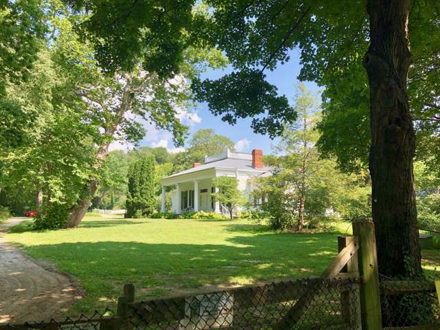
Photo: Warren LeMay, CC0 · Wikimedia Commons
Local history sources: en.wikipedia.org · en.wikipedia.org · en.wikipedia.org · commons.wikimedia.org
Historic places
1 place in Sharonville on the National Register of Historic Places. Press a pin or a name for its whole record.
-
Twelve Mile HouseBuilding · Sharonville · listed 1976
- Address
- 11006 Reading Rd.
- Where
- Sharonville, Hamilton County · ZIP 45241
- What it is
- Building
- Listed on the National Register
- 1976
- NRIS reference number
- 76001452
- Coordinates
- 39.26860, -84.41276
National Register file (NPS) ↗ Search Wikipedia ↗ Street map and directions ↗ On the Cracked Buckeye map
Source: National Park Service, National Register of Historic Places point file. The listing year is shown where NPS's certification date agrees with the listing's reference number. Listing recognizes significance; it does not restrict a private owner.
Water
Ohio River intake at the plant's riverfront on Kellogg Ave in the California neighborhood, east Cincinnati The water here
- Cincinnati Public Water System71% of residentsOhio River (Miller Plant, ~88%) plus Great Miami Buried Valley Aquifer wells (~12%)
- Butler Co. Water District 227% of residentsHamilton wells (Great Miami aquifer) + Cincinnati (Ohio River + wells)
- Glendale Village1% of residentsGroundwater wells (2 wells)
Hospitals, fire stations and more
Inside Sharonville's boundary: 2 nursing homes, 3 fire and EMS stations, 4 colleges, 2 high-hazard dams, 7 public schools, 2 private schools, 1 poor-rated bridge, 1 library, 2 museums, 1 police station, 3 public charging sites, 3 Superfund sites, 22 Toxics Release Inventory facilities, 1 station or terminal and 54 spill cases. Press a pin or a name for its whole record and its source.
Nursing homes (2)
-
Advanced Health Care of Cincinnati3 of 5 stars · Cincinnati
- Address
- 1400 Mallard Cove Drive, Cincinnati, OH 45246
- Certified beds
- 46
- Residents on an average day
- 41
- Medicare overall rating
- 3 of 5 stars
- Health inspections
- 3 of 5 stars
- Staffing
- 3 of 5 stars
- Quality measures
- 4 of 5 stars
- Penalties since 2023
- none
- Ownership
- For profit - Corporation
- Chain
- ADVANCED HEALTH CARE
- Takes
- Medicare and Medicaid
- Phone
- (513) 830-5014
- Medicare ID
- 366467
Medicare Care Compare ↗ CMS nursing home data (source) ↗ Street map and directions ↗
-
Cottingham Retirement Community3 of 5 stars · Cincinnati
- Address
- 3995 Cottingham Drive, Cincinnati, OH 45241
- Certified beds
- 60
- Residents on an average day
- 57
- Medicare overall rating
- 3 of 5 stars
- Health inspections
- 2 of 5 stars
- Staffing
- 2 of 5 stars
- Quality measures
- 5 of 5 stars
- Penalties since 2023
- none
- Ownership
- For profit - Limited Liability company
- Chain
- LIONSTONE CARE
- Continuing care retirement community
- Yes
- Takes
- Medicare and Medicaid
- Phone
- (513) 563-3600
- Medicare ID
- 365652
Medicare Care Compare ↗ CMS nursing home data (source) ↗ Street map and directions ↗
Source: CMS Care Compare nursing home provider and penalties files; Medicare star ratings run 1 to 5.
Fire and EMS stations (3)
-
Sharonville Fire Department Headquarters Station 86Cincinnati
- Address
- 11637 Chester Road, Cincinnati, OH 45246
- Coordinates
- 39.28675, -84.44454
USGS National Map structures (source) ↗ Street map and directions ↗
-
Sharonville Fire Department Station 87Sharonville
- Address
- 11210 Reading Road, Sharonville, OH 45241
- Coordinates
- 39.27307, -84.41105
USGS National Map structures (source) ↗ Street map and directions ↗
-
Sharonville Fire Department Station 88Sharonville
- Address
- 7150 Fields Ertel Road, Sharonville, OH 45241
- Coordinates
- 39.29337, -84.35893
USGS National Map structures (source) ↗ Street map and directions ↗
Source: USGS National Map structures (most Ohio records last updated 2019 to 2022), checked against the Columbus and Cleveland station lists. The department that answers a call is set by jurisdiction and mutual aid, not by distance.
Colleges (4)
-
Fortis College-CincinnatiFor-profit two-year college · Cincinnati
- What it is
- For-profit two-year college
- City
- Cincinnati
- Students, 2023-24 (12-month count)
- 662
- Tuition and fees, in state
- $14,283
- Graduation rate
- 41% within three years (a class of 289)
- IPEDS unit ID
- 450067
College Navigator (NCES) ↗ IPEDS data (source) ↗ Street map and directions ↗
-
Galen College of Nursing-CincinnatiFor-profit college · Cincinnati
- What it is
- For-profit college
- City
- Cincinnati
- Students, 2023-24 (12-month count)
- 890
- Tuition and fees, in state
- $16,400
- Graduation rate
- 55% (all programs, within 150% of normal time) (a class of 42)
- IPEDS unit ID
- 452948
College Navigator (NCES) ↗ IPEDS data (source) ↗ Street map and directions ↗
-
Great Oaks Career CampusesPublic career school · Cincinnati
- What it is
- Public career school
- City
- Cincinnati
- Students, 2023-24 (12-month count)
- 234
- IPEDS unit ID
- 202949
College Navigator (NCES) ↗ IPEDS data (source) ↗ Street map and directions ↗
-
Paul Mitchell the School-CincinnatiFor-profit career school · Cincinnati
- What it is
- For-profit career school
- City
- Cincinnati
- Students, 2023-24 (12-month count)
- 360
- IPEDS unit ID
- 455284
College Navigator (NCES) ↗ IPEDS data (source) ↗ Street map and directions ↗
Source: NCES IPEDS 2024 directory, 2023-24 enrollment and tuition, graduation rates for the 2017 (four-year) and 2020 (two-year) entering classes.
High-hazard dams (2)
-
Kreis DamSharon Creek · condition: fair
- Hazard class
- High: a failure would probably cost a life
- Condition
- Fair (assessed 05/20/2021)
- River or stream
- Sharon Creek
- Purpose
- Recreation
- Type
- Masonry
- Height
- 37 ft
- Storage
- 946 acre-feet
- Completed
- 1936
- Owner type
- Local Government
- County
- Hamilton County
- Nearest town (NID)
- Sharonville
- Last inspection
- 05/20/2021
- Emergency action plan
- Yes
- NID ID
- OH00191
National Inventory of Dams record ↗ National Inventory of Dams (source) ↗ Street map and directions ↗
-
Sharonville Retention DamTributary To Sharon Creek · condition: fair
- Hazard class
- High: a failure would probably cost a life
- Condition
- Fair (assessed 05/27/2021)
- River or stream
- Tributary To Sharon Creek
- Purpose
- Flood Risk Reduction
- Type
- Earth
- Height
- 46 ft
- Storage
- 256 acre-feet
- Completed
- 1967
- Owner type
- Local Government
- County
- Hamilton County
- Nearest town (NID)
- Sharonville
- Last inspection
- 05/27/2021
- Emergency action plan
- Yes
- NID ID
- OH00991
National Inventory of Dams record ↗ National Inventory of Dams (source) ↗ Street map and directions ↗
Source: U.S. Army Corps of Engineers National Inventory of Dams, August 2026. "High hazard" rates what a failure would cost downstream, not how likely one is; the condition is the state's assessment.
Public schools (7)
-
Instructional Resource CenterCincinnati
- Address
- 100 Scarlet Oaks Dr, Cincinnati, OH 45241
- Kind (NCES)
- Career and Technical School
- Students, 2023-24
- 30
- Teachers (full-time equivalent)
- 100.42
- NCES school ID
- 390510605846
-
Princeton Community Middle School3.5 of 5 stars · Cincinnati
- Address
- 200 Viking Way, Cincinnati, OH 45246
- School district
- Princeton City School District
- Kind (NCES)
- Regular School
- Students, 2023-24
- 1,318
- Teachers (full-time equivalent)
- 75
- Report card, 2025-26
- 3.5 of 5 stars
- Performance index
- 69%
- Ohio building IRN
- 030742
- NCES school ID
- 390446701553
NCES school record ↗ Ohio School Report Card ↗ Street map and directions ↗
-
Princeton High School5 of 5 stars · Cincinnati
- Address
- 100 Viking Way, Cincinnati, OH 45246
- School district
- Princeton City School District
- Kind (NCES)
- Regular School
- Students, 2023-24
- 1,691
- Teachers (full-time equivalent)
- 96.86
- Report card, 2025-26
- 5 of 5 stars
- Performance index
- 78.6%
- Four-year graduation rate
- 97.8%
- Ohio building IRN
- 030759
- NCES school ID
- 390446701554
NCES school record ↗ Ohio School Report Card ↗ Street map and directions ↗
-
Princeton Innovation Center2 of 5 stars · Cincinnati
- Address
- 3900 Cottingham Dr, Cincinnati, OH 45241
- School district
- Princeton City School District
- Kind (NCES)
- Regular School
- Students, 2023-24
- 300
- Teachers (full-time equivalent)
- 11
- Report card, 2025-26
- 2 of 5 stars
- Performance index
- 35.3%
- Four-year graduation rate
- 78.3%
- Ohio building IRN
- 017377
- NCES school ID
- 390446705967
NCES school record ↗ Ohio School Report Card ↗ Street map and directions ↗
-
Scarlet Oaks CdcCincinnati
- Address
- 300 Scarlet Oaks Dr, Cincinnati, OH 45241
- Kind (NCES)
- Career and Technical School
- Students, 2023-24
- 926
- Teachers (full-time equivalent)
- 60
- NCES school ID
- 390510604068
-
Sharonville Elementary School3 of 5 stars · Cincinnati
- Address
- 11150 Maple St, Cincinnati, OH 45241
- School district
- Princeton City School District
- Kind (NCES)
- Regular School
- Students, 2023-24
- 366
- Teachers (full-time equivalent)
- 25
- Report card, 2025-26
- 3 of 5 stars
- Performance index
- 70.1%
- Ohio building IRN
- 034157
- NCES school ID
- 390446701556
NCES school record ↗ Ohio School Report Card ↗ Street map and directions ↗
-
Stewart Elementary School3.5 of 5 stars · Cincinnati
- Address
- 11850 Conrey Rd, Cincinnati, OH 45249
- School district
- Princeton City School District
- Kind (NCES)
- Regular School
- Students, 2023-24
- 496
- Teachers (full-time equivalent)
- 27.5
- Report card, 2025-26
- 3.5 of 5 stars
- Performance index
- 67.2%
- Ohio building IRN
- 036087
- NCES school ID
- 390446701558
NCES school record ↗ Ohio School Report Card ↗ Street map and directions ↗
Source: NCES EDGE public school locations 2024-25 and Common Core of Data 2023-24 (type, students, teachers); Ohio School Report Cards 2025-26 (Department of Education and Workforce), matched by name within the district.
Private schools (2)
-
Park MontessoriPrivate, nonsectarian, special program · Cincinnati
- Address
- Po Box 62953, Cincinnati, OH 45262
- Kind
- nonsectarian, special program
- Students, 2023-24
- 8
- Teachers (full-time equivalent)
- 3.9
- Students per teacher
- 2.05128
- Phone
- (513) 563-7286
- NCES private school ID
- A0771460
-
St Michael Elementary SchoolPrivate, Catholic · Cincinnati
- Address
- 11136 Oak St, Cincinnati, OH 45241
- Kind
- Catholic
- Students, 2023-24
- 397
- Teachers (full-time equivalent)
- 22.9
- Students per teacher
- 17.3362
- Phone
- (513) 554-3555
- NCES private school ID
- 01056245
Source: NCES Private School Survey 2023-24.
Bridges rated poor (1)
-
I-75 over Tributary Mill CreekPoor · built 1960
- Condition
- Poor: a deck, superstructure, substructure or culvert rated 4 or below on the 0 to 9 scale
- What it is
- Culvert
- Built
- 1960
- Length
- 11 ft
- Owner
- State
- Vehicles a day
- 91,244
- Coordinates
- 39.29382, -84.44141
National Bridge Inventory (source) ↗ Street map and directions ↗
Source: FHWA National Bridge Inventory 2025. "Poor" means one major part rated 4 or below on the 0 to 9 scale; it calls for repair, not closing, unless the state posts or closes the bridge.
Public libraries (1)
-
SharonvilleBranch · Cincinnati
- Address
- 10980 Thornview Rd., Cincinnati, OH 45241
- What it is
- Branch
- Library system
- Cincinnati and Hamilton County Public Library
- Open
- 3,328 hours a year, 52 weeks
- Building
- 11,000 sq ft
- System's visits, FY2024
- 4,091,256
- System's loans, FY2024
- 20,126,186
- People the system serves
- 830,639
- Phone
- (513) 369-6049
IMLS Public Libraries Survey (source) ↗ Street map and directions ↗
Source: IMLS Public Libraries Survey FY2024 (outlets and their systems). Any Ohio resident can get a free card at any Ohio public library.
Museums, historical societies, gardens and zoos (2)
-
IspaceScience or technology museum · Cincinnati
- What it is
- Science or technology museum
- City
- Cincinnati
- Coordinates
- 39.28318, -84.40904
Search Wikipedia ↗ IMLS Museum Data Files (source) ↗ Street map and directions ↗
The museum list is IMLS's 2018 file; a museum may have closed or moved since.
-
United Methodist Historical Society Of OhioHistorical society · Sharonville
- What it is
- Historical society
- City
- Sharonville
- Coordinates
- 39.29359, -84.36341
Search Wikipedia ↗ IMLS Museum Data Files (source) ↗ Street map and directions ↗
The museum list is IMLS's 2018 file; a museum may have closed or moved since.
Source: IMLS Museum Data Files, 2018.
Police stations (1)
-
Sharonville Police DepartmentSharonville
- Address
- 10900 Reading Road, Sharonville, OH 45241
- Coordinates
- 39.26561, -84.41379
USGS National Map structures (source) ↗ Street map and directions ↗
Source: USGS National Map structures, police stations, corrected and completed by hand (September 2026). The department that answers a call is set by jurisdiction, not by distance.
Public EV charging (3)
-
Busam Motor Sales1 Level 2 · Cincinnati
- Address
- 1501 E Kemper Rd, Cincinnati, OH 45246
- Ports
- 1 Level 2
- Plugs
- J1772
- Network
- Non-Networked
- Hours
- Dealership business hours; must ask for charger to be turned on inside
- Price
- Free
- Phone
- 513-771-8100
Station Locator (NREL) ↗ Alternative Fuels Data Center (source) ↗ Street map and directions ↗
-
City of Sharonville4 Level 2 · Cincinnati
- Address
- 11325 Chester Rd, Cincinnati, OH 45246
- Ports
- 4 Level 2
- Plugs
- J1772
- Network
- AMPUP
- Hours
- Contact station for hours of availability
- Phone
- 513-563-0033
Station Locator (NREL) ↗ Alternative Fuels Data Center (source) ↗ Street map and directions ↗
-
LivINN Hotels - 11385 Chester Rd2 Level 2 · Sharonville
- Address
- 11385 Chester Rd, Sharonville, OH 45246
- Ports
- 2 Level 2
- Plugs
- J1772
- Network
- EV Connect
- Hours
- 24 hours daily
- Phone
- 866-816-7584
Station Locator (NREL) ↗ Alternative Fuels Data Center (source) ↗ Street map and directions ↗
Source: NREL Alternative Fuels Data Center station list (May 2026), public and open stations, the posts at one address counted as one site.
Superfund sites (3)
-
Bedinghaus Business FormsSuperfund program · Cincinnati
- Address
- 11417 Lippelman Rd, Cincinnati, OH 45246
- County
- Hamilton County
- Status
- Superfund program site, not on the National Priorities List
- EPA program ID
- OHD076771773
- EPA registry ID
- 110004622720
EPA facility record ↗ EPA Facility Registry Service (source) ↗ Street map and directions ↗
-
Green IndustriesSuperfund program · Cincinnati
- Address
- 3603 E Kemper Rd, Cincinnati, OH 45241
- County
- Hamilton County
- Status
- Superfund program site, not on the National Priorities List
- EPA program ID
- OHD004260709
- EPA registry ID
- 110000616986
EPA facility record ↗ EPA Facility Registry Service (source) ↗ Street map and directions ↗
-
Sharonville Mercury ResponseSuperfund program · West Chester
- Address
- 3055 East Crescentville Road, West Chester, OH 45069
- County
- Hamilton County
- Status
- Superfund program site, not on the National Priorities List
- EPA program ID
- OHN000510437
- EPA registry ID
- 110040752502
EPA facility record ↗ EPA Facility Registry Service (source) ↗ Street map and directions ↗
Source: EPA Facility Registry Service, Superfund (SEMS) and National Priorities List sites. Many program sites were assessed and needed no cleanup.
Facilities reporting toxic releases (22)
-
Astro Container CompanyToxics Release Inventory · Evendale
- Address
- 2795 E Sharon Rd, Evendale, OH 45241
- County
- Hamilton County
- Status
- Reports to the Toxics Release Inventory (active)
- EPA program ID
- 45241STRCN2795S
- EPA registry ID
- 110001625992
EPA facility record ↗ EPA Facility Registry Service (source) ↗ Street map and directions ↗
-
Cincinnati Industrial MachineryToxics Release Inventory · Cincinnati
- Address
- 3280 Hageman St., Cincinnati, OH 45241
- County
- Hamilton County
- Status
- Reports to the Toxics Release Inventory (active)
- EPA program ID
- 45241CNCNN3280H
- EPA registry ID
- 110002113301
EPA facility record ↗ EPA Facility Registry Service (source) ↗ Street map and directions ↗
-
Diversified Prods IncToxics Release Inventory · Cincinnati
- Address
- 11300 Jefferson, Cincinnati, OH 45241
- County
- Hamilton County
- Status
- Reports to the Toxics Release Inventory (closed)
- EPA program ID
- 45241DVRSF11300
- EPA registry ID
- 110001626795
EPA facility record ↗ EPA Facility Registry Service (source) ↗ Street map and directions ↗
-
Dubois ChemicalsToxics Release Inventory · Sharonville
- Address
- 3630 E Kemper Rd, Sharonville, OH 45241
- County
- Hamilton County
- Status
- Reports to the Toxics Release Inventory (active)
- EPA program ID
- 45241DBSCH3630E
- EPA registry ID
- 110000393707
EPA facility record ↗ EPA Facility Registry Service (source) ↗ Street map and directions ↗
-
Ei Ceramics Llc (1431404130)Toxics Release Inventory · Cincinnati
- Address
- 2600 Commerce Boulevard, Cincinnati, OH 45241
- County
- Hamilton County
- Status
- Reports to the Toxics Release Inventory (active)
- EPA program ID
- 45241CRMCS26CMM
- EPA registry ID
- 110017626112
EPA facility record ↗ EPA Facility Registry Service (source) ↗ Street map and directions ↗
-
Ford Motor Company (1431140861)Toxics Release Inventory · Sharonville
- Address
- 3000 Sharon Road, Sharonville, OH 45241
- County
- Hamilton County
- Status
- Reports to the Toxics Release Inventory (active)
- EPA program ID
- 45241FRDMT3000S
- EPA registry ID
- 110000498774
EPA facility record ↗ EPA Facility Registry Service (source) ↗ Street map and directions ↗
-
Forterra Pipe & Precast, Llc - CincinnatiToxics Release Inventory · West Chester
- Address
- 2930 E Cresentville Rd, West Chester, OH 45069
- County
- Butler County County
- Status
- Reports to the Toxics Release Inventory (closed)
- EPA program ID
- 45069HNSNC293EC
- EPA registry ID
- 110020518386
EPA facility record ↗ EPA Facility Registry Service (source) ↗ Street map and directions ↗
-
Gm Cereals Properties, Inc. (1431400175)Toxics Release Inventory · Cincinnati
- Address
- 11301 Mosteller Road, Cincinnati, OH 45241
- County
- Hamilton County
- Status
- Reports to the Toxics Release Inventory (***unchanged***)
- EPA program ID
- 4524WGMCRL1131M
- EPA registry ID
- 110009658405
EPA facility record ↗ EPA Facility Registry Service (source) ↗ Street map and directions ↗
-
Gorilla Glue Tri-CountyToxics Release Inventory · Cincinnati
- Address
- 2015 E Kemper Rd, Cincinnati, OH 45241
- County
- Hamilton County County
- Status
- Reports to the Toxics Release Inventory
- EPA program ID
- 4524WGRLLG215EK
- EPA registry ID
- 110069291475
EPA facility record ↗ EPA Facility Registry Service (source) ↗ Street map and directions ↗
-
Green IndustriesToxics Release Inventory · Cincinnati
- Address
- 3603 E Kemper Rd, Cincinnati, OH 45241
- County
- Hamilton County
- Status
- Reports to the Toxics Release Inventory (active)
- EPA program ID
- 45421GRNND3603E
- EPA registry ID
- 110000616986
EPA facility record ↗ EPA Facility Registry Service (source) ↗ Street map and directions ↗
-
Michelman, Inc.Toxics Release Inventory · Sharonville
- Address
- 3023 E Kemper Rd Buildings 2 & 3, Sharonville, OH 45241
- County
- Hamilton County
- Status
- Reports to the Toxics Release Inventory
- EPA program ID
- 45241MCHLM3023E
- EPA registry ID
- 110012705643
EPA facility record ↗ EPA Facility Registry Service (source) ↗ Street map and directions ↗
-
Pilot Chemical CompanyToxics Release Inventory · Cincinnati
- Address
- 2744 E Kemper Rd, Cincinnati, OH 45241
- County
- Hamilton County County
- Status
- Reports to the Toxics Release Inventory (***unchanged***)
- EPA program ID
- 4524WPLTCH2744E
- EPA registry ID
- 110071956453
EPA facility record ↗ EPA Facility Registry Service (source) ↗ Street map and directions ↗
-
Rjf Intl CorpToxics Release Inventory · Cincinnati
- Address
- 11310 Rockfield Ct., Cincinnati, OH 45241
- County
- Hamilton County
- Status
- Reports to the Toxics Release Inventory (active)
- EPA program ID
- 45241RJFNT11310
- EPA registry ID
- 110002113347
EPA facility record ↗ EPA Facility Registry Service (source) ↗ Street map and directions ↗
-
Safety-Kleen System - Sharonville FacilityToxics Release Inventory · Sharonville
- Address
- 11919 Tramway Dr, Sharonville, OH 45241
- County
- Hamilton County
- Status
- Reports to the Toxics Release Inventory (active)
- EPA program ID
- 45241SFTYK11919
- EPA registry ID
- 110000701679
EPA facility record ↗ EPA Facility Registry Service (source) ↗ Street map and directions ↗
-
Standardaero Component Services IncToxics Release Inventory · Cincinnati
- Address
- 11550 Mosteller Rd, Cincinnati, OH 45241
- County
- Hamilton County
- Status
- Reports to the Toxics Release Inventory
- EPA program ID
- 4524WSTNDR1155M
- EPA registry ID
- 110058902861
EPA facility record ↗ EPA Facility Registry Service (source) ↗ Street map and directions ↗
-
Techno Adhesives CoToxics Release Inventory · Cincinnati
- Address
- 12113 Mosteller Rd, Cincinnati, OH 45241
- County
- Hamilton County
- Status
- Reports to the Toxics Release Inventory
- EPA program ID
- TRI_OFFSITE_2035
- EPA registry ID
- 110006312917
EPA facility record ↗ EPA Facility Registry Service (source) ↗ Street map and directions ↗
-
Trinity Industries IncToxics Release Inventory · Sharonville
- Address
- 11861 Mosteller Rd, Sharonville, OH 45241
- County
- Hamilton County
- Status
- Reports to the Toxics Release Inventory (active)
- EPA program ID
- 45241TRNTY11861
- EPA registry ID
- 110004593477
EPA facility record ↗ EPA Facility Registry Service (source) ↗ Street map and directions ↗
-
Tss Aviation Dba StandardaeroToxics Release Inventory · Cincinnati
- Address
- 11550 Mosteller Road, Cincinnati, OH 45241
- County
- Hamilton County
- Status
- Reports to the Toxics Release Inventory (active)
- EPA program ID
- 4524WTSSVT1155M
- EPA registry ID
- 110067129896
EPA facility record ↗ EPA Facility Registry Service (source) ↗ Street map and directions ↗
-
U.S. Defense National Stockpile Center Sharonville DepotToxics Release Inventory · Cincinnati
- Address
- 11935 Enterprise, Cincinnati, OH 45241
- County
- Hamilton County
- Status
- Reports to the Toxics Release Inventory (active)
- EPA program ID
- 45241SDFNS11935
- EPA registry ID
- 110008057583
EPA facility record ↗ EPA Facility Registry Service (source) ↗ Street map and directions ↗
-
Uni-Ref IncToxics Release Inventory · Sharonville
- Address
- 11301 Jefferson Avenue, Sharonville, OH 45241
- County
- Hamilton County
- Status
- Reports to the Toxics Release Inventory (active)
- EPA program ID
- 45241NRFNC1131J
- EPA registry ID
- 110009657353
EPA facility record ↗ EPA Facility Registry Service (source) ↗ Street map and directions ↗
-
Usui Inc.Toxics Release Inventory · Cincinnati
- Address
- 88 Partnership Way, Cincinnati, OH 45241
- County
- Hamilton County County
- Status
- Reports to the Toxics Release Inventory (***unchanged***)
- EPA program ID
- 4524WSNCXX88PAR
- EPA registry ID
- 110071343484
EPA facility record ↗ EPA Facility Registry Service (source) ↗ Street map and directions ↗
-
Xtek Inc Plant No 2Toxics Release Inventory · Cincinnati
- Address
- 11451 Reading Road, Cincinnati, OH 45241
- County
- Hamilton County
- Status
- Reports to the Toxics Release Inventory (open)
- EPA program ID
- 45241XTKNC11451
- EPA registry ID
- 110000393752
EPA facility record ↗ EPA Facility Registry Service (source) ↗ Street map and directions ↗
Source: EPA Facility Registry Service, Toxics Release Inventory reporters. Reporting a release is required of large users of listed chemicals; it is not by itself a violation.
Stations and terminals (1)
-
curbside bus stopIntercity bus stop · Sharonville
- What it is
- Intercity bus stop
- City
- Sharonville
- Coordinates
- 39.29197, -84.39397
BTS Intermodal Passenger Connectivity Database (source) ↗ Street map and directions ↗
Source: BTS Intermodal Passenger Connectivity Database and National Transit Map (2025). Bus stops are counted on the card and drawn on the full map.
Spills reported since 2021 (54)
-
Fuel Diesel / Diesel Fuel (Vehicle On Or Off Road)2025-11-12 · Sharonville
- Reported
- 2025-11-12
- What spilled
- Fuel Diesel / Diesel Fuel (Vehicle On Or Off Road)
- Largest amount reported
- 70 gallons
- Where
- Sharonville, Hamilton County
- Ohio EPA district office
- SWDO
- Ohio EPA case number
- 2511EPA0001850
Ohio EPA spill reports (source) ↗ Street map and directions ↗
-
Waste Water2025-09-11 · Sharonville
- Reported
- 2025-09-11
- What spilled
- Waste Water
- Largest amount reported
- 60 gallons
- Where
- Sharonville, Hamilton County
- Ohio EPA district office
- SWDO
- Ohio EPA case number
- 2509EPA0001535
Ohio EPA spill reports (source) ↗ Street map and directions ↗
-
Fuel Diesel / Diesel Fuel (Vehicle On Or Off Road)2025-06-23 · Sharonville
- Reported
- 2025-06-23
- What spilled
- Fuel Diesel / Diesel Fuel (Vehicle On Or Off Road)
- Largest amount reported
- 100 gallons
- Where
- Sharonville, Hamilton County
- Ohio EPA district office
- SWDO
- Ohio EPA case number
- 2506EPA0001036
Ohio EPA spill reports (source) ↗ Street map and directions ↗
-
Fuel Diesel / Diesel Fuel (Vehicle On Or Off Road)2025-05-30 · Sharonville
- Reported
- 2025-05-30
- What spilled
- Fuel Diesel / Diesel Fuel (Vehicle On Or Off Road)
- Largest amount reported
- 80 gallons
- Where
- Sharonville, Hamilton County
- Ohio EPA district office
- SWDO
- Ohio EPA case number
- 2505EPA0000873
Ohio EPA spill reports (source) ↗ Street map and directions ↗
-
Oil Transformer Non Pcb2025-01-26 · Sharonville
- Reported
- 2025-01-26
- What spilled
- Oil Transformer Non Pcb
- Largest amount reported
- 50 gallons
- Where
- Sharonville, Hamilton County
- Ohio EPA district office
- SWDO
- Ohio EPA case number
- 2501EPA0000098
Ohio EPA spill reports (source) ↗ Street map and directions ↗
-
Oil Hydraulic Fluid(S)2024-10-11 · Sharonville
- Reported
- 2024-10-11
- What spilled
- Oil Hydraulic Fluid(S)
- Largest amount reported
- 100 gallons
- Where
- Sharonville, Hamilton County
- Ohio EPA district office
- SWDO
- Ohio EPA case number
- 2410EPA0001737
Ohio EPA spill reports (source) ↗ Street map and directions ↗
-
Other / All Other / Trade Name / Mixture / Solution Etc2024-09-19 · Sharonville
- Reported
- 2024-09-19
- What spilled
- Other / All Other / Trade Name / Mixture / Solution Etc
- Where
- Sharonville, Hamilton County
- Ohio EPA district office
- SWDO
- Ohio EPA case number
- 2409EPA0001606
Ohio EPA spill reports (source) ↗ Street map and directions ↗
-
Sodium Hydroxide (Naoh) / Caustic Soda / Lye2024-09-09 · Sharonville
- Reported
- 2024-09-09
- What spilled
- Sodium Hydroxide (Naoh) / Caustic Soda / Lye
- Largest amount reported
- 2 gallons
- Where
- Sharonville, Hamilton County
- Ohio EPA district office
- SWDO
- Ohio EPA case number
- 2409EPA0001550
Ohio EPA spill reports (source) ↗ Street map and directions ↗
-
Fuel Diesel / Diesel Fuel (Vehicle On Or Off Road)2024-07-29 · Sharonville
- Reported
- 2024-07-29
- What spilled
- Fuel Diesel / Diesel Fuel (Vehicle On Or Off Road)
- Largest amount reported
- 45 gallons
- Where
- Sharonville, Hamilton County
- Ohio EPA district office
- SWDO
- Ohio EPA case number
- 2407EPA0001299
Ohio EPA spill reports (source) ↗ Street map and directions ↗
-
Oil Transformer Non Pcb2024-07-16 · Sharonville
- Reported
- 2024-07-16
- What spilled
- Oil Transformer Non Pcb
- Largest amount reported
- 60 gallons
- Where
- Sharonville, Hamilton County
- Ohio EPA district office
- SWDO
- Ohio EPA case number
- 2407EPA0001203
Ohio EPA spill reports (source) ↗ Street map and directions ↗
-
Resin Solution, Flammable2024-06-12 · Sharonville
- Reported
- 2024-06-12
- What spilled
- Resin Solution, Flammable
- Largest amount reported
- 100 gallons
- Where
- Sharonville, Hamilton County
- Ohio EPA district office
- SWDO
- Ohio EPA case number
- 2406EPA0000993
Ohio EPA spill reports (source) ↗ Street map and directions ↗
-
Material Unknown2024-03-26 · Sharonville
- Reported
- 2024-03-26
- What spilled
- Material Unknown
- Largest amount reported
- 55 gallons
- Where
- Sharonville, Hamilton County
- Ohio EPA district office
- SWDO
- Ohio EPA case number
- 2403EPA0000473
Ohio EPA spill reports (source) ↗ Street map and directions ↗
-
Material Unknown2024-02-03 · Sharonville
- Reported
- 2024-02-03
- What spilled
- Material Unknown
- Where
- Sharonville, Hamilton County
- Ohio EPA district office
- SWDO
- Ohio EPA case number
- 2402EPA0000185
Ohio EPA spill reports (source) ↗ Street map and directions ↗
-
Coal2023-12-26 · Sharonville
- Reported
- 2023-12-26
- What spilled
- Coal
- Where
- Sharonville, Hamilton County
- Ohio EPA district office
- SWDO
- Ohio EPA case number
- 2312EPA0002091
Ohio EPA spill reports (source) ↗ Street map and directions ↗
-
Fuel Diesel / Diesel Fuel (Vehicle On Or Off Road)2023-11-06 · Sharonville
- Reported
- 2023-11-06
- What spilled
- Fuel Diesel / Diesel Fuel (Vehicle On Or Off Road)
- Where
- Sharonville, Hamilton County
- Ohio EPA district office
- SWDO
- Ohio EPA case number
- 2311EPA0001893
Ohio EPA spill reports (source) ↗ Street map and directions ↗
-
Other / All Other / Trade Name / Mixture / Solution Etc2023-10-06 · Sharonville
- Reported
- 2023-10-06
- What spilled
- Other / All Other / Trade Name / Mixture / Solution Etc
- Where
- Sharonville, Hamilton County
- Ohio EPA district office
- SWDO
- Ohio EPA case number
- 2310EPA0001727
Ohio EPA spill reports (source) ↗ Street map and directions ↗
-
Fat(S) / Oil / Grease / Tallow Food Types (Fog)2023-08-29 · Sharonville
- Reported
- 2023-08-29
- What spilled
- Fat(S) / Oil / Grease / Tallow Food Types (Fog)
- Largest amount reported
- 50 gallons
- Where
- Sharonville, Hamilton County
- Ohio EPA district office
- SWDO
- Ohio EPA case number
- 2308EPA0001518
Ohio EPA spill reports (source) ↗ Street map and directions ↗
-
Waste Water2023-08-18 · Sharonville
- Reported
- 2023-08-18
- What spilled
- Waste Water
- Largest amount reported
- 200 gallons
- Where
- Sharonville, Hamilton County
- Ohio EPA district office
- SWDO
- Ohio EPA case number
- 2308EPA0001430
Ohio EPA spill reports (source) ↗ Street map and directions ↗
-
Alcohol Isopropyl / Isopropanol2023-07-19 · Sharonville
- Reported
- 2023-07-19
- What spilled
- Alcohol Isopropyl / Isopropanol
- Largest amount reported
- 250 gallons
- Where
- Sharonville, Hamilton County
- Ohio EPA district office
- SWDO
- Ohio EPA case number
- 2307EPA0001210
Ohio EPA spill reports (source) ↗ Street map and directions ↗
-
Fuel Diesel / Diesel Fuel (Vehicle On Or Off Road)2023-07-06 · Sharonville
- Reported
- 2023-07-06
- What spilled
- Fuel Diesel / Diesel Fuel (Vehicle On Or Off Road); Potassium Hydroxide / Potash Lye / Caustic Potash (Koh)
- Largest amount reported
- 300 gallons
- Where
- Sharonville, Hamilton County
- Ohio EPA district office
- SWDO
- Ohio EPA case number
- 2307EPA0001113
Ohio EPA spill reports (source) ↗ Street map and directions ↗
-
Toluene / Methylbenzene (C6H6Ch3)2023-06-09 · Sharonville
- Reported
- 2023-06-09
- What spilled
- Toluene / Methylbenzene (C6H6Ch3)
- Where
- Sharonville, Hamilton County
- Ohio EPA district office
- SWDO
- Ohio EPA case number
- 2306EPA0000955
Ohio EPA spill reports (source) ↗ Street map and directions ↗
-
Oil Hydraulic Fluid(S)2023-06-05 · Sharonville
- Reported
- 2023-06-05
- What spilled
- Oil Hydraulic Fluid(S)
- Largest amount reported
- 10 gallons
- Where
- Sharonville, Hamilton County
- Ohio EPA district office
- SWDO
- Ohio EPA case number
- 2306EPA0000926
Ohio EPA spill reports (source) ↗ Street map and directions ↗
-
Material Unknown2023-03-24 · Sharonville
- Reported
- 2023-03-24
- What spilled
- Material Unknown
- Where
- Sharonville, Hamilton County
- Ohio EPA district office
- SWDO
- Ohio EPA case number
- 2303EPA0000435
Ohio EPA spill reports (source) ↗ Street map and directions ↗
-
Fuel Diesel / Diesel Fuel (Vehicle On Or Off Road)2023-02-27 · Sharonville
- Reported
- 2023-02-27
- What spilled
- Fuel Diesel / Diesel Fuel (Vehicle On Or Off Road)
- Largest amount reported
- 1 gallons
- Where
- Sharonville, Hamilton County
- Ohio EPA district office
- SWDO
- Ohio EPA case number
- 2302EPA0000295
Ohio EPA spill reports (source) ↗ Street map and directions ↗
-
Fuel Diesel / Diesel Fuel (Vehicle On Or Off Road)2022-12-24 · Sharonville
- Reported
- 2022-12-24
- What spilled
- Fuel Diesel / Diesel Fuel (Vehicle On Or Off Road)
- Largest amount reported
- 25 gallons
- Where
- Sharonville, Hamilton County
- Ohio EPA district office
- SWDO
- Ohio EPA case number
- 2212EPA0001910
Ohio EPA spill reports (source) ↗ Street map and directions ↗
-
Sewage Sludge / Biosolids Reached water2022-09-21 · Sharonville
- Reported
- 2022-09-21
- What spilled
- Sewage Sludge / Biosolids
- Reached a waterway
- 99 - Unnamed
- Where
- Sharonville, Hamilton County
- Ohio EPA district office
- SWDO
- Ohio EPA case number
- 2209EPA0001449
Ohio EPA spill reports (source) ↗ Street map and directions ↗
-
Material Brown Reached water2022-07-19 · Sharonville
- Reported
- 2022-07-19
- What spilled
- Material Brown
- Reached a waterway
- 99 - Unnamed
- Where
- Sharonville, Hamilton County
- Ohio EPA district office
- SWDO
- Ohio EPA case number
- 2207EPA0001100
Ohio EPA spill reports (source) ↗ Street map and directions ↗
-
Fuel Diesel / Diesel Fuel (Vehicle On Or Off Road)2022-06-03 · Sharonville
- Reported
- 2022-06-03
- What spilled
- Fuel Diesel / Diesel Fuel (Vehicle On Or Off Road)
- Where
- Sharonville, Hamilton County
- Ohio EPA district office
- SWDO
- Ohio EPA case number
- 2206EPA0000820
Ohio EPA spill reports (source) ↗ Street map and directions ↗
-
Other / All Other / Trade Name / Mixture / Solution Etc2022-05-03 · Sharonville
- Reported
- 2022-05-03
- What spilled
- Other / All Other / Trade Name / Mixture / Solution Etc
- Largest amount reported
- 300 gallons
- Where
- Sharonville, Hamilton County
- Ohio EPA district office
- SWDO
- Ohio EPA case number
- 2205EPA0000624
Ohio EPA spill reports (source) ↗ Street map and directions ↗
-
Propylene Glycol (C3H8O2) Reached water2022-03-29 · Sharonville
- Reported
- 2022-03-29
- What spilled
- Propylene Glycol (C3H8O2)
- Largest amount reported
- 900 gallons
- Reached a waterway
- 31 - Mill Creek
- Where
- Sharonville, Hamilton County
- Ohio EPA district office
- SWDO
- Ohio EPA case number
- 2203EPA0000425
Ohio EPA spill reports (source) ↗ Street map and directions ↗
-
Oil Hydraulic Fluid(S)2022-03-24 · Sharonville
- Reported
- 2022-03-24
- What spilled
- Oil Hydraulic Fluid(S)
- Largest amount reported
- 100 gallons
- Where
- Sharonville, Hamilton County
- Ohio EPA district office
- SWDO
- Ohio EPA case number
- 2203EPA0000401
Ohio EPA spill reports (source) ↗ Street map and directions ↗
-
Oil Hydraulic Fluid(S)2022-03-09 · Sharonville
- Reported
- 2022-03-09
- What spilled
- Oil Hydraulic Fluid(S)
- Largest amount reported
- 45 gallons
- Where
- Sharonville, Hamilton County
- Ohio EPA district office
- SWDO
- Ohio EPA case number
- 2203EPA0000299
Ohio EPA spill reports (source) ↗ Street map and directions ↗
-
Oil Motor / Lube Oil / Vehicle2022-03-01 · Cincinnati
- Reported
- 2022-03-01
- What spilled
- Oil Motor / Lube Oil / Vehicle
- Largest amount reported
- 15 gallons
- Where
- Cincinnati, Hamilton County
- Ohio EPA district office
- SWDO
- Ohio EPA case number
- 2203EPA0000259
Ohio EPA spill reports (source) ↗ Street map and directions ↗
-
Foam Reached water2022-02-22 · Sharonville
- Reported
- 2022-02-22
- What spilled
- Foam
- Reached a waterway
- 31 - Sharon Creek
- Where
- Sharonville, Hamilton County
- Ohio EPA district office
- SWDO
- Ohio EPA case number
- 2202EPA0000226
Ohio EPA spill reports (source) ↗ Street map and directions ↗
-
Material Unknown2022-02-09 · Sharonville
- Reported
- 2022-02-09
- What spilled
- Material Unknown
- Largest amount reported
- 250 gallons
- Where
- Sharonville, Butler County
- Ohio EPA district office
- SWDO
- Ohio EPA case number
- 2202EPA0000157
Ohio EPA spill reports (source) ↗ Street map and directions ↗
-
Oil Motor / Lube Oil / Vehicle2022-02-09 · Sharonville
- Reported
- 2022-02-09
- What spilled
- Oil Motor / Lube Oil / Vehicle
- Largest amount reported
- 50 gallons
- Where
- Sharonville, Hamilton County
- Ohio EPA district office
- SWDO
- Ohio EPA case number
- 2202EPA0000153
Ohio EPA spill reports (source) ↗ Street map and directions ↗
-
Fuel Gasoline ( 25% Ethanol Not E85)2021-11-29 · Sharonville
- Reported
- 2021-11-29
- What spilled
- Fuel Gasoline ( 25% Ethanol Not E85)
- Largest amount reported
- 50 gallons
- Where
- Sharonville, Hamilton County
- Ohio EPA district office
- SWDO
- Ohio EPA case number
- 2111EPA0001791
Ohio EPA spill reports (source) ↗ Street map and directions ↗
-
Material Undetermined / Other Reached water2021-11-11 · Sharonville
- Reported
- 2021-11-11
- What spilled
- Material Undetermined / Other
- Reached a waterway
- 99 - Unnamed
- Where
- Sharonville, Butler County
- Ohio EPA district office
- SWDO
- Ohio EPA case number
- 2111EPA0001735
Ohio EPA spill reports (source) ↗ Street map and directions ↗
-
Waste Water Reached water2021-10-08 · Sharonville
- Reported
- 2021-10-08
- What spilled
- Waste Water
- Reached a waterway
- 99 - Unnamed
- Where
- Sharonville, Hamilton County
- Ohio EPA district office
- SWDO
- Ohio EPA case number
- 2110EPA0001595
Ohio EPA spill reports (source) ↗ Street map and directions ↗
-
Oil Hydraulic Fluid(S)2021-09-20 · Sharonville
- Reported
- 2021-09-20
- What spilled
- Oil Hydraulic Fluid(S)
- Largest amount reported
- 10 gallons
- Where
- Sharonville, Ashtabula County
- Ohio EPA district office
- SWDO
- Ohio EPA case number
- 2109EPA0001487
Ohio EPA spill reports (source) ↗ Street map and directions ↗
-
Fuel Diesel / Diesel Fuel (Vehicle On Or Off Road)2021-01-06 · Sharonville
- Reported
- 2021-01-06
- What spilled
- Fuel Diesel / Diesel Fuel (Vehicle On Or Off Road)
- Largest amount reported
- 30 gallons
- Where
- Sharonville, Hamilton County
- Ohio EPA district office
- SWDO
- Ohio EPA case number
- 2108EPA0001326
Ohio EPA spill reports (source) ↗ Street map and directions ↗
-
Oil Hydraulic Fluid(S)2021-07-22 · Sharonville
- Reported
- 2021-07-22
- What spilled
- Oil Hydraulic Fluid(S)
- Largest amount reported
- 30 gallons
- Where
- Sharonville, Hamilton County
- Ohio EPA district office
- SWDO
- Ohio EPA case number
- 2107EPA0001108
Ohio EPA spill reports (source) ↗ Street map and directions ↗
-
Sodium Chloride (Nacl) / Road Salt / Halite2021-07-18 · Sharonville
- Reported
- 2021-07-18
- What spilled
- Sodium Chloride (Nacl) / Road Salt / Halite; Sodium Chlorate (Naclo3)
- Largest amount reported
- 40 gallons
- Where
- Sharonville, Hamilton County
- Ohio EPA district office
- SWDO
- Ohio EPA case number
- 2107EPA0001079
Ohio EPA spill reports (source) ↗ Street map and directions ↗
-
Material Undetermined / Other2021-06-30 · Sharonville
- Reported
- 2021-06-30
- What spilled
- Material Undetermined / Other
- Largest amount reported
- 5 gallons
- Where
- Sharonville, Hamilton County
- Ohio EPA district office
- SWDO
- Ohio EPA case number
- 2106EPA0000970
Ohio EPA spill reports (source) ↗ Street map and directions ↗
-
Sewage Human Reached water2021-03-12 · Sharonville
- Reported
- 2021-03-12
- What spilled
- Sewage Human
- Reached a waterway
- 99 - Unnamed
- Where
- Sharonville, Hamilton County
- Ohio EPA district office
- SWDO
- Ohio EPA case number
- 2103EPA0000327
Ohio EPA spill reports (source) ↗ Street map and directions ↗
-
Oil Hydraulic Fluid(S)2021-01-11 · Sharonville
- Reported
- 2021-01-11
- What spilled
- Oil Hydraulic Fluid(S)
- Largest amount reported
- 15 gallons
- Where
- Sharonville, Hamilton County
- Ohio EPA district office
- SWDO
- Ohio EPA case number
- 2101EPA0000030
Ohio EPA spill reports (source) ↗ Street map and directions ↗
-
Nitric Acid (Hno3)2026-08-14 · Sharonville
- Reported
- 2026-08-14
- What spilled
- Nitric Acid (Hno3)
- Where
- Sharonville, Hamilton County
- Ohio EPA district office
- SWDO
- Ohio EPA case number
- 2608EPA0001511
Ohio EPA spill reports (source) ↗ Street map and directions ↗
-
Material Blue Reached water2026-07-29 · Sharonville
- Reported
- 2026-07-29
- What spilled
- Material Blue
- Reached a waterway
- 99 - Unnamed
- Where
- Sharonville, Hamilton County
- Ohio EPA district office
- SWDO
- Ohio EPA case number
- 2607EPA0001382
Ohio EPA spill reports (source) ↗ Street map and directions ↗
-
Waste Water Reached water2026-06-24 · Sharonville
- Reported
- 2026-06-24
- What spilled
- Waste Water
- Largest amount reported
- 500 gallons
- Reached a waterway
- 31 - Mill Creek
- Where
- Sharonville, Hamilton County
- Ohio EPA district office
- SWDO
- Ohio EPA case number
- 2606EPA0001140
Ohio EPA spill reports (source) ↗ Street map and directions ↗
-
Oil Hydraulic Fluid(S)2026-06-18 · Sharonville
- Reported
- 2026-06-18
- What spilled
- Oil Hydraulic Fluid(S)
- Largest amount reported
- 30 gallons
- Where
- Sharonville, Hamilton County
- Ohio EPA district office
- SWDO
- Ohio EPA case number
- 2606EPA0001090
Ohio EPA spill reports (source) ↗ Street map and directions ↗
-
Fuel Diesel / Diesel Fuel (Vehicle On Or Off Road)2026-06-12 · Sharonville
- Reported
- 2026-06-12
- What spilled
- Fuel Diesel / Diesel Fuel (Vehicle On Or Off Road)
- Largest amount reported
- 100 gallons
- Where
- Sharonville, Hamilton County
- Ohio EPA district office
- SWDO
- Ohio EPA case number
- 2606EPA0001043
Ohio EPA spill reports (source) ↗ Street map and directions ↗
-
Other / All Other / Trade Name / Mixture / Solution Etc2026-04-13 · Sharonville
- Reported
- 2026-04-13
- What spilled
- Other / All Other / Trade Name / Mixture / Solution Etc
- Largest amount reported
- 5 gallons
- Where
- Sharonville, Hamilton County
- Ohio EPA district office
- SWDO
- Ohio EPA case number
- 2604EPA0000625
Ohio EPA spill reports (source) ↗ Street map and directions ↗
-
Oil Motor / Lube Oil / Vehicle2026-03-04 · Sharonville
- Reported
- 2026-03-04
- What spilled
- Oil Motor / Lube Oil / Vehicle
- Largest amount reported
- 50 gallons
- Where
- Sharonville, Hamilton County
- Ohio EPA district office
- SWDO
- Ohio EPA case number
- 2603EPA0000291
Ohio EPA spill reports (source) ↗ Street map and directions ↗
-
Oil Hydraulic Fluid(S)2026-01-28 · Sharonville
- Reported
- 2026-01-28
- What spilled
- Oil Hydraulic Fluid(S)
- Where
- Sharonville, Hamilton County
- Ohio EPA district office
- SWDO
- Ohio EPA case number
- 2601EPA0000102
Ohio EPA spill reports (source) ↗ Street map and directions ↗
Source: Ohio EPA emergency response spill reports, 2021 to September 2026, one point per case where Ohio EPA placed it. A report is what the caller or responder recorded; amounts are often blank or estimated.
Its ZIP codes
Each ZIP code that touches Sharonville, with the share of its residents who live here and the same headline figures as the ZIP page.
| ZIP | Share | Water | Radon | Home value | Schools | Flood |
|---|---|---|---|---|---|---|
| 45241 Sharonville and Cincinnati | 52% | Ohio River intake at the plant's riverfront on Kellogg Ave in the California neighborhood, east Cincinnati | 3.5 pCi/L average radon | Median year built 1981 | Princeton City · 4 stars overall | 2.8% of residents in the 1% floodplain |
| 45246 Springdale and Cincinnati | 9% | 13 wells in the Great Miami Buried Valley Aquifer along the Great Miami River near Fairfield, Butler Co. | 2.3 pCi/L average radon | Median year built 1961 | Princeton City · 4 stars overall | 0.9% of residents in the 1% floodplain |
Local government
Who holds office in Sharonville, how its elections and ballot issues came out, and the state auditor's record.
Who holds office
| Office | Name | Party | Term ends | Contact |
|---|---|---|---|---|
| Mayor | Kevin M. Hardman | Republican | 11/02/2027 | |
| Member of Council at Large | Sue Knight | 11/02/2027 | ||
| Member of Council at Large | V. Glen Lovitt, III | Republican | 11/02/2027 | |
| Member of Council at Large | Amy Sharpshair | Republican | 11/02/2027 |
Roster as of 2026-07-27: county board of elections.
Elections for office
| Date | Office | Candidates and votes |
|---|---|---|
| 2025-11-04 | Treasurer (REP primary) | Kurt Irey (REP) 1,138, 100.0% |
| 2025-11-04 | President of Council (REP primary) | Paul A. Culter (REP) 1,163, 100.0% |
| 2025-11-04 | Member of Council at Large (REP primary) | Sue Knight 1,237, 39.98%; Amy Sharpshair (REP) 941, 30.41%; V. Glen Lovitt III (REP) 916, 29.61% |
| 2025-11-04 | Member of Council (4th Ward) (REP primary) | Blaise Cittadino (REP) 452, 100.0% |
| 2025-11-04 | Member of Council (3rd Ward) (REP primary) | Paul J. Schmidt (REP) 371, 100.0% |
| 2025-11-04 | Member of Council (2nd Ward) (REP primary) | Dave Koch (REP) 165, 100.0% |
| 2025-11-04 | Member of Council (1st Ward) | Robert W. Cox 175, 100.0% |
| 2025-05-06 | Member of Council (4th Ward) (REP primary) | Blaise Cittadino (REP) 248, 52.32%; Robert D. Tankersley (REP) 226, 47.68% |
| 2023-11-07 | President of Council (REP primary) | Paul Culter (REP) 2,487, 100.0% |
| 2023-11-07 | Member of Council at Large (REP primary) | Sue Knight 1,998, 26.81%; Amy Sharpshair (REP) 1,966, 26.38%; V. Glen Lovitt III (REP) 1,774, 23.81%; Mike Wilson (REP) 1,714, 23.0% |
| 2023-11-07 | Member of Council (4th Ward) (REP primary) | Robert D. Tankersley (REP) 980, 100.0% |
| 2023-11-07 | Member of Council (3rd Ward) (REP primary) | Paul J. Schmidt (REP) 846, 100.0% |
| 2023-11-07 | Member of Council (2nd Ward) (REP primary) | Dave Koch (REP) 355, 100.0% |
| 2023-11-07 | Member of Council (1st Ward) | Robert W. Cox 284, 63.96%; Daniel E. Kloppenburg 160, 36.04% |
| 2023-11-07 | Mayor (REP primary) | Kevin M. Hardman (REP) 2,683, 100.0% |
| 2023-11-07 | Director of Law (REP primary) | Charles Lippert (REP) 2,503, 100.0% |
| 2023-11-07 | Auditor (REP primary) | Ed Cunningham (REP) 2,540, 100.0% |
| 2021-11-02 | Treasurer (REP primary) | Kurt M. Irey (REP) 1,039, 100.0% |
| 2021-11-02 | President of Council (REP primary) | Vickie L. Hoppe (REP) 1,108, 100.0% |
| 2021-11-02 | Member of Council at Large (REP primary) | Sue Knight (NON) 950, 35.93%; Mike Wilson (REP) 853, 32.26%; Charles A. Lippert (REP) 841, 31.81% |
| 2021-11-02 | Member of Council (4th Ward) (REP primary) | Robert D. Tankersley (REP) 303, 100.0% |
| 2021-11-02 | Member of Council (3rd Ward) (REP primary) | Paul J. Schmidt (REP) 410, 100.0% |
| 2021-11-02 | Member of Council (2nd Ward) (REP primary) | Dave Koch (REP) 221, 100.0% |
| 2021-11-02 | Member of Council (1st Ward) (REP primary) | V. Glen Lovitt III (REP) 137, 100.0% |
| 2015-05-05 | President of Council | Vickie Hoppe 18, 100.0% |
Winners in bold. Results from the county board of elections' official canvass unless marked.
Auditor of State record
- No fiscal caution, watch or emergency on the Auditor of State's lists.
- Financial Health Indicators (the Auditor of State's 17 measures; critical / cautionary / positive): 2020 0 / 2 / 14; 2021 0 / 2 / 14; 2022 0 / 0 / 16; 2023 0 / 1 / 15; 2024 0 / 2 / 14; 2025 0 / 1 / 14.
- Financial Audit, 2024, released 2025-10-09
- OP&F Examination, 2023, released 2025-04-15
- Financial Audit, 2023, released 2024-09-10
The county
Hamilton County: 54 ZIP codes, 47 cities, villages and townships, 843,791 people.
Nearby places
Rain and snow
How much has actually fallen on Sharonville, day by day, from 1893 to now. Daily totals, not averages.
- rain, last 30 days
- 1.18 in
- 2026-09-30 to 2026-10-29
- rain so far in 2026
- 45.4 in
- 5.9 in above normal for the date
- snow so far in 2026
- 14.3 in
- a normal year brings 16.9 in
- a normal year
- 46.7 in
- average of 30 years, 1991-2020
| Month | Rain (in) | Snow (in) | Days counted |
|---|---|---|---|
| October 2026 | 1.18 | — | 29 |
| September 2026 | 6.75 | — | 30 |
| August 2026 | 6.13 | — | 31 |
| July 2026 | 4.33 | — | 31 |
| June 2026 | 6.01 | — | 30 |
| May 2026 | 7.21 | — | 31 |
| April 2026 | 3.81 | — | 30 |
| March 2026 | 7.06 | 0.2 | 31 |
| February 2026 | 1.25 | 3.9 | 28 |
| January 2026 | 1.66 | 10.3 | 31 |
| December 2025 | 2.51 | 11.3 | 31 |
| November 2025 | 3.85 | 1.9 | 30 |
| Wettest year | 2011 — 75.2 in |
|---|---|
| Driest year | 1934 — 21.6 in |
| Snowiest year | 2010 — 46.0 in |
| Wettest day on record | 5 March 1897 — 4.43 in |
| Heaviest snowfall in a day | 23 December 2004 — 12.52 in |
| Deepest snow on the ground | 20 December 1919 — 19.47 in |
Mostly estimated. Only 2% of these days come from a gauge standing inside Sharonville - the rest are worked out from the nearest gauges around it, so read them as close estimates rather than readings.
48,118 days of records, 1893-01-01 to 2026-10-29. Source: NOAA NCEI GHCN-Daily, 3,240 gauges in and around Ohio. A day is "gauged" when a gauge standing inside the boundary reported it, and the value is the mean of those gauges. Otherwise it is interpolated by inverse distance from every gauge reporting within 50 miles. Nothing is carried forward, back-filled or smoothed. Against NOAA nClimDiv county monthly precipitation over 136,848 complete county-months (checked 2026-10-31): correlation 0.9515, median absolute difference 0.217 in a month. Built 2026-10-31 from the Cracked Buckeye precipitation archive. Snow is the softer number — snowfall is measured by hand with a ruler, no agency publishes a gridded county snowfall series, and blowing snow defeats every observer.
Environmental permits and filings
What Ohio EPA has on file for Sharonville: permits, inspections, violations, cleanups and the state loans behind sewer and water work. Every line links to the agency's own document.
- facilities and sites on file
- 108
- those placed on the map inside Sharonville
| Program | Facilities and sites |
|---|---|
| Air pollution | 38 |
| Hazardous waste | 28 |
| Wastewater and stormwater discharge | 16 |
| Voluntary cleanup | 13 |
| Site assessment | 5 |
| Contaminated-site cleanup | 3 |
| Wetland and stream fill | 2 |
| Brownfield | 1 |
| Public drinking water | 1 |
| Sewer and water-line construction | 1 |
Source: Ohio EPA eDocument portal (edocpub.epa.ohio.gov), indexed 2026-10-14. Facilities are placed on the map from Ohio EPA's own map layers, EPA's Facility Registry, coordinates written in the filings, or a geocoded street address. A permit filed under a private person's name (most are household septic systems) is counted but never named, placed or linked; licenses for individual workers and open-burning notices are left out entirely.
Quick answers
What county is Sharonville, Ohio in?
Sharonville is a city in Hamilton County, Ohio, with 14,115 residents.
When was Sharonville, Ohio founded?
Sharonville was settled 1788; incorporated village, 1911; city, 1962. Source
What ZIP code is Sharonville, Ohio?
Sharonville is served by ZIP codes 45241 and 45246; 45241 holds the largest share of its residents.
Where does Sharonville, Ohio get its water?
The main water source for Sharonville (Cincinnati Public Water System): Ohio River intake at the plant's riverfront on Kellogg Ave in the California neighborhood, east Cincinnati.
Cite this page
Cite this page as:
Cracked Buckeye, "Sharonville, Hamilton County", https://crackedbuckeye.com/place/sharonville/, built 2026-10-31, accessed [date].
How to cite · Report a correction · Built 2026-10-31
