Local events in Amberley
Amberley itself has 4 events posted in the next 90 days; the others here are within 10 miles. All local events in Amberley
-
CancelledTales to Tails
Checked October 20; the events page is refreshed daily.
How Amberley began
Amberley traces its oldest landmark to 1797, when James Baxter purchased about 320 acres in the area and, in 1807, built the house that still stands as the James Baxter House. The village itself is much younger: it incorporated on April 5, 1940, and took its name from Amberley, a village in West Sussex, England. Amberley grew after World War II into a heavily Jewish suburb, home to Adath Israel Congregation (relocated 1967), Rockdale Temple (1969), the Isaac M. Wise Temple's Wise Center (1976) and the Mayerson Jewish Community Center (2008). The Benham Mound, a Hopewell-era earthwork within the village, was added to the National Register of Historic Places in 1974, the same list that includes the Baxter House (1994).
Settled 1797, incorporated 1940, by James Baxter (1797 land purchase, 1807 house); incorporated as a village April 5, 1940.
Where the name comes from
The village was named after Amberley, a village in West Sussex, England.
Before the town
Amberley holds the Benham Mound, a prehistoric earthwork attributed to the Hopewell tradition, sited in what was originally Section 30 of Columbia Township off Montgomery Road; it was added to the National Register of Historic Places in 1974. No source consulted names a historic-era Native village, trail or treaty line specific to the Amberley site itself.
Nations recorded here: Hopewell culture.
- Benham Mound (mound) — Section 30 of the original Columbia Township, off Montgomery Road, Amberley village, Hamilton County, Hopewell culture (en.wikipedia.org)
Timeline
- — James Baxter purchases about 320 acres of land in the area that becomes Amberley.
- — James Baxter builds the original portion of the James Baxter House.
- — Amberley is incorporated as a village on April 5, taking its name from Amberley, West Sussex, England.
- — The village adopts a council-manager form of government.
- — Adath Israel Congregation relocates to Amberley.
- — Rockdale Temple opens its Amberley synagogue.
- — The Benham Mound is added to the National Register of Historic Places.
- — The James Baxter House is added to the National Register of Historic Places.
- — The Mayerson Jewish Community Center opens in Amberley.
Stories
An English village name on an 1807 farmhouse road
The oldest thing in Amberley predates the village itself by more than a century: James Baxter bought roughly 320 acres here in 1797 and in 1807 built the farmhouse that still stands as the James Baxter House, decades before anyone called the place Amberley at all. The village did not incorporate until 1940, when it took its name from a small village in West Sussex, England, with no documented personal connection to any local family. In the decades after World War II, Amberley became a center of Reform and Conservative Jewish life in Greater Cincinnati, as Adath Israel Congregation, Rockdale Temple and the Isaac M. Wise Temple's Wise Center all relocated there between 1967 and 1976, followed by the Mayerson Jewish Community Center in 2008 — a religious geography built entirely within living memory, on ground Baxter had farmed a century and a half earlier.
Photographs
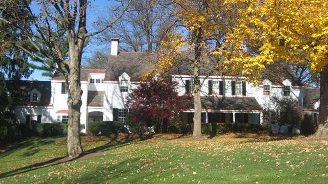
Photo: Nyttend, public domain · Wikimedia Commons
Local history sources: en.wikipedia.org · en.wikipedia.org · commons.wikimedia.org
Historic places
2 places in Amberley on the National Register of Historic Places. Press a pin or a name for its whole record.
-
Baxter, James, HouseBuilding · Amberley Village · listed 1994
- Address
- 2930 Fair Acres Dr.
- Where
- Amberley Village, Hamilton County · ZIP 45213
- What it is
- Building
- Listed on the National Register
- 1994
- NRIS reference number
- 94000774
- Coordinates
- 39.19255, -84.43234
National Register file (NPS) ↗ Search Wikipedia ↗ Street map and directions ↗ On the Cracked Buckeye map
-
Tonkens, Gerald B. and Beverley, HouseBuilding · Cincinnati · listed 1991
- Address
- 6980 Knoll Rd.
- Where
- Cincinnati, Hamilton County · ZIP 45237
- What it is
- Building
- Listed on the National Register
- 1991
- NRIS reference number
- 91001414
- Coordinates
- 39.19540, -84.41499
National Register file (NPS) ↗ Search Wikipedia ↗ Street map and directions ↗ On the Cracked Buckeye map
Source: National Park Service, National Register of Historic Places point file. The listing year is shown where NPS's certification date agrees with the listing's reference number. Listing recognizes significance; it does not restrict a private owner.
Water
Ohio River intake at the plant's riverfront on Kellogg Ave in the California neighborhood, east Cincinnati The water here
- Cincinnati Public Water System96% of residentsOhio River (Miller Plant, ~88%) plus Great Miami Buried Valley Aquifer wells (~12%)
- Reading City4% of residentsOhio River (Miller Plant, ~88%) plus Great Miami Buried Valley Aquifer wells (~12%)
Hospitals, fire stations and more
Inside Amberley's boundary: 1 fire or EMS station, 1 museum, 1 police station and 2 Toxics Release Inventory facilities. Press a pin or a name for its whole record and its source.
Fire and EMS stations (1)
-
Amberley Village Fire DepartmentCincinnati
- Address
- 7149 Ridge Road, Cincinnati, OH 45237
- Coordinates
- 39.19869, -84.43186
USGS National Map structures (source) ↗ Street map and directions ↗
Source: USGS National Map structures (most Ohio records last updated 2019 to 2022), checked against the Columbus and Cleveland station lists. The department that answers a call is set by jurisdiction and mutual aid, not by distance.
Museums, historical societies, gardens and zoos (1)
-
Plum Street TempleHistorical society · Cincinnati
- What it is
- Historical society
- City
- Cincinnati
- Coordinates
- 39.21365, -84.42676
Search Wikipedia ↗ IMLS Museum Data Files (source) ↗ Street map and directions ↗
The museum list is IMLS's 2018 file; a museum may have closed or moved since.
Source: IMLS Museum Data Files, 2018.
Police stations (1)
-
Amberley Police DepartmentCincinnati
- Address
- 7149 Ridge Road, Cincinnati, OH 45237
- Coordinates
- 39.19864, -84.43194
USGS National Map structures (source) ↗ Street map and directions ↗
Source: USGS National Map structures, police stations, corrected and completed by hand (September 2026). The department that answers a call is set by jurisdiction, not by distance.
Facilities reporting toxic releases (2)
-
Chester Packaging, LlcToxics Release Inventory · Cincinnati
- Address
- 1900 Section Rd., Suite A, Cincinnati, OH 45237
- County
- Hamilton County
- Status
- Reports to the Toxics Release Inventory (active)
- EPA program ID
- 45237CHSTR1900S
- EPA registry ID
- 110000393663
EPA facility record ↗ EPA Facility Registry Service (source) ↗ Street map and directions ↗
-
Pepsi-Cola General Bottlers of Cincinnati IncToxics Release Inventory · Cincinnati
- Address
- 2121 Sunnybrook Dr., Cincinnati, OH 45237
- County
- Hamilton County
- Status
- Reports to the Toxics Release Inventory (active)
- EPA program ID
- 45237PPSCL2121S
- EPA registry ID
- 110000393690
EPA facility record ↗ EPA Facility Registry Service (source) ↗ Street map and directions ↗
Source: EPA Facility Registry Service, Toxics Release Inventory reporters. Reporting a release is required of large users of listed chemicals; it is not by itself a violation.
Its ZIP codes
Each ZIP code that touches Amberley, with the share of its residents who live here and the same headline figures as the ZIP page.
Local government
Who holds office in Amberley, how its elections and ballot issues came out, and the state auditor's record.
Money issues on the ballot since 2022: 1 of 1 passed.
Ballot issues
| Date | Issue | For | Against | Result |
|---|---|---|---|---|
| 2022-05-03 | Issue 6: PROPOSED TAX LEVY (RENEWAL) VILLAGE OF AMBERLEY | 803 | 160 | Passed (83.39% for) |
Elections for office
| Date | Office | Candidates and votes |
|---|---|---|
| 2025-11-04 | Member of Council at Large | Jay L. Shatz 833, 42.44%; Keely Paul 596, 30.36%; Shelly Gerson 534, 27.2% |
| 2025-11-04 | Member of Council (District E) | Richard Bardach 692, 100.0% |
| 2025-11-04 | Member of Council (District D) | Bob Rosen 757, 100.0% |
| 2025-11-04 | Member of Council (District C) | Adam Frankel 747, 100.0% |
| 2025-11-04 | Member of Council (District B) | Dara L. Wood 716, 100.0% |
| 2025-11-04 | Member of Council (District A) | Benjamin Hunt 723, 100.0% |
| 2023-11-07 | Member of Council at Large | Jay L. Shatz 1,170, 54.67%; Keely Paul 970, 45.33% |
| 2023-11-07 | Member of Council (District E) | Richard Bardach 1,203, 100.0% |
| 2023-11-07 | Member of Council (District D) | Bob Rosen 1,267, 100.0% |
| 2023-11-07 | Member of Council (District C) | Adam Frankel 1,244, 100.0% |
| 2023-11-07 | Member of Council (District B) | Dara L. Wood 1,208, 100.0% |
| 2023-11-07 | Member of Council (District A) | Ben Hunt 1,229, 100.0% |
| 2021-11-02 | Member of Council at Large | Jay Shatz 566, 53.85%; Keely Paul 485, 46.15% |
| 2021-11-02 | Member of Council (District E) | Richard Bardach 546, 100.0% |
| 2021-11-02 | Member of Council (District D) | Robert Rosen 586, 100.0% |
| 2021-11-02 | Member of Council (District C) | Thomas C. Muething 626, 100.0% |
| 2021-11-02 | Member of Council (District B) | Natalie Wolf 603, 100.0% |
| 2021-11-02 | Member of Council (District A) | Benjamin Hunt 547, 100.0% |
Winners in bold. Results from the county board of elections' official canvass unless marked.
Auditor of State record
- No fiscal caution, watch or emergency on the Auditor of State's lists.
- Financial Audit, 2022 to 2023, released 2024-12-31
The county
Hamilton County: 54 ZIP codes, 47 cities, villages and townships, 843,791 people.
Nearby places
Rain and snow
How much has actually fallen on Amberley, day by day, from 1893 to now. Daily totals, not averages.
- rain, last 30 days
- 1.06 in
- 2026-09-29 to 2026-10-28
- rain so far in 2026
- 43.0 in
- 3.2 in above normal for the date
- snow so far in 2026
- 9.9 in
- a normal year brings 14.8 in
- a normal year
- 47.0 in
- average of 30 years, 1991-2020
| Month | Rain (in) | Snow (in) | Days counted |
|---|---|---|---|
| October 2026 | 1.06 | — | 28 |
| September 2026 | 6.14 | — | 30 |
| August 2026 | 5.04 | — | 31 |
| July 2026 | 4.65 | — | 31 |
| June 2026 | 6.05 | — | 30 |
| May 2026 | 6.70 | — | 31 |
| April 2026 | 3.75 | — | 30 |
| March 2026 | 6.56 | 0.1 | 31 |
| February 2026 | 1.26 | 3.7 | 28 |
| January 2026 | 1.77 | 6.2 | 31 |
| December 2025 | 2.58 | 10.5 | 31 |
| November 2025 | 3.88 | 1.8 | 30 |
| Wettest year | 2011 — 75.1 in |
|---|---|
| Driest year | 1901 — 22.4 in |
| Snowiest year | 2010 — 49.6 in |
| Wettest day on record | 5 March 1897 — 5.10 in |
| Heaviest snowfall in a day | 8 December 1917 — 11.29 in |
| Deepest snow on the ground | 6 February 1998 — 15.98 in |
Mostly estimated. Only 4% of these days come from a gauge standing inside Amberley - the rest are worked out from the nearest gauges around it, so read them as close estimates rather than readings.
47,956 days of records, 1893-01-01 to 2026-10-28. Source: NOAA NCEI GHCN-Daily, 3,240 gauges in and around Ohio. A day is "gauged" when a gauge standing inside the boundary reported it, and the value is the mean of those gauges. Otherwise it is interpolated by inverse distance from every gauge reporting within 50 miles. Nothing is carried forward, back-filled or smoothed. Against NOAA nClimDiv county monthly precipitation over 136,848 complete county-months (checked 2026-10-31): correlation 0.9515, median absolute difference 0.217 in a month. Built 2026-10-31 from the Cracked Buckeye precipitation archive. Snow is the softer number — snowfall is measured by hand with a ruler, no agency publishes a gridded county snowfall series, and blowing snow defeats every observer.
Environmental permits and filings
What Ohio EPA has on file for Amberley: permits, inspections, violations, cleanups and the state loans behind sewer and water work. Every line links to the agency's own document.
- facilities and sites on file
- 5
- those placed on the map inside Amberley
| Program | Facilities and sites |
|---|---|
| Hazardous waste | 2 |
| Composting | 1 |
| Underground injection wells | 1 |
| Wastewater and stormwater discharge | 1 |
| Date | Facility or site | What |
|---|---|---|
| INTEGRITY LANDSCAPING - AMBERLEY | Wastewater and stormwater discharge permit | |
| AMBERLEY VILLAGE | Composting inspection | |
| AMBERLEY VILLAGE | Composting report | |
| AMBERLEY VILLAGE | Composting inspection | |
| AMBERLEY VILLAGE | Composting report | |
| AMBERLEY VILLAGE | Composting inspection | |
| AMBERLEY VILLAGE | Composting report | |
| AMBERLEY VILLAGE | Composting inspection | |
| AMBERLEY VILLAGE | Composting report | |
| AMBERLEY VILLAGE | Composting inspection | |
| PROCTOR AND GAMBLE DISTRIBUTING LLC | Hazardous waste compliance letter | |
| AMBERLEY VILLAGE | Composting report | |
| AMBERLEY VILLAGE | Composting inspection | |
| AMBERLEY VILLAGE | Composting registration | |
| AMBERLEY VILLAGE | Composting report | |
| AMBERLEY VILLAGE | Composting inspection | |
| AMBERLEY VILLAGE | Composting inspection | |
| AMBERLEY VILLAGE | Composting report | |
| PROCTOR & GAMBLE DISTRIBUTING LLC - AMBERLEY BUS CTR | Hazardous waste compliance letter | |
| AMBERLEY VILLAGE | Composting inspection | |
| AMBERLEY VILLAGE | Composting report | |
| GIBSON GREETINGS INC | Underground injection wells inspection | |
| GIBSON GREETINGS INC | Underground injection wells inspection | |
| GIBSON GREETINGS INC | Underground injection wells monitoring results | |
| GIBSON GREETINGS INC | Underground injection wells inspection |
Source: Ohio EPA eDocument portal (edocpub.epa.ohio.gov), indexed 2026-10-14. Facilities are placed on the map from Ohio EPA's own map layers, EPA's Facility Registry, coordinates written in the filings, or a geocoded street address. A permit filed under a private person's name (most are household septic systems) is counted but never named, placed or linked; licenses for individual workers and open-burning notices are left out entirely.
Quick answers
What county is Amberley, Ohio in?
Amberley is a village in Hamilton County, Ohio, with 3,840 residents.
When was Amberley, Ohio founded?
Amberley was settled 1797; incorporated 1940. Founders on record: James Baxter (1797 land purchase, 1807 house); incorporated as a village April 5, 1940. Source
How did Amberley, Ohio get its name?
The village was named after Amberley, a village in West Sussex, England. Source
What ZIP code is Amberley, Ohio?
Amberley is served by ZIP codes 45237, 45236 and 45213; 45237 holds the largest share of its residents.
Where does Amberley, Ohio get its water?
The main water source for Amberley (Cincinnati Public Water System): Ohio River intake at the plant's riverfront on Kellogg Ave in the California neighborhood, east Cincinnati.
Cite this page
Cite this page as:
Cracked Buckeye, "Amberley, Hamilton County", https://crackedbuckeye.com/place/amberley/, built 2026-10-31, accessed [date].
How to cite · Report a correction · Built 2026-10-31
