Local events in Montgomery
10 events in the next 90 days from 1 public calendar. All local events in Montgomery
Checked October 20; the events page is refreshed daily.
How Montgomery began
Montgomery is one of Hamilton County's oldest settlements, dating to 1795 and formally laid out in 1802 by Nathaniel Terwilliger; settlers arriving from Montgomery, New York in 1806-1807 renamed the growing crossroads for their old home. It grew as a stagecoach stop on the Cincinnati-Zanesville Road (later Montgomery Pike), and Abraham Yost's 1805 tavern there sold more than fifty barrels of whiskey in 1809 alone, a measure of the traffic passing through. The town incorporated as a village in 1910 but stayed tiny for another half-century -- just 378 residents in 1920 -- before booming into a Cincinnati bedroom community after the 1960s and reincorporating as a city in 1971; it held 10,853 residents in 2020. It carries five buildings and districts on the National Register of Historic Places, more than almost any other unit in this survey, a dense cluster of early Federal and Classical Revival-era structures around its historic crossroads core.
Settled 1795, platted 1802 (Nathaniel Terwilliger), incorporated village, 1910; city, 1971, by Nathaniel Terwilliger; renamed by settlers from Montgomery, New York, 1806-1807.
Where the name comes from
Montgomery was named by settlers who arrived from Montgomery, New York in 1806-1807, who gave the growing crossroads community the name of their former home.
Before the town
No Native village, mound, or documented encounter specific to Montgomery itself was found in the sources consulted.
Timeline
- — Montgomery is first settled, one of the oldest settlements in Hamilton County.
- — Nathaniel Terwilliger formally lays out the town.
- — Abraham Yost builds a two-story tavern and residence on the highway to Cincinnati; it sells more than fifty barrels of whiskey in 1809 alone.
- — Settlers from Montgomery, New York rename the community for their old hometown.
- — White Miller buys the former Yost Tavern; his descendants occupy it until 1968.
- — Montgomery incorporates as a village.
- — Population is just 378, still a small crossroads village.
- — The Universalist Church Historic District, a 10-acre cluster of three Federal and Classical Revival buildings designed by architect James Jones, is listed on the National Register of Historic Places on December 2.
- — Montgomery reincorporates as a city.
- — The Montgomery Kiwanis Club, which had owned the former Yost Tavern since 1968, donates it to the city government.
- — Yost Tavern is listed on the National Register of Historic Places on May 6.
- — Population reaches 10,251, reflecting Montgomery's transformation into a dense Cincinnati suburb.
- — During the COVID-19 pandemic, Montgomery draws international attention for holding a "reverse parade," with residents driving past stationary floats in a high school parking lot; census population reaches 10,853.
Stories
Fifty barrels of whiskey in a year
Abraham Yost built his tavern in 1805, the same year Montgomery incorporated, on the well-traveled highway carrying goods and people toward Cincinnati -- a plain, two-story, gable-front building with a rear lean-to, weatherboarded over a stone foundation. Business found him fast: within four years, in 1809 alone, Yost's tavern sold more than fifty barrels of whiskey to travelers passing through, a startling volume that says as much about the road's traffic as it does about frontier drinking habits. The tavern outlived Yost by more than a century and a half as an ordinary private residence -- the Miller family alone held it from 1870 to 1968 -- until Montgomery's Kiwanis Club bought it, cleared out the old furnishings to the local historical society, and eventually handed the building to city government in 1979. Listed on the National Register in 1993, it now serves as an office headquarters, a quiet ending for a building that once measured its business in barrels.
Photographs
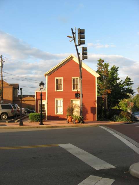
Photo: Nyttend, public domain · Wikimedia Commons
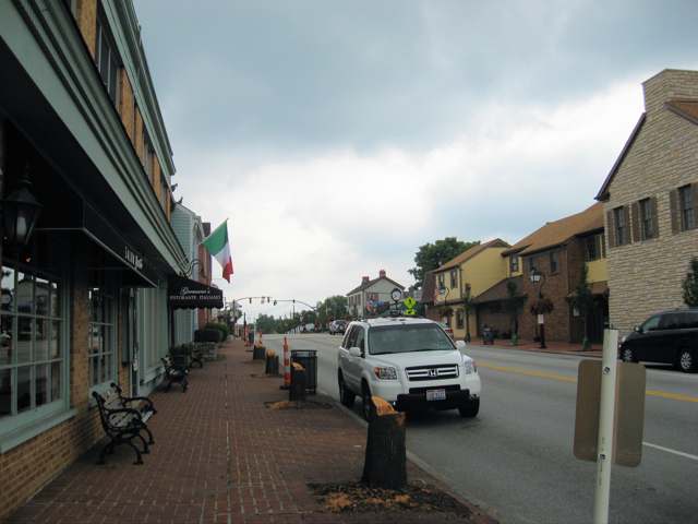
Photo: Ed!, CC BY-SA 3.0 · Wikimedia Commons
Local history sources: en.wikipedia.org · en.wikipedia.org · en.wikipedia.org · commons.wikimedia.org · commons.wikimedia.org
Historic places
5 places in Montgomery on the National Register of Historic Places. Press a pin or a name for its whole record.
-
Blair HouseBuilding · Montgomery · listed 1982
- Address
- 7844 Remington Rd (at West St.)
- Where
- Montgomery, Hamilton County · ZIP 45242
- What it is
- Building
- Listed on the National Register
- 1982
- NRIS reference number
- 82001466
- Coordinates
- 39.22830, -84.35945
National Register file (NPS) ↗ Search Wikipedia ↗ Street map and directions ↗ On the Cracked Buckeye map
-
Montgomery Saltbox HousesBuilding · Montgomery · listed 1987
- Address
- 7789 and 7795 Cooper Rd.
- Where
- Montgomery, Hamilton County · ZIP 45242
- What it is
- Building
- Listed on the National Register
- 1987
- NRIS reference number
- 87001254
- Coordinates
- 39.22632, -84.35536
National Register file (NPS) ↗ Search Wikipedia ↗ Street map and directions ↗ On the Cracked Buckeye map
-
Universalist Church Historic DistrictHistoric district · Montgomery · listed 1970
- Address
- Montgomery Rd. from 9433 N to Remington Ave.
- Where
- Montgomery, Hamilton County · ZIP 45242
- What it is
- Historic district
- Listed on the National Register
- 1970
- NRIS reference number
- 70000498
- Coordinates
- 39.22814, -84.35413
National Register file (NPS) ↗ Search Wikipedia ↗ Street map and directions ↗ On the Cracked Buckeye map
-
Wilder-Swaim HouseBuilding · Montgomery · listed 1981
- Address
- 7650 Cooper Rd.
- Where
- Montgomery, Hamilton County · ZIP 45242
- What it is
- Building
- Listed on the National Register
- 1981
- NRIS reference number
- 81000438
- Coordinates
- 39.22822, -84.35992
National Register file (NPS) ↗ Search Wikipedia ↗ Street map and directions ↗ On the Cracked Buckeye map
-
Yost TavernBuilding · Montgomery · listed 1993
- Address
- 7872 Cooper Rd.
- Where
- Montgomery, Hamilton County · ZIP 45242
- What it is
- Building
- Listed on the National Register
- 1993
- NRIS reference number
- 93000406
- Coordinates
- 39.22675, -84.35453
National Register file (NPS) ↗ Search Wikipedia ↗ Street map and directions ↗ On the Cracked Buckeye map
Source: National Park Service, National Register of Historic Places point file. The listing year is shown where NPS's certification date agrees with the listing's reference number. Listing recognizes significance; it does not restrict a private owner.
Water
Ohio River intake at the plant's riverfront on Kellogg Ave in the California neighborhood, east Cincinnati The water here
- Cincinnati Public Water System96% of residentsOhio River (Miller Plant, ~88%) plus Great Miami Buried Valley Aquifer wells (~12%)
- Indian Hill City3% of residentsLittle Miami River valley aquifer (wells near Milford)
- Loveland City1% of residentsLocal wells (Betty Ray well field, sand & gravel aquifer)
- Warren Co. Socialville0% of residentsOhio River (Miller Plant, ~88%) plus Great Miami Buried Valley Aquifer wells (~12%)
Hospitals, fire stations and more
Inside Montgomery's boundary: 2 hospitals, 3 nursing homes, 1 fire or EMS station, 3 public schools, 1 private school, 2 museums, 1 police station and 5 public charging sites. Press a pin or a name for its whole record and its source.
Hospitals (2)
-
Bethesda North Hospital Trauma level IIIGeneral hospital · Cincinnati
- What it is
- General hospital
- Address
- 10500 Montgomery Road, Cincinnati, OH 45242
- County
- Hamilton County
- Beds
- 528
- Trauma center
- Level IIi
- Helipad
- Yes
- Ownership
- Non-profit
- Medicare overall rating
- 3 of 5 stars
- Emergency department (Medicare)
- Yes
- Medicare reports it as
- Bethesda North
- Phone
- (513) 865-1221
- Medicare ID
- 360179
Medicare Care Compare ↗ Hospital's website ↗ Where HIFLD got this record ↗ HIFLD hospitals (source) ↗ Street map and directions ↗
-
Select Specialty Hospital - Cincinnati Dba SelectSpecialty hospital · Cincinnati
- What it is
- Specialty hospital
- Address
- 10500 Montgomery Rd First Floor, Cincinnati, OH 45242
- County
- Hamilton County
- Beds
- 41
- Helipad
- Yes
- Ownership
- Proprietary
- Phone
- (423) 341-1363
Where HIFLD got this record ↗ HIFLD hospitals (source) ↗ Street map and directions ↗
Source: HIFLD hospitals inventory via FEMA (closed hospitals it still lists left out, hospitals opened since added), with Medicare Care Compare ratings matched by name and address.
Nursing homes (3)
-
Meadowbrook Care Center1 of 5 stars · Cincinnati
- Address
- 8211 Weller Road, Cincinnati, OH 45242
- Certified beds
- 146
- Residents on an average day
- 101
- Medicare overall rating
- 1 of 5 stars
- Health inspections
- 1 of 5 stars
- Staffing
- 2 of 5 stars
- Quality measures
- 4 of 5 stars
- Penalties since 2023
- none
- Ownership
- For profit - Limited Liability company
- Chain
- CCH HEALTHCARE
- Takes
- Medicare and Medicaid
- Phone
- (513) 489-2444
- Medicare ID
- 365375
Medicare Care Compare ↗ CMS nursing home data (source) ↗ Street map and directions ↗
-
Montgomery Care Center3 of 5 stars · Cincinnati
- Address
- 7777 Cooper Road, Cincinnati, OH 45242
- Certified beds
- 99
- Residents on an average day
- 69
- Medicare overall rating
- 3 of 5 stars
- Health inspections
- 3 of 5 stars
- Staffing
- 2 of 5 stars
- Quality measures
- 4 of 5 stars
- Penalties since 2023
- none
- Ownership
- For profit - Limited Liability company
- Chain
- CARECORE HEALTH
- Takes
- Medicare and Medicaid
- Phone
- (513) 793-5092
- Medicare ID
- 365327
Medicare Care Compare ↗ CMS nursing home data (source) ↗ Street map and directions ↗
-
Twin Lakes5 of 5 stars · Cincinnati
- Address
- 9840 Montgomery Road, Cincinnati, OH 45242
- Certified beds
- 43
- Residents on an average day
- 39
- Medicare overall rating
- 5 of 5 stars
- Health inspections
- 5 of 5 stars
- Staffing
- 5 of 5 stars
- Quality measures
- 3 of 5 stars
- Penalties since 2023
- none
- Ownership
- Non profit - Corporation
- Continuing care retirement community
- Yes
- Takes
- Medicare and Medicaid
- Phone
- (513) 247-1301
- Medicare ID
- 366319
Medicare Care Compare ↗ CMS nursing home data (source) ↗ Street map and directions ↗
Source: CMS Care Compare nursing home provider and penalties files; Medicare star ratings run 1 to 5.
Fire and EMS stations (1)
-
Montgomery Fire DepartmentMontgomery
- Address
- 10150 Montgomery Road, Montgomery, OH 45242
- Coordinates
- 39.24302, -84.34669
USGS National Map structures (source) ↗ Street map and directions ↗
Source: USGS National Map structures (most Ohio records last updated 2019 to 2022), checked against the Columbus and Cleveland station lists. The department that answers a call is set by jurisdiction and mutual aid, not by distance.
Public schools (3)
-
Montgomery Elementary School5 of 5 stars · Cincinnati
- Address
- 9609 Montgomery Rd, Cincinnati, OH 45242
- School district
- Sycamore Community City School District
- Kind (NCES)
- Regular School
- Students, 2023-24
- 523
- Teachers (full-time equivalent)
- 28
- Report card, 2025-26
- 5 of 5 stars
- Performance index
- 100.3%
- Ohio building IRN
- 025387
- NCES school ID
- 390448601740
NCES school record ↗ Ohio School Report Card ↗ Street map and directions ↗
-
Sycamore High School5 of 5 stars · Cincinnati
- Address
- 7400 Cornell Rd, Cincinnati, OH 45242
- School district
- Sycamore Community City School District
- Kind (NCES)
- Regular School
- Students, 2023-24
- 1,677
- Teachers (full-time equivalent)
- 110.36
- Report card, 2025-26
- 5 of 5 stars
- Performance index
- 91.6%
- Four-year graduation rate
- 96.5%
- Ohio building IRN
- 036640
- NCES school ID
- 390448601741
NCES school record ↗ Ohio School Report Card ↗ Street map and directions ↗
-
Sycamore Junior High School5 of 5 stars · Cincinnati
- Address
- 5757 Cooper Rd, Cincinnati, OH 45242
- School district
- Sycamore Community City School District
- Kind (NCES)
- Regular School
- Students, 2023-24
- 859
- Teachers (full-time equivalent)
- 48
- Report card, 2025-26
- 5 of 5 stars
- Performance index
- 93.1%
- Ohio building IRN
- 066761
- NCES school ID
- 390448601742
NCES school record ↗ Ohio School Report Card ↗ Street map and directions ↗
Source: NCES EDGE public school locations 2024-25 and Common Core of Data 2023-24 (type, students, teachers); Ohio School Report Cards 2025-26 (Department of Education and Workforce), matched by name within the district.
Private schools (1)
-
Skyward AcademyPrivate, religious, independent · Cincinnati
- Address
- 9994 Zig Zag Rd, Cincinnati, OH 45242
- Kind
- religious, independent
- Students, 2023-24
- 61
- Teachers (full-time equivalent)
- 17
- Students per teacher
- 3.58824
- Phone
- (513) 222-4611
- NCES private school ID
- A1502985
Source: NCES Private School Survey 2023-24.
Museums, historical societies, gardens and zoos (2)
-
American Classical Music Hall Of Fame And MuseumMuseum · Cincinnati
- What it is
- Museum
- City
- Cincinnati
- Coordinates
- 39.24214, -84.36385
Search Wikipedia ↗ IMLS Museum Data Files (source) ↗ Street map and directions ↗
The museum list is IMLS's 2018 file; a museum may have closed or moved since.
-
Montgomery Historical Preservation AssociationHistorical society · Montgomery
- What it is
- Historical society
- City
- Montgomery
- Coordinates
- 39.22726, -84.35765
Search Wikipedia ↗ IMLS Museum Data Files (source) ↗ Street map and directions ↗
The museum list is IMLS's 2018 file; a museum may have closed or moved since.
Source: IMLS Museum Data Files, 2018.
Police stations (1)
-
Montgomery Police DepartmentCincinnati
- Address
- 10150 Montgomery Road, Cincinnati, OH 45242
- Coordinates
- 39.24275, -84.34689
USGS National Map structures (source) ↗ Street map and directions ↗
Source: USGS National Map structures, police stations, corrected and completed by hand (September 2026). The department that answers a call is set by jurisdiction, not by distance.
Public EV charging (5)
-
City of Montgomery - Shelly Ln Public Parking Lot2 Level 2 · Montgomery
- Address
- 9431 Shelly Lane, Montgomery, OH 45242
- Ports
- 2 Level 2
- Plugs
- J1772
- Network
- FLO
- Hours
- 24 hours daily
- Phone
- 888-356-8911
Station Locator (NREL) ↗ Alternative Fuels Data Center (source) ↗ Street map and directions ↗
-
Montgomery City Hall2 Level 2 · Montgomery
- Address
- 10101 Montgomery Rd, Montgomery, OH 45242
- Ports
- 2 Level 2
- Plugs
- J1772
- Network
- FLO
- Hours
- 24 hours daily
- Phone
- 888-356-8911
Station Locator (NREL) ↗ Alternative Fuels Data Center (source) ↗ Street map and directions ↗
-
Montgomery QTR Garage Block – Southern Building16 Level 2 · Montgomery
- Address
- 9260 Montgomery Rd., Montgomery, OH 45242
- Ports
- 16 Level 2
- Plugs
- J1772
- Network
- FLO
- Hours
- 24 hours daily
- Phone
- 888-356-8911
Station Locator (NREL) ↗ Alternative Fuels Data Center (source) ↗ Street map and directions ↗
-
TRIHEALTH BNH2 Level 2 · Montgomery
- Address
- 10500 Montgomery Rd, Montgomery, OH 45242
- Ports
- 2 Level 2
- Plugs
- J1772
- Network
- ChargePoint Network
- Hours
- 24 hours daily
- Phone
- 888-758-4389
Station Locator (NREL) ↗ Alternative Fuels Data Center (source) ↗ Street map and directions ↗
-
Vintage Club Garage4 Level 2 · Montgomery
- Address
- 22 Vintage Club Drive, Montgomery, OH 45242
- Ports
- 4 Level 2
- Plugs
- J1772
- Network
- FLO
- Hours
- 24 hours daily
- Phone
- 888-356-8911
Station Locator (NREL) ↗ Alternative Fuels Data Center (source) ↗ Street map and directions ↗
Source: NREL Alternative Fuels Data Center station list (May 2026), public and open stations, the posts at one address counted as one site.
Its ZIP codes
Each ZIP code that touches Montgomery, with the share of its residents who live here and the same headline figures as the ZIP page.
| ZIP | Share | Water | Radon | Home value | Schools | Flood |
|---|---|---|---|---|---|---|
| 45242 Blue Ash and Cincinnati | 36% | Ohio River intake at the plant's riverfront on Kellogg Ave in the California neighborhood, east Cincinnati | 3.4 pCi/L average radon | Median year built 1973 | Sycamore Community City · 5 stars overall | 0.0% of residents in the 1% floodplain |
| 45249 Symmes Township and Cincinnati | 17% | Ohio River intake at the plant's riverfront on Kellogg Ave in the California neighborhood, east Cincinnati | 3.4 pCi/L average radon | Median year built 1985 | Sycamore Community City · 5 stars overall | 1.9% of residents in the 1% floodplain |
Local government
Who holds office in Montgomery, how its elections and ballot issues came out, and the state auditor's record.
Elections for office
| Date | Office | Candidates and votes |
|---|---|---|
| 2025-11-04 | Member of Council at Large | Lee Ann Bissmeyer 1,745, 26.35%; Frank Forsthoefel 1,643, 24.81%; Sasha Naiman 1,634, 24.67%; Mike Cappel 1,601, 24.17% |
| 2023-11-07 | Member of Council at Large | Ken Suer 3,062, 29.93%; Craig Margolis 2,775, 27.13%; Catherine Mills-Reynolds 1,964, 19.2%; Tammy Moore 1,432, 14.0%; Martha A. Shields 996, 9.74% |
| 2021-11-02 | Member of Council at Large (Unexpired term ending 12-03-2023) | Ken Suer 2,345, 100.0% |
| 2021-11-02 | Member of Council at Large | Chris Dobrozsi 2,214, 23.09%; Lee Ann Bissmeyer 2,056, 21.44%; Sasha S. Naiman 1,892, 19.73%; Ronald G. Messer 1,849, 19.28%; Steve Uckotter 1,577, 16.45% |
Winners in bold. Results from the county board of elections' official canvass unless marked.
Auditor of State record
- No fiscal caution, watch or emergency on the Auditor of State's lists.
- Financial Health Indicators (the Auditor of State's 17 measures; critical / cautionary / positive): 2019 0 / 0 / 16; 2020 0 / 1 / 15; 2021 1 / 1 / 14; 2022 1 / 2 / 13; 2023 1 / 0 / 15; 2024 1 / 0 / 15.
- Financial Audit, 2025, released 2026-09-10
- Financial Audit, 2024, released 2025-09-25
- Financial Audit, 2023, released 2024-08-01
The county
Hamilton County: 54 ZIP codes, 47 cities, villages and townships, 843,791 people.
Nearby places
Rain and snow
How much has actually fallen on Montgomery, day by day, from 1893 to now. Daily totals, not averages.
- rain, last 30 days
- 1.19 in
- 2026-10-01 to 2026-10-30
- rain so far in 2026
- 45.8 in
- 5.2 in above normal for the date
- snow so far in 2026
- 13.8 in
- a normal year brings 17.0 in
- a normal year
- 47.7 in
- average of 30 years, 1991-2020
| Month | Rain (in) | Snow (in) | Days counted |
|---|---|---|---|
| October 2026 | 1.19 | — | 30 |
| September 2026 | 7.08 | — | 30 |
| August 2026 | 5.89 | — | 31 |
| July 2026 | 5.13 | — | 31 |
| June 2026 | 5.98 | — | 30 |
| May 2026 | 6.86 | — | 31 |
| April 2026 | 3.97 | — | 30 |
| March 2026 | 6.80 | 0.0 | 31 |
| February 2026 | 1.23 | 4.5 | 28 |
| January 2026 | 1.65 | 9.3 | 31 |
| December 2025 | 2.66 | 10.8 | 31 |
| November 2025 | 3.94 | 1.9 | 30 |
| Wettest year | 2011 — 73.2 in |
|---|---|
| Driest year | 1934 — 21.6 in |
| Snowiest year | 2010 — 46.2 in |
| Wettest day on record | 5 March 1897 — 4.92 in |
| Heaviest snowfall in a day | 23 December 2004 — 12.52 in |
| Deepest snow on the ground | 17 February 2010 — 14.83 in |
Estimated, not measured. No rain gauge has ever stood inside Montgomery, so every figure here is worked out from the gauges around it - the nearest ones weighted most. Treat them as close estimates rather than readings.
47,807 days of records, 1893-01-01 to 2026-10-30. Source: NOAA NCEI GHCN-Daily, 3,240 gauges in and around Ohio. A day is "gauged" when a gauge standing inside the boundary reported it, and the value is the mean of those gauges. Otherwise it is interpolated by inverse distance from every gauge reporting within 50 miles. Nothing is carried forward, back-filled or smoothed. Against NOAA nClimDiv county monthly precipitation over 136,848 complete county-months (checked 2026-11-01): correlation 0.9515, median absolute difference 0.217 in a month. Built 2026-11-01 from the Cracked Buckeye precipitation archive. Snow is the softer number — snowfall is measured by hand with a ruler, no agency publishes a gridded county snowfall series, and blowing snow defeats every observer.
Environmental permits and filings
What Ohio EPA has on file for Montgomery: permits, inspections, violations, cleanups and the state loans behind sewer and water work. Every line links to the agency's own document.
- facilities and sites on file
- 7
- those placed on the map inside Montgomery
| Program | Facilities and sites |
|---|---|
| Air pollution | 3 |
| Wastewater and stormwater discharge | 3 |
| Hazardous waste | 1 |
| Date | Facility or site | What |
|---|---|---|
| HAM SR 126 1950 (PID 114652) | Wastewater and stormwater discharge permit | |
| DON'S AUTO REPAIR | Air pollution report | |
| CAMARGO CADILLAC CO INC | Air pollution report | |
| CAPSTONE AT THE VINTAGE CLUB | Wastewater and stormwater discharge permit | |
| SYCAMORE HIGH SCHOOL BASEBALL & SOFTBALL SYNTHETIC TURF FIELDS | Wastewater and stormwater discharge permit | |
| SELECT SPECIALTY HOSPITAL - CINCINNATI NORTH | Air pollution permit | |
| BETHESDA HOSPITAL NORTH | Hazardous waste inspection | |
| BETHESDA HOSPITAL NORTH | Hazardous waste inspection | |
| BETHESDA HOSPITAL NORTH | Hazardous waste compliance letter | |
| BETHESDA HOSPITAL NORTH | Hazardous waste report | |
| SELECT SPECIALTY HOSPITAL - CINCINNATI NORTH | Air pollution permit | |
| SELECT SPECIALTY HOSPITAL - CINCINNATI NORTH | Air pollution permit | |
| BETHESDA HOSPITAL NORTH | Hazardous waste inspection | |
| BETHESDA HOSPITAL NORTH | Hazardous waste notice of violation |
Source: Ohio EPA eDocument portal (edocpub.epa.ohio.gov), indexed 2026-10-14. Facilities are placed on the map from Ohio EPA's own map layers, EPA's Facility Registry, coordinates written in the filings, or a geocoded street address. A permit filed under a private person's name (most are household septic systems) is counted but never named, placed or linked; licenses for individual workers and open-burning notices are left out entirely.
Quick answers
What county is Montgomery, Ohio in?
Montgomery is a city in Hamilton County, Ohio, with 10,790 residents.
When was Montgomery, Ohio founded?
Montgomery was settled 1795; laid out 1802 (Nathaniel Terwilliger); incorporated village, 1910; city, 1971. Founders on record: Nathaniel Terwilliger; renamed by settlers from Montgomery, New York, 1806-1807. Source
How did Montgomery, Ohio get its name?
Montgomery was named by settlers who arrived from Montgomery, New York in 1806-1807, who gave the growing crossroads community the name of their former home. Source
What ZIP code is Montgomery, Ohio?
Montgomery is served by ZIP codes 45242 and 45249; 45242 holds the largest share of its residents.
Where does Montgomery, Ohio get its water?
The main water source for Montgomery (Cincinnati Public Water System): Ohio River intake at the plant's riverfront on Kellogg Ave in the California neighborhood, east Cincinnati.
Cite this page
Cite this page as:
Cracked Buckeye, "Montgomery, Hamilton County", https://crackedbuckeye.com/place/montgomery/, built 2026-10-31, accessed [date].
How to cite · Report a correction · Built 2026-10-31