Local events in Evendale
Evendale itself has 4 events posted in the next 90 days; the others here are within 10 miles. All local events in Evendale
Checked October 20; the events page is refreshed daily.
Videos about Evendale
Short videos we made from the old maps and records. All videos
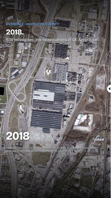
How Evendale began
Evendale grew up around a large aircraft-engine plant on Reading Road that broke ground on October 23, 1940 for the Wright Aeronautical division of Curtiss-Wright, and was dedicated on June 12, 1941 as American rearmament accelerated ahead of World War II. Ownership passed to Electric Auto-Lite before General Electric bought the plant outright in 1957, completing the purchase by the end of 1958; the site became "GE Evendale" after the surrounding village incorporated in 1952. GE moved the headquarters of its Aircraft Engine Group from Lynn, Massachusetts to Evendale in 1979, and the site, now GE Aerospace, remains the company's aircraft-engine headquarters today, the dominant force in the small village's economy and identity.
Incorporated 1952, by Village incorporated around the GE (formerly Wright Aeronautical) aircraft-engine plant.
Where the name comes from
The origin of the name "Evendale" is not documented.
Before the town
No Native American village, trail, mound or treaty line specific to the Evendale site itself is recorded; a village built up entirely around a twentieth-century industrial plant in the Mill Creek valley.
Timeline
- — An Evendale post office is listed among the Hamilton County post offices in the 1881 county history.
- — Ground is broken on October 23 for an aircraft-engine plant on Reading Road, built for the Wright Aeronautical division of Curtiss-Wright.
- — The plant is dedicated on June 12, ahead of full U.S. entry into World War II.
- — On February 28, the first two General Electric J47 jet engines built at the plant are delivered to the U.S. Air Force, marking its full operational opening under GE production.
- — The village of Evendale is established, after which the plant becomes known as "GE Evendale."
- — General Electric completes its purchase of the plant from Electric Auto-Lite, begun in 1957.
- — In September, GE announces it is moving the headquarters of its Aircraft Engine Group from Lynn, Massachusetts to Evendale.
- — The census counts 3,090 residents in Evendale.
- — The census counts 2,767 residents in Evendale.
- — The census counts 2,669 residents in Evendale.
Stories
A village built around a wartime engine plant
Evendale exists in its present form because of a single decision made on the eve of American rearmament: in October 1940, ground was broken on Reading Road for an aircraft-engine plant for Curtiss-Wright's Wright Aeronautical division, dedicated the next June just months before Pearl Harbor. Ownership shifted twice after the war, from Electric Auto-Lite to General Electric, which completed its purchase in 1958, and the surrounding community incorporated as the village of Evendale in 1952, giving the plant its lasting name, GE Evendale. The relationship deepened further in 1979, when GE moved the headquarters of its entire Aircraft Engine Group from Lynn, Massachusetts to the Evendale site, making a village of a few thousand residents the corporate and engineering center of one of the world's largest jet-engine makers, a status GE Aerospace's Evendale campus still holds.
Local history sources: en.wikipedia.org · en.wikipedia.org · en.wikipedia.org · en.wikipedia.org · archive.org
Water
Ohio River intake at the plant's riverfront on Kellogg Ave in the California neighborhood, east Cincinnati The water here
- Cincinnati Public Water System70% of residentsOhio River (Miller Plant, ~88%) plus Great Miami Buried Valley Aquifer wells (~12%)
- Butler Co. Water District 230% of residentsHamilton wells (Great Miami aquifer) + Cincinnati (Ohio River + wells)
Hospitals, fire stations and more
Inside Evendale's boundary: 1 fire or EMS station, 1 public school, 1 private school, 1 poor-rated bridge, 1 museum, 1 police station, 4 public charging sites, 1 Superfund site, 12 Toxics Release Inventory facilities and 10 spill cases. Press a pin or a name for its whole record and its source.
Fire and EMS stations (1)
-
Evendale Fire DepartmentCincinnati
- Address
- 10500 Reading Road, Cincinnati, OH 45241
- Coordinates
- 39.25624, -84.42043
USGS National Map structures (source) ↗ Street map and directions ↗
Source: USGS National Map structures (most Ohio records last updated 2019 to 2022), checked against the Columbus and Cleveland station lists. The department that answers a call is set by jurisdiction and mutual aid, not by distance.
Public schools (1)
-
Evendale Elementary School4 of 5 stars · Cincinnati
- Address
- 3940 Glendale Milford Rd, Cincinnati, OH 45241
- School district
- Princeton City School District
- Kind (NCES)
- Regular School
- Students, 2023-24
- 202
- Teachers (full-time equivalent)
- 20.5
- Report card, 2025-26
- 4 of 5 stars
- Performance index
- 90.9%
- Ohio building IRN
- 010843
- NCES school ID
- 390446701549
NCES school record ↗ Ohio School Report Card ↗ Street map and directions ↗
Source: NCES EDGE public school locations 2024-25 and Common Core of Data 2023-24 (type, students, teachers); Ohio School Report Cards 2025-26 (Department of Education and Workforce), matched by name within the district.
Private schools (1)
-
St Rita School for The DeafPrivate, Catholic · Cincinnati
- Address
- 1720 Glendale Milford Rd, Cincinnati, OH 45215
- Kind
- Catholic
- Students, 2023-24
- 50
- Teachers (full-time equivalent)
- 17.6
- Students per teacher
- 2.84091
- Phone
- (513) 771-7600
- NCES private school ID
- 01607873
Source: NCES Private School Survey 2023-24.
Bridges rated poor (1)
-
Glendale Milford over Norfolk Southern Rr-SortPoor · built 1960
- Condition
- Poor: a deck, superstructure, substructure or culvert rated 4 or below on the 0 to 9 scale
- What it is
- Bridge
- Built
- 1960
- Length
- 46 ft
- Owner
- City
- Vehicles a day
- 24,750
- Coordinates
- 39.25419, -84.43566
National Bridge Inventory (source) ↗ Street map and directions ↗
Source: FHWA National Bridge Inventory 2025. "Poor" means one major part rated 4 or below on the 0 to 9 scale; it calls for repair, not closing, unless the state posts or closes the bridge.
Museums, historical societies, gardens and zoos (1)
-
Gorman Heritage FarmArboretum or botanical garden · Cincinnati
- What it is
- Arboretum or botanical garden
- City
- Cincinnati
- Coordinates
- 39.24810, -84.42550
Search Wikipedia ↗ IMLS Museum Data Files (source) ↗ Street map and directions ↗
The museum list is IMLS's 2018 file; a museum may have closed or moved since.
Source: IMLS Museum Data Files, 2018.
Police stations (1)
-
Evendale Police DepartmentCincinnati
- Address
- 10500 Reading Road, Cincinnati, OH 45241
- Coordinates
- 39.25675, -84.41932
USGS National Map structures (source) ↗ Street map and directions ↗
Source: USGS National Map structures, police stations, corrected and completed by hand (September 2026). The department that answers a call is set by jurisdiction, not by distance.
Public EV charging (4)
-
Brendamour Evendale Business Center2 Level 2 · Cincinnati
- Address
- 2630 Glendale Milford Rd, Cincinnati, OH 45241
- Ports
- 2 Level 2
- Plugs
- J1772
- Network
- AMPUP
- Hours
- Contact station for hours of availability.
- Phone
- 833-692-6787
Station Locator (NREL) ↗ Alternative Fuels Data Center (source) ↗ Street map and directions ↗
-
Donnellon McCarthy Enterprises Inc2 Level 2 · Cincinnati
- Address
- 10855 Medallion Drive, Cincinnati, OH 45241
- Ports
- 2 Level 2
- Plugs
- J1772
- Network
- Blink Network
- Hours
- 24 hours daily
- Phone
- 888-998-2546
Station Locator (NREL) ↗ Alternative Fuels Data Center (source) ↗ Street map and directions ↗
-
TRIHEALTH EVENDALE2 Level 2 · Cincinnati
- Address
- 3155 Glendale Milford Rd, Cincinnati, OH 45241
- Ports
- 2 Level 2
- Plugs
- J1772
- Network
- ChargePoint Network
- Hours
- 24 hours daily
- Phone
- 888-758-4389
Station Locator (NREL) ↗ Alternative Fuels Data Center (source) ↗ Street map and directions ↗
-
Village of Evendale2 Level 2 · Cincinnati
- Address
- 10500 Reading Rd, Cincinnati, OH 45241
- Ports
- 2 Level 2
- Plugs
- J1772
- Network
- AMPUP
- Hours
- Contact station for hours of availability
- Phone
- 513-956-2665
Station Locator (NREL) ↗ Alternative Fuels Data Center (source) ↗ Street map and directions ↗
Source: NREL Alternative Fuels Data Center station list (May 2026), public and open stations, the posts at one address counted as one site.
Superfund sites (1)
-
Us Air Force Afp Plt 36Superfund program · Evendale
- Address
- I-75 at Neumann Way, N-123, Evendale, OH 45241
- County
- Hamilton County
- Status
- Superfund program site, not on the National Priorities List
- Federal facility
- Yes
- EPA program ID
- OH7570024623
- EPA registry ID
- 110009304270
EPA facility record ↗ EPA Facility Registry Service (source) ↗ Street map and directions ↗
Source: EPA Facility Registry Service, Superfund (SEMS) and National Priorities List sites. Many program sites were assessed and needed no cleanup.
Facilities reporting toxic releases (12)
-
Aluminum Extruded Shapes IncToxics Release Inventory · Cincinnati
- Address
- 10549 Reading Rd., Cincinnati, OH 45241
- County
- Hamilton County
- Status
- Reports to the Toxics Release Inventory (active)
- EPA program ID
- 45241LMNMX10549
- EPA registry ID
- 110002113338
EPA facility record ↗ EPA Facility Registry Service (source) ↗ Street map and directions ↗
-
Cincinnati Electronics CorpToxics Release Inventory · Cincinnati
- Address
- 2630 Glendale - Milford Rd, Cincinnati, OH 45241
- County
- Hamilton County
- Status
- Reports to the Toxics Release Inventory (active)
- EPA program ID
- 45241CNCNN2630G
- EPA registry ID
- 110001626036
EPA facility record ↗ EPA Facility Registry Service (source) ↗ Street map and directions ↗
-
Formica Corporation - Evendale (1431150801)Toxics Release Inventory · Cincinnati
- Address
- 10155 Reading Rd., Cincinnati, OH 45241
- County
- Hamilton County
- Status
- Reports to the Toxics Release Inventory (active)
- EPA program ID
- 45241FRMCC10155
- EPA registry ID
- 110000393725
EPA facility record ↗ EPA Facility Registry Service (source) ↗ Street map and directions ↗
-
Ge Aerospace Evendale PlantToxics Release Inventory · Cincinnati
- Address
- One Neumann Way, Cincinnati, OH 45215
- County
- Hamilton County
- Status
- Reports to the Toxics Release Inventory
- EPA program ID
- 45215GNRLL1NEUM
- EPA registry ID
- 110000393191
EPA facility record ↗ EPA Facility Registry Service (source) ↗ Street map and directions ↗
-
Graphic Packaging InternationalToxics Release Inventory · Cincinnati
- Address
- 10600 Evendale Drive, Cincinnati, OH 45241
- County
- Hamilton County
- Status
- Reports to the Toxics Release Inventory (active)
- EPA program ID
- 45241MNVLL10600
- EPA registry ID
- 110000814860
EPA facility record ↗ EPA Facility Registry Service (source) ↗ Street map and directions ↗
-
Kdm Signs, Inc. (1431153991)Toxics Release Inventory · Cincinnati
- Address
- 10450 North Medallion Drive, Cincinnati, OH 45241
- County
- Hamilton County
- Status
- Reports to the Toxics Release Inventory (active)
- EPA program ID
- 45241KDMSG145NM
- EPA registry ID
- 110000393066
EPA facility record ↗ EPA Facility Registry Service (source) ↗ Street map and directions ↗
-
Masonite CorpToxics Release Inventory · Cincinnati
- Address
- 10360 Evendale Dr, Cincinnati, OH 45241
- County
- Hamilton County
- Status
- Reports to the Toxics Release Inventory (closed)
- EPA program ID
- 45241MSNTC10360
- EPA registry ID
- 110001626385
EPA facility record ↗ EPA Facility Registry Service (source) ↗ Street map and directions ↗
-
National Starch & Chemical CoToxics Release Inventory · Cincinnati
- Address
- 2960 Exon Avenue, Cincinnati, OH 45241
- County
- Hamilton County
- Status
- Reports to the Toxics Release Inventory (active)
- EPA program ID
- 45241NTNLS2960E
- EPA registry ID
- 110000393734
EPA facility record ↗ EPA Facility Registry Service (source) ↗ Street map and directions ↗
-
Neyra Inds IncToxics Release Inventory · Cincinnati
- Address
- 10700 Evendale Drive, Cincinnati, OH 45241
- County
- Hamilton County
- Status
- Reports to the Toxics Release Inventory (active)
- EPA program ID
- 45241NYRND10700
- EPA registry ID
- 110004577912
EPA facility record ↗ EPA Facility Registry Service (source) ↗ Street map and directions ↗
-
Nisbet-Brower Marble, LlcToxics Release Inventory · Cincinnati
- Address
- 10801 Reading Rd, Cincinnati, OH 45241
- County
- Hamilton County
- Status
- Reports to the Toxics Release Inventory (active)
- EPA program ID
- 45241NSBTB181RE
- EPA registry ID
- 110014360716
EPA facility record ↗ EPA Facility Registry Service (source) ↗ Street map and directions ↗
-
Sealtron IncToxics Release Inventory · Cincinnati
- Address
- 9705 Reading Rd., Cincinnati, OH 45215
- County
- Hamilton County
- Status
- Reports to the Toxics Release Inventory (active)
- EPA program ID
- 45215SLTRN9705R
- EPA registry ID
- 110002113105
EPA facility record ↗ EPA Facility Registry Service (source) ↗ Street map and directions ↗
-
Univar Solutions Usa Llc - Evendale (1431152467)Toxics Release Inventory · Evendale
- Address
- 2788 Glendale-Milford Rd, Evendale, OH 45241
- County
- Hamilton County
- Status
- Reports to the Toxics Release Inventory (active)
- EPA program ID
- 45241SHLND2788G
- EPA registry ID
- 110000393743
EPA facility record ↗ EPA Facility Registry Service (source) ↗ Street map and directions ↗
Source: EPA Facility Registry Service, Toxics Release Inventory reporters. Reporting a release is required of large users of listed chemicals; it is not by itself a violation.
Spills reported since 2021 (10)
-
Ammonia (Nh3)2025-04-17 · Evendale
- Reported
- 2025-04-17
- What spilled
- Ammonia (Nh3)
- Where
- Evendale, Hamilton County
- Ohio EPA district office
- SWDO
- Ohio EPA case number
- 2504EPA0000582
Ohio EPA spill reports (source) ↗ Street map and directions ↗
-
Contaminated Water2024-06-19 · Evendale
- Reported
- 2024-06-19
- What spilled
- Contaminated Water
- Largest amount reported
- 1,000 gallons
- Where
- Evendale, Hamilton County
- Ohio EPA district office
- SWDO
- Ohio EPA case number
- 2406EPA0001036
Ohio EPA spill reports (source) ↗ Street map and directions ↗
-
Oil Petroleum Not Otherwise Specified (Nos) Reached water2024-04-11 · Evendale
- Reported
- 2024-04-11
- What spilled
- Oil Petroleum Not Otherwise Specified (Nos)
- Reached a waterway
- 99 - Unnamed
- Where
- Evendale, Hamilton County
- Ohio EPA district office
- SWDO
- Ohio EPA case number
- 2404EPA0000595
Ohio EPA spill reports (source) ↗ Street map and directions ↗
-
Oil Vegetable / Bio Reached water2024-03-21 · Evendale
- Reported
- 2024-03-21
- What spilled
- Oil Vegetable / Bio
- Reached a waterway
- 31 - Mill Creek
- Where
- Evendale, Hamilton County
- Ohio EPA district office
- SWDO
- Ohio EPA case number
- 2403EPA0000448
Ohio EPA spill reports (source) ↗ Street map and directions ↗
-
Oil Hydraulic Fluid(S)2023-07-19 · Evendale
- Reported
- 2023-07-19
- What spilled
- Oil Hydraulic Fluid(S)
- Largest amount reported
- 25 gallons
- Where
- Evendale, Hamilton County
- Ohio EPA district office
- SWDO
- Ohio EPA case number
- 2307EPA0001211
Ohio EPA spill reports (source) ↗ Street map and directions ↗
-
Potassium Hydroxide / Potash Lye / Caustic Potash (Koh)2023-07-06 · Evendale
- Reported
- 2023-07-06
- What spilled
- Potassium Hydroxide / Potash Lye / Caustic Potash (Koh)
- Where
- Evendale, Hamilton County
- Ohio EPA district office
- SWDO
- Ohio EPA case number
- 2307EPA0001114
Ohio EPA spill reports (source) ↗ Street map and directions ↗
-
Ink / Printing Ink2022-08-01 · Evendale
- Reported
- 2022-08-01
- What spilled
- Ink / Printing Ink
- Largest amount reported
- 30 gallons
- Where
- Evendale, Hamilton County
- Ohio EPA district office
- SWDO
- Ohio EPA case number
- 2208EPA0001162
Ohio EPA spill reports (source) ↗ Street map and directions ↗
-
Oil Crude Reached water2022-06-07 · Evendale
- Reported
- 2022-06-07
- What spilled
- Oil Crude
- Largest amount reported
- 100 gallons
- Reached a waterway
- 99 - Unnamed
- Where
- Evendale, Hamilton County
- Ohio EPA district office
- SWDO
- Ohio EPA case number
- 2206EPA0000849
Ohio EPA spill reports (source) ↗ Street map and directions ↗
-
Oil Hydraulic Fluid(S)2026-03-18 · Evendale
- Reported
- 2026-03-18
- What spilled
- Oil Hydraulic Fluid(S)
- Largest amount reported
- 25 gallons
- Where
- Evendale, Hamilton County
- Ohio EPA district office
- SWDO
- Ohio EPA case number
- 2603EPA0000426
Ohio EPA spill reports (source) ↗ Street map and directions ↗
-
Ammonia (Nh3)2026-03-01 · Evendale
- Reported
- 2026-03-01
- What spilled
- Ammonia (Nh3)
- Where
- Evendale, Hamilton County
- Ohio EPA district office
- SWDO
- Ohio EPA case number
- 2603EPA0000268
Ohio EPA spill reports (source) ↗ Street map and directions ↗
Source: Ohio EPA emergency response spill reports, 2021 to September 2026, one point per case where Ohio EPA placed it. A report is what the caller or responder recorded; amounts are often blank or estimated.
Its ZIP codes
Each ZIP code that touches Evendale, with the share of its residents who live here and the same headline figures as the ZIP page.
| ZIP | Share | Water | Radon | Home value | Schools | Flood |
|---|---|---|---|---|---|---|
| 45241 Sharonville and Cincinnati | 11% | Ohio River intake at the plant's riverfront on Kellogg Ave in the California neighborhood, east Cincinnati | 3.5 pCi/L average radon | Median year built 1981 | Princeton City · 4 stars overall | 2.8% of residents in the 1% floodplain |
Local government
Who holds office in Evendale, how its elections and ballot issues came out, and the state auditor's record.
Elections for office
| Date | Office | Candidates and votes |
|---|---|---|
| 2025-11-04 | Member of Council | Steven Berke 582, 37.07%; Mike Stroh 502, 31.97%; Wanda Walker-Smith 486, 30.96% |
| 2023-11-07 | Member of Council | Beth McDaniel 1,077, 31.45%; Christopher Patterson 964, 28.15%; Tom Sextro 928, 27.09%; Diane Cunningham Redden 456, 13.31% |
| 2023-11-07 | Mayor | Richard H. Finan 1,094, 75.97%; Stiney Vonderhaar 346, 24.03% |
| 2021-11-02 | Member of Council | Steven J. Berke 695, 30.09%; Carolyn Smiley-Robertson 602, 26.06%; Bill Puthoff 576, 24.94%; Tim Sansbury 437, 18.92% |
Winners in bold. Results from the county board of elections' official canvass unless marked.
Auditor of State record
- No fiscal caution, watch or emergency on the Auditor of State's lists.
- Financial Audit, 2025, released 2026-05-26
- Financial Audit, 2024, released 2025-04-01
- Financial Audit, 2023, released 2024-08-20
The county
Hamilton County: 54 ZIP codes, 47 cities, villages and townships, 843,791 people.
Nearby places
Rain and snow
How much has actually fallen on Evendale, day by day, from 1893 to now. Daily totals, not averages.
- rain, last 30 days
- 1.12 in
- 2026-09-29 to 2026-10-28
- rain so far in 2026
- 45.3 in
- 5.9 in above normal for the date
- snow so far in 2026
- 12.6 in
- a normal year brings 15.1 in
- a normal year
- 46.6 in
- average of 30 years, 1991-2020
| Month | Rain (in) | Snow (in) | Days counted |
|---|---|---|---|
| October 2026 | 1.12 | — | 28 |
| September 2026 | 6.42 | — | 30 |
| August 2026 | 5.91 | — | 31 |
| July 2026 | 4.90 | — | 31 |
| June 2026 | 6.32 | — | 30 |
| May 2026 | 7.07 | — | 31 |
| April 2026 | 3.79 | — | 30 |
| March 2026 | 6.84 | 0.1 | 31 |
| February 2026 | 1.25 | 3.7 | 28 |
| January 2026 | 1.65 | 8.8 | 31 |
| December 2025 | 2.55 | 11.2 | 31 |
| November 2025 | 3.90 | 2.0 | 30 |
| Wettest year | 2011 — 75.7 in |
|---|---|
| Driest year | 1934 — 21.6 in |
| Snowiest year | 2010 — 52.1 in |
| Wettest day on record | 5 March 1897 — 4.61 in |
| Heaviest snowfall in a day | 8 December 1917 — 11.53 in |
| Deepest snow on the ground | 20 December 1919 — 17.02 in |
Estimated, not measured. No rain gauge has ever stood inside Evendale, so every figure here is worked out from the gauges around it - the nearest ones weighted most. Treat them as close estimates rather than readings.
48,096 days of records, 1893-01-01 to 2026-10-28. Source: NOAA NCEI GHCN-Daily, 3,240 gauges in and around Ohio. A day is "gauged" when a gauge standing inside the boundary reported it, and the value is the mean of those gauges. Otherwise it is interpolated by inverse distance from every gauge reporting within 50 miles. Nothing is carried forward, back-filled or smoothed. Against NOAA nClimDiv county monthly precipitation over 136,848 complete county-months (checked 2026-10-31): correlation 0.9515, median absolute difference 0.217 in a month. Built 2026-10-31 from the Cracked Buckeye precipitation archive. Snow is the softer number — snowfall is measured by hand with a ruler, no agency publishes a gridded county snowfall series, and blowing snow defeats every observer.
Environmental permits and filings
What Ohio EPA has on file for Evendale: permits, inspections, violations, cleanups and the state loans behind sewer and water work. Every line links to the agency's own document.
- facilities and sites on file
- 37
- those placed on the map inside Evendale
| Program | Facilities and sites |
|---|---|
| Hazardous waste | 13 |
| Air pollution | 10 |
| Site assessment | 6 |
| Wastewater and stormwater discharge | 4 |
| Contaminated-site cleanup | 2 |
| Municipal Solid Waste Transfer Facilities | 1 |
| Voluntary cleanup | 1 |
| Date | Facility or site | What |
|---|---|---|
| GENERAL ELECTRIC AEROSPACE - EVENDALE PLANT | Air pollution permit | |
| FORMICA CORP EVENDALE PLANT | Hazardous waste assessment | |
| LINEHAUL HEAVY DUTY LLC | Hazardous waste violation resolved | |
| FORMICA CORP EVENDALE PLANT | Air pollution permit | |
| KDM SIGNS INC | Air pollution permit | |
| FORMICA CORP EVENDALE PLANT | Wastewater and stormwater discharge violation resolved | |
| LINEHAUL HEAVY DUTY LLC | Hazardous waste notice of violation | |
| GENERAL ELECTRIC AEROSPACE - EVENDALE PLANT | Air pollution inspection | |
| FORMICA CORP EVENDALE PLANT | Wastewater and stormwater discharge permit | |
| FORMICA CORP EVENDALE PLANT | Air pollution permit | |
| KDM SIGNS INC | Air pollution permit | |
| FORMICA CORP EVENDALE PLANT | Wastewater and stormwater discharge notice of violation | |
| SO-LOW ENVIRONMENTAL EQUIPMENT CO | Air pollution report | |
| WORLDWIDE EQUIPMENT INC | Air pollution report | |
| FORMICA CORP EVENDALE PLANT | Hazardous waste report | |
| FORMICA CORP EVENDALE PLANT | Air pollution permit | |
| KDM SIGNS INC | Air pollution permit | |
| REPUBLIC SERVICES EVENDALE TRANSFER FACILITY | Municipal Solid Waste Transfer Facilities inspection | |
| FORMICA CORP EVENDALE PLANT | Wastewater and stormwater discharge report | |
| UNIVAR USA- CINCINNATI (EX) | Voluntary cleanup director's approval | |
| UNIVAR USA- CINCINNATI (EX) | Voluntary cleanup director's approval | |
| UNIVAR SOLUTIONS USA LLC - EVENDALE | Air pollution permit | |
| KDM SIGNS INC | Air pollution notice of violation | |
| REPUBLIC SERVICES EVENDALE TRANSFER FACILITY | Municipal Solid Waste Transfer Facilities report | |
| SHARONVILLE IMF EAST LOT | Wastewater and stormwater discharge permit |
Source: Ohio EPA eDocument portal (edocpub.epa.ohio.gov), indexed 2026-10-14. Facilities are placed on the map from Ohio EPA's own map layers, EPA's Facility Registry, coordinates written in the filings, or a geocoded street address. A permit filed under a private person's name (most are household septic systems) is counted but never named, placed or linked; licenses for individual workers and open-burning notices are left out entirely.
Quick answers
What county is Evendale, Ohio in?
Evendale is a village in Hamilton County, Ohio, with 2,669 residents.
When was Evendale, Ohio founded?
Evendale was incorporated 1952. Founders on record: Village incorporated around the GE (formerly Wright Aeronautical) aircraft-engine plant. Source
How did Evendale, Ohio get its name?
The origin of the name "Evendale" is not documented. Source
What ZIP code is Evendale, Ohio?
Most of Evendale is in ZIP code 45241.
Where does Evendale, Ohio get its water?
The main water source for Evendale (Cincinnati Public Water System): Ohio River intake at the plant's riverfront on Kellogg Ave in the California neighborhood, east Cincinnati.
Cite this page
Cite this page as:
Cracked Buckeye, "Evendale, Hamilton County", https://crackedbuckeye.com/place/evendale/, built 2026-10-31, accessed [date].
How to cite · Report a correction · Built 2026-10-31
