Local events in Indian Hill
20 events in the next 90 days from 1 public calendar. All local events in Indian Hill
Checked October 20; the events page is refreshed daily.
How Indian Hill began
Indian Hill began as a farming community in the early 1800s, on ground where Shawnee, Miami, and Delaware (Lenape) people had hunted and fished; the schoolhouse district built the still-standing brick Jefferson Schoolhouse in 1851, Indian Hill's oldest surviving building. Around 1904 the area became a weekend retreat for wealthy Cincinnatians who rode the Swing Line train out from downtown, and in 1924 four Cincinnati businessmen who had already built homes there formed the Camargo Realty Company, assembling 12,000 acres and reselling it in 25-acre estate lots. John J. Emery's 1,200-acre estate, Peterloon, was one of the grandest results, later subdivided into smaller lots. Indian Hill incorporated as a village and became a city once its population passed 5,000, formally naming itself "The City of The Village of Indian Hill"; by 2023 Forbes ranked it Ohio's third-wealthiest ZIP code, with a 2021 median household income of $194,643.
Settled early 1800s (farming community), incorporated village, before 1970; city ("The City of The Village of Indian Hill"), 1970s once population passed 5,000, by Camargo Realty Company (1924 estate development).
Where the name comes from
The name reflects the area's early Native American history and use as hunting and fishing ground by the Shawnee, Miami, and Delaware (Lenape); no source consulted identifies a specific hill, trail, or documented site behind the name.
Before the town
Indian Hill's own name commemorates its use by the Shawnee, Miami, and Lenape (Delaware) for hunting and fishing in the early historic period, though no source consulted names a specific village, trail, or site within the modern city bounds.
Nations recorded here: Shawnee, Miami, Lenape (Delaware).
Timeline
- — The Jefferson Schoolhouse, a one-room brick school on Drake Road, is built; it is one of three area schools (with Franklin and Washington) and the only one to survive.
- — An ell addition to the Jefferson Schoolhouse creates two classrooms, separating grades 1-4 from 5-8.
- — Wealthy Cincinnatians begin using the area as a weekend retreat, reached by the Swing Line train from downtown to Ramona Station.
- — Four Cincinnati businessmen who had built early homes in the area form the Camargo Realty Company, assembling 12,000 acres and subdividing it into 25-acre lots priced $75-$150 per acre; John J. Emery's 1,200-acre Peterloon estate is among the results.
- — A further addition doubles the Jefferson Schoolhouse's capacity.
- — The Jefferson Schoolhouse ends regular educational use and becomes a community center, later the Armstrong Community Building.
- — Population is 2,090.
- — Population reaches 5,651, crossing the threshold at which Ohio law reclassifies a village as a city; Indian Hill adopts the formal name "The City of The Village of Indian Hill."
- — The Jefferson Schoolhouse, by then owned by Armstrong Chapel United Methodist Church, is listed on the National Register of Historic Places on March 17.
- — Census population is 6,087.
- — Forbes ranks Indian Hill's ZIP code third-wealthiest in Ohio; the 2021 median household income was $194,643 and median home value $918,000.
Stories
From a one-room school to Ohio's third-richest ZIP code
In 1851, the families around what is now Indian Hill built the Jefferson Schoolhouse, a plain single-room brick building for children whose parents mostly farmed the surrounding land; by the 1940s it had been outgrown and downgraded to a community center. In between, the whole character of the place changed almost completely. Around 1904, wealthy Cincinnatians discovered the area as a weekend retreat, reachable by a dedicated rail line, the Swing Line, running out from downtown to a station whose site is now Indian Hill's own administration building. Twenty years later, in 1924, four of those businessmen who had already built weekend homes there formalized the transformation, forming the Camargo Realty Company and buying up 12,000 acres to resell as 25-acre estate lots -- among them the 1,200-acre spread John J. Emery built and named Peterloon. The math tells the rest: a community that counted just over 2,000 residents in 1950 crossed the threshold to become "The City of The Village of Indian Hill" by 1970, and by 2023 Forbes was ranking its ZIP code third-wealthiest in the entire state, a farming crossroads turned into one of Ohio's most exclusive addresses within a single long lifetime.
Photographs
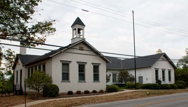
Photo: Greg Hume, CC BY-SA 3.0 · Wikimedia Commons
Local history sources: en.wikipedia.org · en.wikipedia.org · en.wikipedia.org · commons.wikimedia.org
Historic places
5 places in Indian Hill on the National Register of Historic Places. Press a pin or a name for its whole record.
-
Elliott HouseBuilding · Remington · listed 1976
- Address
- 9352 Given Rd.
- Where
- Remington, Hamilton County · ZIP 45243
- What it is
- Building
- Listed on the National Register
- 1976
- NRIS reference number
- 76001451
- Coordinates
- 39.22328, -84.32107
National Register file (NPS) ↗ Search Wikipedia ↗ Street map and directions ↗ On the Cracked Buckeye map
-
Jefferson SchoolhouseBuilding · Indian Hill · listed 1976
- Address
- Indian Hill and Drake Rds.
- Where
- Indian Hill, Hamilton County · ZIP 45243
- What it is
- Building
- Listed on the National Register
- 1976
- NRIS reference number
- 76001450
- Coordinates
- 39.16108, -84.34681
National Register file (NPS) ↗ Search Wikipedia ↗ Street map and directions ↗ On the Cracked Buckeye map
-
Sunny Knolls--Pape, Gordon E., HouseBuilding · Inidan Hill · listed 2006
- Address
- 8725 Blome Rd.
- Where
- Inidan Hill, Hamilton County · ZIP 45243
- What it is
- Building
- Listed on the National Register
- 2006
- NRIS reference number
- 06000484
- Coordinates
- 39.21593, -84.34724
National Register file (NPS) ↗ Search Wikipedia ↗ Street map and directions ↗ On the Cracked Buckeye map
-
United Methodist ChurchBuilding · Mariemont · listed 1975
- Address
- 5125 Drake Rd., NE of Mariemont
- Where
- Mariemont, Hamilton County · ZIP 45243
- What it is
- Building
- Listed on the National Register
- 1975
- NRIS reference number
- 75001432
- Coordinates
- 39.16045, -84.34695
National Register file (NPS) ↗ Search Wikipedia ↗ Street map and directions ↗ On the Cracked Buckeye map
-
Washington Heights SchoolBuilding · Indian Hill · listed 1975
- Address
- 8100 Given Rd.
- Where
- Indian Hill, Hamilton County · ZIP 45243
- What it is
- Building
- Listed on the National Register
- 1975
- NRIS reference number
- 75001430
- Coordinates
- 39.20316, -84.32369
National Register file (NPS) ↗ Search Wikipedia ↗ Street map and directions ↗ On the Cracked Buckeye map
Source: National Park Service, National Register of Historic Places point file. The listing year is shown where NPS's certification date agrees with the listing's reference number. Listing recognizes significance; it does not restrict a private owner.
Water
Nine wells in the Little Miami aquifer along the Little Miami River between Milford and Camp Dennison, next to the plant at 7100 Glendale Milford Rd (SR 126). The water here
- Indian Hill City59% of residentsLittle Miami River valley aquifer (wells near Milford)
- Cincinnati Public Water System41% of residentsOhio River (Miller Plant, ~88%) plus Great Miami Buried Valley Aquifer wells (~12%)
Hospitals, fire stations and more
Inside Indian Hill's boundary: 1 fire or EMS station, 4 public schools, 1 museum, 1 police station, 1 Superfund site and 8 spill cases. Press a pin or a name for its whole record and its source.
Fire and EMS stations (1)
-
Madeira and Indian Hill Joint Fire District Station 64Indian Hill
- Address
- 6475 Drake Road, Indian Hill, OH 45243
- Coordinates
- 39.18050, -84.34594
USGS National Map structures (source) ↗ Street map and directions ↗
Source: USGS National Map structures (most Ohio records last updated 2019 to 2022), checked against the Columbus and Cleveland station lists. The department that answers a call is set by jurisdiction and mutual aid, not by distance.
Public schools (4)
-
Indian Hill Elementary School5 of 5 stars · Cincinnati
- Address
- 6100 Drake Rd, Cincinnati, OH 45243
- School district
- Indian Hill Ex Vill School District
- Kind (NCES)
- Regular School
- Students, 2023-24
- 523
- Teachers (full-time equivalent)
- 29.32
- Report card, 2025-26
- 5 of 5 stars
- Performance index
- 96.7%
- Ohio building IRN
- 008763
- NCES school ID
- 390454302212
NCES school record ↗ Ohio School Report Card ↗ Street map and directions ↗
-
Indian Hill High School4.5 of 5 stars · Cincinnati
- Address
- 6865 Drake Rd, Cincinnati, OH 45243
- School district
- Indian Hill Ex Vill School District
- Kind (NCES)
- Regular School
- Students, 2023-24
- 659
- Teachers (full-time equivalent)
- 48.97
- Report card, 2025-26
- 4.5 of 5 stars
- Performance index
- 91.3%
- Four-year graduation rate
- 95.8%
- Ohio building IRN
- 017301
- NCES school ID
- 390454302213
NCES school record ↗ Ohio School Report Card ↗ Street map and directions ↗
-
Indian Hill Middle School5 of 5 stars · Cincinnati
- Address
- 6845 Drake Rd, Cincinnati, OH 45243
- School district
- Indian Hill Ex Vill School District
- Kind (NCES)
- Regular School
- Students, 2023-24
- 548
- Teachers (full-time equivalent)
- 42.58
- Report card, 2025-26
- 5 of 5 stars
- Performance index
- 96.7%
- Ohio building IRN
- 043158
- NCES school ID
- 390454302214
NCES school record ↗ Ohio School Report Card ↗ Street map and directions ↗
-
Indian Hill Primary Elementary School5 of 5 stars · Cincinnati
- Address
- 6207 Drake Rd, Cincinnati, OH 45243
- School district
- Indian Hill Ex Vill School District
- Kind (NCES)
- Regular School
- Students, 2023-24
- 492
- Teachers (full-time equivalent)
- 25.14
- Report card, 2025-26
- 5 of 5 stars
- Ohio building IRN
- 099606
- NCES school ID
- 390454304366
NCES school record ↗ Ohio School Report Card ↗ Street map and directions ↗
Source: NCES EDGE public school locations 2024-25 and Common Core of Data 2023-24 (type, students, teachers); Ohio School Report Cards 2025-26 (Department of Education and Workforce), matched by name within the district.
Museums, historical societies, gardens and zoos (1)
-
Indian Hill Historical SocietyHistorical society · Cincinnati
- What it is
- Historical society
- City
- Cincinnati
- Coordinates
- 39.20179, -84.32455
Search Wikipedia ↗ IMLS Museum Data Files (source) ↗ Street map and directions ↗
The museum list is IMLS's 2018 file; a museum may have closed or moved since.
Source: IMLS Museum Data Files, 2018.
Police stations (1)
-
Indian Hill Rangers Police DepartmentCincinnati
- Address
- 6525 Drake Road, Cincinnati, OH 45243
- Coordinates
- 39.18166, -84.34596
USGS National Map structures (source) ↗ Street map and directions ↗
Source: USGS National Map structures, police stations, corrected and completed by hand (September 2026). The department that answers a call is set by jurisdiction, not by distance.
Superfund sites (1)
-
Given Road Lead SiteSuperfund program · Indian Hill
- Address
- 6905 Given Rd, Indian Hill, OH 45243
- County
- Hamilton County
- Status
- Superfund program site, not on the National Priorities List
- EPA program ID
- OHN000509117
- EPA registry ID
- 110006316959
EPA facility record ↗ EPA Facility Registry Service (source) ↗ Street map and directions ↗
Source: EPA Facility Registry Service, Superfund (SEMS) and National Priorities List sites. Many program sites were assessed and needed no cleanup.
Spills reported since 2021 (8)
-
Herbicide(S) Nos (Not Specified) Reached water2025-08-20 · Indian Hill
- Reported
- 2025-08-20
- What spilled
- Herbicide(S) Nos (Not Specified)
- Reached a waterway
- 99 - Unnamed
- Where
- Indian Hill, Hamilton County
- Ohio EPA district office
- SWDO
- Ohio EPA case number
- 2508EPA0001422
Ohio EPA spill reports (source) ↗ Street map and directions ↗
-
Fuel Diesel / Diesel Fuel (Vehicle On Or Off Road)2025-08-06 · Miami Twp
- Reported
- 2025-08-06
- What spilled
- Fuel Diesel / Diesel Fuel (Vehicle On Or Off Road)
- Largest amount reported
- 10 gallons
- Where
- Miami Twp, Clermont County
- Ohio EPA district office
- SWDO
- Ohio EPA case number
- 2508EPA0001332
Ohio EPA spill reports (source) ↗ Street map and directions ↗
-
Oil Transformer Non Pcb2025-05-03 · Indian Hill
- Reported
- 2025-05-03
- What spilled
- Oil Transformer Non Pcb
- Largest amount reported
- 30 gallons
- Where
- Indian Hill, Hamilton County
- Ohio EPA district office
- SWDO
- Ohio EPA case number
- 2505EPA0000693
Ohio EPA spill reports (source) ↗ Street map and directions ↗
-
Fuel Diesel / Diesel Fuel (Vehicle On Or Off Road)2025-01-10 · Indian Hill
- Reported
- 2025-01-10
- What spilled
- Fuel Diesel / Diesel Fuel (Vehicle On Or Off Road)
- Largest amount reported
- 100 gallons
- Where
- Indian Hill, Hamilton County
- Ohio EPA district office
- SWDO
- Ohio EPA case number
- 2501EPA0000037
Ohio EPA spill reports (source) ↗ Street map and directions ↗
-
Fuel Oil/ Home Heating / Heating Oil Reached water2022-02-14 · Indian Hill
- Reported
- 2022-02-14
- What spilled
- Fuel Oil/ Home Heating / Heating Oil
- Reached a waterway
- 99 - Unnamed
- Where
- Indian Hill, Hamilton County
- Ohio EPA district office
- SWDO
- Ohio EPA case number
- 2202EPA0000170
Ohio EPA spill reports (source) ↗ Street map and directions ↗
-
Waste Water Reached water2021-08-27 · Indian Hill
- Reported
- 2021-08-27
- What spilled
- Waste Water
- Largest amount reported
- 1,000 gallons
- Reached a waterway
- 31 - North Branch Sycamore Creek
- Where
- Indian Hill, Hamilton County
- Ohio EPA district office
- SWDO
- Ohio EPA case number
- 2108EPA0001348
Ohio EPA spill reports (source) ↗ Street map and directions ↗
-
Propylene Glycol (C3H8O2)2021-08-19 · Indian Hill
- Reported
- 2021-08-19
- What spilled
- Propylene Glycol (C3H8O2); Coolant
- Where
- Indian Hill, Hamilton County
- Ohio EPA district office
- SWDO
- Ohio EPA case number
- 2108EPA0001297
Ohio EPA spill reports (source) ↗ Street map and directions ↗
-
Fuel Oil/ Home Heating / Heating Oil2026-02-11 · Indian Hill
- Reported
- 2026-02-11
- What spilled
- Fuel Oil/ Home Heating / Heating Oil
- Where
- Indian Hill, Hamilton County
- Ohio EPA district office
- SWDO
- Ohio EPA case number
- 2602EPA0000156
Ohio EPA spill reports (source) ↗ Street map and directions ↗
Source: Ohio EPA emergency response spill reports, 2021 to September 2026, one point per case where Ohio EPA placed it. A report is what the caller or responder recorded; amounts are often blank or estimated.
Its ZIP codes
Each ZIP code that touches Indian Hill, with the share of its residents who live here and the same headline figures as the ZIP page.
Local government
Who holds office in Indian Hill, how its elections and ballot issues came out, and the state auditor's record.
Ballot issues
| Date | Issue | For | Against | Result |
|---|---|---|---|---|
| 2024-11-05 | Issue 8: PROPOSED CHARTER AMENDMENTS CITY OF INDIAN HILL | 2,925 | 840 | Passed (77.69% for) |
Elections for office
| Date | Office | Candidates and votes |
|---|---|---|
| 2025-11-04 | Member of Council at Large | Elizabeth C. Isphording 1,007, 14.52%; Trish Krehbiel 996, 14.36%; Jeffrey G. Gibson 960, 13.84%; Andrew A. Byer 904, 13.04%; Patricia Stern 886, 12.78%; Karl J. Grafe 833, 12.01%; Richard J. Hidy 816, 11.77%; David Turner 532, 7.67% |
| 2023-11-07 | Member of Council at Large | Elizabeth C. Isphording 1,562, 16.27%; Stephen H. Krehbiel 1,480, 15.42%; Jeffrey G. Gibson 1,405, 14.64%; Andrew A. Byer 1,340, 13.96%; Patricia J. Stern 1,329, 13.84%; Richard J. Hidy 1,248, 13.0%; Shayne O. Manning 1,236, 12.88% |
| 2021-11-02 | Member of Council at Large | Stephen H. Krehbiel 1,150, 14.84%; Elizabeth Cassin Isphording 1,083, 13.97%; Monique A. Sewell 1,067, 13.77%; Andrew Byer 1,013, 13.07%; Donald C. McGraw 1,004, 12.95%; Richard J. Hidy 959, 12.37%; Shayne O Manning 957, 12.35%; David F. Turner 517, 6.67% |
Winners in bold. Results from the county board of elections' official canvass unless marked.
Auditor of State record
- No fiscal caution, watch or emergency on the Auditor of State's lists.
- Financial Audit, 2025, released 2026-09-10
- Financial Audit, 2024, released 2025-09-09
- OP&F Examination, 2023, released 2025-03-18
- Financial Audit, 2023, released 2024-09-24
The county
Hamilton County: 54 ZIP codes, 47 cities, villages and townships, 843,791 people.
Nearby places
Rain and snow
How much has actually fallen on Indian Hill, day by day, from 1893 to now. Daily totals, not averages.
- rain, last 30 days
- 1.04 in
- 2026-09-29 to 2026-10-28
- rain so far in 2026
- 45.2 in
- 5.0 in above normal for the date
- snow so far in 2026
- 13.3 in
- a normal year brings 12.7 in
- a normal year
- 47.4 in
- average of 30 years, 1991-2020
| Month | Rain (in) | Snow (in) | Days counted |
|---|---|---|---|
| October 2026 | 1.04 | — | 28 |
| September 2026 | 6.63 | — | 30 |
| August 2026 | 5.61 | — | 31 |
| July 2026 | 5.64 | — | 31 |
| June 2026 | 6.27 | — | 30 |
| May 2026 | 6.71 | — | 31 |
| April 2026 | 4.05 | — | 30 |
| March 2026 | 6.57 | 0.0 | 31 |
| February 2026 | 1.18 | 4.5 | 28 |
| January 2026 | 1.56 | 8.9 | 31 |
| December 2025 | 2.66 | 10.3 | 31 |
| November 2025 | 3.93 | 1.8 | 30 |
| Wettest year | 2011 — 68.8 in |
|---|---|
| Driest year | 1901 — 22.4 in |
| Snowiest year | 2010 — 45.2 in |
| Wettest day on record | 5 March 1897 — 5.10 in |
| Heaviest snowfall in a day | 6 January 1910 — 10.00 in |
| Deepest snow on the ground | 6 February 1998 — 15.98 in |
Estimated, not measured. No rain gauge has ever stood inside Indian Hill, so every figure here is worked out from the gauges around it - the nearest ones weighted most. Treat them as close estimates rather than readings.
38,080 days of records, 1893-01-01 to 2026-10-28. Source: NOAA NCEI GHCN-Daily, 3,240 gauges in and around Ohio. A day is "gauged" when a gauge standing inside the boundary reported it, and the value is the mean of those gauges. Otherwise it is interpolated by inverse distance from every gauge reporting within 50 miles. Nothing is carried forward, back-filled or smoothed. Against NOAA nClimDiv county monthly precipitation over 136,848 complete county-months (checked 2026-10-31): correlation 0.9515, median absolute difference 0.217 in a month. Built 2026-10-31 from the Cracked Buckeye precipitation archive. Snow is the softer number — snowfall is measured by hand with a ruler, no agency publishes a gridded county snowfall series, and blowing snow defeats every observer.
Environmental permits and filings
What Ohio EPA has on file for Indian Hill: permits, inspections, violations, cleanups and the state loans behind sewer and water work. Every line links to the agency's own document.
- facilities and sites on file
- 14
- those placed on the map inside Indian Hill
| Program | Facilities and sites |
|---|---|
| Wastewater and stormwater discharge | 9 |
| Hazardous waste | 2 |
| Air pollution | 1 |
| Public drinking water | 1 |
| Sewer and water-line construction | 1 |
| Date | Facility or site | What |
|---|---|---|
| INDIAN HILL CITY PWS | Public drinking water inspection | |
| INDIAN HILL CITY PWS | Public drinking water compliance letter | |
| INDIAN HILL CITY PWS | Public drinking water inspection | |
| INDIAN HILL CITY PWS | Public drinking water compliance letter | |
| INDIAN HILL CITY PWS | Public drinking water plan | |
| INDIAN HILL CITY PWS | Public drinking water plan | |
| INDIAN HILL CITY PWS | Public drinking water violation resolved | |
| INDIAN HILL CITY PWS | Public drinking water plan | |
| INDIAN HILL CITY PWS | Public drinking water compliance letter | |
| INDIAN HILL CITY PWS | Public drinking water plan | |
| INDIAN HILL CITY PWS | Public drinking water compliance letter | |
| INDIAN HILL CITY PWS | Public drinking water compliance letter | |
| INDIAN HILL CITY PWS | Public drinking water report | |
| KOHN PROJECT | Wastewater and stormwater discharge permit | |
| INDIAN HILL CITY PWS | Public drinking water inspection | |
| INDIAN HILL CITY PWS | Public drinking water compliance letter | |
| INDIAN HILL CITY PWS | Public drinking water compliance letter | |
| INDIAN HILL CITY PWS | Public drinking water plan | |
| INDIAN HILL CITY PWS | Public drinking water plan | |
| INDIAN HILL CITY PWS | Public drinking water compliance letter | |
| INDIAN HILL CITY PWS | Public drinking water inspection | |
| VILLAGE OF INDIAN HILL | Air pollution inspection | |
| CAMARGO CLUB | Wastewater and stormwater discharge report | |
| INDIAN HILL CITY PWS | Public drinking water compliance letter | |
| INDIAN HILL CITY PWS | Public drinking water warning letter |
Source: Ohio EPA eDocument portal (edocpub.epa.ohio.gov), indexed 2026-10-14. Facilities are placed on the map from Ohio EPA's own map layers, EPA's Facility Registry, coordinates written in the filings, or a geocoded street address. A permit filed under a private person's name (most are household septic systems) is counted but never named, placed or linked; licenses for individual workers and open-burning notices are left out entirely.
Quick answers
What county is Indian Hill, Ohio in?
Indian Hill is a city in Hamilton County, Ohio, with 6,189 residents.
When was Indian Hill, Ohio founded?
Indian Hill was settled early 1800s (farming community); incorporated village, before 1970; city ("The City of The Village of Indian Hill"), 1970s once population passed 5,000. Founders on record: Camargo Realty Company (1924 estate development). Source
How did Indian Hill, Ohio get its name?
The name reflects the area's early Native American history and use as hunting and fishing ground by the Shawnee, Miami, and Delaware (Lenape); no source consulted identifies a specific hill, trail, or documented site behind the name. Source
What ZIP code is Indian Hill, Ohio?
Indian Hill is served by ZIP codes 45243, 45111 and 45242; 45243 holds the largest share of its residents.
Where does Indian Hill, Ohio get its water?
The main water source for Indian Hill (Indian Hill City): Nine wells in the Little Miami aquifer along the Little Miami River between Milford and Camp Dennison, next to the plant at 7100 Glendale Milford Rd (SR 126).
Cite this page
Cite this page as:
Cracked Buckeye, "Indian Hill, Hamilton County", https://crackedbuckeye.com/place/indian-hill/, built 2026-10-31, accessed [date].
How to cite · Report a correction · Built 2026-10-31
