Local events in Benton Township, Hocking County
Nothing is posted for Benton Township itself yet; here is what is on within 20 miles. All local events in Benton Township, Hocking County
Know a calendar we should watch? Send the link
Checked October 20; the events page is refreshed daily.
Deep dives about Benton Township, Hocking County
Long reads built from maps, newspapers and public records. All deep dives
- Ash Cave and Cedar FallsAsh Cave is described as Ohio's largest recess cave, about 700 feet long, and Cedar Falls is the Hocking Hills' biggest falls by volume. Ohio bought both in the 1920s.
- Conkle's Hollow and Rock HouseConkle's Hollow, a Hocking County gorge with cliffs nearly 200 feet high, bears a 1797 carving; nearby Rock House had a 16-room hotel from about 1835 to 1925.
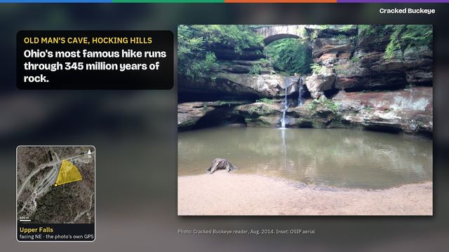
- Old Man's CaveOld Man's Cave is named for the recluse Richard Rowe. Ohio bought 146 acres there in 1924, the park's first land, and New Deal CCC and WPA crews built its trails.
Videos about Benton Township, Hocking County
Short videos we made from the old maps and records. All videos
How Benton Township, Hocking County began
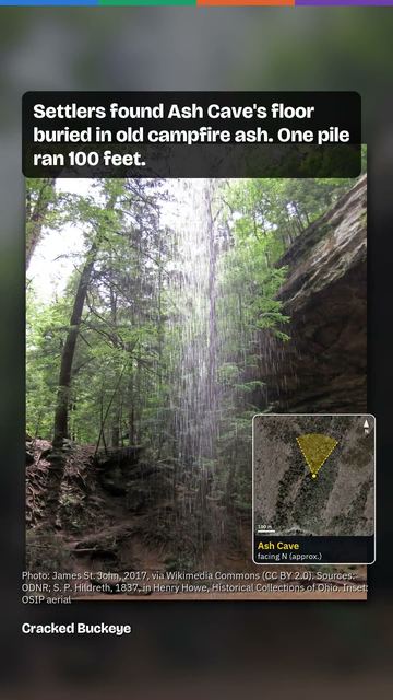
Benton Township, in southwestern Hocking County, has no incorporated municipality of its own but holds the two most visited features of Hocking Hills State Park. Old Man's Cave is a large recess cave in the half-mile gorge of Old Man's Creek, an informally named stream that joins Queer Creek and then Salt Creek, cut through the Black Hand Sandstone, about 345 million years old; it is named for a recluse, Richard Rowe, whom the sources place there anywhere from about 1796 to after the Civil War, and no deed, census or burial record for him is known. Ash Cave, the largest recess cave in Ohio, is named for the huge deposits of ash early settlers found on its floor. Archaeological evidence places Native American use of the Hocking Hills rock shelters as far back as roughly seven thousand years, with the Adena culture present in the Hocking River valley from about 500 BCE to 100 CE and Shawnee, Delaware, and Wyandot people hunting, traveling, and camping in the area through the 1600s and 1700s; an 1877 test excavation of Ash Cave's ash beds turned up arrows, pottery, flints, animal bone, and corn cobs consistent with centuries of use as a shelter and travel waypoint. The unincorporated community of South Bloomingville, settled by families such as the Ebys by 1820, is the township's only population center outside the park. Ohio began buying Hocking Hills land in 1924 and the Civilian Conservation Corps built much of the park's stonework and trails from 1933 on, turning what had been farmland and cut-over woods into the county's best-known tourist landscape.
Settled Christian Eby was in Hocking County by 1820 and living in Benton Township before 1838; his son was among the first settlers of Old Bloomingville, incorporated Organized as a township after Hocking County's formation on March 1, 1818; no specific organization date found.
Where the name comes from
No source found documents why this township is named Benton; four other Benton Townships exist elsewhere in Ohio (Monroe, Ottawa, Paulding, and Pike counties), and none of the sources checked give a naming rationale specific to Hocking County's Benton Township.
Before the town
Benton Township holds Old Man's Cave and Ash Cave, the two Hocking Hills sites with the strongest documented record of Native American use. Archaeological evidence shows American Indian peoples inhabiting the wider Hocking Hills region as early as roughly seven thousand years ago, and the Adena culture is recorded as thriving in the Hocking River valley from about 500 BCE to about 100 CE. By the 1600s and 1700s, Shawnee, Delaware (Lenape), and Wyandot people traveled through and lived in the region. Ash Cave in particular served as a shelter, a workshop for food preparation and toolmaking, and a resting point on a major trail linking Shawnee villages on the Scioto River with settlements toward the Kanawha River in present-day West Virginia; that same corridor was later used to move captives during frontier warfare. A test excavation of Ash Cave's ash deposits in 1877 found sticks, arrows, stalks of coarse grass, a wide variety of animal bones, bits of pottery, flints, and corn cobs beneath a pile of ash recorded at up to 100 feet long, 30 feet wide, and 3 feet deep -- read by researchers as the accumulated residue of Native campfires built up over centuries, though early theories also floated smelting or saltpeter production as alternative explanations for the ash. Old Man's Cave itself, in the gorge of Old Man's Creek, a small stream that joins Queer Creek and then Salt Creek, does not carry the same excavation record in sources reviewed, but sits along the same trail-and-shelter network.
Nations recorded here: Shawnee, Wyandot, Lenape (Delaware), Adena culture.
- Ash Cave (camp) — Benton Township, Hocking Hills State Park, prehistoric through 18th-century travel corridor; test-excavated 1877 (hockinghills.com)
- Old Man's Cave (other) — Benton Township, Hocking Hills State Park, prehistoric rock shelter; named for the recluse Richard Rowe, whose dates the sources disagree on (about 1796 to after the Civil War) (en.wikipedia.org)
Timeline
- — Hocking County, containing what becomes Benton Township, is organized from parts of Athens, Fairfield, and Ross counties.
- — According to the Hocking Hills tourism site, Richard Rowe's family comes to the Ohio Valley from Tennessee about this year, and Rowe later lives in the cave now named for him. Other sources place him there in the 1800s or after the Civil War, and no deed, census or burial record for him is known.
- — Christian Eby is recorded in Hocking County and living in Benton Township before 1838; his son is among the first settlers of Old Bloomingville, the community that becomes South Bloomingville.
- — A test excavation of the ash deposits at Ash Cave recovers sticks, arrows, coarse grass stalks, animal bones, pottery, flints, and corn cobs, evidence read as centuries of Native use of the shelter.
- — Bloomingville (Old Bloomingville) is recorded with a population of 165.
- — Ohio begins acquiring Hocking Hills land, including Old Man's Cave and Ash Cave, aiming to repair ground damaged by farming and wildfire.
- — The Civilian Conservation Corps builds trails and stone masonry at Old Man's Cave and Ash Cave.
- — An Ohio Bicentennial Commission historical marker for Old Man's Cave is erected, jointly sponsored by the Ohio Department of Natural Resources, the International Paper Company Foundation, and the Ohio Historical Society.
- — The U.S. Census records 780 residents in Benton Township.
Stories
The ash pile that would not explain itself
When Euro-American settlers first pushed into what became Benton Township, they found an enormous heap of ash on the floor of the great horseshoe-shaped rock shelter that came to be called Ash Cave: one pile alone was later measured at 100 feet long, 30 feet wide, and 3 feet deep, and settlers estimated several thousand bushels of ash in total. Nobody knew for certain how it got there. Some guessed at ore smelting, silver or lead; others thought of saltpeter works. When a test excavation finally dug into the ash in 1877, it turned up sticks, arrows, coarse grass stalks, a wide range of animal bones, pottery fragments, flint tools, and corn cobs, the kind of debris that piles up around a shelter used and reused as a camp, workshop, and waypoint for a very long time. The likeliest explanation, and the one most sources now favor, is the simplest: centuries of Native campfires, built again and again on the same spot because the huge overhang made it one of the best natural shelters in the entire Hocking Hills, on a trail that connected Shawnee villages on the Scioto River with points as far as the Kanawha River in present West Virginia.
The hermit who gave the cave its name, in several versions
Old Man's Cave, the most visited site in Hocking Hills State Park, takes its name not from any Native tradition but from a recluse named Richard Rowe, and the sources disagree on when he lived there and where he came from. The Hocking Hills tourism site says his family came to the Ohio Valley from Tennessee about 1796, that a trip up Salt Creek brought him to the gorge, and that he lived out his life in the cave and is buried beneath its ledge. Ohio Memory calls him a 19th-century hermit from Tennessee, and the state historical marker at the cave says only that he made it his home in the 1800s. The Ohio Geological Survey's 1975 guidebook to the park region, by Michael C. Hansen, calls him a fugitive from West Virginia who came after the Civil War, and the back of an old Columbus Metropolitan Library postcard of the cave also has the hermit arriving after the Civil War. No deed, census or burial record for Rowe is known, so every version rests on tradition. The gorge itself belongs to Old Man's Creek, a small, informally named stream that joins Queer Creek and then Salt Creek. It falls more than 100 feet in just over half a mile through the Black Hand Sandstone, laid down about 345 million years ago as a delta in a shallow sea, and the cave is hollowed from the rock's soft middle layer beneath a harder cap. Glacial ice came within about 6 miles of the park but never reached it; running water cut the gorge, probably in far greater volume while the ice sheets stood nearby, and the hemlocks in its cool, moist shade are glacial relicts. In 2003 the Ohio Bicentennial Commission, working with the state park system, the International Paper Company Foundation, and the Ohio Historical Society, placed a historical marker at the site explaining the sandstone geology that shaped it.
Photographs
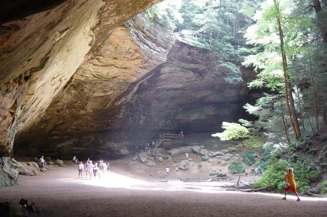
Photo: Dustin M. Ramsey, Wikimedia Commons, CC BY-SA 2.5 · Wikimedia Commons

Photo: Niagara66, Wikimedia Commons, CC BY-SA 4.0 · Wikimedia Commons
Local history sources: en.wikipedia.org · en.wikipedia.org · en.wikipedia.org · hockinghills.com · hmdb.org · remarkableohio.org · hockinghills.com · web.archive.org · sites.rootsweb.com · commons.wikimedia.org · commons.wikimedia.org
Water
Mostly private wells The water here
- Ross County Water Co. Inc74% of residentsTeays Valley Aquifer (buried valley groundwater)
- Laurelville, Vlg Of26% of residentsGroundwater wells (2 wells)
Hospitals, fire stations and more
Inside Benton Township, Hocking County's boundary: 1 fire or EMS station, 1 high-hazard dam, 1 public school, 2 public charging sites and 2 spill cases. Press a pin or a name for its whole record and its source.
Fire and EMS stations (1)
-
Laurelville Fire Department Station 2South Bloomingville
- Address
- 21771 State Highway 664, South Bloomingville, OH 43152
- Coordinates
- 39.42342, -82.59291
USGS National Map structures (source) ↗ Street map and directions ↗
Source: USGS National Map structures (most Ohio records last updated 2019 to 2022), checked against the Columbus and Cleveland station lists. The department that answers a call is set by jurisdiction and mutual aid, not by distance.
High-hazard dams (1)
-
Old Man's Cave Lake Dam PoorTributary To Queer Creek · condition: poor
- Hazard class
- High: a failure would probably cost a life
- Condition
- Poor (assessed 11/16/2023)
- River or stream
- Tributary To Queer Creek
- Purpose
- Water Supply;Recreation
- Type
- Earth
- Height
- 64 ft
- Storage
- 504 acre-feet
- Completed
- 1972
- Owner type
- State
- County
- Hocking County
- Nearest town (NID)
- South Bloomingville
- Last inspection
- 11/14/2022
- Emergency action plan
- Yes
- NID ID
- OH00249
National Inventory of Dams record ↗ National Inventory of Dams (source) ↗ Street map and directions ↗
Source: U.S. Army Corps of Engineers National Inventory of Dams, August 2026. "High hazard" rates what a failure would cost downstream, not how likely one is; the condition is the state's assessment.
Public schools (1)
-
Hocking Hills Elementary School4.5 of 5 stars · Logan
- Address
- 19197 State Route 664 S, Logan, OH 43138
- School district
- Logan-Hocking Local School District
- Kind (NCES)
- Regular School
- Students, 2023-24
- 120
- Teachers (full-time equivalent)
- 7.33
- Report card, 2025-26
- 4.5 of 5 stars
- Performance index
- 85.7%
- Ohio building IRN
- 000385
- NCES school ID
- 390442405283
NCES school record ↗ Ohio School Report Card ↗ Street map and directions ↗
Source: NCES EDGE public school locations 2024-25 and Common Core of Data 2023-24 (type, students, teachers); Ohio School Report Cards 2025-26 (Department of Education and Workforce), matched by name within the district.
Public EV charging (2)
-
HOCKING HILLS STATION 24 Level 2 · Logan
- Address
- 20020 OH-664, Logan, OH 43138
- Ports
- 4 Level 2
- Plugs
- J1772
- Network
- ChargePoint Network
- Hours
- 24 hours daily
- Phone
- 888-758-4389
Station Locator (NREL) ↗ Alternative Fuels Data Center (source) ↗ Street map and directions ↗
-
Inn and Spa at Cedar Falls - Tesla Destination2 Level 2 · Logan
- Address
- 21190 State Route 374, Logan, OH 43138
- Ports
- 2 Level 2
- Plugs
- J1772, Tesla (NACS)
- Network
- Tesla Destination
- Phone
- 877-798-3752
Station Locator (NREL) ↗ Alternative Fuels Data Center (source) ↗ Street map and directions ↗
Source: NREL Alternative Fuels Data Center station list (May 2026), public and open stations, the posts at one address counted as one site.
Spills reported since 2021 (2)
-
Natural Gas2025-03-18 · Benton Twp
- Reported
- 2025-03-18
- What spilled
- Natural Gas
- Where
- Benton Twp, Hocking County
- Ohio EPA district office
- SEDO
- Ohio EPA case number
- 2503EPA0000386
Ohio EPA spill reports (source) ↗ Street map and directions ↗
-
Sheen Rainbow / Hydrocarbon2025-03-12 · Benton Twp
- Reported
- 2025-03-12
- What spilled
- Sheen Rainbow / Hydrocarbon
- Largest amount reported
- 50 gallons
- Where
- Benton Twp, Hocking County
- Ohio EPA district office
- SEDO
- Ohio EPA case number
- 2503EPA0000340
Ohio EPA spill reports (source) ↗ Street map and directions ↗
Source: Ohio EPA emergency response spill reports, 2021 to September 2026, one point per case where Ohio EPA placed it. A report is what the caller or responder recorded; amounts are often blank or estimated.
Its ZIP codes
Each ZIP code that touches Benton Township, Hocking County, with the share of its residents who live here and the same headline figures as the ZIP page.
| ZIP | Share | Water | Radon | Home value | Schools | Flood |
|---|---|---|---|---|---|---|
| 43152 Benton Township and South Bloomingville | 56% | Mostly private wells | Too few radon tests | Median year built 1989 | Logan-Hocking Local · 3.5 stars overall | 6.9% of residents in the 1% floodplain |
| 45622 Swan Township and Creola | 8% | Mostly private wells | Too few radon tests | Appraisal records without year built | Vinton County Local · 3 stars overall | No digital FEMA flood map for this county |
| 43135 Perry Township and Laurelville | 3% | Mostly private wells | 4.7 pCi/L average radon | Median year built 1989 | Logan Elm Local · 3.5 stars overall | 6.3% of residents in the 1% floodplain |
Local government
Who holds office in Benton Township, Hocking County, how its elections and ballot issues came out, and the state auditor's record.
Money issues on the ballot since 2018: 1 of 1 passed.
Ballot issues
| Date | Issue | For | Against | Result |
|---|---|---|---|---|
| 2018-11-06 | Issue: Benton Township 1 mill Ren (1.0 mills) | 209 | 95 | Passed (68.75% for) |
Elections for office
| Date | Office | Candidates and votes |
|---|---|---|
| 2021-11-02 | Trustee (unofficial count) | Robbie Davis 183, 45.07%; Shawn D. Ervin 28, 6.9%; Scott Justice 59, 14.53%; David Seymour 136, 33.5% |
| 2019-11-05 | Trustee | Joe Eveland 111, 100.0% |
| 2019-11-05 | Fiscal Officer | Cindy Huffman 119, 100.0% |
| 2015-11-03 | Township Trustee (number of seats not on file, so winners are not marked) | Joe Eveland 218, 53.96%; Bruce Johnson 73, 18.07%; G. Dean Stevens 113, 27.97% |
| 2015-11-03 | Township Fiscal Officer | Cindy Huffman 331, 100.0% |
Winners in bold. Results from the county board of elections' official canvass unless marked.
Auditor of State record
- No fiscal caution, watch or emergency on the Auditor of State's lists.
- Financial Audit, 2024 to 2025, released 2026-08-27
- Agreed Upon Procedures, 2022 to 2023, released 2024-12-19
The county
Hocking County: 8 ZIP codes, 13 cities, villages and townships, 27,033 people.
Nearby places
Quick answers
What county is Benton Township, Ohio in?
Benton Township, Hocking County is a township in Hocking County, Ohio, with 780 residents.
When was Benton Township, Ohio founded?
Benton Township, Hocking County was settled Christian Eby was in Hocking County by 1820 and living in Benton Township before 1838; his son was among the first settlers of Old Bloomingville; incorporated Organized as a township after Hocking County's formation on March 1, 1818; no specific organization date found. Source
What ZIP code is Benton Township, Ohio?
Benton Township, Hocking County is served by ZIP codes 43152, 45622 and 43135; 43152 holds the largest share of its residents.
Where does Benton Township, Ohio get its water?
The main water source for Benton Township, Hocking County (Ross County Water Co. Inc): Mostly private wells.
Cite this page
Cite this page as:
Cracked Buckeye, "Benton Township, Hocking County", https://crackedbuckeye.com/place/benton-township-hocking-county/, built 2026-10-31, accessed [date].
How to cite · Report a correction · Built 2026-10-31
