How many oil and gas wells are here?
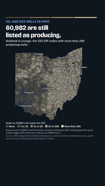
Wells from the Ohio Department of Natural Resources' public inventory of the 242,000 wells in its database (records before permitting began are incomplete, and estimates of wells ever drilled in Ohio run to 275,000). The map counts wells inside the ZIP; the card splits them into producing, plugged, horizontal shale (Utica and Marcellus), injection and orphan-program wells, and names the largest active operators.
1,229 of 1,233 ZIPs have data; median 14.
Legend
Map of Ohio by Oil and gas wells
Highest and lowest
Highest
- 45840 · Findlay4,515
- 45767 · Grandview Township and New Matamoras3,959
- 43793 · Woodsfield3,529
- 43138 · Logan3,475
- 43822 · Frazeysburg3,413
- 44654 · Berlin Township and Millersburg2,970
- 43724 · Olive Township and Caldwell2,906
- 43055 · Newark2,650
- 45745 · Salem Township and Lower Salem2,457
- 44691 · Wooster2,437
- 43754 · Summit Township and Lewisville2,328
- 43844 · Jefferson Township and Warsaw2,290
- 43758 · Malta Township and Malta2,227
- 45750 · Marietta2,211
- 44256 · Medina2,035
Lowest
- 43002 · Columbus and Amlin0
- 43007 · Taylor Township and Broadway0
- 43010 · Catawba0
- 43032 · Brown Township and Kilbourne0
- 43047 · Wayne Township and Mingo0
- 43070 · Adams Township and Rosewood0
- 43077 · Unionville Center0
- 43085 · Worthington and Columbus0
- 43101 · Adelphi0
- 43109 · Brice0
- 43116 · Commercial Point0
- 43117 · Darby Township and Derby0
- 43126 · Harrisburg0
- 43128 · Jeffersonville0
- 43142 · Milledgeville0
Source
ODNR Division of Oil and Gas Resources public well inventory (242,324 well heads, fetched 2026-09-08): wells inside each ZIP by status, horizontal shale wells, injection wells, orphan-program wells
More in Land, air and risk
RadonFloodHazard riskClimateAirToxic sitesToxic releasesDamsDisastersSpillsAbandoned minesSoilsParksWetlandsLand cover
Videos about oil and gas wells
Short videos we made from the old maps and records. All videos
Quick answers
Which Ohio ZIP code has the highest number of oil and gas wells?
ZIP code 45840 (Findlay, 4,515) ranks highest, followed by 45767 (Grandview Township and New Matamoras, 3,959) and 43793 (Woodsfield, 3,529). Wells from the Ohio Department of Natural Resources' public inventory of the 242,000 wells in its database (records before permitting began are incomplete, and estimates of wells ever drilled in Ohio run to 275,000).
Which Ohio ZIP code has the lowest number of oil and gas wells?
ZIP code 43002 (Columbus and Amlin, 0) ranks lowest, followed by 43007 (Taylor Township and Broadway, 0) and 43010 (Catawba, 0). Wells from the Ohio Department of Natural Resources' public inventory of the 242,000 wells in its database (records before permitting began are incomplete, and estimates of wells ever drilled in Ohio run to 275,000).
What is the typical number of oil and gas wells in Ohio?
Across Ohio ZIP codes: 1,229 of 1,233 ZIPs have data; median 14. Wells from the Ohio Department of Natural Resources' public inventory of the 242,000 wells in its database (records before permitting began are incomplete, and estimates of wells ever drilled in Ohio run to 275,000).
Cite this page
Cite this page as:
Cracked Buckeye, "Oil and gas wells", https://crackedbuckeye.com/topics/ogwells/, built 2026-10-31, accessed [date].
How to cite · Report a correction · Built 2026-10-31
