Local events in Wayne Township, Pickaway County
Nothing is posted for Wayne Township itself yet; here is what is on within 10 miles. All local events in Wayne Township, Pickaway County
Know a calendar we should watch? Send the link
Checked October 20; the events page is refreshed daily.
How Wayne Township, Pickaway County began
Wayne Township, along the west bank of the Scioto River south of Circleville, is one of Pickaway County's original townships, already settled and functioning as a unit of government before the county itself was organized in 1810; it takes its name from Gen. Anthony Wayne. Its first white settler, William King, arrived at Westfall in November 1798 to find the site still occupied by Native people in large numbers, and the 1880 county history identifies that same ground as Old Chillicothe, a Shawnee town where the Mingo leader Logan was living in 1774 during Lord Dunmore's War. Yellow Bud and Wolf creeks water the township's southwest corner, and today it holds Calamus Swamp, a rare, undisturbed glacial kettle lake, alongside quiet farmland and the Horsey-Barthelmas Farm on the National Register of Historic Places.
Settled November 1798 (William King and his wife Sarah, at Westfall), incorporated one of Pickaway County's original townships, in existence before the county itself was organized on March 1, 1810; the earliest surviving township record book is dated July 9, 1805.
Where the name comes from
The township was named, both county histories agree, "after the celebrated Indian fighter, General Anthony Wayne," the Revolutionary War general whose 1794 victory at Fallen Timbers and the resulting Treaty of Greenville opened this part of Ohio to settlement.
Before the town
According to the 1880 county history, the ground on which the village of Westfall stands was the site of Old Chillicothe, a Shawnee town the settlers' informants called "Chil-i-coth-e," the Indian word for town. It was here, that history states, that the Mingo leader Logan took refuge with his people in 1774 after being driven from his home in western Virginia by the campaign known as Lord Dunmore's War, and it was from here that he refused Lord Dunmore's invitation to the peace council at Camp Charlotte on Scippo Creek, some seven miles east, sending instead the speech that became known as "Logan's Lament," later reprinted by Thomas Jefferson. The same book records that "vast numbers of Indians" were still settled in and around Westfall and on the nearby Pickaway Plains at that time. This specific identification of Westfall with Logan's residence comes from local Pickaway County tradition as recorded in 1880; broader modern accounts of Logan and his speech, including the Ohio History Connection's own record, describe him more generally as a Mingo leader active around the Ohio Country in 1774 without fixing this exact spot as his home. When William King, the township's first settler, arrived at Westfall in November 1798, the county history says the site was still occupied by Indians "to the number of many thousands" and that King, of Quaker background, lived among his "red-skinned neighbors" without conflict. Separately, an earthwork enclosure known locally as the "Old Fort," its walls ten to twelve feet high and enclosing an area of roughly fifty acres, stood on the William Fleming farm on the Scioto River about two miles north of Yellow Bud, crossed by the old road to Franklinton; no source consulted attributes it to a specific prehistoric culture.
Nations recorded here: Shawnee, Mingo (Seneca-Cayuga).
- Old Chillicothe (Chil-i-coth-e) (village) — site of the later village of Westfall, on the Scioto River, occupied through 1774, Logan resident that year (archive.org)
- "Old Fort" earthwork (earthwork) — William Fleming farm, on the Scioto River about two miles north of Yellow Bud, crossed by the old Franklinton road, prehistoric, culture not stated (archive.org)
Timeline
- — According to the 1880 county history, the Mingo leader Logan is living at Old Chillicothe on the future site of Westfall when Lord Dunmore's War reaches its climax; he declines to attend Dunmore's peace council at Camp Charlotte, seven miles east, and sends his famous speech by messenger instead.
- — William King and his wife Sarah arrive from Kentucky and settle at Westfall, then still occupied by Native people in large numbers; King later establishes a ferry there.
- — The earliest township record book to survive a later fire is opened by the township treasurer; John Fleming, Philden Atchison, and Isaac Dumonds are recorded as trustees.
- — Fergus Moor, who had bought land around Westfall while living in Chillicothe, moves onto the property; the village there had already been laid out by Abel Westfall, who gave it his name, while the ground was still part of Hamilton County.
- — A second village, Montgomery, is platted on the Ohio Canal a short distance south of Westfall but never attracts enough settlement to develop.
- — The Union religious society is organized under Rev. Zachariah Wharton, meeting first in the William Hall schoolhouse before the completion of Union Chapel in 1860.
- — The Horsey-Barthelmas Farm, west of Circleville on State Route 104, is listed on the National Register of Historic Places.
- — Calamus Swamp, a 19-acre glacial kettle lake donated by Ada May Burke and Sally V. May, is dedicated as a Columbus Audubon nature preserve.
Stories
Logan's Town on the Scioto
The 1880 county history tells that the celebrated Mingo leader Logan, driven from his home in western Virginia by Lord Dunmore's War in 1774, took refuge with his people at a Shawnee town on the Scioto River the settlers later knew as Old Chillicothe, on the exact ground where the village of Westfall would stand. Lord Dunmore, encamped with his army seven miles east at Camp Charlotte on Scippo Creek after defeating the Shawnee and their allies, sent a messenger inviting the Native leaders to negotiate peace. Logan refused to go in person, but he sent, in the county history's words, "that celebrated speech, rendered immortal in Jefferson's Notes on Virginia": a lament for a family killed by white settlers and for a friendship with white neighbors he said he could no longer feel. The treaty that followed ended Lord Dunmore's War. By 1880 nothing remained at Westfall to mark the spot, and the county history mourns it in its own florid style: "the very desolation which now broods over the place seems to mourn for Logan."
A Quaker Family Among Thousands
William King and his wife Sarah Green King reached Westfall from Bourbon County, Kentucky, in November 1798 to find the site still thickly settled by Native people, whom the county history describes as numbering in the thousands in the area at that time. King and his wife, both of Quaker background, lived among their neighbors, the history says, without friction, and King later ran a ferry across the Scioto there when the growing settlement needed one. When Mrs. King died in 1833 and King himself about three years later, they were buried in the graveyard at Westfall, the first interments recorded in the township. Of their five children, most scattered west to Illinois and Indiana, but their daughter Jemima married Titus Dungan and stayed in Wayne Township for the rest of her life.
The Swamp the Burkes Would Not Drain
Calamus Swamp is a 19-acre kettle hole gouged out at the end of the last Ice Age, when a stranded block of glacial ice slowly melted in place, and it survives today as the only known kettle lake in central Ohio that has never been drained or otherwise disturbed. For more than a century it stayed intact because the Burke family, who owned it and the farmland around it, treated it as a treasure worth protecting rather than more acreage to till, at a time when nearly every other wetland like it in the county was ditched and plowed under. In 2000, Ada May Burke and Sally V. May gave the swamp to Columbus Audubon, which dedicated it as a public nature preserve on June 3 of that year, a rare central Ohio glimpse of the glacial landscape that once dotted the region with lakes like it.
Photographs
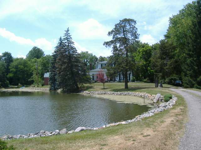
Photo: Aesopposea, via Wikimedia Commons, CC BY-SA 3.0 · Wikimedia Commons
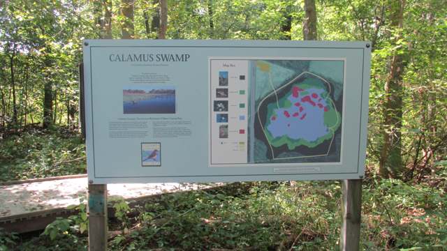
Photo: Aesopposea, via Wikimedia Commons, CC BY-SA 3.0 · Wikimedia Commons
Local history sources: archive.org · archive.org · en.wikipedia.org · en.wikipedia.org · en.wikipedia.org · en.wikipedia.org · en.wikipedia.org · en.wikipedia.org · ohioghosttowns.wordpress.com · commons.wikimedia.org · commons.wikimedia.org
Historic places
1 place in Wayne Township, Pickaway County on the National Register of Historic Places. Press a pin or a name for its whole record.
-
Horsey-Barthelmas FarmBuilding · Circleville · listed 1980
- Address
- W of Circleville on OH 104
- Where
- Circleville, Pickaway County · ZIP 43113
- What it is
- Building
- Listed on the National Register
- 1980
- NRIS reference number
- 80003210
- Coordinates
- 39.55518, -83.00883
National Register file (NPS) ↗ Search Wikipedia ↗ Street map and directions ↗ On the Cracked Buckeye map
Source: National Park Service, National Register of Historic Places point file. The listing year is shown where NPS's certification date agrees with the listing's reference number. Listing recognizes significance; it does not restrict a private owner.
Water
Sand-and-gravel wells in the Scioto River valley aquifer at the city's Island Road well field/treatment plant site, just east of the river. The water here
- Circleville City83% of residentsScioto River valley aquifer (sand & gravel wells)
- Earnhart Hill Water District13% of residentsScioto River valley (Teays) aquifer wells
- Williamsport Village3% of residentsGroundwater wells (2 wells)
- Darbyville Village0% of residentsGroundwater wells (3 wells)
- South Bloomfield Village0% of residentsGroundwater wells (3 wells)
- Ross County Water Co. Inc0% of residentsTeays Valley Aquifer (buried valley groundwater)
Hospitals, fire stations and more
Inside Wayne Township, Pickaway County's boundary: 2 shale and injection wells and 1 Superfund site. Press a pin or a name for its whole record and its source.
Shale and injection wells (2)
-
Burke-May Unit (Swiw # 2) 1 InjectionInjection well (Class II)
- What it is
- Injection well (Class II)
- Operator
- Layline Oil and Gas Llc
- County
- Pickaway County
- API well number
- 34129200880000
- Coordinates
- 39.58235, -83.00054
ODNR oil and gas wells (source) ↗ Street map and directions ↗
-
Gifford C & B (Swiw #10) 3 InjectionInjection well (Class II)
- What it is
- Injection well (Class II)
- Operator
- Chuck Henry Energy Llc
- County
- Pickaway County
- API well number
- 34129202510000
- Coordinates
- 39.60150, -83.03444
ODNR oil and gas wells (source) ↗ Street map and directions ↗
Source: ODNR Division of Oil and Gas Resources well inventory (September 2026): drilled Utica, Marcellus and horizontal wells and Class II injection wells not plugged. Older vertical wells are on the full map.
Superfund sites (1)
-
B & E LandfillSuperfund program · Wayne Twp Circleville
- Address
- East of State Road 104, Wayne Twp Circleville, OH 43113
- County
- Pickaway County
- Status
- Superfund program site, not on the National Priorities List
- EPA program ID
- OHD980794648
- EPA registry ID
- 110060850306
EPA facility record ↗ EPA Facility Registry Service (source) ↗ Street map and directions ↗
Source: EPA Facility Registry Service, Superfund (SEMS) and National Priorities List sites. Many program sites were assessed and needed no cleanup.
Its ZIP codes
Each ZIP code that touches Wayne Township, Pickaway County, with the share of its residents who live here and the same headline figures as the ZIP page.
| ZIP | Share | Water | Radon | Home value | Schools | Flood |
|---|---|---|---|---|---|---|
| 43113 Circleville | 2% | Sand-and-gravel wells in the Scioto River valley aquifer at the city's Island Road well field/treatment plant site, just east of the river. | 8.0 pCi/L average radon | Median year built 1967 | Circleville City · 3 stars overall | 7.0% of residents in the 1% floodplain |
| 43164 Williamsport | 1% | Mostly private wells | 2.5 pCi/L average radon | Median year built 1964 | Westfall Local · 3 stars overall | 6.2% of residents in the 1% floodplain |
Local government
Who holds office in Wayne Township, Pickaway County, how its elections and ballot issues came out, and the state auditor's record.
Elections for office
| Date | Office | Candidates and votes |
|---|---|---|
| 2017-11-07 | Township Trustee | Kenneth E, Davis 101, 58.72%; Brenna C. Gibson 71, 41.28% |
Winners in bold. Results from the county board of elections' official canvass unless marked.
Auditor of State record
- No fiscal caution, watch or emergency on the Auditor of State's lists.
- Basic Audit, 2023 to 2024, released 2025-09-02
The county
Pickaway County: 8 ZIP codes, 22 cities, villages and townships, 56,176 people.
Nearby places
Quick answers
What county is Wayne Township, Ohio in?
Wayne Township, Pickaway County is a township in Pickaway County, Ohio, with 427 residents.
When was Wayne Township, Ohio founded?
Wayne Township, Pickaway County was settled November 1798 (William King and his wife Sarah, at Westfall); incorporated one of Pickaway County's original townships, in existence before the county itself was organized on March 1, 1810; the earliest surviving township record book is dated July 9, 1805. Source
How did Wayne Township, Ohio get its name?
The township was named, both county histories agree, "after the celebrated Indian fighter, General Anthony Wayne," the Revolutionary War general whose 1794 victory at Fallen Timbers and the resulting Treaty of Greenville opened this part of Ohio to settlement. Source
Where does Wayne Township, Ohio get its water?
The main water source for Wayne Township, Pickaway County (Circleville City): Sand-and-gravel wells in the Scioto River valley aquifer at the city's Island Road well field/treatment plant site, just east of the river.
Cite this page
Cite this page as:
Cracked Buckeye, "Wayne Township, Pickaway County", https://crackedbuckeye.com/place/wayne-township-pickaway-county/, built 2026-10-31, accessed [date].
How to cite · Report a correction · Built 2026-10-31
