Local events in Circleville
44 events in the next 90 days from 4 public calendars. All local events in Circleville
Checked October 20; the events page is refreshed daily.
Lakes near Circleville
The history under the water: the valley before, the dam, the stories. All Ohio lakes
Deep dives about Circleville
Long reads built from maps, newspapers and public records. All deep dives
- Ohio's Ice Age glaciersIce a mile thick once buried the Lake Erie basin. Three glaciations reshaped Ohio, rerouted its rivers, and left the farmland Ohioans still farm today.
- Ohio's Native Nations, 1650-1843Ohio's historic Native nations were mostly newcomers of the 1720s-1750s, not ancient residents, and by 1843 every one had been forced out of the state.
- Ohio's Road to StatehoodFrom the French and Indian War through St. Clair's defeat to a one-vote loss of Black suffrage, Ohio's path to statehood in 1803 was neither clean nor certain.
- The Hopewell CultureOhio's Hopewell people built moon-aligned earthworks around AD 90-430, moved Yellowstone obsidian 1,500 miles, and left a 2023 UNESCO World Heritage Site.
- The Mound Builder MythOhio's earthworks were long blamed on a vanished 'lost race,' a myth that helped justify Indian Removal and outlived its 1894 federal debunking.
Notable people from Circleville
Ohioans tied to this place, each with a sourced profile. All notable Ohioans
History from Circleville
People and inventions tied to this place, each with its sources. All people · All inventions
How Circleville began
Circleville, the Pickaway County seat, was platted in 1810 directly on top of a Hopewell-era earthwork of a great circle joined to a square, and its first streets ran in concentric rings around an octagonal courthouse standing at the exact center of the ancient circle. County commissioners chose the site partly to protect the ancient monument, but by the 1830s residents found the round lots and the animal-fouled green around the courthouse a nuisance, and the chartered Circleville Squaring Company spent eighteen years, 1837 to 1856, converting the town to an ordinary street grid, erasing all but a scrap of embankment in the process -- one of the best-documented deliberate destructions of a prehistoric earthwork in North America. The Ohio Canal reached the town in 1831 after Circleville residents raised money to beat a rival crossing point, and canal and later rail trade in grain, pork, and lard built a substantial market town of roughly 3,000 people by the mid-1840s. Circleville is also the birthplace of bandleader Ted Lewis (1890) and, since 1903, home to the Circleville Pumpkin Show, billed as "the greatest free show on earth," and it hosts Ohio Christian University, founded in 1948 as a small Bible college.
Settled No separate settlement predates the town; when the site was chosen in 1810, Jacob Zeiger's farm, log cabin, and a part-finished new house stood on the ground, inside the ancient earthwork, platted 1810 (Daniel Dreisbach surveyed and laid out the town after his July 25, 1810 appointment as director; the first lots were sold at auction September 10-12, 1810), incorporated 1814 as a town; became a city of the third class on March 25, 1853, by Daniel Dreisbach, director appointed by the Pickaway County court of common pleas to buy the ground and lay out the town.
Where the name comes from
Circleville was named for the shape of its original town plan: the county-seat commissioners in 1810 chose ground occupied by an intact prehistoric earthwork -- a great circle joined to a square -- and Daniel Dreisbach laid the new town's central streets out in two concentric circles around the circle's center, with the courthouse itself built there. The 1906 county history states plainly that the town "derives its name from the fact that the original town was laid out within a circular enclosure, formed by a high embankment, that was found here when the first settlement was made."
Before the town
Circleville sits directly on top of one of Ohio's most thoroughly recorded Hopewell-era earthworks (Ohio Hopewell dated by archaeologists to roughly 200 BCE-500 CE): a great circle joined on the east to a square, which the county's early settlers found still standing when the town was platted in 1810. Caleb Atwater, a Circleville postmaster and later state legislator, surveyed and described the works around 1820 (reprinted in the 1906 county history under the title "Western Antiquities," dated there to 1833); he measured the circular fort at 69 rods (about 1,139 feet) across, defended by a double wall and ditch with a single entrance, and the adjoining square fort at an exact 55 rods (about 908 feet) on a side, with eight gateways, each originally guarded by a small mound. Atwater watched workmen open the large mound near the circle's center and recorded two burned skeletons, quantities of arrowheads, an elk-horn knife or sword handle with a silver ferule, and a large sheet-mica "mirror" with an oxidized iron plate -- offering items that reached Circleville from far outside the Scioto Valley, as Hopewell sites elsewhere are known to do. By 1848, when Ephraim Squier and Edwin Davis reproduced a reduced plan of "the celebrated Circleville work" in their landmark "Ancient Monuments of the Mississippi Valley," they noted the earthwork was already "almost entirely destroyed"; the county history of 1880 records that grading for streets and lots had by then effaced every trace but a shallow hollow behind the courthouse and a short stretch of embankment at Franklin and Pickaway streets, both since lost. No Native town or camp is recorded on the town site itself in the historic era; the nearest historic-era Native settlements were the Shawnee towns of the Pickaway Plains, beginning about three miles south of Circleville along Scippo Creek -- Cornstalk's Town and, just south of it, the Grenadier Squaw's Town of Nonhelema, Cornstalk's sister -- and Lord Dunmore's War was ended nearby by the October 19, 1774 peace conference at Camp Charlotte, also on Scippo Creek, where Cornstalk negotiated with Lord Dunmore. By 1880 the site of the Grenadier Squaw's Town was farmed by Jacob Hitler, a member of the Pickaway County Hitler family (descended from a German immigrant, George Hitler Sr., who settled near Circleville in 1799 and is unrelated to Adolf Hitler) whose name still marks roads, a pond, and a cemetery around the city.
Nations recorded here: Hopewell culture, Shawnee.
- Circleville Circle and Square Earthworks (earthwork) — site of downtown Circleville, centered near the present crossing of Court and Main streets, Hopewell culture, Ohio Hopewell dated approximately 200 BCE-500 CE; intact until town platted in 1810, incrementally destroyed 1837-1856, no longer visible today (archive.org)
- Central mound of the circular fort (mound) — near the center of the circular earthwork, at the site later occupied by Circleville's town center, prehistoric (Hopewell); opened and its contents recorded by Caleb Atwater in the early 19th century, entirely removed by the time of his account (archive.org)
- Cornstalk's Town (village) — on Scippo Creek, Pickaway Plains, a few miles south of Circleville, north of where the Chillicothe pike crosses the creek, occupied in the 1770s; abandoned area after Lord Dunmore's War and the 1774 Camp Charlotte peace (archive.org)
- Nonhelema's Town (recorded by settlers as Grenadier Squaw's Town) (village) — on Scippo Creek, just south of Cornstalk's Town, south of the Chillicothe pike bridge; site later farmed by Jacob Hitler, occupied in the 1770s, home of Nonhelema (the "Grenadier Squaw"), Cornstalk's sister (archive.org)
- Camp Charlotte (treaty) — on Scippo Creek, on the old Winship farm in the southwest quarter of section twelve, a few miles south of Circleville, October 19, 1774; peace conference ending Lord Dunmore's War (en.wikipedia.org)
Timeline
- — The Hopewell culture builds a great circular earthwork joined to a square on the ground that later becomes downtown Circleville; Caleb Atwater's early survey measures the circle at 69 rods (about 1,139 feet) across and the square at an exact 55 rods (about 908 feet) on a side.
- — The Treaty of Camp Charlotte, negotiated on Scippo Creek a few miles south of the future Circleville between Lord Dunmore and the Shawnee leader Cornstalk, ends Lord Dunmore's War.
- — The first U.S. land entries are made within what becomes Circleville township: Jacob Zeiger Sr. enters sections 19 and 20 and Samuel Hill enters section 29 on May 7, and Robert F. Slaughter enters section 32 on June 9.
- — The Ohio General Assembly creates Pickaway County.
- — The Assembly appoints David Bradford, George Jackson, and John Pollock to choose the site of the new county's seat of justice.
- — The commissioners select the site of the intact circular-and-square earthwork on the Zeiger and Watt lands for the county seat, reportedly hoping a town built around the ancient works would help preserve them.
- — The court of common pleas appoints Daniel Dreisbach director, bonded for $10,000, to purchase the earthwork ground and lay out the town of Circleville.
- — The first lots of the new town are sold at auction -- 29 the first day and 11 the next -- and by winter about forty families have settled in Circleville.
- — Circleville is formally incorporated as a town, and its first courthouse -- octagonal, built of brick with a central tower -- opens for court business at the exact center of the circle, at the present crossing of Court and Main streets.
- — Caleb Atwater moves to Circleville and becomes its postmaster; within a few years he will publish the first scientific description of the town's earthworks.
- — The Olive Branch, Circleville's first newspaper, prints its first number; it is the direct ancestor of the present-day Circleville Herald.
- — Caleb Atwater publishes "Description of the Antiquities Discovered in the State of Ohio," including the first scientific survey of the Circleville earthworks; the county's 1906 history reprints his account, citing it there under the title "Western Antiquities," dated 1833.
- — Facing a canal survey that would route the Ohio Canal past a cheaper crossing at Keffer's Point instead of Circleville, the town's citizens raise several thousand dollars in a week to cover the extra construction cost and win the canal for their town.
- — The canal boat Governor Brown, carrying Pickaway County passengers, arrives in Columbus from Circleville, marking completion of the Ohio Canal connection and opening decades of canal trade in grain, pork, and lard.
- — The Ohio legislature passes the first "enabling act" allowing Circleville property owners to petition to square off sections of the town's circular plan.
- — The southeast quarter of the circle is vacated and squared in March and the northwest quarter in September, the first two sections of the old circular town plan to become an ordinary street grid.
- — The old octagonal courthouse at the center of the vanishing circle is torn down; for six years afterward, court is held in temporary quarters, including the Lutheran and United Brethren churches.
- — A new courthouse, 45 by 105 feet with a columned front and tower, is built at Court and Franklin streets -- no longer at the vanished circle's center -- at a cost of $45,000, with N. B. Kelly of Columbus as architect.
- — With about 3,000 residents, Circleville ships tens of thousands of barrels of flour and pork and 40,000 slaughtered hogs by canal in a single winter, according to a gazetteer description of the town that year.
- — Ephraim Squier and Edwin Davis publish "Ancient Monuments of the Mississippi Valley," reproducing a reduced plan of "the celebrated Circleville work" and noting that by then it was "almost entirely destroyed."
- — The newly organized Circleville Squaring Company, led by John Cradlebaugh, E. B. Olds, and Francis Kinnear, buys the county's interest in the northeast quarter of the old circle for $75 and lays it out in square lots.
- — Circleville becomes a city.
- — The southwest quarter of the circle, the last remaining section, is finally squared, closing an eighteen-year process; the same year the Cincinnati and Zanesville (Muskingum Valley) railroad becomes the first to reach Circleville.
- — Theodore Leopold Friedman -- later famous as bandleader Ted Lewis -- is born in Circleville, where his father runs Friedman's Bazaar dry-goods store.
- — Memorial Hall, a Richardsonian Romanesque war memorial housing the public library and the city's largest meeting hall, is completed in Circleville.
- — The 1847 courthouse is remodeled by architects Weary and Kramer, its Greek Revival original almost entirely concealed behind the present exterior.
- — Circleville mayor George R. Haswell sets up a small pumpkin-and-corn display outside his store to mark the harvest, the seed of what grows into the Circleville Pumpkin Show.
- — Mount of Praise Bible College is founded at Circleville and soon renamed Circleville Bible College; it becomes Ohio Christian University in 2006.
- — A dynamite bomb explodes inside Bingman's Drug Store on West Main Street during a struggle with staff, destroying the store and neighboring buildings, killing five people, and injuring nearly thirty.
- — Circleville residents begin receiving anonymous, threatening letters from a writer identified only as "the Writer"; the same year, Ted Lewis's widow Adah opens the Ted Lewis Museum across from his birthplace.
Stories
A Town Platted Inside a Fort
When Pickaway County's commissioners went looking for a county seat in the spring of 1810, they chose ground a few miles east of the Scioto River that still carried a nearly intact ancient earthwork -- a great circle joined to a square, its walls in places standing several feet high and thick with old-growth timber. The 1880 county history says plainly that the commissioners, in preferring this site to others they inspected, "no doubt thought they were doing that which would serve to preserve the ancient monuments from demolition and ruin." On July 25, 1810, the court appointed Daniel Dreisbach director, bonded for $10,000, to buy the roughly 200 acres from the heirs of Jacob Zeiger and from Samuel Watt for between $800 and $900, survey it, and sell lots. Dreisbach worked fast: by the appointed sale day in September, cabins were going up before the sun set, and by winter about forty families had moved into the new town of Circleville, built in concentric rings around the very earthwork the founders hoped their presence would protect.
What Caleb Atwater Found at the Center
Caleb Atwater, who moved to Circleville in 1815 to serve as its postmaster, made the first careful survey of the town's ancient works and became one of the first Americans to write about them scientifically. He measured the circular fort at 69 rods across, defended by a double wall and a deep ditch with only one narrow entrance, and the adjoining square fort at an exact 55 rods on a side, with eight gateways each once guarded by a small earthen mound. Near the center of the circle stood a large mound, and Atwater was present when workmen removed it entirely: inside, he recorded two burned human skeletons, a great quantity of arrowheads, an elk-horn knife or sword handle banded in silver, and -- laid on charcoal and ashes beside the second skeleton -- a large sheet of mica "answering the purpose" of a mirror, with an oxidized plate of iron resting on it. Atwater sent the knife handle to Charles Willson Peale's museum in Philadelphia and kept a fragment of the mica mirror himself, and his description, later reprinted in the county's 1906 history, remains one of the few detailed accounts of what the mound builders left behind before Circleville's growth erased the evidence for good.
Eighteen Years to Square a Circle
Not everyone loved living on a circle. By the 1830s, Circleville residents complained that the pie-shaped lots were awkward to build on and that the open green around the courthouse, at the exact center of the old earthwork, had become a favorite spot for farmers to hitch their teams -- drawing hogs and other loose animals along with them. In 1837 and 1838 the Ohio legislature passed acts letting property owners petition to convert their quarter of the circle to a standard grid, and the southeast and northwest quarters were squared that same year; eleven years passed before the Circleville Squaring Company, organized by John Cradlebaugh, E. B. Olds, and Francis Kinnear, took up the northeast quarter in 1849, and the last piece, the southwest quarter, was not finally deeded until March 6, 1856 -- eighteen years after the process began. The old octagonal courthouse that had stood at the circle's dead center since 1814 was torn down around 1840, and a new one went up in 1845-47 at Court and Franklin streets, no longer in the middle of anything. Only one prominent building, the old Dr. Hawkes residence, still stands at the odd forty-five-degree angle of a vanished street called Bastile Avenue, and the county history notes that by 1880 nothing else remained of the ancient circle and square but a shallow hollow behind the courthouse and a short stretch of embankment at Franklin and Pickaway streets -- both since lost as well.
Buying the Canal Route
In May 1828, with the route of the Ohio Canal south of Columbus still undecided, Circleville's future hung on a week's negotiation. Engineers had narrowed the crossing of the Scioto to two points: Keffer's, which would save the state about $7,000 in construction costs, or Circleville, which would cost more but keep the canal beside the town. The canal commissioners, Kelley and Williams, told Circleville's citizens that if they would raise half of that extra $7,000 themselves, they could have the route -- and in less than a week the town's newspaper was able to announce success. The Ohio Canal reached completion past Circleville in September 1831, and on the 23rd the boat Governor Brown arrived in Columbus carrying Pickaway County leaders to a twenty-four-gun salute and a public celebration; canal warehouses along the Circleville waterfront went on to ship enormous quantities of the county's wheat, corn, pork, and lard for the next quarter century.
Nonhelema's Town on Scippo Creek
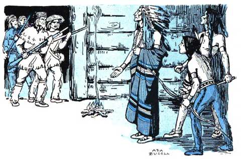
Three miles south of Circleville, on Scippo Creek, stood two Shawnee towns of the 1770s: Cornstalk's Town, named for the Shawnee leader Cornstalk, and just south of it the Grenadier Squaw's Town, home to his sister Nonhelema, whom the British nicknamed for her unusual height. Lord Dunmore's War, fought that decade over Virginia's push into Kentucky hunting grounds, ended nearby on October 19, 1774, when Cornstalk negotiated peace with Lord Dunmore's Virginia militia at Camp Charlotte, also on Scippo Creek. By the time Pickaway County's history was written in 1880, the site of the Grenadier Squaw's Town belonged to a farmer named Jacob Hitler, part of a large Pickaway County family descended from George Hitler Sr., a German immigrant who had settled near Circleville in 1799 -- a family whose name still marks two roads, a pond, a park, and a cemetery around the city today, and which Circleville's own historical record is careful to note has no connection whatsoever to the Adolf Hitler whose surname became infamous more than a century later.
Is Everybody Happy?
Theodore Leopold Friedman was born in Circleville on June 6, 1890, the son of a merchant who ran Friedman's Bazaar, a ladies' bargain store on the town square. As Ted Lewis, he became one of the first Northern bandleaders to popularize New Orleans-style jazz, recording with Earl Fuller's band starting in 1917 despite a Victor Records catalog description of his clarinet as sounding like "a dog in his dying anguish." He refined his act into something bigger than the music -- a battered top hat, a cracked-voice delivery, and the catchphrase "Is everybody happy?" -- and by the early 1920s his band rivaled Paul Whiteman's, at various points featuring young musicians like Benny Goodman and Muggsy Spanier. Lewis died in New York in 1971 at 81 and is buried in Circleville's Forest Cemetery, his top hat and cane carved into his headstone; his widow, Adah, opened the Ted Lewis Museum in his hometown in 1977, across from the house where he was born.
The Greatest Free Show on Earth
In October 1903, Circleville mayor George R. Haswell set out a small display of pumpkins and corn in front of his store to mark the season's harvest. The idea caught on with other merchants, a carnival ride was added by 1905, and within a few years the display had outgrown the storefront and moved into the city's streets. By its centennial in 2006 the Circleville Pumpkin Show had grown into one of the largest festivals in the country, drawing several hundred thousand visitors over four October days for giant-pumpkin weigh-ins, seven parades, and a pumpkin pie big enough to need its own street tent, all of it, true to its billing, free to attend.
The Writer
Starting in 1977, Circleville households began receiving anonymous letters, signed only "the Writer," accusing local residents of affairs and other misdeeds with unsettling specificity. The letters focused especially on Mary Gillispie, a school bus driver, and on January 27, 1983, a sign appeared along her bus route bearing obscene accusations about her thirteen-year-old daughter; a booby-trapped gun rigged to the sign wounded no one when Gillispie's brother-in-law, Paul Freshour, tried to disable it, but Freshour was convicted in 1984 and sentenced to ten years in prison for the device. The letters continued arriving throughout his imprisonment, and only after Freshour's 1994 release did they finally stop. As of the most recent update to Circleville's own historical record, in 2026, the identity of the Writer has never been established.
Death at Bingman's Drug Store
In April 1967, Lee Holbrook -- the husband of an employee at Bingman's Drug Store on West Main Street -- carried a wooden box packed with bundled dynamite into the store. During a struggle with staff who tried to stop him, the dynamite detonated, destroying the drug store and several neighboring buildings on the block. Holbrook and four store employees died in the blast and the fire that followed, and nearly thirty other people were injured, making it one of the deadliest single incidents in Circleville's history.
Photographs
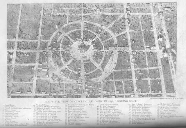
Photo: unknown surveyor, via 99percentinvisible.org and Wikimedia Commons, public domain · Wikimedia Commons
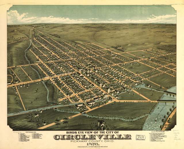
Photo: A. Ruger and J. J. Stoner, Krebs Lithographing Co., Cincinnati; Library of Congress Geography and Map Division, public domain · Wikimedia Commons
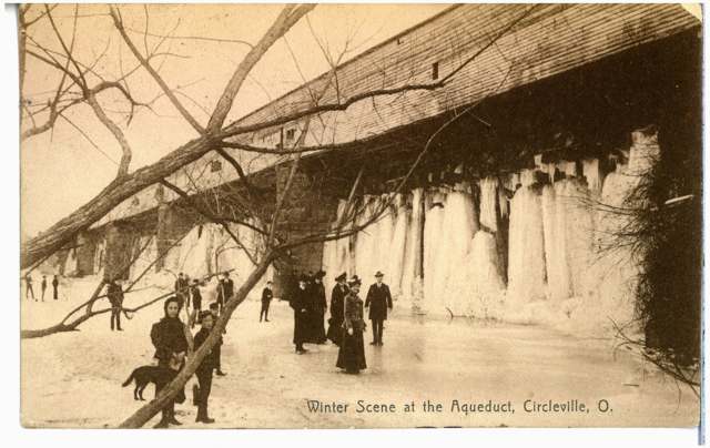
Photo: Columbus Metropolitan Library, via DPLA/Ohio Digital Network, no known copyright restrictions · Wikimedia Commons
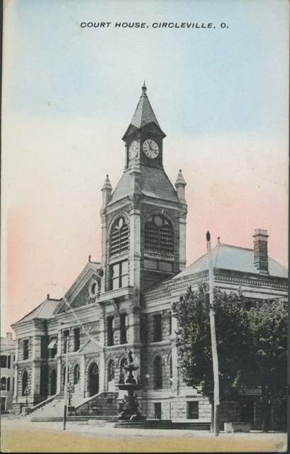
Photo: Columbus Metropolitan Library, via DPLA/Ohio Digital Network, no known copyright restrictions · Wikimedia Commons
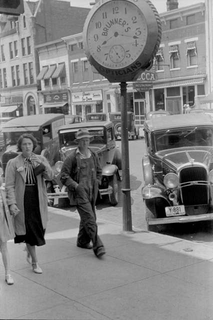
Photo: Ben Shahn, U.S. Farm Security Administration, via the Library of Congress, public domain · Wikimedia Commons
Local history sources: archive.org · archive.org · archive.org · archive.org · en.wikipedia.org · en.wikipedia.org · en.wikipedia.org · en.wikipedia.org · en.wikipedia.org · en.wikipedia.org · en.wikipedia.org · en.wikipedia.org · en.wikipedia.org · en.wikipedia.org · en.wikipedia.org · en.wikipedia.org · en.wikipedia.org · en.wikipedia.org · en.wikipedia.org · sciotopost.com · commons.wikimedia.org · commons.wikimedia.org · commons.wikimedia.org · commons.wikimedia.org · commons.wikimedia.org
Historic places
8 places in Circleville on the National Register of Historic Places. Press a pin or a name for its whole record.
-
Anderson, William Marshall, HouseBuilding · Circleville · listed 1979
- Address
- 131 W. Union St
- Where
- Circleville, Pickaway County · ZIP 43113
- What it is
- Building
- Listed on the National Register
- 1979
- NRIS reference number
- 79001925
- Coordinates
- 39.59912, -82.94721
National Register file (NPS) ↗ Search Wikipedia ↗ Street map and directions ↗ On the Cracked Buckeye map
-
Circleville High SchoolBuilding · Circleville · listed 2015
- Address
- 520 S. Court St.
- Where
- Circleville, Pickaway County · ZIP 43113
- What it is
- Building
- Listed on the National Register
- 2015
- NRIS reference number
- 15000576
- Coordinates
- 39.59480, -82.94702
National Register file (NPS) ↗ Search Wikipedia ↗ Street map and directions ↗ On the Cracked Buckeye map
-
McCrea, Matthew, HouseBuilding · Circleville · listed 1988
- Address
- 428 E. Main St.
- Where
- Circleville, Pickaway County · ZIP 43113
- What it is
- Building
- Listed on the National Register
- 1988
- NRIS reference number
- 88001714
- Coordinates
- 39.60400, -82.93512
National Register file (NPS) ↗ Search Wikipedia ↗ Street map and directions ↗ On the Cracked Buckeye map
-
Memorial HallBuilding · Circleville · listed 1980
- Address
- 165 E. Main St.
- Where
- Circleville, Pickaway County · ZIP 43113
- What it is
- Building
- Listed on the National Register
- 1980
- NRIS reference number
- 80003211
- Coordinates
- 39.60082, -82.94213
National Register file (NPS) ↗ Search Wikipedia ↗ Street map and directions ↗ On the Cracked Buckeye map
-
Morris HouseBuilding · Circleville · listed 1979
- Address
- 149 W. Union St
- Where
- Circleville, Pickaway County · ZIP 43113
- What it is
- Building
- Listed on the National Register
- 1979
- NRIS reference number
- 79001926
- Coordinates
- 39.59842, -82.94556
National Register file (NPS) ↗ Search Wikipedia ↗ Street map and directions ↗ On the Cracked Buckeye map
-
Saint Philip's Episcopal ChurchBuilding · Circleville · listed 1986
- Address
- 129 W. Mound St.
- Where
- Circleville, Pickaway County · ZIP 43113
- What it is
- Building
- Listed on the National Register
- 1986
- NRIS reference number
- 86001064
- Coordinates
- 39.59984, -82.94723
National Register file (NPS) ↗ Search Wikipedia ↗ Street map and directions ↗ On the Cracked Buckeye map
-
Walling, Ansel T., HouseBuilding · Circleville · listed 1987
- Address
- 146 W. Union St.
- Where
- Circleville, Pickaway County · ZIP 43113
- What it is
- Building
- Listed on the National Register
- 1987
- NRIS reference number
- 87002145
- Coordinates
- 39.59964, -82.94839
National Register file (NPS) ↗ Search Wikipedia ↗ Street map and directions ↗ On the Cracked Buckeye map
-
Watt-Groce-Fickhardt HouseBuilding · Circleville · listed 1985
- Address
- 360 E. Main St.
- Where
- Circleville, Pickaway County · ZIP 43113
- What it is
- Building
- Listed on the National Register
- 1985
- NRIS reference number
- 85001804
- Coordinates
- 39.60002, -82.93873
National Register file (NPS) ↗ Search Wikipedia ↗ Street map and directions ↗ On the Cracked Buckeye map
Source: National Park Service, National Register of Historic Places point file. The listing year is shown where NPS's certification date agrees with the listing's reference number. Listing recognizes significance; it does not restrict a private owner.
Water
Sand-and-gravel wells in the Scioto River valley aquifer at the city's Island Road well field/treatment plant site, just east of the river. The water here
- Circleville City86% of residentsScioto River valley aquifer (sand & gravel wells)
- Earnhart Hill Water District13% of residentsScioto River valley (Teays) aquifer wells
- South Bloomfield Village0% of residentsGroundwater wells (3 wells)
- Ross County Water Co. Inc0% of residentsTeays Valley Aquifer (buried valley groundwater)
Hospitals, fire stations and more
Inside Circleville's boundary: 1 hospital, 1 health center, 2 dialysis centers, 3 nursing homes, 2 fire and EMS stations, 1 college, 4 public schools, 2 libraries, 3 museums, 2 police stations, 2 public charging sites, 2 Superfund sites, 9 Toxics Release Inventory facilities and 9 spill cases. Press a pin or a name for its whole record and its source.
Hospitals (1)
-
Ohiohealth Berger HospitalGeneral hospital · Circleville
- What it is
- General hospital
- Address
- 600 North Pickaway Street, Circleville, OH 43113
- County
- Pickaway County
- Beds
- 82
- Helipad
- Yes
- Ownership
- Government - local
- Medicare overall rating
- 3 of 5 stars
- Emergency department (Medicare)
- Yes
- Medicare reports it as
- Berger Hospital
- Phone
- (740) 474-2126
- Medicare ID
- 360170
Medicare Care Compare ↗ Hospital's website ↗ Where HIFLD got this record ↗ HIFLD hospitals (source) ↗ Street map and directions ↗
Source: HIFLD hospitals inventory via FEMA (closed hospitals it still lists left out, hospitals opened since added), with Medicare Care Compare ratings matched by name and address.
Community health centers (1)
-
PrimaryOne Health CirclevilleHealth center · Circleville
- Run by
- a federally qualified health center
- Setting
- Hospital
- City
- Circleville
- Coordinates
- 39.61034, -82.93621
Find a Health Center (HRSA) ↗ HRSA data (source) ↗ Street map and directions ↗
Source: HRSA health center service delivery sites, active, September 2026 (school-based sites left out). Health centers see patients whether or not they have insurance, with fees on a sliding scale.
Dialysis centers (2)
-
Fmc - Circleville DialysisDialysis · Circleville
- Address
- 790 North Court Street, Circleville, OH 43113
- Dialysis stations
- 12
- Medicare star rating
- 3 of 5 stars
- Services
- in-center hemodialysis
- Ownership
- for profit
- Chain
- Fresenius Medical Care
- Medicare certified since
- 1996-04-17
- Phone
- (740) 477-7225
- Medicare ID
- 362557
Medicare Care Compare ↗ CMS dialysis facility list (source) ↗ Street map and directions ↗
-
Pickaway Dialysis CenterDialysis · Circleville
- Address
- 1180 North Court St., Circleville, OH 43113
- Dialysis stations
- 12
- Medicare star rating
- 4 of 5 stars
- Services
- in-center hemodialysis, peritoneal dialysis
- Ownership
- for profit
- Chain
- American Renal Associates
- Medicare certified since
- 2007-06-08
- Phone
- (740) 477-2072
- Medicare ID
- 362697
Medicare Care Compare ↗ CMS dialysis facility list (source) ↗ Street map and directions ↗
Source: CMS dialysis facility list, September 2026, geocoded with the Census Bureau batch geocoder (an address it could not place sits at its ZIP center).
Nursing homes (3)
-
Brown Memorial Home Inc4 of 5 stars · Circleville
- Address
- 158 E Mound St, Circleville, OH 43113
- Certified beds
- 44
- Residents on an average day
- 35
- Medicare overall rating
- 4 of 5 stars
- Health inspections
- 4 of 5 stars
- Staffing
- 4 of 5 stars
- Quality measures
- 2 of 5 stars
- Penalties since 2023
- none
- Ownership
- Non profit - Corporation
- Takes
- Medicare and Medicaid
- Phone
- (740) 474-6238
- Medicare ID
- 366112
Medicare Care Compare ↗ CMS nursing home data (source) ↗ Street map and directions ↗
-
Circleville Post-Acute2 of 5 stars · Circleville
- Address
- 1155 Atwater Avenue, Circleville, OH 43113
- Certified beds
- 97
- Residents on an average day
- 89
- Medicare overall rating
- 2 of 5 stars
- Health inspections
- 3 of 5 stars
- Staffing
- 1 of 5 stars
- Quality measures
- 4 of 5 stars
- Penalties since 2023
- none
- Ownership
- For profit - Limited Liability company
- Chain
- PACS GROUP
- Takes
- Medicare and Medicaid
- Phone
- (740) 477-1695
- Medicare ID
- 365456
Medicare Care Compare ↗ CMS nursing home data (source) ↗ Street map and directions ↗
-
Pickaway Manor Care Center1 of 5 stars · Circleville
- Address
- 391 Clark Drive, Circleville, OH 43113
- Certified beds
- 99
- Residents on an average day
- 80
- Medicare overall rating
- 1 of 5 stars
- Health inspections
- 1 of 5 stars
- Staffing
- 2 of 5 stars
- Quality measures
- 4 of 5 stars
- Penalties since 2023
- 2 fines totalling $129,229 (latest 2026-01-29)
- Ownership
- For profit - Limited Liability company
- Chain
- OPTALIS HEALTH & REHABILITATION
- Takes
- Medicare and Medicaid
- Phone
- (740) 474-6036
- Medicare ID
- 365556
Medicare Care Compare ↗ CMS nursing home data (source) ↗ Street map and directions ↗
Source: CMS Care Compare nursing home provider and penalties files; Medicare star ratings run 1 to 5.
Fire and EMS stations (2)
-
Circleville Fire and EMS Station 1Circleville
- Address
- 586 North Court Street, Circleville, OH 43113
- Coordinates
- 39.60959, -82.94102
USGS National Map structures (source) ↗ Street map and directions ↗
-
Circleville Fire Department and Emergency Medical Services Station 2Circleville
- Address
- 1220 South Court Street, Circleville, OH 43113
- Coordinates
- 39.58891, -82.95126
USGS National Map structures (source) ↗ Street map and directions ↗
Source: USGS National Map structures (most Ohio records last updated 2019 to 2022), checked against the Columbus and Cleveland station lists. The department that answers a call is set by jurisdiction and mutual aid, not by distance.
Colleges (1)
-
Ohio Christian UniversityPrivate nonprofit college · Circleville
- What it is
- Private nonprofit college
- City
- Circleville
- Students, 2023-24 (12-month count)
- 1,681
- Tuition and fees, in state
- $23,700
- Graduation rate
- 48% of bachelor's students, within six years (a class of 141)
- IPEDS unit ID
- 201964
College Navigator (NCES) ↗ IPEDS data (source) ↗ Street map and directions ↗
Source: NCES IPEDS 2024 directory, 2023-24 enrollment and tuition, graduation rates for the 2017 (four-year) and 2020 (two-year) entering classes.
Public schools (4)
-
Circleville Elementary School3 of 5 stars · Circleville
- Address
- 100 Tiger Drive, Circleville, OH 43113
- School district
- Circleville City School District
- Kind (NCES)
- Regular School
- Students, 2023-24
- 1,046
- Teachers (full-time equivalent)
- 50
- Report card, 2025-26
- 3 of 5 stars
- Performance index
- 71.9%
- Ohio building IRN
- 027201
- NCES school ID
- 390437600403
NCES school record ↗ Ohio School Report Card ↗ Street map and directions ↗
-
Circleville High School3.5 of 5 stars · Circleville
- Address
- 380 Clark Dr, Circleville, OH 43113
- School district
- Circleville City School District
- Kind (NCES)
- Regular School
- Students, 2023-24
- 588
- Teachers (full-time equivalent)
- 28
- Report card, 2025-26
- 3.5 of 5 stars
- Performance index
- 71%
- Four-year graduation rate
- 95.7%
- Ohio building IRN
- 006320
- NCES school ID
- 390437600398
NCES school record ↗ Ohio School Report Card ↗ Street map and directions ↗
-
Circleville Middle School2.5 of 5 stars · Circleville
- Address
- 360 Clark Dr, Circleville, OH 43113
- School district
- Circleville City School District
- Kind (NCES)
- Regular School
- Students, 2023-24
- 461
- Teachers (full-time equivalent)
- 24
- Report card, 2025-26
- 2.5 of 5 stars
- Performance index
- 65%
- Ohio building IRN
- 006338
- NCES school ID
- 390437600399
NCES school record ↗ Ohio School Report Card ↗ Street map and directions ↗
-
Ralph C Starkey (Cjcf)Circleville
- Address
- 640 Island Rd, Circleville, OH 43113
- Kind (NCES)
- Regular School
- Students, 2023-24
- 108
- Teachers (full-time equivalent)
- 11
- NCES school ID
- 390023704676
Source: NCES EDGE public school locations 2024-25 and Common Core of Data 2023-24 (type, students, teachers); Ohio School Report Cards 2025-26 (Department of Education and Workforce), matched by name within the district.
Public libraries (2)
-
Pickaway Cnty District Public LibraryCentral library · Circleville
- Address
- 1160 North Court Street, Circleville, OH 43113
- What it is
- Central library
- Library system
- Pickaway Cnty District Public Library
- Open
- 3,120 hours a year, 52 weeks
- Building
- 37,000 sq ft
- System's visits, FY2024
- 100,100
- System's loans, FY2024
- 317,445
- People the system serves
- 58,539
- Phone
- (740) 477-1644
IMLS Public Libraries Survey (source) ↗ Street map and directions ↗
-
Pickaway Cnty District Public Library (Circleville)Bookmobile stop · Circleville
- Address
- 1160 North Court Street, Circleville, OH 43113
- What it is
- Bookmobile stop
- Library system
- Pickaway Cnty District Public Library
- Open
- 880 hours a year, 44 weeks
- System's visits, FY2024
- 100,100
- System's loans, FY2024
- 317,445
- People the system serves
- 58,539
- Phone
- (740) 477-1644
IMLS Public Libraries Survey (source) ↗ Street map and directions ↗
Source: IMLS Public Libraries Survey FY2024 (outlets and their systems). Any Ohio resident can get a free card at any Ohio public library.
Museums, historical societies, gardens and zoos (3)
-
Pickaway County Historical SocietyHistorical society · Circleville
- What it is
- Historical society
- City
- Circleville
- Coordinates
- 39.60316, -82.94433
Search Wikipedia ↗ IMLS Museum Data Files (source) ↗ Street map and directions ↗
The museum list is IMLS's 2018 file; a museum may have closed or moved since.
-
Roundtown ConservancyHistorical society · Circleville
- What it is
- Historical society
- City
- Circleville
- Coordinates
- 39.60167, -82.93762
Search Wikipedia ↗ IMLS Museum Data Files (source) ↗ Street map and directions ↗
The museum list is IMLS's 2018 file; a museum may have closed or moved since.
-
Ted Lewis MuseumMuseum · Circleville
- What it is
- Museum
- City
- Circleville
- Coordinates
- 39.60167, -82.93762
Search Wikipedia ↗ IMLS Museum Data Files (source) ↗ Street map and directions ↗
The museum list is IMLS's 2018 file; a museum may have closed or moved since.
Source: IMLS Museum Data Files, 2018.
Police stations (2)
-
Circleville Police DepartmentCircleville
- Address
- 151 East Franklin Street, Circleville, OH 43113
- Coordinates
- 39.60009, -82.94386
USGS National Map structures (source) ↗ Street map and directions ↗
-
Pickaway County Sheriff's OfficeCircleville
- Address
- 600 Island Road, Circleville, OH 43113
- Coordinates
- 39.61180, -82.95176
USGS National Map structures (source) ↗ Street map and directions ↗
Source: USGS National Map structures, police stations, corrected and completed by hand (September 2026). The department that answers a call is set by jurisdiction, not by distance.
Public EV charging (2)
-
BERGER HOSPITAL BERGER 14 Level 2 · Circleville
- Address
- 702 N Pickaway St, Circleville, OH 43113
- Ports
- 4 Level 2
- Plugs
- J1772
- Network
- ChargePoint Network
- Hours
- 24 hours daily
- Phone
- 888-758-4389
Station Locator (NREL) ↗ Alternative Fuels Data Center (source) ↗ Street map and directions ↗
-
Coughlin Ford of Circleville - DCFC DC fast6 DC fast · 6 Level 2 · Circleville
- Address
- 24001 U.S. 23, Circleville, OH 43113
- Ports
- 6 DC fast · 6 Level 2
- Plugs
- CCS, J1772
- Network
- Blink Network
- Hours
- 24 hours daily
- Phone
- 888-998-2546
Station Locator (NREL) ↗ Alternative Fuels Data Center (source) ↗ Street map and directions ↗
Source: NREL Alternative Fuels Data Center station list (May 2026), public and open stations, the posts at one address counted as one site.
Superfund sites (2)
-
Circleville Ag Products & Services IncSuperfund program · Circleville
- Address
- 347 E Corwin St, Circleville, OH 43113
- County
- Pickaway County
- Status
- Superfund program site, not on the National Priorities List
- EPA program ID
- OHN000510312
- EPA registry ID
- 110038909349
EPA facility record ↗ EPA Facility Registry Service (source) ↗ Street map and directions ↗
-
Hominy CreekSuperfund program · Circleville
- Address
- 608 E. Main Street, Circleville, OH 43113
- County
- Pickaway County
- Status
- Superfund program site, not on the National Priorities List
- EPA program ID
- OHN000510173
- EPA registry ID
- 110027984885
EPA facility record ↗ EPA Facility Registry Service (source) ↗ Street map and directions ↗
Source: EPA Facility Registry Service, Superfund (SEMS) and National Priorities List sites. Many program sites were assessed and needed no cleanup.
Facilities reporting toxic releases (9)
-
Coca-Cola Bottling Co, of Northern OhioToxics Release Inventory · Circleville
- Address
- 450 E Town St, Circleville, OH 43113
- County
- Pickaway County
- Status
- Reports to the Toxics Release Inventory (closed)
- EPA program ID
- 43113CCBCF450TO
- EPA registry ID
- 110009423926
EPA facility record ↗ EPA Facility Registry Service (source) ↗ Street map and directions ↗
-
Ge Circleville Lamp PlantToxics Release Inventory · Circleville
- Address
- 559 E. Ohio St., Circleville, OH 43113
- County
- Pickaway County
- Status
- Reports to the Toxics Release Inventory (inactive)
- EPA program ID
- 43113GLGHT559WO
- EPA registry ID
- 110000381890
EPA facility record ↗ EPA Facility Registry Service (source) ↗ Street map and directions ↗
-
Jefferson Smurfit Corp.Toxics Release Inventory · Circleville
- Address
- 401 W. Mill St., Circleville, OH 43113
- County
- Pickaway County
- Status
- Reports to the Toxics Release Inventory (active)
- EPA program ID
- 43113CNTNR401WE
- EPA registry ID
- 110000381872
EPA facility record ↗ EPA Facility Registry Service (source) ↗ Street map and directions ↗
-
Keynes Bros IncToxics Release Inventory · Circleville
- Address
- 901 South Court Street, Circleville, OH 43113
- County
- Pickaway County
- Status
- Reports to the Toxics Release Inventory (closed)
- EPA program ID
- 43113PRNML901SC
- EPA registry ID
- 110000381916
EPA facility record ↗ EPA Facility Registry Service (source) ↗ Street map and directions ↗
-
Ldm Technologies IncToxics Release Inventory · Circleville
- Address
- 600 S Clinton St, Circleville, OH 43113
- County
- Pickaway County
- Status
- Reports to the Toxics Release Inventory (active)
- EPA program ID
- 43113RRWML600SC
- EPA registry ID
- 110014059614
EPA facility record ↗ EPA Facility Registry Service (source) ↗ Street map and directions ↗
-
Lykins Oil Company - Circleville PickawayToxics Release Inventory · Circleville
- Address
- 901 S Pickaway St, Circleville, OH 43113
- County
- Pickaway County County
- Status
- Reports to the Toxics Release Inventory
- EPA program ID
- 4311WLYKNS91SPI
- EPA registry ID
- 110070069390
EPA facility record ↗ EPA Facility Registry Service (source) ↗ Street map and directions ↗
-
Lykins Oil Company - Circleville TownToxics Release Inventory · Circleville
- Address
- 315 Town St, Circleville, OH 43113
- County
- Pickaway County County
- Status
- Reports to the Toxics Release Inventory
- EPA program ID
- 4311WLYKNS315TW
- EPA registry ID
- 110070069392
EPA facility record ↗ EPA Facility Registry Service (source) ↗ Street map and directions ↗
-
Rumpke Waste Inc Circleville WasteToxics Release Inventory · Circleville
- Address
- 819 Island Rd, Circleville, OH 43113
- County
- Pickaway County
- Status
- Reports to the Toxics Release Inventory
- EPA program ID
- TRI_OFFSITE_1800
- EPA registry ID
- 110006244661
EPA facility record ↗ EPA Facility Registry Service (source) ↗ Street map and directions ↗
-
World Fuel Services Circleville Bulk PlantToxics Release Inventory · Circleville
- Address
- 315 Town St, Circleville, OH 43113
- County
- Pickaway County County
- Status
- Reports to the Toxics Release Inventory (***unchanged***)
- EPA program ID
- 4311WWRLDF315TW
- EPA registry ID
- 110071285185
EPA facility record ↗ EPA Facility Registry Service (source) ↗ Street map and directions ↗
Source: EPA Facility Registry Service, Toxics Release Inventory reporters. Reporting a release is required of large users of listed chemicals; it is not by itself a violation.
Spills reported since 2021 (9)
-
Fuel Diesel / Diesel Fuel (Vehicle On Or Off Road)2025-12-10 · Circleville
- Reported
- 2025-12-10
- What spilled
- Fuel Diesel / Diesel Fuel (Vehicle On Or Off Road)
- Largest amount reported
- 100 gallons
- Where
- Circleville, Pickaway County
- Ohio EPA district office
- CDO
- Ohio EPA case number
- 2512EPA0001976
Ohio EPA spill reports (source) ↗ Street map and directions ↗
-
Waste Water2024-10-24 · Circleville
- Reported
- 2024-10-24
- What spilled
- Waste Water
- Where
- Circleville, Pickaway County
- Ohio EPA district office
- CDO
- Ohio EPA case number
- 2410EPA0001788
Ohio EPA spill reports (source) ↗ Street map and directions ↗
-
Oil Transformer Non Pcb2024-02-29 · Washington Twp
- Reported
- 2024-02-29
- What spilled
- Oil Transformer Non Pcb
- Largest amount reported
- 80 gallons
- Where
- Washington Twp, Pickaway County
- Ohio EPA district office
- CDO
- Ohio EPA case number
- 2402EPA0000315
Ohio EPA spill reports (source) ↗ Street map and directions ↗
-
Oil Hydraulic Fluid(S)2024-02-23 · Circleville
- Reported
- 2024-02-23
- What spilled
- Oil Hydraulic Fluid(S)
- Where
- Circleville, Pickaway County
- Ohio EPA district office
- CDO
- Ohio EPA case number
- 2402EPA0000283
Ohio EPA spill reports (source) ↗ Street map and directions ↗
-
Fuel Diesel / Diesel Fuel (Vehicle On Or Off Road)2023-11-22 · Circleville
- Reported
- 2023-11-22
- What spilled
- Fuel Diesel / Diesel Fuel (Vehicle On Or Off Road)
- Largest amount reported
- 50 gallons
- Where
- Circleville, Pickaway County
- Ohio EPA district office
- CDO
- Ohio EPA case number
- 2311EPA0001974
Ohio EPA spill reports (source) ↗ Street map and directions ↗
-
Material Black2026-05-31 · Circleville
- Reported
- 2026-05-31
- What spilled
- Material Black
- Where
- Circleville, Pickaway County
- Ohio EPA district office
- CDO
- Ohio EPA case number
- 2605EPA0000945
Ohio EPA spill reports (source) ↗ Street map and directions ↗
-
Oil Transformer Non Pcb2026-05-28 · Circleville
- Reported
- 2026-05-28
- What spilled
- Oil Transformer Non Pcb
- Where
- Circleville, Pickaway County
- Ohio EPA district office
- CDO
- Ohio EPA case number
- 2605EPA0000921
Ohio EPA spill reports (source) ↗ Street map and directions ↗
-
Fuel Diesel / Diesel Fuel (Vehicle On Or Off Road)2026-03-29 · Circleville
- Reported
- 2026-03-29
- What spilled
- Fuel Diesel / Diesel Fuel (Vehicle On Or Off Road)
- Largest amount reported
- 24 gallons
- Where
- Circleville, Pickaway County
- Ohio EPA district office
- CDO
- Ohio EPA case number
- 2603EPA0000513
Ohio EPA spill reports (source) ↗ Street map and directions ↗
-
Fuel Diesel / Diesel Fuel (Vehicle On Or Off Road)2026-01-29 · Circleville
- Reported
- 2026-01-29
- What spilled
- Fuel Diesel / Diesel Fuel (Vehicle On Or Off Road)
- Largest amount reported
- 40 gallons
- Where
- Circleville, Pickaway County
- Ohio EPA district office
- CDO
- Ohio EPA case number
- 2601EPA0000110
Ohio EPA spill reports (source) ↗ Street map and directions ↗
Source: Ohio EPA emergency response spill reports, 2021 to September 2026, one point per case where Ohio EPA placed it. A report is what the caller or responder recorded; amounts are often blank or estimated.
Its ZIP codes
Each ZIP code that touches Circleville, with the share of its residents who live here and the same headline figures as the ZIP page.
| ZIP | Share | Water | Radon | Home value | Schools | Flood |
|---|---|---|---|---|---|---|
| 43113 Circleville | 58% | Sand-and-gravel wells in the Scioto River valley aquifer at the city's Island Road well field/treatment plant site, just east of the river. | 8.0 pCi/L average radon | Median year built 1967 | Circleville City · 3 stars overall | 7.0% of residents in the 1% floodplain |
Local government
Who holds office in Circleville, how its elections and ballot issues came out, and the state auditor's record.
Money issues on the ballot since 2024: 0 of 1 passed.
Ballot issues
| Date | Issue | For | Against | Result |
|---|---|---|---|---|
| 2024-11-05 | Issue: City of Circleville, 0.4 per cent Safety Forces Income Tax | 2,672 | 2,989 | Failed (47.2% for) |
| 2023-11-07 | Issue: Proposed Municipal Income Tax, Safety Forces, 0.4% City of Circleville | 1,744 | 2,059 | Failed (45.86% for) |
Elections for office
| Date | Office | Candidates and votes |
|---|---|---|
| 2023-11-07 | President of Council | Barry D Keller (REP) 3,019, 100.0% |
| 2023-11-07 | Member of Council, Ward 2 | Don Mcllroy (REP) 670, 100.0% |
| 2023-11-07 | Member of Council at Large | Katie Logan Hedges (REP) 2,642, 36.69%; Thomas A. Klitzka (REP) 2,242, 31.14%; Sheri Theis (REP) 2,316, 32.17% |
| 2023-11-07 | Mayor | Bob Bensonhaver (DEM) 1,428, 37.73%; Michelle L. Blanton (REP) 2,357, 62.27% |
| 2023-11-07 | Auditor | Mark Bidwell (REP) 2,872, 100.0% |
| 2023-05-02 | Member of Council, Ward 2 (REP primary) | Don Millroy 194, 100.0% |
| 2023-05-02 | Member of Council, Ward 1 (REP primary) | Jeff Hallinin 360, 100.0% |
| 2023-05-02 | Member of Council at Large (REP primary) | Katie Logan Hedges 684, 28.12%; Thomas A. Klitzka 576, 23.68%; Tom E. Spring 500, 20.56%; Sheri Theis 672, 27.63% |
| 2023-05-02 | Mayor (REP primary) | Michelle L. Blanton 581, 58.57%; Dave Horning 411, 41.43% |
| 2021-11-02 | Auditor | Mark Bidwell (REP) 1,835, 100.0% |
| 2021-08-03 | Member of Charter Commission | Bob Bensonhaver 465, 6.85%; Emory C. Brady 400, 5.89%; Jeff Carithers 375, 5.52%; Casey R. Chancey 346, 5.1%; Karen A. Hallinin 361, 5.32%; Colin H. Hedges 505, 7.44%; Andrea J.P. Humphries 528, 7.78%; Amy Isaac 403, 5.94%; Benjamin Isaac 344, 5.07%; Thomas J. Kopec 439, 6.47%; Michael Logan 556, 8.19%; Helen Maddox 367, 5.41%; Jeannett Rhoads 400, 5.89%; Richard Rhoades 400, 5.89%; Christine D. Spring 392, 5.77%; Tom E. Spring 509, 7.5% |
| 2021-05-04 | Member of Council, Ward 3 (REP primary) (unofficial count) | Todd Brady 35, 74.47%; Josh Ford 12, 25.53% |
| 2017-11-07 | President of Council | David M, Crawford (DEM) 1,933, 100.0% |
| 2017-11-07 | Member of Council, Ward 4 | Sheri Theis (REP) 188, 81.74%; WRITE-IN 42, 18.26% |
| 2017-11-07 | Member of Council at Large | Michelle L. Blanton (REP) 1,458, 29.71%; Todd Brady (REP) 1,423, 28.99%; Tom E. Spring (REP) 1,537, 31.32%; WRITE-IN 490, 9.98% |
| 2017-11-07 | Member of Council at Large | Michelle L. Blanton (REP) 1,458, 29.71%; Todd Brady (REP) 1,423, 28.99%; Tom E. Spring (REP) 1,537, 31.32%; WRITE-IN 490, 9.98% |
| 2017-05-02 | President of Council (DEM primary) | David M. Crawford 350, 83.53%; Michael R. Parks 69, 16.47% |
| 2017-05-02 | Member of Council, Ward 1 (DEM primary) | Zachary Brooks 147, 100.0% |
| 2015-11-03 | Mayor | Richard Holmes (DEM) 782, 24.06%; Donald McIlroy (REP) 2,468, 75.94% |
Winners in bold. Results from the county board of elections' official canvass unless marked.
Auditor of State record
- No fiscal caution, watch or emergency on the Auditor of State's lists.
- Financial Health Indicators (the Auditor of State's 17 measures; critical / cautionary / positive): 2020 0 / 5 / 12; 2021 0 / 1 / 16; 2022 1 / 3 / 13; 2023 0 / 1 / 16; 2024 1 / 3 / 13; 2025 1 / 2 / 14.
- Financial Audit, 2025, released 2026-09-01
- OPERS Examination, 2025, released 2026-04-21
- Financial Audit, 2024, released 2026-01-27
- Financial Audit, 2023, released 2024-10-01
The county
Pickaway County: 8 ZIP codes, 22 cities, villages and townships, 56,176 people.
Nearby places
Rain and snow
How much has actually fallen on Circleville, day by day, from 1893 to now. Daily totals, not averages.
- rain, last 30 days
- 0.61 in
- 2026-09-30 to 2026-10-29
- rain so far in 2026
- 44.1 in
- 9.2 in above normal for the date
- snow so far in 2026
- 13.1 in
- a normal year brings 15.8 in
- a normal year
- 41.1 in
- average of 30 years, 1991-2020
| Month | Rain (in) | Snow (in) | Days counted |
|---|---|---|---|
| October 2026 | 0.61 | — | 29 |
| September 2026 | 8.86 | — | 30 |
| August 2026 | 9.03 | — | 31 |
| July 2026 | 6.10 | — | 31 |
| June 2026 | 2.21 | — | 30 |
| May 2026 | 5.14 | — | 31 |
| April 2026 | 2.95 | — | 30 |
| March 2026 | 6.60 | 0.3 | 31 |
| February 2026 | 1.16 | 4.3 | 28 |
| January 2026 | 1.45 | 8.5 | 31 |
| December 2025 | 1.80 | 7.2 | 31 |
| November 2025 | 2.57 | 1.0 | 30 |
| Wettest year | 2018 — 57.0 in |
|---|---|
| Driest year | 1987 — 24.2 in |
| Snowiest year | 1978 — 46.5 in |
| Wettest day on record | 14 July 1947 — 5.28 in |
| Heaviest snowfall in a day | 17 February 1910 — 12.99 in |
| Deepest snow on the ground | 14 April 1916 — 30.00 in |
Almost every day here is a measurement: 94% of them come from a rain gauge standing inside Circleville itself.
48,875 days of records, 1893-01-01 to 2026-10-29. Source: NOAA NCEI GHCN-Daily, 3,240 gauges in and around Ohio. A day is "gauged" when a gauge standing inside the boundary reported it, and the value is the mean of those gauges. Otherwise it is interpolated by inverse distance from every gauge reporting within 50 miles. Nothing is carried forward, back-filled or smoothed. Against NOAA nClimDiv county monthly precipitation over 136,848 complete county-months (checked 2026-10-31): correlation 0.9515, median absolute difference 0.217 in a month. Built 2026-10-31 from the Cracked Buckeye precipitation archive. Snow is the softer number — snowfall is measured by hand with a ruler, no agency publishes a gridded county snowfall series, and blowing snow defeats every observer.
Environmental permits and filings
What Ohio EPA has on file for Circleville: permits, inspections, violations, cleanups and the state loans behind sewer and water work. Every line links to the agency's own document.
- facilities and sites on file
- 102
- those placed on the map inside Circleville
Data centers, power and big tech here. Ohio EPA files that name a data-center company, a power plant or substation, or a large technology firm:
- AMERICAN ELECTRIC POWER CIRCLEVILLE SUBSTATION (hazardous waste, site assessment, latest Jan 23, 2019)
| Program | Facilities and sites |
|---|---|
| Wastewater and stormwater discharge | 24 |
| Hazardous waste | 14 |
| Sewer and water-line construction | 13 |
| Contaminated-site cleanup | 11 |
| Site assessment | 9 |
| State sewer loans | 7 |
| Voluntary cleanup | 7 |
| Air pollution | 4 |
| Public drinking water | 4 |
| Cessation Of Regulated Operations | 2 |
| State water loans | 2 |
| Wetland and stream fill | 2 |
| 3 smaller programs |
| Date | Facility or site | What |
|---|---|---|
| CIRCLEVILLE WWTP | State sewer loans | |
| RIVER RIDGE | Wastewater and stormwater discharge permit | |
| CIRCLEVILLE CITY PWS | Public drinking water inspection | |
| DDC-CIRCLEVILLE | Wastewater and stormwater discharge permit | |
| WORLD KINECT ENERGY SERVICES-CIRCLEVILLE | Wastewater and stormwater discharge permit | |
| RUMPKE WASTE INC CIRCLEVILLE TRANSFER FACILITY | Municipal Solid Waste Transfer Facilities inspection | |
| RIVER RIDGE | Wastewater and stormwater discharge permit | |
| CIRCLEVILLE CITY | Sewer and water-line construction permit | |
| CIRCLEVILLE CITY | Sewer and water-line construction permit | |
| CIRCLEVILLE WWTP | State sewer loans | |
| CIRCLEVILLE WWTP | State sewer loans | |
| CIRCLEVILLE WWTP | State sewer loans | |
| NOVELIS ALR ROLLED PRODUCT INC. | Sewer and water-line construction permit | |
| NOVELIS ALR ROLLED PRODUCT INC. | Sewer and water-line construction permit | |
| VILLAGE OF ORIENT PWS | Public drinking water inspection | |
| CIRCLEVILLE CITY | Sewer and water-line construction permit | |
| VILLAGE OF ORIENT PWS | Public drinking water inspection | |
| CIRCLEVILLE CITY PWS | Public drinking water compliance letter | |
| WALNUT STREET PHASE 1 | Wastewater and stormwater discharge permit | |
| CIRCLEVILLE CITY PWS | Public drinking water plan | |
| VILLAGE OF ORIENT PWS | Public drinking water report | |
| VILLAGE OF ORIENT PWS | Public drinking water compliance letter | |
| CIRCLEVILLE CITY PWS | Public drinking water compliance letter | |
| CIRCLEVILLE CITY PWS | Public drinking water compliance letter | |
| PICKAWAY COUNTY ENGINEERS DEPT | Scrap tires cleanup response |
Source: Ohio EPA eDocument portal (edocpub.epa.ohio.gov), indexed 2026-10-14. Facilities are placed on the map from Ohio EPA's own map layers, EPA's Facility Registry, coordinates written in the filings, or a geocoded street address. A permit filed under a private person's name (most are household septic systems) is counted but never named, placed or linked; licenses for individual workers and open-burning notices are left out entirely.
Quick answers
What county is Circleville, Ohio in?
Circleville is a city in Pickaway County, Ohio, with 13,934 residents.
When was Circleville, Ohio founded?
Circleville was settled No separate settlement predates the town; when the site was chosen in 1810, Jacob Zeiger's farm, log cabin, and a part-finished new house stood on the ground, inside the ancient earthwork; laid out 1810 (Daniel Dreisbach surveyed and laid out the town after his July 25, 1810 appointment as director; the first lots were sold at auction September 10-12, 1810); incorporated 1814 as a town; became a city of the third class on March 25, 1853. Founders on record: Daniel Dreisbach, director appointed by the Pickaway County court of common pleas to buy the ground and lay out the town. Source
How did Circleville, Ohio get its name?
Circleville was named for the shape of its original town plan: the county-seat commissioners in 1810 chose ground occupied by an intact prehistoric earthwork -- a great circle joined to a square -- and Daniel Dreisbach laid the new town's central streets out in two concentric circles around the circle's center, with the courthouse itself built there. Source
What ZIP code is Circleville, Ohio?
Most of Circleville is in ZIP code 43113.
Where does Circleville, Ohio get its water?
The main water source for Circleville (Circleville City): Sand-and-gravel wells in the Scioto River valley aquifer at the city's Island Road well field/treatment plant site, just east of the river.
Cite this page
Cite this page as:
Cracked Buckeye, "Circleville, Pickaway County", https://crackedbuckeye.com/place/circleville/, built 2026-10-31, accessed [date].
How to cite · Report a correction · Built 2026-10-31
