Local events in Pickaway Township, Pickaway County
Nothing is posted for Pickaway Township itself yet; here is what is on within 10 miles. All local events in Pickaway Township, Pickaway County
Know a calendar we should watch? Send the link
Checked October 20; the events page is refreshed daily.
How Pickaway Township, Pickaway County began
The 1906 county history opens its account of Pickaway Township by calling it more historically important than any other place in the state: this is the Pickaway Plains, the 'Garden Spot of Ohio,' where the Shawnee towns of Cornstalk's Town and Grenadier Squawtown stood in October 1774 when Lord Dunmore's War came to its climax at Camp Charlotte, the Virginia militia's encampment on Scippo Creek. On what later became the Boggs family's Elmwood Farm stands the Logan Elm, under which the Mingo leader Logan is traditionally said to have delivered his famous lament, though he in fact refused to attend the treaty council in person and gave the speech only to a single go-between; the tree, once one of the largest American elms on record, died in 1964 and the site is preserved today as Logan Elm State Memorial. White settlement began in 1796 or 1797 along Zane's Trace, drawn by plains so fertile and treeless that no clearing was needed before the first crop went in, and two unexcavated Adena burial mounds, the Arledge Mounds, still stand southeast of Circleville.
Settled 1796 or 1797 (Caleb Evans, on Scippo Creek on the Pickaway Plains), incorporated before Pickaway County was erected in 1810; no exact organization date survives.
Where the name comes from
The township's name, like the county's and the Pickaway Plains themselves, derives from the Pekowi (also rendered Piqua) band of the Shawnee, who inhabited the area in the eighteenth century. No source consulted states explicitly that the township was named directly for the Plains rather than for the county, but given that the Plains make up most of the township's area, that is the plainest reading of the record.
Before the town
No section of Pickaway County is better documented for Native American history than this township. When Lord Dunmore's army entered the Ohio country in October 1774, several important Shawnee towns stood on the Pickaway Plains: Cornstalk's Town, named for the Shawnee leader Cornstalk (Hokolesqua), stood just north of where an iron bridge later crossed Scippo Creek on the Chillicothe turnpike, and Grenadier Squawtown, named for Cornstalk's sister Nonhelema, called by settlers 'the Grenadier Squaw,' stood just south of that same bridge. Camp Charlotte, the Virginia militia's encampment under Lord Dunmore, was pitched on Scippo Creek in the southwest quarter of section 12, while a separate force under Gen. Andrew Lewis camped several miles away on Congo Creek, in the southeast quarter of section 30. There, on October 19, 1774, Dunmore and Cornstalk concluded the Treaty of Camp Charlotte, ending Lord Dunmore's War: the Shawnee agreed to stop raiding and hunting south of the Ohio River and to allow free river navigation. The Mingo (Cayuga) leader Logan (Tachnedorus, also called Tah-gah-jute or John Logan), whose father, brother and sister had been killed at Yellow Creek that April, refused to attend the council himself; Dunmore sent the trader John Gibson to find him, and Logan delivered his lament to Gibson alone, in the woods, with no other witness recorded. Gibson carried the speech back to camp, where it was published in the Virginia Gazette in 1775 and later reprinted, in a version now impossible to verify against any original transcript, by Thomas Jefferson in his 'Notes on the State of Virginia.' The tree under which this exchange is traditionally placed, the Logan Elm, stood on land later settled by the Boggs family; it died in 1964 and the site is now Logan Elm State Memorial, owned by the Ohio History Connection. On what these sources describe as friendly terms, small numbers of Shawnee and other Native people continued to camp, though not to keep villages, in the township for some time after white settlement began. Two Adena-culture burial mounds, the connected Arledge Mounds, survive unexcavated southeast of Circleville and are protected as the Adams Archeological Preserve. One common association does not hold up: Old Chillicothe, sometimes associated with the Pickaway Plains generally, is placed by the 1906 county history's own map notes at Westfall, four miles below Circleville, in neighboring Wayne Township, not in Pickaway Township itself.
Nations recorded here: Shawnee, Mingo (Seneca-Cayuga), Adena culture.
- Cornstalk's Town (village) — just north of the Scippo Creek iron bridge on the Chillicothe turnpike, Pickaway Township, occupied until 1774 (archive.org)
- Nonhelema's Town (recorded by settlers as Grenadier Squawtown) (village) — just south of the Scippo Creek iron bridge on the Chillicothe turnpike, Pickaway Township, occupied until 1774 (archive.org)
- Camp Charlotte (treaty) — Scippo Creek, southwest quarter of section 12, Pickaway Township, October 1774 (archive.org)
- Logan Elm (other) — Elmwood Farm (former Boggs farm), Pickaway Township, traditionally dated to October 1774; tree died 1964 (en.wikipedia.org)
- Arledge Mounds I and II (Adams Archeological Preserve) (mound) — off State Route 56, southeast of Circleville, Pickaway Township, Adena (en.wikipedia.org)
Timeline
- — Virginia settlers kill members of Logan's family at Yellow Creek, an event that draws the Mingo leader into the war that follows.
- — The Shawnee under Cornstalk are defeated at the Battle of Point Pleasant and retreat north across the Ohio River to the Pickaway Plains.
- — Lord Dunmore and Cornstalk conclude the Treaty of Camp Charlotte on Scippo Creek in section 12, ending Lord Dunmore's War; Logan, declining to attend, sends his lament through the trader John Gibson instead.
- — Logan's speech, as carried back by John Gibson, is published in the Virginia Gazette; it is reprinted years later by Thomas Jefferson in his 'Notes on the State of Virginia.'
- — Caleb Evans, generally credited as the township's first settler, arrives on Scippo Creek on the Pickaway Plains; his daughter Mary, born June 8, 1798, is probably the first white child born in Pickaway County.
- — George Fryback and his family settle on Scippo Creek in section 7, moving the following spring to the mouth of Congo Creek.
- — Capt. John Boggs and his son Maj. John Boggs, formerly of Wheeling, settle on the Pickaway Plains; Maj. Boggs later owns the farm on which the Logan Elm stands and builds a brick house there in 1816.
- — Henry Nevill lays out the village of Jefferson on the Pickaway Plains as a rival for the county seat; the 1906 county history gives both dates in different passages.
- — The first term of the Court of Common Pleas for Pickaway County is held at Henry Nevill's house in Jefferson, before Circleville is chosen as county seat.
- — Jefferson, having lost the county-seat contest and much of its population, has declined to only 85 inhabitants; no trace of the village remains today.
- — The Logan Elm, weakened by Dutch elm disease, dies of storm damage.
- — The Arledge Mounds (Adams Archeological Preserve) and the Mount Oval house are listed on the National Register of Historic Places, on July 30 and July 25 respectively.
Stories
The Council Logan Never Attended
When Lord Dunmore's army and the Shawnee met at Camp Charlotte in October 1774 to end the war, one of the most consequential figures on the Native side was not present at all. Logan, a Mingo leader whose family had been murdered at Yellow Creek that April, had already taken his revenge in raids across the frontier, but when the time came for peace talks he stayed away from the council entirely. Lord Dunmore sent the trader John Gibson to find him, and the two men walked into the woods alone, where, after weeping, Logan delivered the speech that Gibson then carried back to camp. No other witness to the moment is recorded. Published the next year in the Virginia Gazette and later given wide circulation by Thomas Jefferson, the speech became, in the words of one 1906 local history, 'the most famous speech ever given by a Native American' — and one whose exact wording rests entirely on a single interpreter's memory of a conversation no one else heard.
A Tree Older Than the Treaty It Marks
The Logan Elm was already a large tree when Lord Dunmore's soldiers camped nearby in 1774, and it kept growing for nearly two more centuries: by the time it died in 1964, weakened by Dutch elm disease and finally brought down by storm damage, it stood 65 feet tall with a crown 180 feet across and a trunk 24 feet around, among the largest American elms ever recorded in the country. It stood on land that passed to the Boggs family, who built a brick house nearby in 1816, and it survived the felling of the forests around it, the platting and abandonment of the rival village of Jefferson a few miles away, and the growth of Circleville into the county seat. The state eventually took the site into public ownership as Logan Elm State Memorial, so that a tree associated with a speech no one recorded firsthand still draws visitors to the ground where it stood, long after the elm itself was gone.
Two Rival Towns on the Plains
Before Circleville existed, two other towns competed to become the seat of Pickaway County, and both stood in what is now Pickaway Township. Henry Nevill laid out Jefferson on the plains, and for a time it prospered enough to host the county's first Court of Common Pleas session, held at Nevill's own house. But when the commissioners chose the ancient circular earthworks at Circleville instead, Jefferson's fortunes reversed; by 1840 the town had shrunk to just 85 residents, and today no trace of it survives. Livingston, a rougher settlement a few miles away in neighboring Circleville Township, met the same fate for the same reason. Both towns are remembered now only in the pages of the county history that recorded their brief rise and disappearance.
Photographs
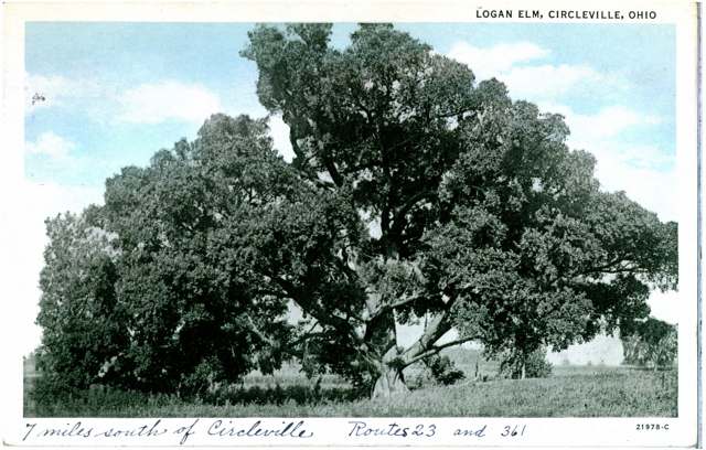
Photo: Columbus Metropolitan Library postcard collection, via DPLA/Wikimedia Commons, no known copyright restrictions · Wikimedia Commons
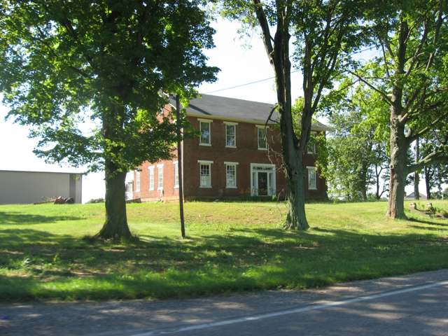
Photo: Nyttend, public domain · Wikimedia Commons
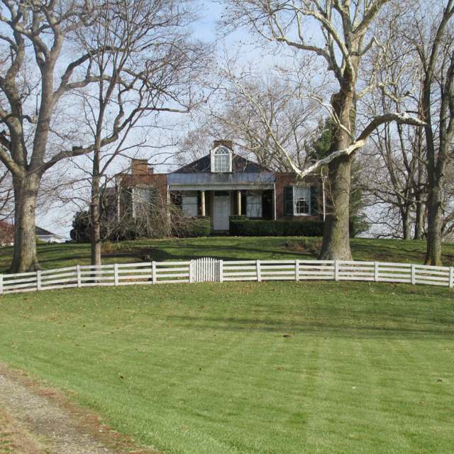
Photo: Aesopposea, via Wikimedia Commons, CC BY-SA 3.0 · Wikimedia Commons
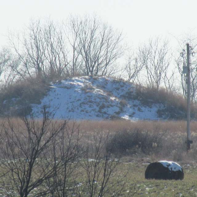
Photo: Aesopposea, via Wikimedia Commons, CC BY-SA 3.0 · Wikimedia Commons
Local history sources: archive.org · en.wikipedia.org · en.wikipedia.org · en.wikipedia.org · en.wikipedia.org · en.wikipedia.org · en.wikipedia.org · en.wikipedia.org · en.wikipedia.org · en.wikipedia.org · en.wikipedia.org · en.wikipedia.org · commons.wikimedia.org · commons.wikimedia.org · commons.wikimedia.org · commons.wikimedia.org
Historic places
3 places in Pickaway Township, Pickaway County on the National Register of Historic Places. Press a pin or a name for its whole record.
-
BellevueBuilding · Kingston · listed 1976
- Address
- N of Kingston on OH 159
- Where
- Kingston, Pickaway County · ZIP 45644
- What it is
- Building
- Listed on the National Register
- 1976
- NRIS reference number
- 76001508
- Coordinates
- 39.48364, -82.90189
National Register file (NPS) ↗ Search Wikipedia ↗ Street map and directions ↗ On the Cracked Buckeye map
-
Black, Joseph, FarmhouseBuilding · Circleville
- Address
- 9862 Heffner Rd.
- Where
- Circleville, Pickaway County · ZIP 43113
- What it is
- Building
- Latest NPS certification action
- 1982
- NRIS reference number
- 02001459
- Coordinates
- 39.51414, -82.84907
National Register file (NPS) ↗ Search Wikipedia ↗ Street map and directions ↗ On the Cracked Buckeye map
-
Mount OvalBuilding · Circleville · listed 1974
- Address
- Off U.S. 23
- Where
- Circleville, Pickaway County · ZIP 43113
- What it is
- Building
- Listed on the National Register
- 1974
- NRIS reference number
- 74001593
- Coordinates
- 39.52834, -82.96617
National Register file (NPS) ↗ Search Wikipedia ↗ Street map and directions ↗ On the Cracked Buckeye map
Source: National Park Service, National Register of Historic Places point file. The listing year is shown where NPS's certification date agrees with the listing's reference number. Listing recognizes significance; it does not restrict a private owner.
Water
Sand-and-gravel wells in the Scioto River valley aquifer at the city's Island Road well field/treatment plant site, just east of the river. The water here
- Circleville City74% of residentsScioto River valley aquifer (sand & gravel wells)
- Earnhart Hill Water District12% of residentsScioto River valley (Teays) aquifer wells
- Ross County Water Co. Inc8% of residentsTeays Valley Aquifer (buried valley groundwater)
- Kingston Village6% of residentsTeays Valley Aquifer (buried valley groundwater)
- South Bloomfield Village0% of residentsGroundwater wells (3 wells)
Hospitals, fire stations and more
Inside Pickaway Township, Pickaway County's boundary: 1 fire or EMS station, 2 public schools, 1 private school, 1 shale or injection well, 9 Toxics Release Inventory facilities, 14 spill cases and 1 mound or earthwork. Press a pin or a name for its whole record and its source.
Fire and EMS stations (1)
-
Pickaway Township Fire DepartmentCircleville
- Address
- 579 Tarlton Road, Circleville, OH 43113
- Coordinates
- 39.56633, -82.94484
USGS National Map structures (source) ↗ Street map and directions ↗
Source: USGS National Map structures (most Ohio records last updated 2019 to 2022), checked against the Columbus and Cleveland station lists. The department that answers a call is set by jurisdiction and mutual aid, not by distance.
Public schools (2)
-
Logan Elm Elementary School4.5 of 5 stars · Circleville
- Address
- 9511 Tarlton Rd, Circleville, OH 43113
- School district
- Logan Elm Local School District
- Kind (NCES)
- Regular School
- Students, 2023-24
- 839
- Teachers (full-time equivalent)
- 45
- Report card, 2025-26
- 4.5 of 5 stars
- Performance index
- 81.5%
- Ohio building IRN
- 064717
- NCES school ID
- 390490803483
NCES school record ↗ Ohio School Report Card ↗ Street map and directions ↗
-
Logan Elm Middle/High School3 of 5 stars · Circleville
- Address
- 9511 Tarlton Rd, Circleville, OH 43113
- School district
- Logan Elm Local School District
- Kind (NCES)
- Regular School
- Students, 2023-24
- 895
- Teachers (full-time equivalent)
- 56
- Report card, 2025-26
- 3 of 5 stars
- Performance index
- 74.2%
- Four-year graduation rate
- 96.6%
- Ohio building IRN
- 021212
- NCES school ID
- 390490803484
NCES school record ↗ Ohio School Report Card ↗ Street map and directions ↗
Source: NCES EDGE public school locations 2024-25 and Common Core of Data 2023-24 (type, students, teachers); Ohio School Report Cards 2025-26 (Department of Education and Workforce), matched by name within the district.
Private schools (1)
-
Crossroads Christian AcademyPrivate, religious, independent · Circleville
- Address
- 5679 Tarlton Rd, Circleville, OH 43113
- Kind
- religious, independent
- Students, 2023-24
- 80
- Teachers (full-time equivalent)
- 11
- Students per teacher
- 7.27273
- Phone
- (740) 207-0247
- NCES private school ID
- A1302298
Source: NCES Private School Survey 2023-24.
Shale and injection wells (1)
-
Bjm Company Inc (Swiw#6) 2 InjectionInjection well (Class II)
- What it is
- Injection well (Class II)
- Operator
- Northwood Energy Corp
- County
- Pickaway County
- API well number
- 34129200590000
- Coordinates
- 39.54944, -82.99273
ODNR oil and gas wells (source) ↗ Street map and directions ↗
Source: ODNR Division of Oil and Gas Resources well inventory (September 2026): drilled Utica, Marcellus and horizontal wells and Class II injection wells not plugged. Older vertical wells are on the full map.
Facilities reporting toxic releases (9)
-
Dupont Specialty Products - CirclevilleToxics Release Inventory · Circleville
- Address
- 800 Dupont Rd, Circleville, OH 43113
- County
- Pickaway County
- Status
- Reports to the Toxics Release Inventory (open)
- EPA program ID
- 43113DPNTCUSRT2
- EPA registry ID
- 110000381881
EPA facility record ↗ EPA Facility Registry Service (source) ↗ Street map and directions ↗
-
Dupont Specialty Products CirclevilleToxics Release Inventory · Circleville
- Address
- 810 Dupont Rd, Circleville, OH 43113
- County
- Pickaway County County
- Status
- Reports to the Toxics Release Inventory (***unchanged***)
- EPA program ID
- 4311WDPNTS81DUP
- EPA registry ID
- 110072136307
EPA facility record ↗ EPA Facility Registry Service (source) ↗ Street map and directions ↗
-
Dupont Specialty Products Usa LlcToxics Release Inventory · Circleville
- Address
- 810 Dupont Rd, Circleville, OH 43113
- County
- Pickaway County
- Status
- Reports to the Toxics Release Inventory (***unchanged***)
- EPA program ID
- 4311WDPNTS81DUB
- EPA registry ID
- 110072099339
EPA facility record ↗ EPA Facility Registry Service (source) ↗ Street map and directions ↗
-
Eg IndustriesToxics Release Inventory · Circleville
- Address
- 30627 Orr Road, Circleville, OH 43113
- Status
- Reports to the Toxics Release Inventory
- EPA program ID
- 4311WGNDST3627R
- EPA registry ID
- 110070332271
EPA facility record ↗ EPA Facility Registry Service (source) ↗ Street map and directions ↗
-
Florida Production Engineering - Circleville (0165010087)Toxics Release Inventory · Circleville
- Address
- 30627 Orr Road, Circleville, OH 43113
- County
- Pickaway County
- Status
- Reports to the Toxics Release Inventory (active)
- EPA program ID
- 43113WYNML30627
- EPA registry ID
- 110000493341
EPA facility record ↗ EPA Facility Registry Service (source) ↗ Street map and directions ↗
-
Georgia Pacific Corrugated LlcToxics Release Inventory · Circleville
- Address
- 2850 Owens Road, Circleville, OH 43113
- County
- Pickaway County
- Status
- Reports to the Toxics Release Inventory (active)
- EPA program ID
- 43113NKSPC2850O
- EPA registry ID
- 110009490504
EPA facility record ↗ EPA Facility Registry Service (source) ↗ Street map and directions ↗
-
Ppg IndustriesToxics Release Inventory · Circleville
- Address
- 559 Pittsburgh Rd, Circleville, OH 43113
- County
- Pickaway County
- Status
- Reports to the Toxics Release Inventory (active)
- EPA program ID
- 43113PPGNDPITTS
- EPA registry ID
- 110007158128
EPA facility record ↗ EPA Facility Registry Service (source) ↗ Street map and directions ↗
-
Sofidel AmericaToxics Release Inventory · Circleville
- Address
- 25910 Us 23, Circleville, OH 43113
- County
- Pickaway County County
- Status
- Reports to the Toxics Release Inventory (***unchanged***)
- EPA program ID
- 4311WSFDLM2591U
- EPA registry ID
- 110069996804
EPA facility record ↗ EPA Facility Registry Service (source) ↗ Street map and directions ↗
-
Trimold Llc (0165010125)Toxics Release Inventory · Circleville
- Address
- 200 Pittsburgh Rd, Circleville, OH 43113
- County
- Pickaway County
- Status
- Reports to the Toxics Release Inventory
- EPA program ID
- 4311WTRMLD2PITT
- EPA registry ID
- 110038044345
EPA facility record ↗ EPA Facility Registry Service (source) ↗ Street map and directions ↗
Source: EPA Facility Registry Service, Toxics Release Inventory reporters. Reporting a release is required of large users of listed chemicals; it is not by itself a violation.
Spills reported since 2021 (14)
-
Fuel Diesel / Diesel Fuel (Vehicle On Or Off Road)2025-05-06 · Pickaway Twp
- Reported
- 2025-05-06
- What spilled
- Fuel Diesel / Diesel Fuel (Vehicle On Or Off Road)
- Largest amount reported
- 100 gallons
- Where
- Pickaway Twp, Pickaway County
- Ohio EPA district office
- CDO
- Ohio EPA case number
- 2505EPA0000714
Ohio EPA spill reports (source) ↗ Street map and directions ↗
-
Food Grade Product Solid2025-04-24 · Pickaway Twp
- Reported
- 2025-04-24
- What spilled
- Food Grade Product Solid
- Where
- Pickaway Twp, Pickaway County
- Ohio EPA district office
- CDO
- Ohio EPA case number
- 2504EPA0000636
Ohio EPA spill reports (source) ↗ Street map and directions ↗
-
Fuel Diesel / Diesel Fuel (Vehicle On Or Off Road)2025-03-11 · Pickaway Twp
- Reported
- 2025-03-11
- What spilled
- Fuel Diesel / Diesel Fuel (Vehicle On Or Off Road)
- Largest amount reported
- 50 gallons
- Where
- Pickaway Twp, Pickaway County
- Ohio EPA district office
- CDO
- Ohio EPA case number
- 2503EPA0000333
Ohio EPA spill reports (source) ↗ Street map and directions ↗
-
Oil Petroleum Not Otherwise Specified (Nos)2024-11-15 · Pickaway Twp
- Reported
- 2024-11-15
- What spilled
- Oil Petroleum Not Otherwise Specified (Nos)
- Where
- Pickaway Twp, Pickaway County
- Ohio EPA district office
- CDO
- Ohio EPA case number
- 2411EPA0001886
Ohio EPA spill reports (source) ↗ Street map and directions ↗
-
Oil Transformer Non Pcb2024-09-28 · Pickaway Twp
- Reported
- 2024-09-28
- What spilled
- Oil Transformer Non Pcb
- Where
- Pickaway Twp, Pickaway County
- Ohio EPA district office
- CDO
- Ohio EPA case number
- 2409EPA0001667
Ohio EPA spill reports (source) ↗ Street map and directions ↗
-
Material Unknown2024-08-29 · Pickaway Twp
- Reported
- 2024-08-29
- What spilled
- Material Unknown
- Where
- Pickaway Twp, Pickaway County
- Ohio EPA district office
- CDO
- Ohio EPA case number
- 2408EPA0001487
Ohio EPA spill reports (source) ↗ Street map and directions ↗
-
Fuel Diesel / Diesel Fuel (Vehicle On Or Off Road)2024-07-13 · Pickaway Twp
- Reported
- 2024-07-13
- What spilled
- Fuel Diesel / Diesel Fuel (Vehicle On Or Off Road)
- Largest amount reported
- 50 gallons
- Where
- Pickaway Twp, Pickaway County
- Ohio EPA district office
- CDO
- Ohio EPA case number
- 2407EPA0001185
Ohio EPA spill reports (source) ↗ Street map and directions ↗
-
Fuel Diesel / Diesel Fuel (Vehicle On Or Off Road)2024-05-06 · Pickaway Twp
- Reported
- 2024-05-06
- What spilled
- Fuel Diesel / Diesel Fuel (Vehicle On Or Off Road)
- Largest amount reported
- 100 gallons
- Where
- Pickaway Twp, Pickaway County
- Ohio EPA district office
- CDO
- Ohio EPA case number
- 2405EPA0000755
Ohio EPA spill reports (source) ↗ Street map and directions ↗
-
Sodium Hypochlorite (Naclo)2023-09-09 · Pickaway Twp
- Reported
- 2023-09-09
- What spilled
- Sodium Hypochlorite (Naclo)
- Largest amount reported
- 75 gallons
- Where
- Pickaway Twp, Pickaway County
- Ohio EPA district office
- CDO
- Ohio EPA case number
- 2309EPA0001580
Ohio EPA spill reports (source) ↗ Street map and directions ↗
-
Fuel Diesel / Diesel Fuel (Vehicle On Or Off Road)2022-03-24 · Pickaway Twp
- Reported
- 2022-03-24
- What spilled
- Fuel Diesel / Diesel Fuel (Vehicle On Or Off Road)
- Largest amount reported
- 25 gallons
- Where
- Pickaway Twp, Pickaway County
- Ohio EPA district office
- CDO
- Ohio EPA case number
- 2203EPA0000405
Ohio EPA spill reports (source) ↗ Street map and directions ↗
-
Fuel Diesel / Diesel Fuel (Vehicle On Or Off Road)2021-01-06 · Pickaway Twp
- Reported
- 2021-01-06
- What spilled
- Fuel Diesel / Diesel Fuel (Vehicle On Or Off Road)
- Largest amount reported
- 125 gallons
- Where
- Pickaway Twp, Pickaway County
- Ohio EPA district office
- CDO
- Ohio EPA case number
- 2101EPA0000018
Ohio EPA spill reports (source) ↗ Street map and directions ↗
-
Oil Hydraulic Fluid(S)2026-05-08 · Pickaway Twp
- Reported
- 2026-05-08
- What spilled
- Oil Hydraulic Fluid(S)
- Largest amount reported
- 1 gallons
- Where
- Pickaway Twp, Pickaway County
- Ohio EPA district office
- CDO
- Ohio EPA case number
- 2605EPA0000772
Ohio EPA spill reports (source) ↗ Street map and directions ↗
-
Fuel Diesel / Diesel Fuel (Vehicle On Or Off Road)2026-03-09 · Pickaway Twp
- Reported
- 2026-03-09
- What spilled
- Fuel Diesel / Diesel Fuel (Vehicle On Or Off Road)
- Largest amount reported
- 300 gallons
- Where
- Pickaway Twp, Pickaway County
- Ohio EPA district office
- CDO
- Ohio EPA case number
- 2603EPA0000339
Ohio EPA spill reports (source) ↗ Street map and directions ↗
-
Fuel Diesel / Diesel Fuel (Vehicle On Or Off Road)2026-01-09 · Pickaway Twp
- Reported
- 2026-01-09
- What spilled
- Fuel Diesel / Diesel Fuel (Vehicle On Or Off Road)
- Largest amount reported
- 37 gallons
- Where
- Pickaway Twp, Pickaway County
- Ohio EPA district office
- CDO
- Ohio EPA case number
- 2601EPA0000022
Ohio EPA spill reports (source) ↗ Street map and directions ↗
Source: Ohio EPA emergency response spill reports, 2021 to September 2026, one point per case where Ohio EPA placed it. A report is what the caller or responder recorded; amounts are often blank or estimated.
Mounds and earthworks (1)
-
Arledge Mounds I and IIMound · Adena
- What it is
- Mound
- Also named
- Arledge Mounds I and II (Adams Archeological Preserve)
- Age
- Adena
- Where
- off State Route 56, southeast of Circleville, Pickaway Township
- County
- Pickaway County
- Named in the history of
- Pickaway Township, Pickaway County
- Map point
- from the site's Wikipedia article
Wikipedia article (point and source) ↗ Street map and directions ↗
Many mounds stand on private land; visit only those open to the public.
Source: the History records' native sites, each placed by its own Wikipedia article; sites no article places are named on the History card but not pinned.
Its ZIP codes
Each ZIP code that touches Pickaway Township, Pickaway County, with the share of its residents who live here and the same headline figures as the ZIP page.
| ZIP | Share | Water | Radon | Home value | Schools | Flood |
|---|---|---|---|---|---|---|
| 43113 Circleville | 7% | Sand-and-gravel wells in the Scioto River valley aquifer at the city's Island Road well field/treatment plant site, just east of the river. | 8.0 pCi/L average radon | Median year built 1967 | Circleville City · 3 stars overall | 7.0% of residents in the 1% floodplain |
| 45644 Kingston | 5% | Eight wells in the buried Teays River Aquifer, in the Scioto valley north of Chillicothe | 3.6 pCi/L average radon | Median year built 1980 | Zane Trace Local · 3 stars overall | 0.2% of residents in the 1% floodplain |
Local government
Who holds office in Pickaway Township, Pickaway County, how its elections and ballot issues came out, and the state auditor's record.
Money issues on the ballot since 2021: 2 of 2 passed; of those asking for new or higher taxes, 1 of 1.
Ballot issues
| Date | Issue | For | Against | Result |
|---|---|---|---|---|
| 2024-11-05 | Issue: Pickaway Township Additional, 4 mills Fire & EMS Tax Levy (4.0 mills, additional) | 713 | 590 | Passed (54.72% for) |
| 2021-11-02 | Issue: Proposed Tax Levy (Renewal), Expenses, 0.75 mill Pickaway Senior Center (0.75 mills, renewal) | 7,961 | 3,370 | Passed (70.26% for) |
Elections for office
| Date | Office | Candidates and votes |
|---|---|---|
| 2017-11-07 | Township Trustee | Mark E. Martin 363, 55.67%; Jamie Twining 289, 44.33% |
Winners in bold. Results from the county board of elections' official canvass unless marked.
Auditor of State record
- No fiscal caution, watch or emergency on the Auditor of State's lists.
- Financial Audit, 2022 to 2023, released 2025-02-20
The county
Pickaway County: 8 ZIP codes, 22 cities, villages and townships, 56,176 people.
Nearby places
Quick answers
What county is Pickaway Township, Ohio in?
Pickaway Township, Pickaway County is a township in Pickaway County, Ohio, with 2,036 residents.
When was Pickaway Township, Ohio founded?
Pickaway Township, Pickaway County was settled 1796 or 1797 (Caleb Evans, on Scippo Creek on the Pickaway Plains); incorporated before Pickaway County was erected in 1810; no exact organization date survives. Source
How did Pickaway Township, Ohio get its name?
The township's name, like the county's and the Pickaway Plains themselves, derives from the Pekowi (also rendered Piqua) band of the Shawnee, who inhabited the area in the eighteenth century. Source
What ZIP code is Pickaway Township, Ohio?
Pickaway Township, Pickaway County is served by ZIP codes 43113 and 45644; 43113 holds the largest share of its residents.
Where does Pickaway Township, Ohio get its water?
The main water source for Pickaway Township, Pickaway County (Circleville City): Sand-and-gravel wells in the Scioto River valley aquifer at the city's Island Road well field/treatment plant site, just east of the river.
Cite this page
Cite this page as:
Cracked Buckeye, "Pickaway Township, Pickaway County", https://crackedbuckeye.com/place/pickaway-township-pickaway-county/, built 2026-10-31, accessed [date].
How to cite · Report a correction · Built 2026-10-31
