How Marble Cliff began
Marble Cliff grew from farmland that surveyor Lucas Sullivant divided and sold to pioneer families in 1842, into a planned community that developers John E. Price and Charles Griswold began building on the ridge above the Scioto River around 1890, first under the name Arlington Place. It incorporated as the Hamlet of Marble Cliff on October 12, 1901, taking its lasting name from the nearby Marble Cliff Quarry Co. rather than Arlington, and quickly split apart: a governance dispute between its northern and southern halves sent the south into its own Village of Grandview Heights by 1906, while the remaining hamlet reincorporated as the separate Village of Marble Cliff in 1908. The two villages have stayed independent ever since, though Marble Cliff, one of the smallest municipalities in the Columbus area at 634 residents in 2020, still contracts police and other public services through its onetime other half.
Settled 1890, incorporated 1901-10-12, by Developers John E. Price and Charles Griswold, building on farmland pioneering families (the Slyhs, Millers, and Woods) had worked since Lucas Sullivant divided and sold the surrounding land in 1842; incorporated as the Hamlet of Marble Cliff on October 12, 1901, and reincorporated in its present, smaller form as a village in 1908.
Where the name comes from
The planned community was first called "Arlington" or "Arlington Place." When it incorporated in 1901, it took the name Marble Cliff instead, after the Marble Cliff Quarry Co., whose limestone quarries, railroad station, and post office near Fifth Avenue already carried that name. Marble Cliff's abandoned "Arlington" name did not go to waste: it was picked up in 1918 by the newly incorporated village of Upper Arlington a few miles northwest.
Before the town
The clearest documented Native American presence in the immediate area comes from the account of surveyor Lucas Sullivant, who explored the Scioto and Olentangy river valleys in 1796 by following existing Indian paths before claiming land and laying out Franklinton. No source found for this entry names the specific nation or trail involved, or records a village, mound, or other site within what became Marble Cliff itself. The land lies within the area the Treaty of Greenville (August 3, 1795) ceded to the United States the year before Sullivant's survey. Broader Native history for the county is covered in the Franklin County file.
Nations recorded here: Wyandot, Shawnee, Mingo (Seneca-Cayuga).
- Indian paths along the Scioto and Olentangy rivers (trail) — Scioto and Olentangy river valleys, near present Marble Cliff and Grandview Heights, prior to 1796 (ghmchs.org)
Timeline
- — Surveyor Lucas Sullivant explores the Scioto and Olentangy valleys, following existing Indian paths, and begins claiming land tracts in the area.
- — Sullivant divides the land that becomes Grandview Heights and Marble Cliff into twelve plots and sells them to pioneer families, including the O'Harras, Sperrys, and Walcutts.
- — A Bucher Engraving Co. photograph of a prominent home in the area is published in "Handsome Homes of Columbus, Ohio," a turn-of-the-century book of the city's notable residences.
- — Developers John E. Price and Charles Griswold begin building a planned community, first called Arlington Place, on the ridge overlooking the Scioto River where the Slyh, Miller, and Wood families had farmed.
- — The community incorporates on October 12 as the Hamlet of Marble Cliff, named for the nearby quarries rather than Arlington, stretching from the Scioto River to the Olentangy River.
- — A dispute between the hamlet's northern and southern residents over development costs leads the south to detach in January 1903 under a new state law, withdrawing as Arlington, Grandview, and Chester Heights.
- — After Columbus refuses the detached area's request for water and electric service, about 200 residents vote to incorporate as the Village of Grandview Heights, with S. C. Jones as president and C. F. Butterworth as clerk.
- — The remaining hamlet reincorporates as the separate Village of Marble Cliff, in essentially its present, much smaller boundary.
- — Upper Arlington incorporates a few miles to the northwest, adopting the Arlington name Marble Cliff had given up in 1901.
- — Marble Cliff declines an offer to reunite with Grandview Heights, choosing to remain a separate village.
- — The census records 634 residents, making Marble Cliff one of the smallest incorporated municipalities in the Columbus area; it continues to contract police and other public services through Grandview Heights.
Stories
From Arlington to Marble Cliff
When developers John E. Price and Charles Griswold began platting a planned community on the ridge above the Scioto River around 1890, on land the Slyh, Miller, and Wood families had farmed since Lucas Sullivant sold it off in 1842, they called it Arlington Place. By the time residents incorporated in 1901, though, the name that stuck was Marble Cliff, for the limestone quarry company whose works, railroad station, and post office near Fifth Avenue already carried that name across the area. The abandoned Arlington name did not disappear for long: in 1918, a new village a few miles to the northwest incorporated as Upper Arlington, picking up the name Marble Cliff no longer needed.
A village splits in two
The Hamlet of Marble Cliff that incorporated in October 1901 was a much bigger place than the village of the same name today, stretching all the way from the Scioto River to the Olentangy and north to what is now King Avenue. Almost immediately, its northern and southern residents began fighting over development plans and who should pay for them; local lore remembers Mayor J. S. Ricketts for fining revelers at the local country club during the dispute. Under a new state law, southern residents detached in January 1903 and briefly went by the names Arlington, Grandview, and Chester Heights before Columbus refused to extend water and electric service to the breakaway area, pushing about 200 of them to organize their own government. They incorporated as the Village of Grandview Heights in 1906, and the remaining northern hamlet reincorporated on its own, smaller footprint as the Village of Marble Cliff in 1908. When Grandview Heights offered to reunite the two villages in 1925, Marble Cliff said no, and the two have stayed separate, if closely linked, ever since.
The quarry that built the village
The Marble Cliff Quarry Co. worked outcrops of Columbus Limestone, a fossil-rich Devonian-era rock formed roughly 380 million years ago from an ancient sea floor, along the west bank of the Scioto River. The stone was good enough, and close enough to the growing city, to give its name to a rail station, a post office, and eventually the whole community that grew up around it, and quarrying continued in the area for generations; the former Marblecliff Quarry pit near the river is now part of Quarry Trails Park. Fossil hunters still visit outcrops near the old quarry today to find corals and coiled cephalopods preserved in the same limestone that once went into Columbus's buildings and roads.
Photographs
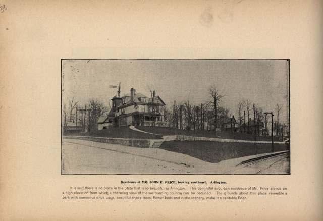
Photo: Bucher Engraving Co.; Columbus Metropolitan Library, via Digital Public Library of America, public domain · Wikimedia Commons
Photo: Photograph by Derek Jensen (Tysto), public domain · Wikimedia Commons
Photo: Photograph by Columbusite, CC BY 3.0 · Wikimedia Commons
Photo: Photograph by Pythaglio (Christopher Riley), CC BY-SA 2.0 · Wikimedia Commons
Local history sources: en.wikipedia.org · marblecliff.org · ghmchs.org · en.wikipedia.org · en.wikipedia.org · commons.wikimedia.org · commons.wikimedia.org · commons.wikimedia.org · commons.wikimedia.org
Water
Scioto River intake at the plant on Dublin Rd, a few miles below Griggs Dam, opposite Marble Cliff The water here
- Columbus Public Water System100% of residentsScioto River (Griggs & O'Shaughnessy), Hoover Reservoir on Big Walnut Ck, plus wells
Its ZIP codes
Each ZIP code that touches Marble Cliff, with the share of its residents who live here and the same headline figures as the ZIP page.
| ZIP | Share | Water | Radon | Home value | Schools | Flood |
|---|---|---|---|---|---|---|
| 43212 Columbus | 3% | Scioto River intake at the plant on Dublin Rd, a few miles below Griggs Dam, opposite Marble Cliff | 4.8 pCi/L average radon | Median year built 1942 | Columbus City · 2 stars overall | 0.0% of residents in the 1% floodplain |
The county
Franklin County: 45 ZIP codes, 42 cities, villages and townships, 1,356,733 people.
Nearby places
Cite this page
Cite this page as:
Cracked Buckeye (Open Shower Co), "Marble Cliff, Franklin County", https://crackedbuckeye.com/place/marble-cliff/, built 2026-09-16, accessed [date].
Machine-readable: /api/place/marble-cliff.json (open JSON, CC BY 4.0 for the compilation; the underlying records keep their own terms) · How to cite · Report a correction · Built 2026-09-16