How Clinton Township, Franklin County began
Clinton Township was organized by the Franklin County commissioners on July 1, 1811, out of land surveyed in 1797 as part of Lucas Sullivant's Virginia Military District work, and named for Vice President George Clinton. It grew as a farming township along the Olentangy River, gave its name to the Clintonville neighborhood that grew up around a post office opened in 1847, and hosted the winter quarters of the Sells Brothers circus at Sellsville after 1871. Columbus annexed most of the township's land between the 1950s and early 1970s, including the future Ohio State University campus area, leaving Clinton Township today as a set of small unincorporated islands surrounded by the city.
Settled by 1811 (first residents named in township records include the Fulton, Hunter, Elvaire, Lisle, Henderson, Hess and Beer families; Roswell Wilcox arrived in 1814 and built mills on the Olentangy), incorporated 1811-07-01, by Franklin County commissioners; the township's four boundary lines had been surveyed in 1797.
Where the name comes from
The township was named for George Clinton, who was serving as Vice President of the United States when Clinton Township was organized in 1811.
Before the town
No mounds, earthworks, villages or trails specific to Clinton Township turned up in the sources checked. The Wikipedia article for Clintonville, the neighborhood that grew up as the township's center, states in passing that the land here 'used to be Wyandot Indian territory' and was later surveyed as part of the U.S. military land-grant system, but names no specific village, camp or path. County-wide Native American context (the prehistoric mound-building cultures, the historic nations, and the treaties that opened this part of Ohio to survey and settlement) belongs in the Franklin County file rather than here.
Nations recorded here: Wyandot.
Timeline
- — Lucas Sullivant surveys the Virginia Military District lands at the forks of the Scioto and Olentangy rivers, the same survey work that later fixed Clinton Township's boundaries.
- — The four boundary lines of what becomes Clinton Township are run by government surveyors, the same year Sullivant plats Franklinton a few miles south.
- — Franklin County commissioners organize Clinton Township, at first including the land that becomes Mifflin Township.
- — Mifflin Township is set off from Clinton Township's western portion, fixing Clinton Township's present boundary.
- — Thomas Bull, a Methodist minister from Vermont, buys 600 acres from John Rathbone along the Columbus-Worthington Pike, the purchase that seeds the later community of Clintonville.
- — Roswell Wilcox settles in the township and builds mills along the Olentangy River.
- — Clinton Township's population is recorded at 969.
- — A post office named Clintonville opens at the center of the township along North High Street, giving the future neighborhood its name.
- — Brothers Ephraim, Allen (William), Lewis and Peter Sells launch the Sells Brothers circus out of Columbus and establish winter quarters at Sellsville, in Clinton Township along the Olentangy River near King Avenue.
- — Clinton Township's population reaches 4,750; the same year, the Sells Brothers circus merges with Adam Forepaugh's show to form the Forepaugh-Sells Brothers' Circus.
- — Clintonville develops as a streetcar suburb as trolley lines are extended north from Columbus along High Street.
- — The City of Columbus annexes most of Clinton Township, including the area that became the Ohio State University campus, leaving the township as scattered unincorporated islands.
- — Clinton Township's remaining unincorporated area, now 1.4 square miles in scattered parcels, records a population of about 4,499 to 4,750 depending on the count.
Stories
Splitting Clinton from Mifflin
When Franklin County's commissioners organized Clinton Township on July 1, 1811, they drew it much larger than it is known today, folding in land to the west that residents soon wanted managed separately. Two months later, on September 2, 1811, the commissioners set off that western portion as Mifflin Township, leaving Clinton with the boundaries it substantially kept for the next 140 years. The lines themselves were older than the township: government surveyors had run Clinton's four sides back in 1797, the same year Lucas Sullivant was laying out Franklinton a few miles south at the forks of the Scioto and Olentangy. For over a century afterward, Clinton Township was farmland and small mills along the Olentangy, its population climbing slowly from 969 in 1840 to 4,750 by 1900.
The Sells Brothers and Sellsville
In 1871, four brothers from a Columbus livestock-trading family, Ephraim, Allen, Lewis and Peter Sells, put together a circus. Within a decade it was one of the largest touring shows in the country, competing with Barnum's. Its winter quarters, known as Sellsville, sat in Clinton Township along the Olentangy River near what is now King Avenue, where animals, performers and equipment stayed through the off-season in a small company town built around the show. The circus toured under the Sells Brothers name through 1895, printing elaborate seasonal route booklets, before merging in 1900 with Adam Forepaugh's rival circus to form the Forepaugh-Sells Brothers' Circus, and later still combining with the Floto Dog and Pony Show as the Sells-Floto Circus. A 1901 Edison Manufacturing Company film captured a parade and horse race from the show, among the earliest motion-picture footage of a circus.
A crossroads becomes Clintonville
Clinton Township's most enduring settlement began in 1813, when Thomas Bull, a Methodist minister newly arrived from Vermont, paid John Rathbone for 600 acres along the Columbus-Worthington Pike, today's North High Street. Bull and his family worked to draw tradesmen and skilled laborers to the crossroads, and the settlement grew slowly around them for a generation. It did not have a name of its own until September 13, 1847, when a post office called Clintonville opened at the center of the district, borrowing the township's name for the community that treats that date as its birthday. Clintonville stayed a loose farming crossroads until streetcar lines were pushed north from Columbus in the early twentieth century, after which it filled in as one of the city's classic streetcar suburbs, even as it remained, technically, part of Clinton Township until annexation caught up with it.
From farm township to city islands
For most of the nineteenth century Clinton Township was unremarkable Franklin County farmland, its boundaries essentially unchanged since the 1811 split from Mifflin Township. That began to change as Columbus grew north along High Street, and it accelerated sharply in the mid-twentieth century: between the 1950s and the early 1970s the city annexed the great majority of the township's land, parcel by parcel, including the ground that had become Ohio State University's campus. What is left of Clinton Township today is not a single contiguous place but a scatter of small unincorporated 'islands,' about 1.4 square miles in total, surrounded on every side by the city that grew up around them, still governed as a township even though most residents would say they live in Columbus.
Photographs
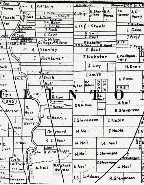
Photo: Columbus Metropolitan Library, via Digital Public Library of America / Ohio Digital Network, no known copyright restrictions · Wikimedia Commons
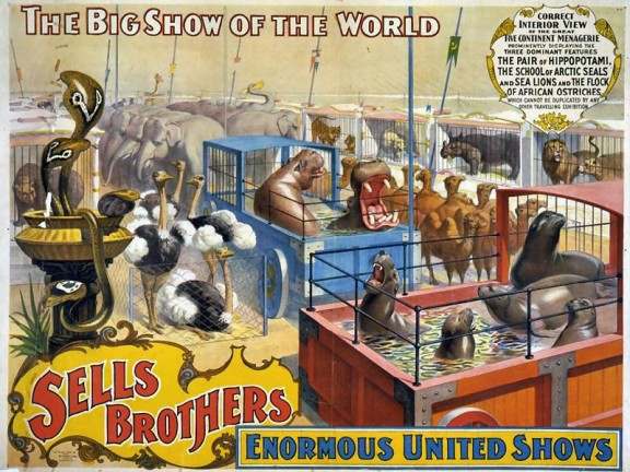
Photo: Unknown publisher; Wikimedia Commons, public domain · Wikimedia Commons
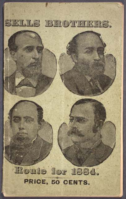
Photo: Illinois State University Digital Collection, via Wikimedia Commons, public domain · Wikimedia Commons
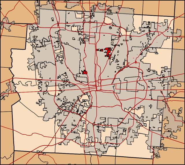
Photo: Ibagli, via Wikimedia Commons, CC0 · Wikimedia Commons
Local history sources: en.wikipedia.org · clintontownship.org · en.wikipedia.org · en.wikipedia.org · en.wikipedia.org · en.wikipedia.org · en.wikipedia.org · commons.wikimedia.org · commons.wikimedia.org · commons.wikimedia.org · commons.wikimedia.org
Water
Big Walnut Creek at the plant's low-head dam and screen house on Morse Rd, below Hoover Dam The water here
- Columbus Public Water System100% of residentsScioto River (Griggs & O'Shaughnessy), Hoover Reservoir on Big Walnut Ck, plus wells
Its ZIP codes
Each ZIP code that touches Clinton Township, Franklin County, with the share of its residents who live here and the same headline figures as the ZIP page.
| ZIP | Share | Water | Radon | Home value | Schools | Flood |
|---|---|---|---|---|---|---|
| 43224 Columbus | 8% | Big Walnut Creek at the plant's low-head dam and screen house on Morse Rd, below Hoover Dam | 4.5 pCi/L average radon | Median year built 1956 | Columbus City · 2 stars overall | 0.0% of residents in the 1% floodplain |
| 43212 Columbus | 3% | Scioto River intake at the plant on Dublin Rd, a few miles below Griggs Dam, opposite Marble Cliff | 4.8 pCi/L average radon | Median year built 1942 | Columbus City · 2 stars overall | 0.0% of residents in the 1% floodplain |
The county
Franklin County: 45 ZIP codes, 42 cities, villages and townships, 1,356,733 people.
Nearby places
Cite this page
Cite this page as:
Cracked Buckeye (Open Shower Co), "Clinton Township, Franklin County", https://crackedbuckeye.com/place/clinton-township-franklin-county/, built 2026-09-16, accessed [date].
Machine-readable: /api/place/clinton-township-franklin-county.json (open JSON, CC BY 4.0 for the compilation; the underlying records keep their own terms) · How to cite · Report a correction · Built 2026-09-16