Local events in Stonelick Township, Clermont County
Nothing is posted for Stonelick Township itself yet; here is what is on within 10 miles. All local events in Stonelick Township, Clermont County
Know a calendar we should watch? Send the link
Checked October 20; the events page is refreshed daily.
How Stonelick Township, Clermont County began
Stonelick Township, north of the county's center, saw one of Clermont County's earliest attempted settlements in 1792, when settlers deadened a few acres and built a pole cabin about a mile above the mouth of Stonelick Creek -- only to abandon it because of the ongoing hostility of the Indian war then raging across the Ohio country. The site sat empty for six years until Henry Allison, brother of physician and Revolutionary War veteran Dr. Richard Allison, returned in 1798 to clear the same ground and build the township's first permanent home. That same spring of 1792, a survey party under Gen. Nathaniel Massie was attacked while breaking camp elsewhere in the township and fell back to a fortified station. The township holds the Stonelick Covered Bridge, a National Register-listed 1878 span east of Perintown, and Stonelick State Park.
Settled 1798, by Henry Allison, first permanent settler (1798), on the site of an abandoned 1792 settlement attempt.
Where the name comes from
The township is named for Stonelick Creek, which drains it; no source consulted here explains the origin of the creek's own name, though "lick" place-names in Ohio commonly mark a mineral or salt lick once frequented by game and, before that, by Native hunters.
Before the town
The clearest Native-related record specific to Stonelick Township is negative but telling: the 1880 county history records that settlers first attempted to occupy the township in 1792, deadening four or five acres and building a pole cabin about a mile above the mouth of Stonelick Creek, but abandoned the site soon after "owing to the hostility of the Indians" then resisting American settlement across the region -- a direct, if brief, acknowledgment that armed Native resistance actively blocked settlement here for six years, until Henry Allison's permanent 1798 return. In the same spring of 1792, a nine-man survey party under Gen. Nathaniel Massie was attacked by about twenty-two Indians while preparing breakfast somewhere in the township; Massie's men fell back, after a brief exchange of fire, to Gerard's Station, then commanded by Capt. Richard Hall, with one man slightly wounded. The 1880 county history also records a prehistoric earthwork here: an eight-acre circular enclosure on the Cincinnati turnpike, bordering Stonelick Creek, on the farm of K. C. (or E. C.) Patchell, with walls three to five feet high and a low mound of broken limestone, red sand and clay nearby. No source ties this enclosure to a named historic nation. The wider Native history of the surrounding area includes the 1792 Battle of Grassy Run in neighboring Jackson Township.
Nations recorded here: Shawnee.
- Patchell enclosure (earthwork) — Stonelick Township, on the Cincinnati turnpike bordering Stonelick Creek, on K. C. Patchell's farm, prehistoric, Mound-Builder (archive.org)
Timeline
- — Spring: an early attempt at settlement in Stonelick Township, a mile above the mouth of Stonelick Creek, is abandoned because of Indian hostility, after four or five acres are cleared and a pole cabin built.
- — The same spring, Gen. Nathaniel Massie's nine-man survey party, breakfasting in Stonelick Township, is attacked by about twenty-two Indians and retreats to Gerard's Station, commanded by Capt. Richard Hall; one man is slightly wounded and three of the attackers are seen to fall.
- — Henry Allison, brother of Revolutionary War veteran and physician Dr. Richard Allison, returns to the abandoned 1792 clearing and builds the township's first permanent cabin.
- — Dr. Richard Allison, holder of a 441-acre Revolutionary War land patent, builds a two-story double log cabin on the road from Stonelick to East Liberty; the house stands until 1862, when it is torn down by E. C. Patchell.
- — The Stonelick Covered Bridge, a 140-foot, one-lane, 12-panel Howe truss span, is built east of Perintown over Stonelick Creek; it becomes the last surviving covered bridge in Clermont County.
- — September 10: the Stonelick Covered Bridge is added to the National Register of Historic Places.
- — February 11: during a planned restoration, the upper shell of the Stonelick Covered Bridge unexpectedly collapses; all workers escape safely, and the bridge is fully disassembled and rebuilt, reopening February 1, 2015.
Stories
Twice settled
The first documented attempt to settle Stonelick Township came in 1792, at the height of the fighting between American settlers and the Northwestern Indian confederacy, when an unnamed party cleared four or five acres about a mile above the mouth of Stonelick Creek and put up a pole cabin. It did not last: the 1880 county historian records only that the place was abandoned soon after "owing to the hostility of the Indians," a spare phrase that stands in for whatever specific danger or violence drove the settlers out. The clearing then sat empty and reverting to brush for six years, through the rest of the war and the 1795 Treaty of Greenville that ended it, until Henry Allison arrived in 1798 to reclaim the same ground his predecessors had given up. Allison cleared what remained of the old deadening and built a cabin on the identical site, making him the township's first permanent settler on land that had already, in a sense, been settled and lost once before.
Photographs
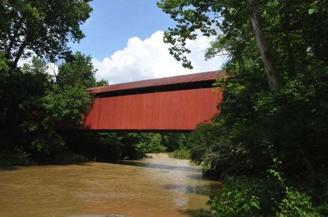
Photo: Jerrye and Roy Klotz, MD, CC BY-SA 4.0 · Wikimedia Commons
Local history sources: archive.org · en.wikipedia.org · en.wikipedia.org · commons.wikimedia.org
Historic places
1 place in Stonelick Township, Clermont County on the National Register of Historic Places. Press a pin or a name for its whole record.
-
Stonelick Covered BridgeStructure · Perintown · listed 1974
- Address
- E of Perintown
- Where
- Perintown, Clermont County · ZIP 45103
- What it is
- Structure
- Listed on the National Register
- 1974
- NRIS reference number
- 74001419
- Coordinates
- 39.13130, -84.18715
National Register file (NPS) ↗ Search Wikipedia ↗ Street map and directions ↗ On the Cracked Buckeye map
Source: National Park Service, National Register of Historic Places point file. The listing year is shown where NPS's certification date agrees with the listing's reference number. Listing recognizes significance; it does not restrict a private owner.
Water
Five wells in the sand-and-gravel aquifer of the Little Miami River valley at Miamiville, Miami Township The water here
- Clermont Public Water System88% of residentsWilliam H. Harsha Lake plus wells in the Little Miami River and Ohio River aquifers
- Western Water Company7% of residentsLittle Miami River valley wells (51%) plus Cincinnati Ohio River water (49%)
- Milford City2% of residentsGroundwater wells (4 wells)
- Williamsburg Village2% of residentsWilliam H. Harsha Lake plus wells in the Little Miami River and Ohio River aquifers
- Tate-monroe Water Association1% of residentsOhio River valley aquifer (collector/vertical wells)
- Indian Hill City0% of residentsLittle Miami River valley aquifer (wells near Milford)
Hospitals, fire stations and more
Inside Stonelick Township, Clermont County's boundary: 2 fire and EMS stations, 1 high-hazard dam, 3 public schools, 3 poor-rated bridges, 1 library, 1 museum and 7 spill cases. Press a pin or a name for its whole record and its source.
Fire and EMS stations (2)
-
Stonelick Township Fire and Rescue Station 2Batavia
- Address
- 5750 Stonelick Williams Corner Road, Batavia, OH 45103
- Coordinates
- 39.16561, -84.16202
USGS National Map structures (source) ↗ Street map and directions ↗
-
Stonelick Township Fire DepartmentBatavia
- Address
- 2541 US Highway 50, Batavia, OH 45103
- Coordinates
- 39.12306, -84.12352
USGS National Map structures (source) ↗ Street map and directions ↗
Source: USGS National Map structures (most Ohio records last updated 2019 to 2022), checked against the Columbus and Cleveland station lists. The department that answers a call is set by jurisdiction and mutual aid, not by distance.
High-hazard dams (1)
-
Galley Hill Lake Dam PoorTributary To Stonelick Creek · condition: poor
- Hazard class
- High: a failure would probably cost a life
- Condition
- Poor (assessed 08/30/2024)
- River or stream
- Tributary To Stonelick Creek
- Purpose
- Recreation
- Type
- Earth
- Height
- 63 ft
- Storage
- 77 acre-feet
- Completed
- 1960
- Owner type
- Private
- County
- Clermont County
- Nearest town (NID)
- Stonelick
- Last inspection
- 05/14/2024
- Emergency action plan
- Yes
- NID ID
- OH01358
National Inventory of Dams record ↗ National Inventory of Dams (source) ↗ Street map and directions ↗
Source: U.S. Army Corps of Engineers National Inventory of Dams, August 2026. "High hazard" rates what a failure would cost downstream, not how likely one is; the condition is the state's assessment.
Public schools (3)
-
Clermont Northeastern Elementary School3.5 of 5 stars · Batavia
- Address
- 5347 Hutchinson Rd, Batavia, OH 45103
- School district
- Clermont-Northeastern Local School District
- Kind (NCES)
- Regular School
- Students, 2023-24
- 553
- Teachers (full-time equivalent)
- 32.54
- Report card, 2025-26
- 3.5 of 5 stars
- Performance index
- 77.4%
- Ohio building IRN
- 028985
- NCES school ID
- 390463202512
NCES school record ↗ Ohio School Report Card ↗ Street map and directions ↗
-
Clermont Northeastern High School3 of 5 stars · Batavia
- Address
- 5327 Hutchinson Rd, Batavia, OH 45103
- School district
- Clermont-Northeastern Local School District
- Kind (NCES)
- Regular School
- Students, 2023-24
- 414
- Teachers (full-time equivalent)
- 24.24
- Report card, 2025-26
- 3 of 5 stars
- Performance index
- 72.1%
- Four-year graduation rate
- 98.2%
- Ohio building IRN
- 006635
- NCES school ID
- 390463202508
NCES school record ↗ Ohio School Report Card ↗ Street map and directions ↗
-
Clermont Northeastern Middle School2.5 of 5 stars · Batavia
- Address
- 2792 US Highway 50, Batavia, OH 45103
- School district
- Clermont-Northeastern Local School District
- Kind (NCES)
- Regular School
- Students, 2023-24
- 309
- Teachers (full-time equivalent)
- 15.34
- Report card, 2025-26
- 2.5 of 5 stars
- Performance index
- 62.7%
- Ohio building IRN
- 027664
- NCES school ID
- 390463202510
NCES school record ↗ Ohio School Report Card ↗ Street map and directions ↗
Source: NCES EDGE public school locations 2024-25 and Common Core of Data 2023-24 (type, students, teachers); Ohio School Report Cards 2025-26 (Department of Education and Workforce), matched by name within the district.
Bridges rated poor (3)
-
Belfast Owensville over Stonelick CreekPoor · built 1984
- Condition
- Poor: a deck, superstructure, substructure or culvert rated 4 or below on the 0 to 9 scale
- What it is
- Bridge
- Built
- 1984
- Length
- 22 ft
- Owner
- County
- Vehicles a day
- 643
- Coordinates
- 39.16239, -84.12673
National Bridge Inventory (source) ↗ Street map and directions ↗
-
Newtonvil Hutchnsn over Brushy ForkPoor · built 1950
- Condition
- Poor: a deck, superstructure, substructure or culvert rated 4 or below on the 0 to 9 scale
- What it is
- Bridge
- Built
- 1950
- Length
- 7 ft
- Owner
- County
- Vehicles a day
- 1,399
- Coordinates
- 39.15747, -84.09328
National Bridge Inventory (source) ↗ Street map and directions ↗
-
Stonelick Williams over Stonelick CreekPoor · built 1904
- Condition
- Poor: a deck, superstructure, substructure or culvert rated 4 or below on the 0 to 9 scale
- What it is
- Bridge
- Built
- 1904
- Length
- 42 ft
- Owner
- County
- Vehicles a day
- 870
- Coordinates
- 39.12811, -84.18635
National Bridge Inventory (source) ↗ Street map and directions ↗
Source: FHWA National Bridge Inventory 2025. "Poor" means one major part rated 4 or below on the 0 to 9 scale; it calls for repair, not closing, unless the state posts or closes the bridge.
Public libraries (1)
-
Owensville Branch LibraryBranch · Owensville
- Address
- 2548 Us 50, Owensville, OH 45160
- What it is
- Branch
- Library system
- Clermont County Public Library
- Open
- 2,504 hours a year, 52 weeks
- Building
- 15,400 sq ft
- System's visits, FY2024
- 409,864
- System's loans, FY2024
- 1,792,026
- People the system serves
- 208,601
- Phone
- (513) 732-6084
IMLS Public Libraries Survey (source) ↗ Street map and directions ↗
Source: IMLS Public Libraries Survey FY2024 (outlets and their systems). Any Ohio resident can get a free card at any Ohio public library.
Museums, historical societies, gardens and zoos (1)
-
Jennie Wade HouseHistorical society · Batavia
- What it is
- Historical society
- City
- Batavia
- Coordinates
- 39.12111, -84.14819
Search Wikipedia ↗ IMLS Museum Data Files (source) ↗ Street map and directions ↗
The museum list is IMLS's 2018 file; a museum may have closed or moved since.
Source: IMLS Museum Data Files, 2018.
Spills reported since 2021 (7)
-
Fuel Diesel / Diesel Fuel (Vehicle On Or Off Road)2023-08-15 · Stonelick Twp
- Reported
- 2023-08-15
- What spilled
- Fuel Diesel / Diesel Fuel (Vehicle On Or Off Road)
- Largest amount reported
- 15 gallons
- Where
- Stonelick Twp, Clermont County
- Ohio EPA district office
- SWDO
- Ohio EPA case number
- 2308EPA0001405
Ohio EPA spill reports (source) ↗ Street map and directions ↗
-
Fuel Diesel / Diesel Fuel (Vehicle On Or Off Road)2022-10-06 · Stonelick Twp
- Reported
- 2022-10-06
- What spilled
- Fuel Diesel / Diesel Fuel (Vehicle On Or Off Road)
- Largest amount reported
- 50 gallons
- Where
- Stonelick Twp, Clermont County
- Ohio EPA district office
- SWDO
- Ohio EPA case number
- 2210EPA0001522
Ohio EPA spill reports (source) ↗ Street map and directions ↗
-
Material Blue Reached water2022-09-13 · Stonelick Twp
- Reported
- 2022-09-13
- What spilled
- Material Blue
- Reached a waterway
- 13 - Patterson Run
- Where
- Stonelick Twp, Clermont County
- Ohio EPA district office
- SWDO
- Ohio EPA case number
- 2209EPA0001399
Ohio EPA spill reports (source) ↗ Street map and directions ↗
-
Fuel Oil/ Home Heating / Heating Oil2022-05-08 · Stonelick Twp
- Reported
- 2022-05-08
- What spilled
- Fuel Oil/ Home Heating / Heating Oil
- Largest amount reported
- 40 gallons
- Where
- Stonelick Twp, Clermont County
- Ohio EPA district office
- SWDO
- Ohio EPA case number
- 2205EPA0000653
Ohio EPA spill reports (source) ↗ Street map and directions ↗
-
Fuel Diesel / Diesel Fuel (Vehicle On Or Off Road)2021-11-12 · Stonelick Twp
- Reported
- 2021-11-12
- What spilled
- Fuel Diesel / Diesel Fuel (Vehicle On Or Off Road)
- Where
- Stonelick Twp, Clermont County
- Ohio EPA district office
- SWDO
- Ohio EPA case number
- 2111EPA0001737
Ohio EPA spill reports (source) ↗ Street map and directions ↗
-
Water (H20)2026-07-02 · Miami Twp
- Reported
- 2026-07-02
- What spilled
- Water (H20)
- Where
- Miami Twp, Butler County
- Ohio EPA district office
- SWDO
- Ohio EPA case number
- 2607EPA0001181
Ohio EPA spill reports (source) ↗ Street map and directions ↗
-
Material Unknown2026-06-25 · Stonelick Twp
- Reported
- 2026-06-25
- What spilled
- Material Unknown
- Where
- Stonelick Twp, Clermont County
- Ohio EPA district office
- SWDO
- Ohio EPA case number
- 2606EPA0001146
Ohio EPA spill reports (source) ↗ Street map and directions ↗
Source: Ohio EPA emergency response spill reports, 2021 to September 2026, one point per case where Ohio EPA placed it. A report is what the caller or responder recorded; amounts are often blank or estimated.
Its ZIP codes
Each ZIP code that touches Stonelick Township, Clermont County, with the share of its residents who live here and the same headline figures as the ZIP page.
| ZIP | Share | Water | Radon | Home value | Schools | Flood |
|---|---|---|---|---|---|---|
| 45103 Union Township and Batavia | 10% | Five wells in the sand-and-gravel aquifer of the Little Miami River valley at Miamiville, Miami Township | 4.4 pCi/L average radon | Median year built 1992 | Batavia Local · 4.5 stars overall | 0.5% of residents in the 1% floodplain |
| 45122 Goshen Township and Goshen | 7% | Five wells in the sand-and-gravel aquifer of the Little Miami River valley at Miamiville, Miami Township | 4.0 pCi/L average radon | Median year built 1977 | Goshen Local · 5 stars overall | 0.4% of residents in the 1% floodplain |
| 45150 Miami Township and Milford | 2% | Five wells in the sand-and-gravel aquifer of the Little Miami River valley at Miamiville, Miami Township | 3.8 pCi/L average radon | Median year built 1982 | Milford Exempted Village · 4.5 stars overall | 1.1% of residents in the 1% floodplain |
Local government
Who holds office in Stonelick Township, Clermont County, how its elections and ballot issues came out, and the state auditor's record.
Money issues on the ballot since 2016: 2 of 2 passed.
Ballot issues
| Date | Issue | For | Against | Result |
|---|---|---|---|---|
| 2022-11-08 | Issue: Stonelick Township | 1,426 | 1,042 | Passed (57.78% for) |
| 2016-11-08 | Issue: 11. Stonelick Twp Tax Levy - Fire & EMS | 1,970 | 1,085 | Passed (64.48% for) |
Elections for office
| Date | Office | Candidates and votes |
|---|---|---|
| 2025-11-04 | Township Trustee | Edward Cooper 658, 36.49%; Naomi Stahl 507, 28.12%; Sherry Mulla 326, 18.08%; Jon Stahl 312, 17.3% |
| 2023-11-07 | Township Trustee | Dave Pennington 1,465, 100.0% |
| 2023-11-07 | Fiscal Officer | Tracey Sumner 1,447, 100.0% |
| 2021-11-02 | Township Trustee | Edward Cooper 702, 53.96%; Naomi Stahl 599, 46.04% |
| 2019-11-05 | Township Trustee | Dave Pennington 558, 100.0% |
| 2019-11-05 | Fiscal Officer | Tracey Sumner 557, 100.0% |
| 2015-11-03 | Township Trustee | Kermit W. Beckworth Jr 1,129, 100.0% |
| 2015-11-03 | Fiscal Officer | Tracey Sumner 1,261, 100.0% |
Winners in bold. Results from the county board of elections' official canvass unless marked.
The county
Clermont County: 16 ZIP codes, 26 cities, villages and townships, 218,581 people.
Nearby places
Quick answers
What county is Stonelick Township, Ohio in?
Stonelick Township, Clermont County is a township in Clermont County, Ohio, with 4,846 residents.
When was Stonelick Township, Ohio founded?
Stonelick Township, Clermont County was settled 1798. Founders on record: Henry Allison, first permanent settler (1798), on the site of an abandoned 1792 settlement attempt. Source
How did Stonelick Township, Ohio get its name?
The township is named for Stonelick Creek, which drains it; no source consulted here explains the origin of the creek's own name, though "lick" place-names in Ohio commonly mark a mineral or salt lick once frequented by game and, before that, by Native hunters. Source
What ZIP code is Stonelick Township, Ohio?
Stonelick Township, Clermont County is served by ZIP codes 45103, 45122 and 45150; 45103 holds the largest share of its residents.
Where does Stonelick Township, Ohio get its water?
The main water source for Stonelick Township, Clermont County (Clermont Public Water System): Five wells in the sand-and-gravel aquifer of the Little Miami River valley at Miamiville, Miami Township.
Cite this page
Cite this page as:
Cracked Buckeye, "Stonelick Township, Clermont County", https://crackedbuckeye.com/place/stonelick-township-clermont-county/, built 2026-10-31, accessed [date].
How to cite · Report a correction · Built 2026-10-31
