Local events in Brookside
Nothing is posted for Brookside itself yet; here is what is on within 10 miles. All local events in Brookside
Know a calendar we should watch? Send the link
Checked October 20; the events page is refreshed daily.
How Brookside began
Brookside is a small village in eastern Belmont County along the National Road, part of the Wheeling metropolitan area, whose population peaked at 975 in 1940 and has since fallen by nearly half. Its National Register landmark is the pair of Thomas T. and Wesley B. Frasier Houses at 898 and 920 National Road, built in 1884 and 1888 to designs by architect Thomas Townsend Frasier; the house at 920 National Road is now used as a funeral home.
Where the name comes from
The reason for the name is not recorded.
Before the town
No Native village, camp, or trail specific to Brookside is recorded.
Timeline
- — The first of the two Frasier houses, at 920 National Road, is built to designs by architect Thomas Townsend Frasier.
- — The second Frasier house, at 898 National Road, is completed.
- — The village's population is recorded at 249.
- — The county history called Brookside a suburb of Bridgeport, where Thomas T. Frasier, a builder, was ex-officio justice of the peace; it noted that the Brookside school district had been taken into the Bridgeport special school district and a large school built there.
- — Thomas T. Frasier, who had put up many dwellings and all the tipples for the Wheeling Creek Coal Company at Crescent and Barton, also built cottages for miners and sold them as their means allowed, which the 1903 history called a much-appreciated charity.
- — The census counted 383 residents, up from 249 in 1900.
- — The census counted 882 residents, more than double the 426 of 1920.
- — The village's population peaks at 975.
- — The census counted 939 residents, the last rise before decline, and the 2020 count was 538.
- — The Thomas T. and Wesley B. Frasier Houses are added to the National Register of Historic Places on November 17.
Stories
The builder of Brookside
Thomas T. Frasier learned the building trade from his brother-in-law Amos Osborne, worked in Illinois and Iowa, and spent eight years at Leavenworth, Kansas. He then became a freighter, making nine trips to Denver with ox teams before Indian hostilities interrupted his preparations for a tenth, and in 1868 he went to Montana for gold mining. With sixteen others he visited what is now Yellowstone National Park before it was spoiled by art, as the county history put it, and returned to Ohio. In Bridgeport he put up many houses, built all the coal tipples of the Wheeling Creek Coal Company at Crescent and Barton, and built cottages for miners that he sold to them as they could pay. In 1882 he married Sarah F. Fulow. The two Frasier houses on the National Road in Brookside, of 1884 and 1888, were listed on the National Register in 1982.
Photographs
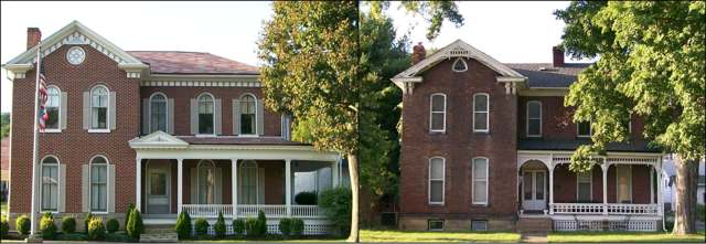
Photo: Bwsmith84, Wikimedia Commons, CC BY 3.0 · Wikimedia Commons
Local history sources: en.wikipedia.org · en.wikipedia.org · commons.wikimedia.org · archive.org
Historic places
1 place in Brookside on the National Register of Historic Places. Press a pin or a name for its whole record.
-
Frasier, Thomas T. and Wesley B. HousesBuilding · Brookside · listed 1982
- Address
- 898 and 920 National Rd.
- Where
- Brookside, Belmont County · ZIP 43912
- What it is
- Building
- Listed on the National Register
- 1982
- NRIS reference number
- 82001359
- Coordinates
- 40.07094, -80.75940
National Register file (NPS) ↗ Search Wikipedia ↗ Street map and directions ↗ On the Cracked Buckeye map
Source: National Park Service, National Register of Historic Places point file. The listing year is shown where NPS's certification date agrees with the listing's reference number. Listing recognizes significance; it does not restrict a private owner.
Water
A well in the Ohio River valley (alluvial) aquifer serving the St. Clairsville-area system The water here
- Belmont Co. Sanitary District 357% of residentsOhio River valley aquifer (wells)
- Bridgeport Public Water System39% of residentsOhio River valley aquifer (wells)
- Martins Ferry Public Water System3% of residentsOhio River valley aquifer (wells)
- St. Clairsville, City Of0% of residentsSt. Clairsville Main & Provident Reservoirs (local runoff)
Hospitals, fire stations and more
Inside Brookside's boundary: 1 fire or EMS station and 1 spill case. Press a pin or a name for its whole record and its source.
Fire and EMS stations (1)
-
Brookside Fire DepartmentBridgeport
- Address
- 875 National Road, Bridgeport, OH 43912
- Coordinates
- 40.07043, -80.76044
USGS National Map structures (source) ↗ Street map and directions ↗
Source: USGS National Map structures (most Ohio records last updated 2019 to 2022), checked against the Columbus and Cleveland station lists. The department that answers a call is set by jurisdiction and mutual aid, not by distance.
Spills reported since 2021 (1)
-
Sludge (Non-Sewage) Reached water2023-04-26 · Pease Twp
- Reported
- 2023-04-26
- What spilled
- Sludge (Non-Sewage)
- Reached a waterway
- Slaughterhouse Run
- Where
- Pease Twp, Belmont County
- Ohio EPA district office
- SEDO
- Ohio EPA case number
- 2304EPA0000671
Ohio EPA spill reports (source) ↗ Street map and directions ↗
Source: Ohio EPA emergency response spill reports, 2021 to September 2026, one point per case where Ohio EPA placed it. A report is what the caller or responder recorded; amounts are often blank or estimated.
Its ZIP codes
Each ZIP code that touches Brookside, with the share of its residents who live here and the same headline figures as the ZIP page.
| ZIP | Share | Water | Radon | Home value | Schools | Flood |
|---|---|---|---|---|---|---|
| 43912 Pease Township and Bridgeport | 9% | A well in the Ohio River valley (alluvial) aquifer serving the St. Clairsville-area system | 4.0 pCi/L average radon | Median year built 1930 | Bridgeport Exempted Village · 3 stars overall | 11% of residents in the 1% floodplain |
Local government
Who holds office in Brookside, how its elections and ballot issues came out, and the state auditor's record.
Money issues on the ballot since 2017: 2 of 2 passed; of those asking for new or higher taxes, 1 of 1.
Ballot issues
| Date | Issue | For | Against | Result |
|---|---|---|---|---|
| 2021-11-02 | Issue: Brookside Village Fire Levy | 110 | 39 | Passed (73.83% for), unofficial |
| 2021-11-02 | Issue: Brookside Village Marihuana Ordinance | 74 | 76 | Failed (49.33% for), unofficial |
| 2018-11-06 | Issue: Brookside Village - Current Operating Expenses - Renewal | 171 | 60 | Passed (74.03% for) |
| 2017-11-07 | Issue: Brookside Village Current Operating Expenses - Additional Levy | 104 | 30 | Passed (77.61% for) |
Elections for office
| Date | Office | Candidates and votes |
|---|---|---|
| 2021-11-02 | Village Council (unofficial count) | Paula Curtin 91, 25.63%; Sara Mudrick 81, 22.82%; Michael L. Tully 79, 22.25%; Paul D. West 104, 29.3% |
| 2021-11-02 | Mayor (unofficial count) | Richard L. Kurner 137, 100.0% |
| 2019-11-05 | Village Council | Roger W. Stewart 111, 100.0% |
| 2019-11-05 | Mayor | Roy L. Terek 115, 100.0% |
| 2015-11-03 | Village Council | Robert D. Weaver 163, 100.0% |
| 2015-11-03 | Mayor | Roy L. Terek 176, 100.0% |
Winners in bold. Results from the county board of elections' official canvass unless marked.
The county
Belmont County: 23 ZIP codes, 29 cities, villages and townships, 64,982 people.
Nearby places
Rain and snow
How much has actually fallen on Brookside, day by day, from 1878 to now. Daily totals, not averages.
- rain, last 30 days
- 2.57 in
- 2026-09-30 to 2026-10-29
- rain so far in 2026
- 44.4 in
- 8.9 in above normal for the date
- snow so far in 2026
- 22.0 in
- a normal year brings 22.9 in
- a normal year
- 41.9 in
- average of 30 years, 1991-2020
| Month | Rain (in) | Snow (in) | Days counted |
|---|---|---|---|
| October 2026 | 2.57 | — | 29 |
| September 2026 | 5.26 | — | 30 |
| August 2026 | 8.74 | — | 31 |
| July 2026 | 3.62 | — | 31 |
| June 2026 | 5.09 | — | 30 |
| May 2026 | 5.25 | — | 31 |
| April 2026 | 4.90 | — | 30 |
| March 2026 | 6.43 | 3.5 | 31 |
| February 2026 | 0.69 | 3.1 | 28 |
| January 2026 | 1.82 | 15.5 | 31 |
| December 2025 | 2.01 | 11.8 | 31 |
| November 2025 | 2.15 | — | 30 |
| Wettest year | 2018 — 66.6 in |
|---|---|
| Driest year | 1930 — 24.2 in |
| Snowiest year | 2003 — 58.8 in |
| Wettest day on record | 18 September 2004 — 5.53 in |
| Heaviest snowfall in a day | 17 December 1890 — 17.01 in |
| Deepest snow on the ground | 29 November 1950 — 24.00 in |
Estimated, not measured. No rain gauge has ever stood inside Brookside, so every figure here is worked out from the gauges around it - the nearest ones weighted most. Treat them as close estimates rather than readings.
51,991 days of records, 1878-02-01 to 2026-10-29. Source: NOAA NCEI GHCN-Daily, 3,240 gauges in and around Ohio. A day is "gauged" when a gauge standing inside the boundary reported it, and the value is the mean of those gauges. Otherwise it is interpolated by inverse distance from every gauge reporting within 50 miles. Nothing is carried forward, back-filled or smoothed. Against NOAA nClimDiv county monthly precipitation over 136,848 complete county-months (checked 2026-10-31): correlation 0.9515, median absolute difference 0.217 in a month. Built 2026-10-31 from the Cracked Buckeye precipitation archive. Snow is the softer number — snowfall is measured by hand with a ruler, no agency publishes a gridded county snowfall series, and blowing snow defeats every observer.
Environmental permits and filings
What Ohio EPA has on file for Brookside: permits, inspections, violations, cleanups and the state loans behind sewer and water work. Every line links to the agency's own document.
- facilities and sites on file
- 1
- those placed on the map inside Brookside
| Program | Facilities and sites |
|---|---|
| Hazardous waste | 1 |
Source: Ohio EPA eDocument portal (edocpub.epa.ohio.gov), indexed 2026-10-14. Facilities are placed on the map from Ohio EPA's own map layers, EPA's Facility Registry, coordinates written in the filings, or a geocoded street address. A permit filed under a private person's name (most are household septic systems) is counted but never named, placed or linked; licenses for individual workers and open-burning notices are left out entirely.
Quick answers
What county is Brookside, Ohio in?
Brookside is a village in Belmont County, Ohio, with 529 residents.
How did Brookside, Ohio get its name?
The reason for the name is not recorded.
What ZIP code is Brookside, Ohio?
Most of Brookside is in ZIP code 43912.
Where does Brookside, Ohio get its water?
The main water source for Brookside (Belmont Co. Sanitary District 3): A well in the Ohio River valley (alluvial) aquifer serving the St. Clairsville-area system.
Cite this page
Cite this page as:
Cracked Buckeye, "Brookside, Belmont County", https://crackedbuckeye.com/place/brookside/, built 2026-10-31, accessed [date].
How to cite · Report a correction · Built 2026-10-31
