Local events in Martins Ferry
20 events in the next 90 days from 1 public calendar. All local events in Martins Ferry
Checked October 20; the events page is refreshed daily.
Lakes near Martins Ferry
The history under the water: the valley before, the dam, the stories. All Ohio lakes
Notable Ohioans tied to Martins Ferry
Born, lived, worked or buried here, each with a sourced profile. All notable Ohioans

History from Martins Ferry
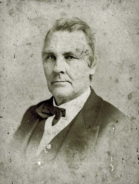
People and inventions tied to this place, each with its sources. All people · All inventions
How Martins Ferry began
Martins Ferry claims to be the oldest European settlement in Ohio, tracing squatter settlement to at least 1779 on land the Ohio Company had received as a 1748 royal land grant, opposite Fort Henry at Wheeling. The town went through five names before settling on its present one: Zanesburg, Hoglinstown, Mercertown, Norristown when Absalom Martin platted it in 1785, then Jefferson when he replatted it in 1795. Martin operated a ferry across the Ohio River there, and when his son Ebenezer redesigned the town on a grid in 1835 it became Martinsville, finally renamed Martin's Ferry in 1865 when it incorporated as a village; it chartered as a city in 1885. Like its Belmont County neighbors, it industrialized fast, becoming a rail and river hub in the late nineteenth and early twentieth centuries before deindustrialization thinned its population in the decades since.
Settled by 1779 (squatter settlement), platted 1785 (as Norristown); replatted 1795 (as Jefferson) and 1835 (as Martinsville), incorporated 1865 (village, as Martin's Ferry); 1885 (city), by Absalom Martin (1785, 1795 plattings); his son Ebenezer Martin (1835 replatting).
Where the name comes from
The city is named for Ebenezer Martin's father, Absalom Martin, who platted the original town (first as Norristown in 1785, then as Jefferson in 1795) and operated a ferry across the Ohio River there; when Ebenezer's 1835 grid-plan town of Martinsville was later renamed, it became Martin's Ferry in his father's honor.
Before the town
No Native village, camp, or trail specific to the present site of Martins Ferry is documented in the sources consulted; the settlement's earliest history is framed instead around its opposition to a Native claim rather than a Native presence on the ground. The land had been part of a 200,000-acre grant the Ohio Company received from the British Crown in 1748, but the Treaty of Fort Stanwix (1768) initially barred settlement of it, and the squatters who arrived by 1779, opposite Fort Henry on the Virginia (later West Virginia) side, were doing so on land not yet legally opened by treaty; the Ohio Company itself dissolved in 1779. Belmont County's broader Ohio River frontage, including the Martins Ferry area, lay within the shared range of the Lenape (Delaware), Shawnee, and Mingo through the eighteenth century. The 1774 violence at nearby Captina Creek helped trigger Lord Dunmore's War.
Timeline
- — The Ohio Company receives a 200,000-acre royal land grant from the British Crown covering the future site of Martins Ferry.
- — Fort Henry is built on the Virginia side of the Ohio River opposite the future Martins Ferry site.
- — Squatters are settled on the site by this date, making it, by local tradition, the oldest European settlement in Ohio; the Ohio Company dissolves the same year.
- — Absalom Martin plats the town as Norristown.
- — Martin replats the town as Jefferson and operates a ferry across the Ohio River there.
- — Absalom Martin's son Ebenezer redesigns the town on a grid street system and renames it Martinsville.
- — The town incorporates as a village and is renamed Martin's Ferry, honoring Absalom Martin's ferry.
- — Martins Ferry is chartered as a city.
- — Postcard photographs of North Fourth Street and a bird's-eye view of the city, later digitized by the Columbus Metropolitan Library, document the city's downtown and its iron bridge across the Ohio River.
Stories
Five names before the ferry stuck
Few Ohio towns changed names as often as Martins Ferry did before its present one took hold. Squatters were already on the ground by 1779, on land the British Crown had granted the Ohio Company in 1748 but that an earlier treaty had barred from settlement, so the earliest names, Zanesburg, Hoglinstown, Mercertown, were informal and shifting. Absalom Martin gave the place its first formal plat in 1785 as Norristown, then replatted it a decade later as Jefferson, the same year he began operating a ferry across the Ohio River to Fort Henry's old site on the Virginia shore. It took another generation before his son Ebenezer redrew the town on a modern grid in 1835 and called it Martinsville; only in 1865, when the community incorporated as a village, did it settle on Martin's Ferry, finally naming itself for the crossing that had defined it from the start.
Photographs
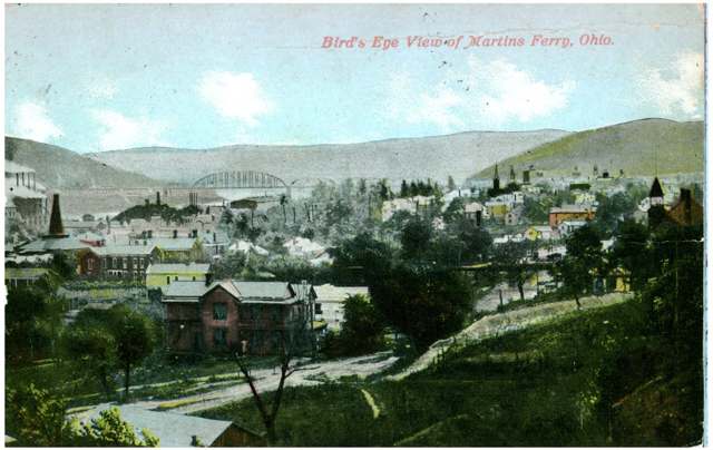
Photo: Columbus Metropolitan Library, via Digital Public Library of America / Ohio Digital Network, public domain · Wikimedia Commons
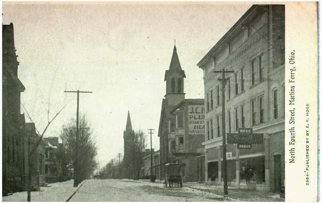
Photo: Columbus Metropolitan Library, via Digital Public Library of America / Ohio Digital Network, public domain · Wikimedia Commons
Local history sources: en.wikipedia.org · en.wikipedia.org · commons.wikimedia.org · commons.wikimedia.org
Historic places
1 place in Martins Ferry on the National Register of Historic Places. Press a pin or a name for its whole record.
-
Finney-Darrah HouseBuilding · Martin's Ferry · listed 1982
- Address
- Scenary Hill
- Where
- Martin's Ferry, Belmont County · ZIP 43935
- What it is
- Building
- Listed on the National Register
- 1982
- NRIS reference number
- 82003546
- Coordinates
- 40.10062, -80.73912
National Register file (NPS) ↗ Search Wikipedia ↗ Street map and directions ↗ On the Cracked Buckeye map
Source: National Park Service, National Register of Historic Places point file. The listing year is shown where NPS's certification date agrees with the listing's reference number. Listing recognizes significance; it does not restrict a private owner.
Water
Ohio River valley aquifer (wells) The water here
- Martins Ferry Public Water System100% of residentsOhio River valley aquifer (wells)
Hospitals, fire stations and more
Inside Martins Ferry's boundary: 1 health center, 4 fire and EMS stations, 3 public schools, 3 private schools, 2 libraries, 1 museum, 1 police station, 2 Superfund sites, 2 Toxics Release Inventory facilities and 3 spill cases. Press a pin or a name for its whole record and its source.
Community health centers (1)
-
Southeast, Inc. - Martins Ferry Health CenterHealth center · Martins Ferry
- Run by
- a federally qualified health center
- Setting
- Clinic
- City
- Martins Ferry
- Coordinates
- 40.09477, -80.72424
Find a Health Center (HRSA) ↗ HRSA data (source) ↗ Street map and directions ↗
Source: HRSA health center service delivery sites, active, September 2026 (school-based sites left out). Health centers see patients whether or not they have insurance, with fees on a sliding scale.
Fire and EMS stations (4)
-
Martins Ferry Fire Department Alert Engine Company Engine 1Martins Ferry
- Address
- 201 North Zane Highway, Martins Ferry, OH 43935
- Coordinates
- 40.09877, -80.72381
USGS National Map structures (source) ↗ Street map and directions ↗
-
Martins Ferry Fire Department Liberty Engine Company Engine 3Martins Ferry
- Address
- 500 Center Street, Martins Ferry, OH 43935
- Coordinates
- 40.10142, -80.71851
USGS National Map structures (source) ↗ Street map and directions ↗
-
Martins Ferry Fire Department Station 28 Ladder CompanyMartins Ferry
- Address
- 214 South 4th Street, Martins Ferry, OH 43935
- Coordinates
- 40.09433, -80.72579
USGS National Map structures (source) ↗ Street map and directions ↗
-
Martins Ferry Fire Department Station 28 Vigilant Engine CompanyMartins Ferry
- Address
- 901 Pearl Street, Martins Ferry, OH 43935
- Coordinates
- 40.09061, -80.73251
USGS National Map structures (source) ↗ Street map and directions ↗
Source: USGS National Map structures (most Ohio records last updated 2019 to 2022), checked against the Columbus and Cleveland station lists. The department that answers a call is set by jurisdiction and mutual aid, not by distance.
Public schools (3)
-
Anna Marie Ayers Elementary School3 of 5 stars · Martins
- Address
- 5002 Ayers Lime Stone Rd, Martins, OH 43935
- School district
- Martins Ferry City School District
- Kind (NCES)
- Regular School
- Students, 2023-24
- 527
- Teachers (full-time equivalent)
- 28
- Report card, 2025-26
- 3 of 5 stars
- Performance index
- 79.1%
- Ohio building IRN
- 010004
- NCES school ID
- 390443405465
NCES school record ↗ Ohio School Report Card ↗ Street map and directions ↗
-
Martins Ferry High School3 of 5 stars · Martins Ferry
- Address
- 5000 Ayers Lime Stone Rd, Martins Ferry, OH 43935
- School district
- Martins Ferry City School District
- Kind (NCES)
- Regular School
- Students, 2023-24
- 380
- Teachers (full-time equivalent)
- 30
- Report card, 2025-26
- 3 of 5 stars
- Performance index
- 74.3%
- Four-year graduation rate
- 93.5%
- Ohio building IRN
- 023036
- NCES school ID
- 390443401272
NCES school record ↗ Ohio School Report Card ↗ Street map and directions ↗
-
Martins Ferry Middle School4 of 5 stars · Martins Ferry
- Address
- 5000 Ayers Limestone Rd, Martins Ferry, OH 43935
- School district
- Martins Ferry City School District
- Kind (NCES)
- Regular School
- Students, 2023-24
- 403
- Teachers (full-time equivalent)
- 21
- Report card, 2025-26
- 4 of 5 stars
- Performance index
- 73.7%
- Ohio building IRN
- 010314
- NCES school ID
- 390443401270
NCES school record ↗ Ohio School Report Card ↗ Street map and directions ↗
Source: NCES EDGE public school locations 2024-25 and Common Core of Data 2023-24 (type, students, teachers); Ohio School Report Cards 2025-26 (Department of Education and Workforce), matched by name within the district.
Private schools (3)
-
Martins Ferry Christian SchoolPrivate, conservative Christian · Martins Ferry
- Address
- 710 S Zane Hwy, Martins Ferry, OH 43935
- Kind
- conservative Christian
- Students, 2023-24
- 44
- Teachers (full-time equivalent)
- 6
- Students per teacher
- 7.33333
- Phone
- (740) 633-0199
- NCES private school ID
- AB912245
-
Speiro AcademyPrivate, religious, independent · Martins Ferry
- Address
- 500 N 5Th St, Martins Ferry, OH 43935
- Kind
- religious, independent
- Students, 2023-24
- 26
- Teachers (full-time equivalent)
- 7.5
- Students per teacher
- 3.46667
- Phone
- (740) 738-0203
- NCES private school ID
- A1303709
-
St Mary Central SchoolPrivate, Catholic · Martins Ferry
- Address
- 24 N 4Th St, Martins Ferry, OH 43935
- Kind
- Catholic
- Students, 2023-24
- 88
- Teachers (full-time equivalent)
- 11.1
- Students per teacher
- 7.92793
- Phone
- (740) 633-5424
- NCES private school ID
- 01060284
Source: NCES Private School Survey 2023-24.
Public libraries (2)
-
Martins Ferry Public LibraryCentral library · Martins Ferry
- Address
- 20 S. Fifth St., Martins Ferry, OH 43935
- What it is
- Central library
- Library system
- Belmont County District Library
- Open
- 3,120 hours a year, 52 weeks
- Building
- 32,130 sq ft
- System's visits, FY2024
- 74,932
- System's loans, FY2024
- 114,482
- People the system serves
- 33,295
- Phone
- (740) 633-0314
IMLS Public Libraries Survey (source) ↗ Street map and directions ↗
-
Martins Ferry Public LibraryBookmobile stop · Martins Ferry
- Address
- 20 S. Fifth St., Martins Ferry, OH 43935
- What it is
- Bookmobile stop
- Library system
- Belmont County District Library
- Open
- 208 hours a year, 52 weeks
- System's visits, FY2024
- 74,932
- System's loans, FY2024
- 114,482
- People the system serves
- 33,295
- Phone
- (740) 633-0314
IMLS Public Libraries Survey (source) ↗ Street map and directions ↗
Source: IMLS Public Libraries Survey FY2024 (outlets and their systems). Any Ohio resident can get a free card at any Ohio public library.
Museums, historical societies, gardens and zoos (1)
-
Martins Ferry Area Historical SocietyHistorical society · Martins Ferry
- What it is
- Historical society
- City
- Martins Ferry
- Coordinates
- 40.10116, -80.73728
Search Wikipedia ↗ IMLS Museum Data Files (source) ↗ Street map and directions ↗
The museum list is IMLS's 2018 file; a museum may have closed or moved since.
Source: IMLS Museum Data Files, 2018.
Police stations (1)
-
Martins Ferry Police DepartmentMartins Ferry
- Address
- 35 South 5th Street, Martins Ferry, OH 43935
- Coordinates
- 40.09640, -80.72456
USGS National Map structures (source) ↗ Street map and directions ↗
Source: USGS National Map structures, police stations, corrected and completed by hand (September 2026). The department that answers a call is set by jurisdiction, not by distance.
Superfund sites (2)
-
Former State Cleaners FacilitySuperfund program · Martins Ferry
- Address
- 1401 S. Zane Hwy., Martins Ferry, OH 43935
- County
- Belmont County
- Status
- Superfund program site, not on the National Priorities List
- EPA program ID
- OHD018164038
- EPA registry ID
- 110071102264
EPA facility record ↗ EPA Facility Registry Service (source) ↗ Street map and directions ↗
-
Rg Steel Wheeling LlcSuperfund program · Martins Ferry
- Address
- 1001 Main St, Martins Ferry, OH 43935
- County
- Belmont County
- Status
- Superfund program site, not on the National Priorities List
- EPA program ID
- OHD010448231
- EPA registry ID
- 110000384913
EPA facility record ↗ EPA Facility Registry Service (source) ↗ Street map and directions ↗
Source: EPA Facility Registry Service, Superfund (SEMS) and National Priorities List sites. Many program sites were assessed and needed no cleanup.
Facilities reporting toxic releases (2)
-
Allied NutrientsToxics Release Inventory · Martins Ferry
- Address
- 100 Picoma Rd, Martins Ferry, OH 43935
- County
- Belmont County
- Status
- Reports to the Toxics Release Inventory (active)
- EPA program ID
- 43935LSCMR100PI
- EPA registry ID
- 110038251496
EPA facility record ↗ EPA Facility Registry Service (source) ↗ Street map and directions ↗
-
Rg Steel Wheeling LlcToxics Release Inventory · Martins Ferry
- Address
- 1001 Main St, Martins Ferry, OH 43935
- County
- Belmont County
- Status
- Reports to the Toxics Release Inventory (active)
- EPA program ID
- 43935WHLNG1134M
- EPA registry ID
- 110000384913
EPA facility record ↗ EPA Facility Registry Service (source) ↗ Street map and directions ↗
Source: EPA Facility Registry Service, Toxics Release Inventory reporters. Reporting a release is required of large users of listed chemicals; it is not by itself a violation.
Spills reported since 2021 (3)
-
Sewage Sludge / Biosolids2024-10-30 · Martins Ferry
- Reported
- 2024-10-30
- What spilled
- Sewage Sludge / Biosolids
- Where
- Martins Ferry, Belmont County
- Ohio EPA district office
- SEDO
- Ohio EPA case number
- 2410EPA0001816
Ohio EPA spill reports (source) ↗ Street map and directions ↗
-
Milk Reached water2024-07-23 · Martins Ferry
- Reported
- 2024-07-23
- What spilled
- Milk
- Largest amount reported
- 7,000 gallons
- Reached a waterway
- 07 - Ohio River
- Where
- Martins Ferry, Belmont County
- Ohio EPA district office
- SEDO
- Ohio EPA case number
- 2407EPA0001254
Ohio EPA spill reports (source) ↗ Street map and directions ↗
-
Contaminated Material Reached water2024-04-04 · Martins Ferry
- Reported
- 2024-04-04
- What spilled
- Contaminated Material; Hazardous Waste Nos (Not Specified)
- Reached a waterway
- 07 - Ohio River
- Where
- Martins Ferry, Belmont County
- Ohio EPA district office
- SEDO
- Ohio EPA case number
- 2404EPA0000533
Ohio EPA spill reports (source) ↗ Street map and directions ↗
Source: Ohio EPA emergency response spill reports, 2021 to September 2026, one point per case where Ohio EPA placed it. A report is what the caller or responder recorded; amounts are often blank or estimated.
Its ZIP codes
Each ZIP code that touches Martins Ferry, with the share of its residents who live here and the same headline figures as the ZIP page.
| ZIP | Share | Water | Radon | Home value | Schools | Flood |
|---|---|---|---|---|---|---|
| 43935 Martins Ferry | 78% | Ohio River valley aquifer (wells) | 3.4 pCi/L average radon | Median year built 1922 | Martins Ferry City · 3 stars overall | 2.7% of residents in the 1% floodplain |
Local government
How its elections and ballot issues came out and the state auditor's record.
Money issues on the ballot since 2015: 3 of 4 passed; of those asking for new or higher taxes, 0 of 1.
Ballot issues
| Date | Issue | For | Against | Result |
|---|---|---|---|---|
| 2021-11-02 | Issue: City of Martins Ferry Marihuana Ordinance | 435 | 404 | Passed (51.85% for), unofficial |
| 2020-11-03 | Issue: Martins Ferry City Police Levy | 1,401 | 1,068 | Passed (56.74% for) |
| 2020-11-03 | Issue: Martins Ferry City Fire Levy | 1,415 | 1,056 | Passed (57.26% for) |
| 2019-11-05 | Issue: City of Martins Ferry - EMS - Additional | 569 | 458 | Passed (55.4% for) |
| 2018-11-06 | Issue: City of Martins Ferry - EMS - Additional | 793 | 997 | Failed (44.3% for) |
| 2016-11-08 | Issue: City of Martins Ferry - Additional Police | 1,320 | 1,135 | Passed (53.77% for) |
| 2015-11-03 | Issue: City of Martins Ferry - Fire Renewal Levy | 876 | 562 | Passed (60.92% for) |
| 2015-11-03 | Issue: City of Martins Ferry - Police Additional Levy | 613 | 822 | Failed (42.72% for) |
Elections for office
| Date | Office | Candidates and votes |
|---|---|---|
| 2021-11-02 | Treasurer (unofficial count) | Susan M. Yeso 635, 100.0% |
| 2021-11-02 | Third Ward Council (unofficial count) | Suzanne C. Armstrong (DEM) 123, 100.0% |
| 2021-11-02 | Second Ward Council (unofficial count) | Bruce Shrodes (REP) 176, 100.0% |
| 2021-11-02 | President of Council (unofficial count) | Kristine Davis (DEM) 639, 100.0% |
| 2021-11-02 | Fourth Ward Council (unofficial count) | Rick Rodgers (DEM) 123, 100.0% |
| 2021-11-02 | First Ward Council (unofficial count) | Robert P. Hunker (REP) 194, 100.0% |
| 2021-11-02 | Council at Large (unofficial count) | Thomas J. Burns (DEM) 383, 28.24%; John A. Regis Sr. (DEM) 491, 36.21%; Jim Schramm (DEM) 482, 35.55% |
| 2021-05-04 | Fourth Ward Council (DEM primary) | Rick Rodgers 41, 66.13%; Pamela Shrodes 21, 33.87% |
| 2019-11-05 | Treasurer | Rhonda S. Bernardo 794, 100.0% |
| 2019-11-05 | Third Ward Council | Suzanne C. Armstrong (DEM) 153, 100.0% |
| 2019-11-05 | Second Ward Council | Bruce Shrodes (REP) 200, 100.0% |
| 2019-11-05 | President of Council | Kristine Davis (DEM) 795, 100.0% |
| 2019-11-05 | Mayor | John R. Davies 555, 51.97%; Robert T. Krajnyak (DEM) 513, 48.03% |
| 2019-11-05 | Fourth Ward Council | Rick Rodgers (DEM) 164, 100.0% |
| 2019-11-05 | First Ward Council | Robert P. Hunker (REP) 233, 100.0% |
| 2019-11-05 | Director of Law | Paul W. Stecker Jr. (REP) 799, 100.0% |
| 2019-11-05 | Council at Large | Thomas J. Burns (DEM) 487, 29.09%; Jack Regis Sr. (DEM) 597, 35.66%; Jim Schramm (DEM) 590, 35.24% |
| 2019-11-05 | Auditor | Rita K. Randall (DEM) 773, 100.0% |
| 2019-05-07 | Fourth Ward Council (DEM primary) | Larry A. Deaton 24, 48.98%; Rick Rodgers 25, 51.02% |
| 2017-11-07 | Third Ward Council | Suzanne Armstrong (DEM) 155, 100.0% |
| 2017-11-07 | Second Ward Council | Bruce Shrodes (REP) 203, 100.0% |
| 2017-11-07 | President of Council | Kristine Davis (DEM) 716, 100.0% |
| 2017-11-07 | Fourth Ward Council | Rick Rodgers (DEM) 145, 100.0% |
| 2017-11-07 | First Ward Council | Robert P. Hunker (DEM) 211, 100.0% |
| 2017-11-07 | Council at Large | Jim Schramm (DEM) 569, 28.39%; Jack Regis (DEM) 565, 28.19%; Thomas J. Burns (DEM) 476, 23.75%; Benjamin Neiman 394, 19.66% |
Winners in bold. Results from the county board of elections' official canvass unless marked. The county's results on file run through 2024-03-19; later elections are not loaded yet.
Auditor of State record
- No fiscal caution, watch or emergency on the Auditor of State's lists.
- Financial Health Indicators (the Auditor of State's 17 measures; critical / cautionary / positive): 2020 0 / 2 / 15; 2021 0 / 5 / 12; 2022 1 / 6 / 10; 2023 1 / 1 / 15; 2024 2 / 2 / 13; 2025 3 / 2 / 11.
- Financial Audit, 2024, released 2025-12-18
- Financial Audit, 2023, released 2024-11-07
On the November 3, 2026 ballot
Statewide question: State Issue 3: Voter ID
Local questions for Martins Ferry, Belmont County and its school district:
- Martins Ferry City School District: Authorizes an additional 0.75% income tax for the current expenses of Martins Ferry City School District for 5 years, beginning January 1, 2027.
- Belmont County: Renews and decreases a 0.75-mill property tax levy for the provide & maintain senior citizens services or facilities of Belmont County for 5 years, beginning in 2027.
- Belmont County: Renews a 0.75-mill property tax levy to maintain & operate 9-1-1 system of Belmont County for 5 years, beginning in 2027.
Races, candidates and every question for an address: your ballot. County offices and judges are on your county board's sample ballot.
The county
Belmont County: 23 ZIP codes, 29 cities, villages and townships with pages here, 64,434 people (Census Bureau estimate, July 2025).
Nearby places
Rain and snow
How much has actually fallen on Martins Ferry, day by day, from 1878 to now. Daily totals, not averages.
- rain, last 30 days
- 2.40 in
- 2026-10-01 to 2026-10-30
- rain so far in 2026
- 43.5 in
- 8.3 in above normal for the date
- snow so far in 2026
- 21.1 in
- a normal year brings 21.1 in
- a normal year
- 41.5 in
- average of 30 years, 1991-2020
| Month | Rain (in) | Snow (in) | Days counted |
|---|---|---|---|
| October 2026 | 2.40 | — | 30 |
| September 2026 | 5.15 | — | 30 |
| August 2026 | 9.31 | — | 31 |
| July 2026 | 3.43 | — | 31 |
| June 2026 | 4.38 | — | 30 |
| May 2026 | 5.08 | — | 31 |
| April 2026 | 4.66 | 0.0 | 30 |
| March 2026 | 6.66 | 3.0 | 31 |
| February 2026 | 0.72 | 2.8 | 28 |
| January 2026 | 1.76 | 15.2 | 31 |
| December 2025 | 1.98 | 11.7 | 31 |
| November 2025 | 2.37 | — | 30 |
| Wettest year (estimated) | 2018 — 64.9 in |
|---|---|
| Driest year (estimated) | 1930 — 24.1 in |
| Wettest day (estimated) | 18 September 2004 — 5.46 in |
| Heaviest snowfall in a day (estimated) | 25 November 1950 — 18.49 in |
| Deepest snow on the ground (estimated) | 29 November 1950 — 25.54 in |
Estimated, not measured. No rain gauge has ever stood inside Martins Ferry, so every figure here is worked out from the gauges around it - the nearest ones weighted most. Treat them as close estimates rather than readings.
51,934 days of records, 1878-02-01 to 2026-10-30. Source: NOAA NCEI GHCN-Daily, 3,240 gauges in and around Ohio. A day is "gauged" when a gauge standing inside the boundary reported it, and the value is the mean of those gauges. Otherwise it is interpolated by inverse distance from every gauge reporting within 50 miles. Nothing is carried forward, back-filled or smoothed. Against NOAA nClimDiv county monthly precipitation over 136,848 complete county-months (checked 2026-11-01): correlation 0.9515, median absolute difference 0.217 in a month. Built 2026-11-01 from the Cracked Buckeye precipitation archive. Snow is the softer number — snowfall is measured by hand with a ruler, no agency publishes a gridded county snowfall series, and blowing snow defeats every observer.
Environmental permits and filings
What Ohio EPA has on file for Martins Ferry: permits, inspections, violations, cleanups and the state loans behind sewer and water work. Every line links to the agency's own document.
- facilities and sites on file
- 50
- those placed on the map inside Martins Ferry
| Program | Facilities and sites |
|---|---|
| Hazardous waste | 18 |
| Air pollution | 10 |
| Contaminated-site cleanup | 9 |
| Site assessment | 5 |
| State water loans | 4 |
| Public drinking water | 1 |
| Source-water protection | 1 |
| State sewer loans | 1 |
| Voluntary cleanup | 1 |
| Date | Facility or site | What |
|---|---|---|
| MARTINS FERRY WTP | Public drinking water notice of violation | |
| MARTINS FERRY PUBLIC WATER SYSTEM PWS | Source-water protection report | |
| MARTINS FERRY PUBLIC WATER SYSTEM PWS | Public drinking water compliance letter | |
| MARTINS FERRY PUBLIC WATER SYSTEM PWS | Public drinking water warning letter | |
| TURF CARE SUPPLY CORP | Air pollution report | |
| MARTINS FERRY PUBLIC WATER SYSTEM PWS | Public drinking water report | |
| MARTINS FERRY PUBLIC WATER SYSTEM PWS | Public drinking water notice of violation | |
| AUSTIN MASTER SERVICES LLC | Air pollution report | |
| ARROWSTRIP INC | Air pollution report | |
| MARTINS FERRY PUBLIC WATER SYSTEM PWS | Public drinking water notice of violation | |
| MARTINS FERRY PUBLIC WATER SYSTEM PWS | Public drinking water warning letter | |
| MARTINS FERRY PUBLIC WATER SYSTEM PWS | Public drinking water plan | |
| MARTINS FERRY PUBLIC WATER SYSTEM PWS | Public drinking water plan | |
| NLS ASPHALT INC (GENSET) | Air pollution permit | |
| APPROVED SITE SERVICE | Hazardous waste notice of violation | |
| MARTINS FERRY PUBLIC WATER SYSTEM PWS | Public drinking water inspection | |
| MARTINS FERRY PUBLIC WATER SYSTEM PWS | Public drinking water notice of violation | |
| MARTINS FERRY PUBLIC WATER SYSTEM PWS | Public drinking water notice of violation | |
| MARTINS FERRY PUBLIC WATER SYSTEM PWS | Public drinking water inspection | |
| MARTINS FERRY PUBLIC WATER SYSTEM PWS | Public drinking water compliance letter | |
| MARTINS FERRY PUBLIC WATER SYSTEM PWS | Public drinking water notice of violation | |
| MARTINS FERRY PUBLIC WATER SYSTEM PWS | Public drinking water report | |
| NICKLES BAKERY OF MARTINS FERRY INC | Air pollution inspection | |
| WILSON BLACKTOP CORP | Air pollution notice of violation | |
| MARTINS FERRY PUBLIC WATER SYSTEM PWS | Public drinking water notice of violation |
Source: Ohio EPA eDocument portal (edocpub.epa.ohio.gov), indexed 2026-10-14. Facilities are placed on the map from Ohio EPA's own map layers, EPA's Facility Registry, coordinates written in the filings, or a geocoded street address. A permit filed under a private person's name (most are household septic systems) is counted but never named, placed or linked; licenses for individual workers and open-burning notices are left out entirely.
Quick answers
What county is Martins Ferry, Ohio in?
Martins Ferry is a city in Belmont County, Ohio, with 6,241 residents.
When was Martins Ferry, Ohio founded?
Martins Ferry was settled by 1779 (squatter settlement); laid out 1785 (as Norristown); replatted 1795 (as Jefferson) and 1835 (as Martinsville); incorporated 1865 (village, as Martin's Ferry); 1885 (city). Founders on record: Absalom Martin (1785, 1795 plattings); his son Ebenezer Martin (1835 replatting). Source
How did Martins Ferry, Ohio get its name?
The city is named for Ebenezer Martin's father, Absalom Martin, who platted the original town (first as Norristown in 1785, then as Jefferson in 1795) and operated a ferry across the Ohio River there; when Ebenezer's 1835 grid-plan town of Martinsville was later renamed, it became Martin's Ferry in his father's honor. Source
What ZIP code is Martins Ferry, Ohio?
Most of Martins Ferry is in ZIP code 43935.
Where does Martins Ferry, Ohio get its water?
The main water source for Martins Ferry (Martins Ferry Public Water System): Ohio River valley aquifer (wells).
Cite this page
Cite this page as:
Cracked Buckeye, "Martins Ferry, Belmont County", https://crackedbuckeye.com/place/martins-ferry/, built 2026-10-31, accessed [date].
How to cite · Report a correction · Built 2026-10-31