Local events in Colerain Township, Belmont County
Nothing is posted for Colerain Township itself yet; here is what is on within 10 miles. All local events in Colerain Township, Belmont County
Know a calendar we should watch? Send the link
Checked October 20; the events page is refreshed daily.
How Colerain Township, Belmont County began
Colerain Township, in northeastern Belmont County, was organized in 1808 and named for Coleraine in Northern Ireland. A Quaker meeting founded in 1801 by Friends who had emigrated largely from North Carolina and Virginia specifically to escape living among slavery built the Concord Hicksite Friends Meeting House on Negus Road in 1815, a plain brick building that is the township's only National Register-listed site; the congregation split almost entirely to the Hicksite side of American Quakerism's 1828 schism. The township today holds the unincorporated communities of Barton, Colerain, and Maynard.
Incorporated 1808, by Belmont County commissioners.
Where the name comes from
Named for Coleraine, a town in Northern Ireland.
Before the town
The 1903 county history says Captain Williams, the celebrated Indian hunter and one of the defenders of Fort Henry at Wheeling, was killed by Indians on what was afterward the Majors farm in 1780 while out on a survey or scout, and that evidences of settlement in the township go back to 1785, in advance of the government survey. No Native village, mound or trail is recorded in the township.
Timeline
- — Captain Williams, a noted Indian hunter and defender of Fort Henry, was killed by Indians on what became the Majors farm while out on a survey or scout.
- — A house was recorded near Farmington, two years before the government survey.
- — Wells and Satterthwaite bought the first farm from the government, later Abner Barton's and the site of the town of Barton.
- — The first school was built on Archibald Major's farm, and children walked long distances over dangerous paths; Hugh Parks's tannery in section 18 was established about then and ran for half a century.
- — A Quaker meeting is founded in the township by Friends who had emigrated largely from North Carolina and Virginia to escape living in a slaveholding society.
- — John Harris built the first flour mill, in section 24, which was used for forty years and was a landmark for half a century.
- — Colerain Township is organized and named for Coleraine, Northern Ireland.
- — Josiah Fox, who the county history says built Old Ironsides, moved to the Quaker settlement and lost his right of membership in the Society of Friends for building warships.
- — The Concord Friends Meeting House, a plain brick building on a stone foundation, is built on Negus Road.
- — Daniel McPeak laid out Farmington hoping the National Road would pass through it, but the road went three miles south and the effort was abandoned.
- — American Quakerism splits nationally between Orthodox and Hicksite followers of Elias Hicks; at Concord, virtually none of the members remain in communion with the Orthodox meetings, and the building becomes known as the Concord Hicksite Friends Meeting House.
- — A cholera epidemic nearly emptied the town of Gambletown in section 8, which ceased to exist.
- — Maynard, or New Pittsburg, had more than 400 residents, mostly miners for the Lorain Coal and Dock Company, with coal mines also at Barton and Crescent.
- — The Concord Hicksite Friends Meeting House is added to the National Register of Historic Places on July 23, the township's only listed site.
- — The census counted 4,174 residents in the 25-square-mile township with no incorporated municipality.
Stories
A meeting house built by people fleeing slavery's presence
The Quakers who founded the Concord meeting in Colerain Township in 1801 were not fleeing persecution of their own faith so much as the society built around slavery: they came largely from North Carolina and Virginia, slaveholding states, specifically to settle somewhere they would not have to live alongside the institution. By 1815 the congregation was established enough to build a permanent home, a brick meeting house on Negus Road. The meeting's convictions showed again in 1828, when the wider Religious Society of Friends split nationally between Orthodox and Hicksite followers of the reformer Elias Hicks; at Concord the break was nearly total, with almost no member staying in communion with the Orthodox side. The building the congregation raised still stands, Colerain Township's only site on the National Register of Historic Places.
The town that bet on the National Road
Farmington was laid out in 1818 by Daniel McPeak at the time the National Road was being planned, and its founder hoped to steer the road through it. Lots sold at high prices for that day. But when the great thoroughfare was fixed three miles south of the village, the effort was abandoned. A second would-be town, Gambletown in section 8, had been laid out several years before the county was organized, and a cholera epidemic in 1833 practically depopulated it. Meanwhile the Quaker village of Colerain, founded by Friends from North Carolina and Virginia who had freed their slaves and come north under the Ordinance of 1787, thrived quietly, and by 1903 it was a favorite summer resort for weary townspeople. Coal under the township brought mining towns at Barton, Maynard and Crescent in the 1890s.
Photographs
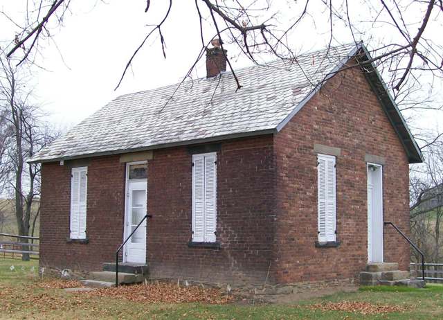
Photo: Bwsmith84, Wikimedia Commons, CC BY 3.0 · Wikimedia Commons
Local history sources: en.wikipedia.org · en.wikipedia.org · en.wikipedia.org · commons.wikimedia.org · archive.org
Historic places
1 place in Colerain Township, Belmont County on the National Register of Historic Places. Press a pin or a name for its whole record.
-
Concord Hicksite Friends Meeting HouseHistoric district · Colerain Township · listed 2009
- Address
- Negus Rd.
- Where
- Colerain Township, Belmont County · ZIP 43935
- What it is
- Historic district
- Listed on the National Register
- 2009
- NRIS reference number
- 09000562
- Coordinates
- 40.12490, -80.79522
National Register file (NPS) ↗ Search Wikipedia ↗ Street map and directions ↗ On the Cracked Buckeye map
Source: National Park Service, National Register of Historic Places point file. The listing year is shown where NPS's certification date agrees with the listing's reference number. Listing recognizes significance; it does not restrict a private owner.
Water
Mostly private wells The water here
- St. Clairsville, City Of30% of residentsSt. Clairsville Main & Provident Reservoirs (local runoff)
- Belmont Co. Sanitary District 328% of residentsOhio River valley aquifer (wells)
- Martins Ferry Public Water System18% of residentsOhio River valley aquifer (wells)
- Bridgeport Public Water System15% of residentsOhio River valley aquifer (wells)
- Dillonvale3% of residentsGroundwater wells (2 wells)
- Adena Village3% of residentsOhio River valley aquifer (wells)
- Tri-county Water Authority2% of residentsOhio River valley aquifer (wells)
- Mount Pleasant1% of residentsGroundwater wells (1 wells)
- Belmont Public Water System0% of residentsGroundwater wells (2 wells)
Hospitals, fire stations and more
Inside Colerain Township, Belmont County's boundary: 1 nursing home, 2 fire and EMS stations, 1 poor-rated bridge, 43 shale and injection wells, 1 Toxics Release Inventory facility and 4 spill cases. Press a pin or a name for its whole record and its source.
Nursing homes (1)
-
Sienna Hills Nursing & Rehabilitation3 of 5 stars · Adena
- Address
- 73841 Pleasant Grove Road, Adena, OH 43901
- Certified beds
- 43
- Residents on an average day
- 38
- Medicare overall rating
- 3 of 5 stars
- Health inspections
- 3 of 5 stars
- Staffing
- 1 of 5 stars
- Quality measures
- 5 of 5 stars
- Penalties since 2023
- none
- Ownership
- For profit - Corporation
- Chain
- HILLSTONE HEALTHCARE
- Takes
- Medicare and Medicaid
- Phone
- (740) 546-3013
- Medicare ID
- 365922
Medicare Care Compare ↗ CMS nursing home data (source) ↗ Street map and directions ↗
Source: CMS Care Compare nursing home provider and penalties files; Medicare star ratings run 1 to 5.
Fire and EMS stations (2)
-
Barton Volunteer Fire Department Station 13Barton
- Address
- 70706 Main Street, Barton, OH 43905
- Coordinates
- 40.10684, -80.84331
USGS National Map structures (source) ↗ Street map and directions ↗
-
Colerain Volunteer Fire CompanyColerain
- Address
- 72555 Colerain Road, Colerain, OH 43917
- Coordinates
- 40.12171, -80.80745
USGS National Map structures (source) ↗ Street map and directions ↗
Source: USGS National Map structures (most Ohio records last updated 2019 to 2022), checked against the Columbus and Cleveland station lists. The department that answers a call is set by jurisdiction and mutual aid, not by distance.
Bridges rated poor (1)
-
Ch 10 over Wheeling CreekPoor · built 1954
- Condition
- Poor: a deck, superstructure, substructure or culvert rated 4 or below on the 0 to 9 scale
- What it is
- Bridge
- Built
- 1954
- Length
- 47 ft
- Owner
- County
- Vehicles a day
- 805
- Coordinates
- 40.06921, -80.81954
National Bridge Inventory (source) ↗ Street map and directions ↗
Source: FHWA National Bridge Inventory 2025. "Poor" means one major part rated 4 or below on the 0 to 9 scale; it calls for repair, not closing, unless the state posts or closes the bridge.
Shale and injection wells (43)
-
Bakos Ne Clr Bl 9HUtica shale well
- What it is
- Utica shale well
- Drilled sideways
- Yes
- Operator
- Ascent Resources Utica Llc
- County
- Belmont County
- API well number
- 34013211400000
- Coordinates
- 40.14434, -80.85485
ODNR oil and gas wells (source) ↗ Street map and directions ↗
The point is the surface well head (the pad); a horizontal well runs a mile or more underground from it.
-
Bakos S Clr Bl 4HUtica shale well
- What it is
- Utica shale well
- Drilled sideways
- Yes
- Operator
- Ascent Resources Utica Llc
- County
- Belmont County
- API well number
- 34013214450000
- Coordinates
- 40.14438, -80.85477
ODNR oil and gas wells (source) ↗ Street map and directions ↗
The point is the surface well head (the pad); a horizontal well runs a mile or more underground from it.
-
Bakos S Clr Bl 6HUtica shale well
- What it is
- Utica shale well
- Drilled sideways
- Yes
- Operator
- Ascent Resources Utica Llc
- County
- Belmont County
- API well number
- 34013214460000
- Coordinates
- 40.14441, -80.85471
ODNR oil and gas wells (source) ↗ Street map and directions ↗
The point is the surface well head (the pad); a horizontal well runs a mile or more underground from it.
-
Bakos Se Clr Bl 10HUtica shale well
- What it is
- Utica shale well
- Drilled sideways
- Yes
- Operator
- Ascent Resources Utica Llc
- County
- Belmont County
- API well number
- 34013211370000
- Coordinates
- 40.14425, -80.85503
ODNR oil and gas wells (source) ↗ Street map and directions ↗
The point is the surface well head (the pad); a horizontal well runs a mile or more underground from it.
-
Bakos Se Clr Bl 8HUtica shale well
- What it is
- Utica shale well
- Drilled sideways
- Yes
- Operator
- Ascent Resources Utica Llc
- County
- Belmont County
- API well number
- 34013211390100
- Coordinates
- 40.14431, -80.85491
ODNR oil and gas wells (source) ↗ Street map and directions ↗
The point is the surface well head (the pad); a horizontal well runs a mile or more underground from it.
-
Bakos Sw Clr Bl 2HUtica shale well
- What it is
- Utica shale well
- Drilled sideways
- Yes
- Operator
- Ascent Resources Utica Llc
- County
- Belmont County
- API well number
- 34013211380000
- Coordinates
- 40.14428, -80.85497
ODNR oil and gas wells (source) ↗ Street map and directions ↗
The point is the surface well head (the pad); a horizontal well runs a mile or more underground from it.
-
Connie Jo E Clr Bl 3HUtica shale well
- What it is
- Utica shale well
- Drilled sideways
- Yes
- Operator
- Ascent Resources Utica Llc
- County
- Belmont County
- API well number
- 34013214400000
- Coordinates
- 40.13955, -80.83561
ODNR oil and gas wells (source) ↗ Street map and directions ↗
The point is the surface well head (the pad); a horizontal well runs a mile or more underground from it.
-
Connie Jo N Clr Bl 5HUtica shale well
- What it is
- Utica shale well
- Drilled sideways
- Yes
- Operator
- Ascent Resources Utica Llc
- County
- Belmont County
- API well number
- 34013214390000
- Coordinates
- 40.13959, -80.83557
ODNR oil and gas wells (source) ↗ Street map and directions ↗
The point is the surface well head (the pad); a horizontal well runs a mile or more underground from it.
-
Connie Jo W Clr Bl 1HUtica shale well
- What it is
- Utica shale well
- Drilled sideways
- Yes
- Operator
- Ascent Resources Utica Llc
- County
- Belmont County
- API well number
- 34013214620000
- Coordinates
- 40.13951, -80.83566
ODNR oil and gas wells (source) ↗ Street map and directions ↗
The point is the surface well head (the pad); a horizontal well runs a mile or more underground from it.
-
Earley-Rose Clr Bl 10HUtica shale well
- What it is
- Utica shale well
- Drilled sideways
- Yes
- Operator
- Ascent Resources Utica Llc
- County
- Belmont County
- API well number
- 34013210950000
- Coordinates
- 40.09966, -80.84058
ODNR oil and gas wells (source) ↗ Street map and directions ↗
The point is the surface well head (the pad); a horizontal well runs a mile or more underground from it.
-
Lee Clr Bl 2HUtica shale well
- What it is
- Utica shale well
- Drilled sideways
- Yes
- Operator
- Ascent Resources Utica Llc
- County
- Belmont County
- API well number
- 34013210840000
- Coordinates
- 40.09262, -80.81623
ODNR oil and gas wells (source) ↗ Street map and directions ↗
The point is the surface well head (the pad); a horizontal well runs a mile or more underground from it.
-
Lee Clr Bl 4HUtica shale well
- What it is
- Utica shale well
- Drilled sideways
- Yes
- Operator
- Ascent Resources Utica Llc
- County
- Belmont County
- API well number
- 34013210870000
- Coordinates
- 40.09268, -80.81612
ODNR oil and gas wells (source) ↗ Street map and directions ↗
The point is the surface well head (the pad); a horizontal well runs a mile or more underground from it.
-
Lee Clr Bl 6HUtica shale well
- What it is
- Utica shale well
- Drilled sideways
- Yes
- Operator
- Ascent Resources Utica Llc
- County
- Belmont County
- API well number
- 34013210590000
- Coordinates
- 40.09265, -80.81601
ODNR oil and gas wells (source) ↗ Street map and directions ↗
The point is the surface well head (the pad); a horizontal well runs a mile or more underground from it.
-
Lorraine Clr Bl 2HUtica shale well
- What it is
- Utica shale well
- Drilled sideways
- Yes
- Operator
- Ascent Resources Utica Llc
- County
- Belmont County
- API well number
- 34013210800000
- Coordinates
- 40.09969, -80.84063
ODNR oil and gas wells (source) ↗ Street map and directions ↗
The point is the surface well head (the pad); a horizontal well runs a mile or more underground from it.
-
Lorraine Clr Bl 4HUtica shale well
- What it is
- Utica shale well
- Drilled sideways
- Yes
- Operator
- Ascent Resources Utica Llc
- County
- Belmont County
- API well number
- 34013210980000
- Coordinates
- 40.09965, -80.84069
ODNR oil and gas wells (source) ↗ Street map and directions ↗
The point is the surface well head (the pad); a horizontal well runs a mile or more underground from it.
-
Oboy N Clr Bl 5HUtica shale well
- What it is
- Utica shale well
- Drilled sideways
- Yes
- Operator
- Ascent Resources Utica Llc
- County
- Belmont County
- API well number
- 34013214720000
- Coordinates
- 40.13592, -80.87165
ODNR oil and gas wells (source) ↗ Street map and directions ↗
The point is the surface well head (the pad); a horizontal well runs a mile or more underground from it.
-
Oboy Ne Clr Bl 7HUtica shale well
- What it is
- Utica shale well
- Drilled sideways
- Yes
- Operator
- Ascent Resources Utica Llc
- County
- Belmont County
- API well number
- 34013214730000
- Coordinates
- 40.13587, -80.87163
ODNR oil and gas wells (source) ↗ Street map and directions ↗
The point is the surface well head (the pad); a horizontal well runs a mile or more underground from it.
-
Oboy Ne Clr Bl 9HUtica shale well
- What it is
- Utica shale well
- Drilled sideways
- Yes
- Operator
- Ascent Resources Utica Llc
- County
- Belmont County
- API well number
- 34013214740000
- Coordinates
- 40.13581, -80.87161
ODNR oil and gas wells (source) ↗ Street map and directions ↗
The point is the surface well head (the pad); a horizontal well runs a mile or more underground from it.
-
Oboy Nw Clr Bl 3HUtica shale well
- What it is
- Utica shale well
- Drilled sideways
- Yes
- Operator
- Ascent Resources Utica Llc
- County
- Belmont County
- API well number
- 34013210250000
- Coordinates
- 40.13595, -80.87175
ODNR oil and gas wells (source) ↗ Street map and directions ↗
The point is the surface well head (the pad); a horizontal well runs a mile or more underground from it.
-
Oboy Se Clr Bl 8HUtica shale well
- What it is
- Utica shale well
- Drilled sideways
- Yes
- Operator
- Ascent Resources Utica Llc
- County
- Belmont County
- API well number
- 34013210220000
- Coordinates
- 40.13601, -80.87177
ODNR oil and gas wells (source) ↗ Street map and directions ↗
The point is the surface well head (the pad); a horizontal well runs a mile or more underground from it.
-
Oboy Sw Clr Bl 2HUtica shale well
- What it is
- Utica shale well
- Drilled sideways
- Yes
- Operator
- Ascent Resources Utica Llc
- County
- Belmont County
- API well number
- 34013214700000
- Coordinates
- 40.13576, -80.87160
ODNR oil and gas wells (source) ↗ Street map and directions ↗
The point is the surface well head (the pad); a horizontal well runs a mile or more underground from it.
-
Oboy Sw Clr Bl 4HUtica shale well
- What it is
- Utica shale well
- Drilled sideways
- Yes
- Operator
- Ascent Resources Utica Llc
- County
- Belmont County
- API well number
- 34013214710000
- Coordinates
- 40.13571, -80.87158
ODNR oil and gas wells (source) ↗ Street map and directions ↗
The point is the surface well head (the pad); a horizontal well runs a mile or more underground from it.
-
Oliver E Clr Bl 10HHorizontal shale well
- What it is
- Horizontal shale well
- Drilled sideways
- Yes
- Operator
- Ascent Resources Utica Llc
- County
- Belmont County
- API well number
- 34013215210000
- Coordinates
- 40.14232, -80.79743
ODNR oil and gas wells (source) ↗ Street map and directions ↗
The point is the surface well head (the pad); a horizontal well runs a mile or more underground from it.
-
Oliver E Clr Bl 12HHorizontal shale well
- What it is
- Horizontal shale well
- Drilled sideways
- Yes
- Operator
- Ascent Resources Utica Llc
- County
- Belmont County
- API well number
- 34013215220000
- Coordinates
- 40.14228, -80.79738
ODNR oil and gas wells (source) ↗ Street map and directions ↗
The point is the surface well head (the pad); a horizontal well runs a mile or more underground from it.
-
Oliver Se Clr Bl 6HUtica shale well
- What it is
- Utica shale well
- Drilled sideways
- Yes
- Operator
- Ascent Resources Utica Llc
- County
- Belmont County
- API well number
- 34013210940000
- Coordinates
- 40.14231, -80.79754
ODNR oil and gas wells (source) ↗ Street map and directions ↗
The point is the surface well head (the pad); a horizontal well runs a mile or more underground from it.
-
Oliver Se Clr Bl 8HUtica shale well
- What it is
- Utica shale well
- Drilled sideways
- Yes
- Operator
- Ascent Resources Utica Llc
- County
- Belmont County
- API well number
- 34013211930000
- Coordinates
- 40.14223, -80.79744
ODNR oil and gas wells (source) ↗ Street map and directions ↗
The point is the surface well head (the pad); a horizontal well runs a mile or more underground from it.
-
Oliver Sw Clr Bl 2HUtica shale well
- What it is
- Utica shale well
- Drilled sideways
- Yes
- Operator
- Ascent Resources Utica Llc
- County
- Belmont County
- API well number
- 34013211030000
- Coordinates
- 40.14238, -80.79765
ODNR oil and gas wells (source) ↗ Street map and directions ↗
The point is the surface well head (the pad); a horizontal well runs a mile or more underground from it.
-
Oliver Sw Clr Bl 4HUtica shale well
- What it is
- Utica shale well
- Drilled sideways
- Yes
- Operator
- Ascent Resources Utica Llc
- County
- Belmont County
- API well number
- 34013210930000
- Coordinates
- 40.14234, -80.79759
ODNR oil and gas wells (source) ↗ Street map and directions ↗
The point is the surface well head (the pad); a horizontal well runs a mile or more underground from it.
-
Seabright Clr Bl 2H-AUtica shale well
- What it is
- Utica shale well
- Drilled sideways
- Yes
- Operator
- Ascent Resources Utica Llc
- County
- Belmont County
- API well number
- 34013211340000
- Coordinates
- 40.10543, -80.80173
ODNR oil and gas wells (source) ↗ Street map and directions ↗
The point is the surface well head (the pad); a horizontal well runs a mile or more underground from it.
-
Seabright Clr Bl 4HUtica shale well
- What it is
- Utica shale well
- Drilled sideways
- Yes
- Operator
- Ascent Resources Utica Llc
- County
- Belmont County
- API well number
- 34013210830000
- Coordinates
- 40.10533, -80.80169
ODNR oil and gas wells (source) ↗ Street map and directions ↗
The point is the surface well head (the pad); a horizontal well runs a mile or more underground from it.
-
Seabright Clr Bl 6HUtica shale well
- What it is
- Utica shale well
- Drilled sideways
- Yes
- Operator
- Ascent Resources Utica Llc
- County
- Belmont County
- API well number
- 34013210820000
- Coordinates
- 40.10527, -80.80167
ODNR oil and gas wells (source) ↗ Street map and directions ↗
The point is the surface well head (the pad); a horizontal well runs a mile or more underground from it.
-
Seabright N Clr Bl 1HHorizontal shale well
- What it is
- Horizontal shale well
- Drilled sideways
- Yes
- Operator
- Ascent Resources Utica Llc
- County
- Belmont County
- API well number
- 34013215120000
- Coordinates
- 40.10521, -80.80164
ODNR oil and gas wells (source) ↗ Street map and directions ↗
The point is the surface well head (the pad); a horizontal well runs a mile or more underground from it.
-
Seabright N Clr Bl 3HHorizontal shale well
- What it is
- Horizontal shale well
- Drilled sideways
- Yes
- Operator
- Ascent Resources Utica Llc
- County
- Belmont County
- API well number
- 34013215130000
- Coordinates
- 40.10516, -80.80161
ODNR oil and gas wells (source) ↗ Street map and directions ↗
The point is the surface well head (the pad); a horizontal well runs a mile or more underground from it.
-
Smith Ne Clr Bl 3HUtica shale well
- What it is
- Utica shale well
- Drilled sideways
- Yes
- Operator
- Ascent Resources Utica Llc
- County
- Belmont County
- API well number
- 34013214000000
- Coordinates
- 40.11200, -80.81983
ODNR oil and gas wells (source) ↗ Street map and directions ↗
The point is the surface well head (the pad); a horizontal well runs a mile or more underground from it.
-
Smith Ne Clr Bl 5HUtica shale well
- What it is
- Utica shale well
- Drilled sideways
- Yes
- Operator
- Ascent Resources Utica Llc
- County
- Belmont County
- API well number
- 34013214010000
- Coordinates
- 40.11205, -80.81981
ODNR oil and gas wells (source) ↗ Street map and directions ↗
The point is the surface well head (the pad); a horizontal well runs a mile or more underground from it.
-
Smith Ne Clr Bl 7HUtica shale well
- What it is
- Utica shale well
- Drilled sideways
- Yes
- Operator
- Ascent Resources Utica Llc
- County
- Belmont County
- API well number
- 34013214020000
- Coordinates
- 40.11210, -80.81978
ODNR oil and gas wells (source) ↗ Street map and directions ↗
The point is the surface well head (the pad); a horizontal well runs a mile or more underground from it.
-
Smith Nw Clr Bl 1HUtica shale well
- What it is
- Utica shale well
- Drilled sideways
- Yes
- Operator
- Ascent Resources Utica Llc
- County
- Belmont County
- API well number
- 34013213990000
- Coordinates
- 40.11194, -80.81985
ODNR oil and gas wells (source) ↗ Street map and directions ↗
The point is the surface well head (the pad); a horizontal well runs a mile or more underground from it.
-
Smith Se Clr Bl 4HHorizontal shale well
- What it is
- Horizontal shale well
- Drilled sideways
- Yes
- Operator
- Ascent Resources Utica Llc
- County
- Belmont County
- API well number
- 34013214940000
- Coordinates
- 40.11186, -80.81997
ODNR oil and gas wells (source) ↗ Street map and directions ↗
The point is the surface well head (the pad); a horizontal well runs a mile or more underground from it.
-
Smith Se Clr Bl 6HHorizontal shale well
- What it is
- Horizontal shale well
- Drilled sideways
- Yes
- Operator
- Ascent Resources Utica Llc
- County
- Belmont County
- API well number
- 34013214950000
- Coordinates
- 40.11191, -80.81994
ODNR oil and gas wells (source) ↗ Street map and directions ↗
The point is the surface well head (the pad); a horizontal well runs a mile or more underground from it.
-
Smith Sw Clr Bl / 2H 2HHorizontal shale well
- What it is
- Horizontal shale well
- Drilled sideways
- Yes
- Operator
- Ascent Resources Utica Llc
- County
- Belmont County
- API well number
- 34013214930000
- Coordinates
- 40.11180, -80.81999
ODNR oil and gas wells (source) ↗ Street map and directions ↗
The point is the surface well head (the pad); a horizontal well runs a mile or more underground from it.
-
Theaker E Clr Bl 3HUtica shale well
- What it is
- Utica shale well
- Drilled sideways
- Yes
- Operator
- Ascent Resources Utica Llc
- County
- Belmont County
- API well number
- 34013213290000
- Coordinates
- 40.09264, -80.81618
ODNR oil and gas wells (source) ↗ Street map and directions ↗
The point is the surface well head (the pad); a horizontal well runs a mile or more underground from it.
-
Theaker E Clr Bl 5HUtica shale well
- What it is
- Utica shale well
- Drilled sideways
- Yes
- Operator
- Ascent Resources Utica Llc
- County
- Belmont County
- API well number
- 34013213300000
- Coordinates
- 40.09271, -80.81606
ODNR oil and gas wells (source) ↗ Street map and directions ↗
The point is the surface well head (the pad); a horizontal well runs a mile or more underground from it.
-
Theaker W Clr Bl 1HUtica shale well
- What it is
- Utica shale well
- Drilled sideways
- Yes
- Operator
- Ascent Resources Utica Llc
- County
- Belmont County
- API well number
- 34013213280000
- Coordinates
- 40.09258, -80.81629
ODNR oil and gas wells (source) ↗ Street map and directions ↗
The point is the surface well head (the pad); a horizontal well runs a mile or more underground from it.
Source: ODNR Division of Oil and Gas Resources well inventory (September 2026): drilled Utica, Marcellus and horizontal wells and Class II injection wells not plugged. Older vertical wells are on the full map.
Facilities reporting toxic releases (1)
-
Capitol Manufacturing Lansing FacilityToxics Release Inventory · Lansing
- Address
- 1700 Coupling Road, Lansing, OH 43934
- County
- Belmont County County
- Status
- Reports to the Toxics Release Inventory (active)
- EPA program ID
- 43934CPTLM1700C
- EPA registry ID
- 110000384897
EPA facility record ↗ EPA Facility Registry Service (source) ↗ Street map and directions ↗
Source: EPA Facility Registry Service, Toxics Release Inventory reporters. Reporting a release is required of large users of listed chemicals; it is not by itself a violation.
Spills reported since 2021 (4)
-
Fuel Diesel / Diesel Fuel (Vehicle On Or Off Road) Reached water2025-01-09 · Colerain Twp
- Reported
- 2025-01-09
- What spilled
- Fuel Diesel / Diesel Fuel (Vehicle On Or Off Road)
- Reached a waterway
- 07 - Glenns Run
- Where
- Colerain Twp, Belmont County
- Ohio EPA district office
- SEDO
- Ohio EPA case number
- 2501EPA0000036
Ohio EPA spill reports (source) ↗ Street map and directions ↗
-
Solvent(S)2024-04-06 · Colerain Twp
- Reported
- 2024-04-06
- What spilled
- Solvent(S)
- Where
- Colerain Twp, Belmont County
- Ohio EPA district office
- SEDO
- Ohio EPA case number
- 2404EPA0000547
Ohio EPA spill reports (source) ↗ Street map and directions ↗
-
Orphan Container(S)2021-11-23 · Colerain Twp
- Reported
- 2021-11-23
- What spilled
- Orphan Container(S)
- Where
- Colerain Twp, Belmont County
- Ohio EPA district office
- SEDO
- Ohio EPA case number
- 2111EPA0001787
Ohio EPA spill reports (source) ↗ Street map and directions ↗
-
Fuel Oil/ Home Heating / Heating Oil Reached water2026-08-20 · Colerain Twp
- Reported
- 2026-08-20
- What spilled
- Fuel Oil/ Home Heating / Heating Oil
- Reached a waterway
- 99 - Unnamed
- Where
- Colerain Twp, Belmont County
- Ohio EPA district office
- SEDO
- Ohio EPA case number
- 2608EPA0001555
Ohio EPA spill reports (source) ↗ Street map and directions ↗
Source: Ohio EPA emergency response spill reports, 2021 to September 2026, one point per case where Ohio EPA placed it. A report is what the caller or responder recorded; amounts are often blank or estimated.
Its ZIP codes
Each ZIP code that touches Colerain Township, Belmont County, with the share of its residents who live here and the same headline figures as the ZIP page.
Local government
Who holds office in Colerain Township, Belmont County, how its elections and ballot issues came out, and the state auditor's record.
Ballot issues
| Date | Issue | For | Against | Result |
|---|---|---|---|---|
| 2019-11-05 | Issue: Local Liquor Option (Sunday Sales) 0038 - Colerain Twp 4 | 97 | 41 | Passed (70.29% for) |
Elections for office
| Date | Office | Candidates and votes |
|---|---|---|
| 2021-11-02 | Township Trustee (unofficial count) | Jeffrey S. Gazdik 622, 39.22%; Chuck Probst 459, 28.94%; John W. Yoker 505, 31.84% |
| 2019-11-05 | Township Trustee | George M. Kepreos 193, 24.97%; Ralph E. King 420, 54.33%; Dennis Morrison 160, 20.7% |
| 2019-11-05 | Township Fiscal Officer | Vince Gianangeli 621, 100.0% |
| 2017-11-07 | Township Trustees | Jeffrey S. Gazdik 612, 56.72%; John W. Yoker 467, 43.28% |
| 2015-11-03 | Township Trustee | Ralph King 1,050, 100.0% |
| 2015-11-03 | Township Fiscal Officer | Vince Gianangeli 898, 100.0% |
Winners in bold. Results from the county board of elections' official canvass unless marked.
Auditor of State record
- No fiscal caution, watch or emergency on the Auditor of State's lists.
- Agreed Upon Procedures, 2022 to 2023, released 2024-11-26
The county
Belmont County: 23 ZIP codes, 29 cities, villages and townships, 64,982 people.
Nearby places
Quick answers
What county is Colerain Township, Ohio in?
Colerain Township, Belmont County is a township in Belmont County, Ohio, with 4,177 residents.
When was Colerain Township, Ohio founded?
Colerain Township, Belmont County was incorporated 1808. Founders on record: Belmont County commissioners. Source
How did Colerain Township, Ohio get its name?
Named for Coleraine, a town in Northern Ireland. Source
What ZIP code is Colerain Township, Ohio?
Colerain Township, Belmont County is served by ZIP codes 43905, 43934, 43912, 43917, 43901, 43935 and 43950; 43905 holds the largest share of its residents.
Where does Colerain Township, Ohio get its water?
The main water source for Colerain Township, Belmont County (St. Clairsville, City Of): Mostly private wells.
Cite this page
Cite this page as:
Cracked Buckeye, "Colerain Township, Belmont County", https://crackedbuckeye.com/place/colerain-township-belmont-county/, built 2026-10-31, accessed [date].
How to cite · Report a correction · Built 2026-10-31
