Water system
Newton Falls City
EPA ID OH7802311 · Trumbull County · 6,109 people served · owned by a local government
Newton Falls City treats its own water from East Branch Mahoning River.
The system's record
- Water bodies
- East Branch Mahoning River
- Raw intakes
- Newton Falls Branch Mahonin
- Serves
- 6,109 people · Trumbull County
- EPA ID
- OH7802311
Newton Falls treats its own surface water intake on the East Branch of the Mahoning River, per SDWIS intake naming; kept as SDWIS hypothesis with no contrary evidence found.
About this area's water
Did you know
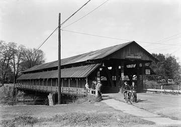
- The Newton Falls Covered Bridge, built in 1831, is the second oldest existing covered bridge in Ohio, the oldest covered bridge in the state still in use on its original site, the only one in Ohio with a covered…
- Newton Falls has one of the most distinctive ZIP codes in the country: 44444.
- The city is named for two sets of waterfalls within the village, each on a different branch of the Mahoning River — and the water plant draws from the East Branch.
- Newton Falls is a wholesaler as well as a retailer: it sells water through a master meter to the Trumbull County Sanitary Engineers' Braceville Township system, and holds emergency-only interconnections with Lordstown…
History4
- 1831The Newton Falls Covered Bridge is built over the Mahoning River — a 123-foot, 24-foot-wide Town lattice truss; a covered walkway was added in 1921-22.
- unknownThe city takes its name from two sets of waterfalls within the village, each on a different branch of the Mahoning River; the water plant's intake sits on the East Branch.
- 2023After the Trumbull County Sanitary Engineers' Braceville Township PWS had a master-meter sample exceed the MCL for HAA5 and/or TTHM, Newton Falls began quarterly disinfection byproduct sampling at…
- 2025UCMR 5 sampling each quarter found PFAS above Ohio EPA revised action levels; the city stated it has added proposed actions and engineering for removal to its capital improvement plan.
Treatment & pressure
How it is treated
Raw water is pumped from the East Branch of the Mahoning River directly to the plant, drawn through an intake on the western bank at the corner of Starr Street and Riverside Drive in Newton Township. Treatment consists of flocculation, two-stage sedimentation, fluoridation, filtration and…
Source: ci.newtonfalls.oh.usci.newtonfalls.oh.usci.newtonfalls.oh.us
Water pressure
Not published. Neither the water treatment page, the water distribution page, nor the 2025 CCR gives system pressure or pressure-zone figures.
Source: ci.newtonfalls.oh.usci.newtonfalls.oh.usci.newtonfalls.oh.us
What it costs
Not published. The city's Utility Billing & Payments page covers billing procedures, payment methods and assistance programs but carries no rate schedule, and a site search…
Source: ci.newtonfalls.oh.us
Water quality & impurities10
| Contaminant | Level | Limit | Year |
|---|---|---|---|
| Total Trihalomethanes (TTHM) Range 33.7-63.7 ppb — about 76% of the MCL, the system's tightest compliance margin. Running annual average basis. | 60.45 ppb | 80 | 2025 |
| Haloacetic Acids (HAA5) Range 6.7-39.1 ppb, running annual average basis. | 37.3 ppb | 60 | 2025 |
| PFOA UCMR 5 entry-point average, range <0.004 to 0.0067 ppb. Equivalent to 4.6 ng/L, above the 4 ng/L federal MCL; the city… | 0.0046 ppb | 0.004 (federal… | 2025 |
| PFOS UCMR 5 entry-point average, range <0.004 to 0.0056 ppb — 4.4 ng/L, above the 4 ng/L federal MCL. | 0.0044 ppb | 0.004 (federal… | 2025 |
| PFBS UCMR 5 entry-point average, range 0.041-0.22 ppb — the largest PFAS detection by concentration. PFBA (0.0086), PFPeA… | 0.098 ppb | none (UCMR 5) | 2025 |
| Nitrate Range 0.10-2.08 ppm; runoff from fertilizer use and leaching from septic tanks or sewage. | 2.08 ppm | 10 | 2025 |
| Fluoride Range 0.83-1.20 ppm; consistent with the plant's published fluoridation step. | 1.05 ppm | 4 | 2025 |
| Lead (90th percentile) Zero of twenty-three samples exceeded the action level. A service line inventory is posted for download on the city… | 0 ppb | 15 (AL) | 2025 |
| Copper (90th percentile) Zero of twenty-three samples exceeded the action level. | 0.093 ppm | 1.3 (AL) | 2025 |
| Barium Discharge of drilling wastes and from metal refineries; erosion of natural deposits. | 0.044 ppm | 2 | 2025 |
Source: ci.newtonfalls.oh.us
EPA compliance record
Lead at the tap: 90th-percentile result 0 ppb in 2025 (action level 15 ppb).
EPA health-based violations since 2015:
- 2017Haloacetic acids (HAA5) · exceeded a maximum contaminant level · measured 0.062 MG/L (limit 0.06 MG/L) · returned to compliance
EPA's count of 2 includes 1 repeat quarterly violation of the problems listed.
Projects & plans1
Planned or needed
- PFAS removal — engineering and proposed actions in the capital improvement plan · 2027 · planned
After UCMR 5 sampling in 2025 found PFAS above Ohio EPA revised action levels, the city states it has included proposed actions and engineering for future…
Source: ci.newtonfalls.oh.us
Supply stress
The 2025 CCR reports that all surface waters are considered susceptible to contamination for source water assessment purposes, and that the Newton Falls protection area is specifically 'highly susceptible' to: agricultural runoff from row crop agriculture; oil and gas wells; failing home and commercial septic systems; spills and releases…
Sewers
Sanitary
Not documented. The city publishes no wastewater treatment plant description, capacity, collection system detail, or sewer rate that could be retrieved from a primary source.
Storm
Not documented in available sources.
Sourcesverified
Compiled from the utility's own reports and public records, then independently re-checked against primary sources.
Main supplier in 1 ZIP code
Serves
Main water supplier in 1 ZIP code
- 44444 · Newton Falls55% of residents
Population-weighted resident shares; a ZIP code can have more than one system on record. Recomputed from each ZIP's own system list, not from the map's cached footprint.
Buys from · Sells to
Newton Falls City does not buy water from another system on record; it treats its own source water.
1 system on record buys water from Newton Falls City: Trumbull Co. - Braceville Twp.
Photograph
On the map
Show this system's territory on the map — 1 ZIP code in all.
Sources
U.S. EPA SDWIS and Community Water System Service Area Boundaries (v3, 2026), Ohio EPA primacy data, 2020 census blocks: the system serving most residents, traced through purchases to the treating utility; Ohio EPA 2023 Sewer and Water Rate Survey (Ohio State, May 2025) for household bills; Ohio EPA DEFA loan awards since 2016 for the loans paragraph · EPA SDWIS · EPA service area boundaries · Ohio EPA drinking water · Ohio EPA rate survey
Newton Falls City's own pages: en.wikipedia.org
Notable facts: en.wikipedia.org, ci.newtonfalls.oh.us
History: en.wikipedia.org, ci.newtonfalls.oh.us
Water quality: ci.newtonfalls.oh.us
Planned work: ci.newtonfalls.oh.us
Water pressure: ci.newtonfalls.oh.us, ci.newtonfalls.oh.us, ci.newtonfalls.oh.us
Rates: ci.newtonfalls.oh.us
Treatment: ci.newtonfalls.oh.us, ci.newtonfalls.oh.us, ci.newtonfalls.oh.us
Supply stress: ci.newtonfalls.oh.us, ci.newtonfalls.oh.us