Local events in Newton Falls
16 events in the next 90 days from 3 public calendars. All local events in Newton Falls
Checked October 20; the events page is refreshed daily.
Lakes near Newton Falls
The history under the water: the valley before, the dam, the stories. All Ohio lakes
How Newton Falls began
Newton Falls takes its name directly from its site, at falls on two branches of the Mahoning River within Newton Township, itself likely named for settlers from Newtown, Connecticut. The village grew slowly through the 1800s into a modest population of 575 by 1880, then boomed through the early 1900s steel economy to a peak of 5,378 residents in 1970. Its best-known landmark, the Newton Falls Covered Bridge, was built around 1831 and remains the second-oldest covered bridge in Ohio and the only one in the state with its own covered pedestrian walkway. On May 31, 1985, Newton Falls was struck by the only F5 tornado recorded in Ohio that day, part of the wider 1985 United States-Canada tornado outbreak, destroying homes and leaving 400 families homeless.
Where the name comes from
Newton Falls takes its name from its location at falls on two separate branches of the Mahoning River, within Newton Township -- itself likely named for settlers who had come from Newtown, Connecticut.
Before the town
No Native village, camp or treaty event specific to the Newton Falls town site is recorded in the sources we reviewed. The falls on the Mahoning River at this location would plausibly have drawn Native travelers and fishers in the same way river falls elsewhere in the Reserve did, but no source found documents such use here specifically. The site lies within the valley the county's 1882 history describes as Delaware-occupied hunting ground used seasonally by Seneca and Mingo bands through the 1700s.
Nations recorded here: Lenape (Delaware), Seneca, Mingo (Seneca-Cayuga).
Timeline
- — The Newton Falls Covered Bridge is built across the east branch of the Mahoning River; it remains the second-oldest existing covered bridge in Ohio and the oldest still in use on its original site.
- — Newton Falls has 575 residents.
- — A pedestrian walkway is added to the covered bridge for children walking to the school on Center Street, making it the only covered bridge in Ohio with its own covered crosswalk.
- — Newton Falls's population reaches 3,458, a 214.4 percent increase reflecting the village's early-20th-century steel-industry boom.
- — Historic American Buildings Survey photographer Carl Waite documents the Newton Falls Covered Bridge for the Library of Congress.
- — Newton Falls's population peaks at 5,378.
- — The Newton Falls Covered Bridge is listed on the National Register of Historic Places.
- — An F5 tornado, the only F5 recorded in Ohio that day, devastates downtown Newton Falls, injuring 70 to 80 people and leaving 400 families homeless.
- — A monument memorializing the 1985 tornado is dedicated at Broad and Center Streets.
Stories
The bridge with its own sidewalk
The Newton Falls Covered Bridge, raised around 1831 across the east branch of the Mahoning River, is unusual even among Ohio's dwindling stock of covered bridges: it is the second-oldest still standing in the state and the oldest still in use on the exact site it was built on, a three-span timber truss with vertical board siding that Trumbull County has kept in continuous service for nearly two centuries. Its most distinctive feature came later -- in 1921, as automobile traffic grew heavier on the bridge, the county added a separate covered pedestrian walkway so children could cross safely on their way to the school on Center Street, a small addition that makes it the only covered bridge anywhere in Ohio with its own covered crosswalk. The bridge survived long enough to be documented by the federal Historic American Buildings Survey in October 1936 and listed on the National Register of Historic Places in 1974, and remains the last surviving covered bridge in Trumbull County.
The only F5 that day
On May 31, 1985, during a violent tornado outbreak that struck Ohio, Pennsylvania, New York and Ontario in a single afternoon, Newton Falls was hit by an F5 tornado -- the most powerful rating on the scale, and the only F5 recorded anywhere in Ohio that day. The storm tore through downtown, injuring seventy to eighty people and leaving some four hundred families homeless in a village whose entire population numbered only a few thousand, a disaster proportionally enormous for a small Trumbull County community. It took decades for the village to memorialize the event formally: a monument to the tornado was not dedicated at Broad and Center Streets until 2022, nearly four decades after the storm, giving Newton Falls residents a fixed place to mark what remains the most destructive single day in the village's modern history.
Photographs
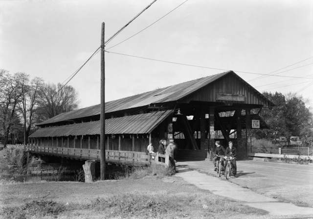
Photo: Carl Waite, Library of Congress Prints & Photographs Division (Historic American Buildings Survey), public domain · Wikimedia Commons
Local history sources: en.wikipedia.org · en.wikipedia.org · archive.org · commons.wikimedia.org
Historic places
2 places in Newton Falls on the National Register of Historic Places. Press a pin or a name for its whole record.
-
Newton Falls Covered BridgeStructure · Newton Falls · listed 1974
- Address
- Off OH 534
- Where
- Newton Falls, Trumbull County · ZIP 44444
- What it is
- Structure
- Listed on the National Register
- 1974
- NRIS reference number
- 74001636
- Coordinates
- 41.18801, -80.97131
National Register file (NPS) ↗ Search Wikipedia ↗ Street map and directions ↗ On the Cracked Buckeye map
-
Newton Falls United Service Organization (USO) CenterBuilding · Newton Falls
- Address
- 52 E Quarry St.
- Where
- Newton Falls, Trumbull County · ZIP 44444
- What it is
- Building
- Latest NPS certification action
- 2018
- NRIS reference number
- 100002124
- Coordinates
- 41.18349, -80.97543
National Register file (NPS) ↗ Search Wikipedia ↗ Street map and directions ↗ On the Cracked Buckeye map
Source: National Park Service, National Register of Historic Places point file. The listing year is shown where NPS's certification date agrees with the listing's reference number. Listing recognizes significance; it does not restrict a private owner.
Water
East Branch Mahoning River The water here
- Newton Falls City97% of residentsEast Branch Mahoning River
- Trumbull Co. - Braceville Twp3% of residentsEast Branch Mahoning River
Hospitals, fire stations and more
Inside Newton Falls's boundary: 1 health center, 1 fire or EMS station, 4 public schools, 1 poor-rated bridge, 1 library, 1 police station, 1 Toxics Release Inventory facility and 2 spill cases. Press a pin or a name for its whole record and its source.
Community health centers (1)
-
Newton Falls Community Health CenterHealth center · Newton Falls
- Run by
- a federally qualified health center
- Setting
- Clinic
- City
- Newton Falls
- Coordinates
- 41.18676, -80.97092
Find a Health Center (HRSA) ↗ HRSA data (source) ↗ Street map and directions ↗
Source: HRSA health center service delivery sites, active, September 2026 (school-based sites left out). Health centers see patients whether or not they have insurance, with fees on a sliding scale.
Fire and EMS stations (1)
-
Newton Falls Joint Fire DistrictNewton Falls
- Address
- 19 North Canal Street, Newton Falls, OH 44444
- Coordinates
- 41.18886, -80.97712
USGS National Map structures (source) ↗ Street map and directions ↗
Source: USGS National Map structures (most Ohio records last updated 2019 to 2022), checked against the Columbus and Cleveland station lists. The department that answers a call is set by jurisdiction and mutual aid, not by distance.
Public schools (4)
-
Newton Falls Elementary School4 of 5 stars · Newton Falls
- Address
- 905 Milton Blvd, Newton Falls, OH 44444
- School district
- Newton Falls Ex Vill School District
- Kind (NCES)
- Regular School
- Students, 2023-24
- 228
- Teachers (full-time equivalent)
- 14.99
- Report card, 2025-26
- 4 of 5 stars
- Performance index
- 85.1%
- Ohio building IRN
- 000950
- NCES school ID
- 390455602279
NCES school record ↗ Ohio School Report Card ↗ Street map and directions ↗
-
Newton Falls High School4 of 5 stars · Newton Falls
- Address
- 907 Milton Blvd, Newton Falls, OH 44444
- School district
- Newton Falls Ex Vill School District
- Kind (NCES)
- Regular School
- Students, 2023-24
- 259
- Teachers (full-time equivalent)
- 16.37
- Report card, 2025-26
- 4 of 5 stars
- Performance index
- 68.4%
- Four-year graduation rate
- 93.8%
- Ohio building IRN
- 027151
- NCES school ID
- 390455602281
NCES school record ↗ Ohio School Report Card ↗ Street map and directions ↗
-
Newton Falls Junior High School2.5 of 5 stars · Newton Falls
- Address
- 907 1/2 Milton Blvd, Newton Falls, OH 44444
- School district
- Newton Falls Ex Vill School District
- Kind (NCES)
- Regular School
- Students, 2023-24
- 224
- Teachers (full-time equivalent)
- 15.05
- Report card, 2025-26
- 2.5 of 5 stars
- Performance index
- 65%
- Ohio building IRN
- 064725
- NCES school ID
- 390455602282
NCES school record ↗ Ohio School Report Card ↗ Street map and directions ↗
-
Newton Falls Middle School3 of 5 stars · Newton Falls
- Address
- 905 Milton Blvd, Newton Falls, OH 44444
- School district
- Newton Falls Ex Vill School District
- Kind (NCES)
- Regular School
- Students, 2023-24
- 133
- Teachers (full-time equivalent)
- 6.01
- Report card, 2025-26
- 3 of 5 stars
- Performance index
- 69.8%
- Ohio building IRN
- 005256
- NCES school ID
- 390455602280
NCES school record ↗ Ohio School Report Card ↗ Street map and directions ↗
Source: NCES EDGE public school locations 2024-25 and Common Core of Data 2023-24 (type, students, teachers); Ohio School Report Cards 2025-26 (Department of Education and Workforce), matched by name within the district.
Bridges rated poor (1)
-
I80 Oh Tpk over Csx RrPoor · built 1956
- Condition
- Poor: a deck, superstructure, substructure or culvert rated 4 or below on the 0 to 9 scale
- What it is
- Bridge
- Built
- 1956
- Length
- 51 ft
- Owner
- Other
- Vehicles a day
- 35,398
- Coordinates
- 41.20315, -80.94735
National Bridge Inventory (source) ↗ Street map and directions ↗
Source: FHWA National Bridge Inventory 2025. "Poor" means one major part rated 4 or below on the 0 to 9 scale; it calls for repair, not closing, unless the state posts or closes the bridge.
Public libraries (1)
-
Newton Falls Public LibraryCentral library · Newton Falls
- Address
- 204 S. Canal St., Newton Falls, OH 44444
- What it is
- Central library
- Library system
- Newton Falls Public Library
- Open
- 2,964 hours a year, 52 weeks
- Building
- 13,750 sq ft
- System's visits, FY2024
- 35,828
- System's loans, FY2024
- 97,424
- People the system serves
- 8,504
- Phone
- (330) 872-1282
IMLS Public Libraries Survey (source) ↗ Street map and directions ↗
Source: IMLS Public Libraries Survey FY2024 (outlets and their systems). Any Ohio resident can get a free card at any Ohio public library.
Police stations (1)
-
Newton Falls Police DepartmentNewton Falls
- Address
- 19 North Canal Street, Newton Falls, OH 44444
- Coordinates
- 41.18888, -80.97694
USGS National Map structures (source) ↗ Street map and directions ↗
Source: USGS National Map structures, police stations, corrected and completed by hand (September 2026). The department that answers a call is set by jurisdiction, not by distance.
Facilities reporting toxic releases (1)
-
Transco Railway Products, Inc. (0278050669)Toxics Release Inventory · Newton Falls
- Address
- 2310 S Center St, Newton Falls, OH 44444
- County
- Trumbull County
- Status
- Reports to the Toxics Release Inventory (***unchanged***)
- EPA program ID
- 4444WTRNSC231SC
- EPA registry ID
- 110004633013
EPA facility record ↗ EPA Facility Registry Service (source) ↗ Street map and directions ↗
Source: EPA Facility Registry Service, Toxics Release Inventory reporters. Reporting a release is required of large users of listed chemicals; it is not by itself a violation.
Spills reported since 2021 (2)
-
Sheen Rainbow / Hydrocarbon2024-06-17 · Newton Falls
- Reported
- 2024-06-17
- What spilled
- Sheen Rainbow / Hydrocarbon
- Where
- Newton Falls, Trumbull County
- Ohio EPA district office
- NEDO
- Ohio EPA case number
- 2406EPA0001023
Ohio EPA spill reports (source) ↗ Street map and directions ↗
-
Fuel Diesel / Diesel Fuel (Vehicle On Or Off Road)2022-07-14 · Newton Falls
- Reported
- 2022-07-14
- What spilled
- Fuel Diesel / Diesel Fuel (Vehicle On Or Off Road)
- Largest amount reported
- 70 gallons
- Where
- Newton Falls, Trumbull County
- Ohio EPA district office
- NEDO
- Ohio EPA case number
- 2207EPA0001063
Ohio EPA spill reports (source) ↗ Street map and directions ↗
Source: Ohio EPA emergency response spill reports, 2021 to September 2026, one point per case where Ohio EPA placed it. A report is what the caller or responder recorded; amounts are often blank or estimated.
Its ZIP codes
Each ZIP code that touches Newton Falls, with the share of its residents who live here and the same headline figures as the ZIP page.
| ZIP | Share | Water | Radon | Home value | Schools | Flood |
|---|---|---|---|---|---|---|
| 44444 Newton Falls | 46% | East Branch Mahoning River | 3.1 pCi/L average radon | Median year built 1953 | Newton Falls Exempted Village · 3.5 stars overall | 3.7% of residents in the 1% floodplain |
Local government
Who holds office in Newton Falls, how its elections and ballot issues came out, and the state auditor's record.
Who holds office
| Office | Name | Party | Term ends | Contact |
|---|---|---|---|---|
| Mayor | DAVID NILES HANSON | 12/31/2027 | P.O. BOX 65, NEWTON FALLS, OH 44444 | |
| Council At Large | JULIE A. STIMPERT | 12/31/2029 | 1023 PAIGE CT, NEWTON FALLS, OH 44444 | |
| Member of Council (1St Ward) | BRIAN KROPP | 12/31/2029 | 247 ELIZABETH ST, NEWTON FALLS, OH 44444 | |
| Member of Council (2Nd Ward) | BRIAN AXITOIS | Democratic | 12/31/2027 | 315 ADAMS ST, NEWTON FALLS, OH 44444 |
| Member of Council (4Th Ward) | KEVIN RUFENER | 12/31/2027 | 518 S CANAL ST, NEWTON FALLS, OH 44444 |
Roster as of 2026-08-24: county board of elections.
Money issues on the ballot since 2015: 4 of 10 passed; of those asking for new or higher taxes, 0 of 2.
Ballot issues
| Date | Issue | For | Against | Result |
|---|---|---|---|---|
| 2024-11-05 | Issue: Newton Falls Referendum on Historic Sites & Structures | 788 | 909 | Failed (46.43% for), unofficial |
| 2023-11-07 | Issue: Newton Falls Village Spletzer Recall | 73 | 271 | Failed (21.22% for) |
| 2023-11-07 | Issue: Newton Falls Proposed Charter Amendment 09-2023 | 836 | 401 | Passed (67.58% for) |
| 2023-11-07 | Issue: Newton Falls Proposed Charter Amendment 10-2023 | 861 | 378 | Passed (69.49% for) |
| 2023-11-07 | Issue: Newton Falls Proposed Charter Amendment 11-2023 | 707 | 535 | Passed (56.92% for) |
| 2023-11-07 | Issue: Newton Falls Proposed Charter Amendment 12-2023 | 909 | 324 | Passed (73.72% for) |
| 2023-11-07 | Issue: Newton Falls Proposed Charter Amendment 13-2023 | 989 | 247 | Passed (80.02% for) |
| 2023-11-07 | Issue: Newton Falls Proposed Charter Amendment 14-2023 | 789 | 423 | Passed (65.1% for) |
| 2023-11-07 | Issue: Newton Falls Proposed Charter Amendment 15-2023 | 867 | 349 | Passed (71.3% for) |
| 2023-11-07 | Issue: Newton Falls Proposed Charter Amendment 16-2023 | 729 | 484 | Passed (60.1% for) |
| 2023-11-07 | Issue: Newton Falls Proposed Charter Amendment 17-2023 | 971 | 250 | Passed (79.52% for) |
| 2023-11-07 | Issue: Newton Falls Proposed Charter Amendment 18-2023 | 998 | 223 | Passed (81.74% for) |
| 2023-11-07 | Issue: Newton Falls Proposed Charter Amendment 19-2023 | 685 | 421 | Passed (61.93% for) |
| 2023-11-07 | Issue: Newton Falls Proposed Charter Amendment 20-2023 | 772 | 395 | Passed (66.15% for) |
| 2023-11-07 | Issue: Newton Falls Proposed Charter Amendment 21-2023 | 761 | 441 | Passed (63.31% for) |
| 2023-11-07 | Issue: Newton Falls Proposed Charter Amendment 22-2023 | 734 | 451 | Passed (61.94% for) |
| 2023-11-07 | Issue: Newton Falls Proposed Charter Amendment 23-2023 | 929 | 268 | Passed (77.61% for) |
| 2023-11-07 | Issue: Newton Falls Proposed Charter Amendment 24-2023 | 718 | 450 | Passed (61.47% for) |
| 2023-11-07 | Issue: Newton Falls Proposed Charter Amendment 28-2023 | 567 | 627 | Failed (47.49% for) |
| 2023-11-07 | Issue: Newton Falls Proposed Municipal Income Tax Police | 478 | 798 | Failed (37.46% for) |
| 2023-11-07 | Issue: Newton Falls Proposed Municipal Income Tax Roads | 521 | 760 | Failed (40.67% for) |
| 2022-11-08 | Issue: Newton Falls Village Police Additional 4 mills 5 years (4.0 mills, additional) | 472 | 911 | Failed (34.13% for) |
| 2022-11-08 | Issue: Newton Falls Village Charter Amendment 23-2022 | 496 | 886 | Failed (35.89% for) |
| 2022-11-08 | Issue: Newton Falls Village Charter Amendment 24-2022 | 772 | 585 | Passed (56.89% for) |
| 2022-11-08 | Issue: Newton Falls Village Charter Amendment 25-2022 | 583 | 756 | Failed (43.54% for) |
Elections for office
| Date | Office | Candidates and votes |
|---|---|---|
| 2025-11-04 | Village Council at Large | John R. Baryak 144, 19.07%; Julie Stimpert 611, 80.93% |
| 2025-11-04 | Village Council (3rd Ward) | No Valid Petition Filed 0 |
| 2025-11-04 | Village Council (1st Ward) | Brian Kropp 126, 100.0% |
| 2025-05-06 | Village Council at Large (Nonpartisan primary) | John R. Baryak 53, 19.2%; Julie Stimpert 223, 80.8% |
| 2025-05-06 | Village 3rd Ward Council (Nonpartisan primary) | No Valid Petition Filed 0 |
| 2025-05-06 | Village 1st Ward Council (Nonpartisan primary) | Brian Kropp 50, 50.0%; Julie A. Lemon 50, 50.0% |
| 2023-11-07 | Village Mayor | David Nils Hanson 911, 100.0% |
| 2023-11-07 | Village Council (4th Ward) | Kevin R. Rufener 274, 100.0% |
| 2023-11-07 | Village Council (2nd Ward) | Brian Axiotis 136, 56.9%; Condie Bright 103, 43.1% |
| 2023-11-07 | Village Council (1st Ward) UTE | Patricia Benetis 258, 72.88%; Michael L. Kren 96, 27.12% |
| 2023-05-02 | Village Mayor (Nonpartisan primary) | David Nils Hanson 227, 53.66%; Kenneth A. Kline 196, 46.34% |
| 2023-05-02 | Village Council 4th Ward (Nonpartisan primary) | Kevin R. Rufener 76, 100.0% |
| 2023-05-02 | Village Council 2nd Ward (Nonpartisan primary) | Brian Axiotis 45, 40.54%; Condie Bright 36, 32.43%; Tracy Hurst 30, 27.03% |
| 2023-05-02 | Village Council 1st Ward UTE 12-31-2025 (Nonpartisan primary) | Patricia Benetis 66, 43.42%; Michael L. Kren 41, 26.97%; Julie A. Lemon 31, 20.39%; Jaime Kline 14, 9.21% |
| 2022-05-03 | 4th Ward Council | Christopher V. Granchie 112, 100.0% |
| 2021-11-02 | Village Council at Large | Brian Kropp 227, 35.03%; Julie A. Stimpert 421, 64.97% |
| 2021-11-02 | Village 3rd Ward Council | Charles Homa 90, 45.92%; Tesa Spletzer 106, 54.08% |
| 2021-11-02 | Village 1st Ward Council | Michael A. Serotko 161, 75.94%; Adam Zimmermann 51, 24.06% |
| 2020-11-03 | 3rd Ward Council | Tesa Spletzer 385, 67.31%; Lyle A. Waddell 187, 32.69% |
| 2020-03-17 | 3rd Ward Council | Dougle Hankins 24, 10.71%; Tesa Spletzer 109, 48.66%; Lyle A. Waddell 91, 40.62% |
| 2019-11-06 | Village Mayor | Kenneth A. Kline 580, 53.11%; Richard Monteville 512, 46.89% |
| 2019-11-06 | Village 4th Ward Council | Sandra Breymaier 155, 62.0%; Catie Karl 95, 38.0% |
| 2019-11-06 | Village 2nd Ward Council | John R. Baryak, Jr. 155, 71.1%; Nancy H. Hoffman 63, 28.9% |
| 2019-11-06 | Village 2nd Ward Council | Nancy H. Hoffman 75, 100.0% |
| 2017-11-07 | Council at Large (number of seats not on file, so winners are not marked) | Alberini, Tarry 483, 55.77%; Layshock, Patrick D. 332, 38.34%; Write-in Votes 51, 5.89% |
Winners in bold. Results from the county board of elections' official canvass unless marked.
Auditor of State record
- No fiscal caution, watch or emergency on the Auditor of State's lists.
- Financial Audit, 2021 to 2022, released 2025-08-07
The county
Trumbull County: 25 ZIP codes, 32 cities, villages and townships, 194,818 people.
Nearby places
Rain and snow
How much has actually fallen on Newton Falls, day by day, from 1893 to now. Daily totals, not averages.
- rain, last 30 days
- 1.07 in
- 2026-09-30 to 2026-10-29
- rain so far in 2026
- 38.3 in
- 2.6 in above normal for the date
- snow so far in 2026
- 34.6 in
- a normal year brings 49.5 in
- a normal year
- 41.9 in
- average of 30 years, 1991-2020
| Month | Rain (in) | Snow (in) | Days counted |
|---|---|---|---|
| October 2026 | 1.07 | — | 29 |
| September 2026 | 4.43 | — | 30 |
| August 2026 | 4.60 | — | 31 |
| July 2026 | 5.41 | — | 31 |
| June 2026 | 2.33 | — | 30 |
| May 2026 | 5.17 | — | 31 |
| April 2026 | 7.74 | — | 30 |
| March 2026 | 4.63 | 2.3 | 31 |
| February 2026 | 0.65 | 7.2 | 28 |
| January 2026 | 2.29 | 25.2 | 31 |
| December 2025 | 2.52 | 17.3 | 31 |
| November 2025 | 1.67 | 11.0 | 30 |
| Wettest year | 2011 — 57.2 in |
|---|---|
| Driest year | 1963 — 24.3 in |
| Snowiest year | 1910 — 107.9 in |
| Wettest day on record | 9 August 2013 — 3.75 in |
| Heaviest snowfall in a day | 20 April 1901 — 19.27 in |
| Deepest snow on the ground | 26 November 1950 — 20.67 in |
Mostly estimated. Only 12% of these days come from a gauge standing inside Newton Falls - the rest are worked out from the nearest gauges around it, so read them as close estimates rather than readings.
48,869 days of records, 1893-01-01 to 2026-10-29. Source: NOAA NCEI GHCN-Daily, 3,240 gauges in and around Ohio. A day is "gauged" when a gauge standing inside the boundary reported it, and the value is the mean of those gauges. Otherwise it is interpolated by inverse distance from every gauge reporting within 50 miles. Nothing is carried forward, back-filled or smoothed. Against NOAA nClimDiv county monthly precipitation over 136,848 complete county-months (checked 2026-10-31): correlation 0.9515, median absolute difference 0.217 in a month. Built 2026-10-31 from the Cracked Buckeye precipitation archive. Snow is the softer number — snowfall is measured by hand with a ruler, no agency publishes a gridded county snowfall series, and blowing snow defeats every observer.
Environmental permits and filings
What Ohio EPA has on file for Newton Falls: permits, inspections, violations, cleanups and the state loans behind sewer and water work. Every line links to the agency's own document.
- facilities and sites on file
- 9
- those placed on the map inside Newton Falls
| Program | Facilities and sites |
|---|---|
| Hazardous waste | 4 |
| Wastewater and stormwater discharge | 2 |
| Air pollution | 1 |
| Brownfield | 1 |
| Public drinking water | 1 |
| Date | Facility or site | What |
|---|---|---|
| EVERGREEN BATTERY RECYCLING LLC | Air pollution report | |
| PIR 3941 - NORTH CANAL AND WEST BROAD | Wastewater and stormwater discharge permit | |
| NEWTON FALLS CITY PWS | Public drinking water report | |
| NEWTON FALLS CITY PWS | Public drinking water violation resolved | |
| NEWTON FALLS CITY PWS | Public drinking water plan | |
| CIRCLE K NEWTON FALLS OH (WEST BROAD ST) | Wastewater and stormwater discharge permit | |
| NEWTON FALLS CITY PWS | Public drinking water inspection | |
| NEWTON FALLS CITY PWS | Public drinking water inspection | |
| NEWTON FALLS CITY PWS | Public drinking water letter | |
| NEWTON FALLS CITY PWS | Public drinking water inspection | |
| NEWTON FALLS CITY PWS | Public drinking water inspection | |
| NEWTON FALLS CITY PWS | Public drinking water inspection | |
| KODU INC, FORMER | Brownfield assessment | |
| NEWTON FALLS CITY PWS | Public drinking water notice of violation | |
| PIR 3941 - NORTH CANAL AND WEST BROAD | Wastewater and stormwater discharge permit | |
| NEWTON FALLS CITY PWS | Public drinking water plan | |
| EVERGREEN BATTERY RECYCLING LLC | Hazardous waste inspection | |
| NEWTON FALLS CITY PWS | Public drinking water compliance letter | |
| KODU INC, FORMER | Brownfield assessment | |
| NEWTON FALLS CITY PWS | Public drinking water report | |
| NEWTON FALLS CITY PWS | Public drinking water plan | |
| KODU INC, FORMER | Brownfield assessment | |
| NEWTON FALLS CITY PWS | Public drinking water inspection | |
| EVERGREEN BATTERY RECYCLING LLC | Air pollution inspection | |
| NEWTON FALLS CITY PWS | Public drinking water notice of violation |
Source: Ohio EPA eDocument portal (edocpub.epa.ohio.gov), indexed 2026-10-14. Facilities are placed on the map from Ohio EPA's own map layers, EPA's Facility Registry, coordinates written in the filings, or a geocoded street address. A permit filed under a private person's name (most are household septic systems) is counted but never named, placed or linked; licenses for individual workers and open-burning notices are left out entirely.
Quick answers
What county is Newton Falls, Ohio in?
Newton Falls is a village in Trumbull County, Ohio, with 4,600 residents.
How did Newton Falls, Ohio get its name?
Newton Falls takes its name from its location at falls on two separate branches of the Mahoning River, within Newton Township -- itself likely named for settlers who had come from Newtown, Connecticut. Source
What ZIP code is Newton Falls, Ohio?
Most of Newton Falls is in ZIP code 44444.
Where does Newton Falls, Ohio get its water?
The main water source for Newton Falls (Newton Falls City): East Branch Mahoning River.
Cite this page
Cite this page as:
Cracked Buckeye, "Newton Falls, Trumbull County", https://crackedbuckeye.com/place/newton-falls/, built 2026-10-31, accessed [date].
How to cite · Report a correction · Built 2026-10-31
