Local events in Maumee
48 events in the next 90 days from 5 public calendars. All local events in Maumee
Checked October 20; the events page is refreshed daily.
Lakes near Maumee
The history under the water: the valley before, the dam, the stories. All Ohio lakes
Deep dives about Maumee
Long reads built from maps, newspapers and public records. All deep dives
- Fallen Timbers BattlefieldOn August 20, 1794, Anthony Wayne's Legion routed a Native confederacy in storm-felled timber near Maumee, a defeat that led to the 1795 Treaty of Greenville.
- Ohio's Road to StatehoodFrom the French and Indian War through St. Clair's defeat to a one-vote loss of Black suffrage, Ohio's path to statehood in 1803 was neither clean nor certain.
- The Toledo WarThe 1835-36 Ohio-Michigan boundary dispute over the Toledo Strip: a bad map, a 3 a.m. court, one stabbing, no deaths, and the Upper Peninsula trade.
- Toledo and PerrysburgNearly tied at 1,222 and 1,041 people in 1840, two Maumee River towns split into a glass-making city and a growing suburb. How it happened, from Fallen Timbers to 2020.
Notable people from Maumee
Ohioans tied to this place, each with a sourced profile. All notable Ohioans
History from Maumee
People and inventions tied to this place, each with its sources. All people · All inventions
How Maumee began
Maumee sits at the foot of the Maumee Rapids where the British-built Fort Miamis stood in 1794, the fort whose commander famously barred its gates against defeated Native warriors fleeing the Battle of Fallen Timbers, fought just outside its walls. A town plat went down there in 1817, and for decades Maumee competed hard with its downriver rival Toledo -- serving as county seat of a much larger Lucas County until it lost the honor to Toledo in 1854 -- before the Miami and Erie Canal and later the railroads settled the contest. The city's oldest streets still carry an unusual concentration of standing 1830s and 1840s buildings, among them the House of Four Pillars and the Governor's Inn, both raised in the canal-boom years when speculators believed Maumee, not Toledo, would become the great city of the Maumee valley.
Platted 1817, 'at the Foot of the Rapids of the Maumee River'.
Where the name comes from
Maumee takes its name from the Maumee River, itself an anglicized form of the Myaamia (Miami) people's name; the river and the town's site were long a Miami and, by the eighteenth century, an Odawa (Ottawa) travel corridor between Lake Erie and the interior.
Before the town
Maumee sits at the foot of the Maumee Rapids, a stretch of the river that was a crossing point and travel corridor for the Odawa (Ottawa), Wyandot, Shawnee, Lenape (Delaware), Potawatomi and Ojibwe through the eighteenth century. General Anthony Wayne's American army fought and defeated an allied Native and Canadian-militia force at the Battle of Fallen Timbers on August 20, 1794, in what is now the southwestern part of the city; the defeated warriors fled toward the British-held Fort Miamis on the riverbank, but its commander, Major William Campbell, refused to open the gates rather than risk war with the United States, and the battle's survivors were left to retreat further. The British reoccupied Fort Miamis during the War of 1812, using it as a headquarters, with Tecumseh present, for operations against the American-held Fort Meigs on the river's opposite (Wood County) bank. After the war, the September 29, 1817 Treaty of the Maumee Rapids -- commonly called the Treaty of Fort Meigs, for the fort across the river rather than any structure in Maumee itself -- ceded roughly 4.6 million acres of northwestern Ohio to the United States.
Nations recorded here: Odawa (Ottawa), Wyandot, Shawnee, Miami.
- Battle of Fallen Timbers battlefield (battle) — southwestern Maumee, bounded roughly by I-475, US 24, Jerome Road and the railroad right-of-way, August 20, 1794 (en.wikipedia.org)
- Fort Miamis (Fort Miami) (other) — on the Maumee River within present Maumee, built spring 1794 by the British; reoccupied in the War of 1812; abandoned 1814 (en.wikipedia.org)
Timeline
- — General Anthony Wayne defeats an allied Native and Canadian-militia force at the Battle of Fallen Timbers, in what is now southwestern Maumee; the retreating warriors are refused shelter at the nearby British Fort Miamis.
- — The Treaty of the Maumee Rapids (Fort Meigs) is signed nearby, ceding roughly 4.6 million acres of northwestern Ohio to the United States.
- — A town plat is laid out at the Foot of the Rapids of the Maumee River, founding Maumee.
- — The house later known as the House of Four Pillars is built at 322 East Broadway.
- — Levi Beebe builds the Commercial Building on River Road, later known as the Governor's Inn, first as a store and post office, then as a canal and stagecoach lodge after the Miami and Erie Canal opens.
- — The Wabash and Erie Canal extension is completed, and town promoter Jessup Scott predicts Maumee will become 'the great city of the West.'
- — Itinerant column workers, likely the same craftsmen who worked on the Lucas County Courthouse, add four Doric columns to the 1835 house, giving it the name House of Four Pillars.
- — Maumee loses the Lucas County seat to Toledo.
- — The Governor's Inn is added to the National Register of Historic Places, the fifth Maumee property to be so listed.
Stories
The gates that stayed shut
When General Anthony Wayne's American army broke a Native and Canadian-militia line among the wind-felled trees south of Fort Miamis on August 20, 1794, the defeated warriors did what beaten armies with a friendly fort nearby usually do: they ran for its gates. The fort's British commander, Major William Campbell, refused to let them in. Britain and the United States were not at war, and opening the fort to shelter combatants who had just fought American troops risked starting one Campbell had no orders to start; so the gates stayed shut, and the warriors who had counted on British protection had to keep running past the walls that were supposed to save them. The decision effectively ended the Northwest Indian War in the United States' favor and, a year later, produced the Treaty of Greenville. Fort Miamis itself lasted only another twenty years, reoccupied briefly by the British in the War of 1812 as a headquarters near their siege of the American-held Fort Meigs across the river, then abandoned in 1814; today only earthworks remain, preserved with the battlefield as a National Historic Site jointly run by the National Park Service, Metroparks Toledo and the Ohio History Connection.
A house built for a president's guardian
The house at 322 East Broadway went up plain in 1835, but its early owners were anything but: John E. Hunt, an early Lucas County treasurer and state legislator; James M. Spafford, brother of Perrysburg's founder; and Sardis Birchard, a Maumee merchant and banker who had taken in and raised his orphaned nephew, Rutherford B. Hayes, the future nineteenth president. It was most likely Birchard who, around 1844, hired itinerant 'column workers' -- craftsmen who traveled town to town fitting custom Doric columns for a fee, probably the same crew then working the new Lucas County Courthouse -- to dress the house in four full-height columns, earning it the name House of Four Pillars. Local tradition holds that a tunnel from the basement to a ravine above the Maumee River once sheltered freedom seekers on the Underground Railroad, though as with much oral history the physical evidence has not survived to confirm it. The house's best-documented literary claim is firmer: novelist Theodore Dreiser reportedly wrote the opening chapters of Sister Carrie there in the 1890s, while it was briefly owned by Toledo Blade editor Arthur Henry and his wife Maude, one of the era's few woman reporters.
Photographs
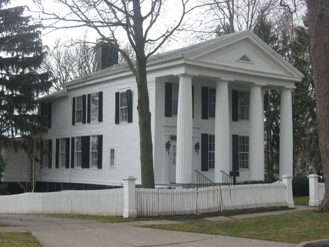
Photo: Nyttend, public domain · Wikimedia Commons
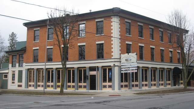
Photo: Nyttend, public domain · Wikimedia Commons
Local history sources: en.wikipedia.org · en.wikipedia.org · en.wikipedia.org · en.wikipedia.org · holytoledohistory.com · en.wikipedia.org · commons.wikimedia.org · commons.wikimedia.org
Historic places
11 places in Maumee on the National Register of Historic Places. Press a pin or a name for its whole record.
-
Eckenrode And Breisach HousesBuilding · Maumee · listed 1978
- Address
- 202 and 204 E. Dudley St.
- Where
- Maumee, Lucas County · ZIP 43537
- What it is
- Building
- Listed on the National Register
- 1978
- NRIS reference number
- 78002120
- Coordinates
- 41.56340, -83.65154
National Register file (NPS) ↗ Search Wikipedia ↗ Street map and directions ↗ On the Cracked Buckeye map
-
First Presbyterian Church Of Maumee ChapelBuilding · Maumee · listed 1973
- Address
- 200 E. Broadway
- Where
- Maumee, Lucas County · ZIP 43537
- What it is
- Building
- Listed on the National Register
- 1973
- NRIS reference number
- 73001498
- Coordinates
- 41.56153, -83.65050
National Register file (NPS) ↗ Search Wikipedia ↗ Street map and directions ↗ On the Cracked Buckeye map
-
Forsythe--Puhl HouseBuilding · Maumee · listed 1989
- Address
- 106 E. Harrison Ave.
- Where
- Maumee, Lucas County · ZIP 43537
- What it is
- Building
- Listed on the National Register
- 1989
- NRIS reference number
- 89000429
- Coordinates
- 41.55996, -83.65212
National Register file (NPS) ↗ Search Wikipedia ↗ Street map and directions ↗ On the Cracked Buckeye map
-
Governor's InnBuilding · Maumee · listed 1974
- Address
- 301 River Rd.
- Where
- Maumee, Lucas County · ZIP 43537
- What it is
- Building
- Listed on the National Register
- 1974
- NRIS reference number
- 74001557
- Coordinates
- 41.56443, -83.64595
National Register file (NPS) ↗ Search Wikipedia ↗ Street map and directions ↗ On the Cracked Buckeye map
-
Griswold, Peck, HouseBuilding · Maumee · listed 1978
- Address
- 228 E. Broadway
- Where
- Maumee, Lucas County · ZIP 43537
- What it is
- Building
- Listed on the National Register
- 1978
- NRIS reference number
- 78002121
- Coordinates
- 41.56277, -83.64756
National Register file (NPS) ↗ Search Wikipedia ↗ Street map and directions ↗ On the Cracked Buckeye map
-
Hanson HouseBuilding · Maumee · listed 1978
- Address
- 405 E. Broadway
- Where
- Maumee, Lucas County · ZIP 43537
- What it is
- Building
- Listed on the National Register
- 1978
- NRIS reference number
- 78002122
- Coordinates
- 41.56163, -83.65015
National Register file (NPS) ↗ Search Wikipedia ↗ Street map and directions ↗ On the Cracked Buckeye map
-
House Of Four PillarsBuilding · Maumee · listed 1973
- Address
- 322 E. Broadway
- Where
- Maumee, Lucas County · ZIP 43537
- What it is
- Building
- Listed on the National Register
- 1973
- NRIS reference number
- 73001499
- Coordinates
- 41.56185, -83.65999
National Register file (NPS) ↗ Search Wikipedia ↗ Street map and directions ↗ On the Cracked Buckeye map
-
Hull, Isaac, StoreBuilding · Maumee · listed 1978
- Address
- 114 E. Harrison St.
- Where
- Maumee, Lucas County · ZIP 43537
- What it is
- Building
- Listed on the National Register
- 1978
- NRIS reference number
- 78002123
- Coordinates
- 41.56026, -83.65093
National Register file (NPS) ↗ Search Wikipedia ↗ Street map and directions ↗ On the Cracked Buckeye map
-
Hull-Wolcott HouseBuilding · Maumee · listed 1970
- Address
- 1031 River Rd.
- Where
- Maumee, Lucas County · ZIP 43537
- What it is
- Building
- Listed on the National Register
- 1970
- NRIS reference number
- 70000506
- Coordinates
- 41.57242, -83.63908
National Register file (NPS) ↗ Search Wikipedia ↗ Street map and directions ↗ On the Cracked Buckeye map
-
Maumee TheaterBuilding · Maumee · listed 1998
- Address
- 601 Conant St.
- Where
- Maumee, Lucas County · ZIP 43537
- What it is
- Building
- Listed on the National Register
- 1998
- NRIS reference number
- 98000318
- Coordinates
- 41.56475, -83.65531
National Register file (NPS) ↗ Search Wikipedia ↗ Street map and directions ↗ On the Cracked Buckeye map
-
Reed, Henry, Jr., HouseBuilding · Maumee · listed 1978
- Address
- 511--513 White St.
- Where
- Maumee, Lucas County · ZIP 43537
- What it is
- Building
- Listed on the National Register
- 1978
- NRIS reference number
- 78002124
- Coordinates
- 41.56588, -83.64960
National Register file (NPS) ↗ Search Wikipedia ↗ Street map and directions ↗ On the Cracked Buckeye map
Source: National Park Service, National Register of Historic Places point file. The listing year is shown where NPS's certification date agrees with the listing's reference number. Listing recognizes significance; it does not restrict a private owner.
Water
Lake Erie, intake crib roughly 3 miles offshore of the Collins Park plant in Maumee Bay near Oregon, OH The water here
- Toledo City Of53% of residentsLake Erie
- Maumee City47% of residentsLake Erie
Hospitals, fire stations and more
Inside Maumee's boundary: 1 hospital, 2 dialysis centers, 1 fire or EMS station, 2 colleges, 1 power plant, 8 public schools, 1 private school, 1 library, 2 museums, 1 police station, 6 public charging sites, 13 Toxics Release Inventory facilities, 1 station or terminal and 37 spill cases. Press a pin or a name for its whole record and its source.
Hospitals (1)
-
Arrowhead Behavorial HealthPsychiatric hospital · Maumee
- What it is
- Psychiatric hospital
- Address
- 1725 Timberline Road, Maumee, OH 43537
- County
- Lucas County
- Beds
- 48
- Ownership
- Proprietary
- Medicare overall rating
- not rated
- Emergency department (Medicare)
- No
- Medicare reports it as
- Arrowhead Behavioral Health
- Phone
- (419) 891-9333
- Medicare ID
- 364036
Medicare Care Compare ↗ Where HIFLD got this record ↗ HIFLD hospitals (source) ↗ Street map and directions ↗
Source: HIFLD hospitals inventory via FEMA (closed hospitals it still lists left out, hospitals opened since added), with Medicare Care Compare ratings matched by name and address.
Dialysis centers (2)
-
Fms ArrowheadDialysis · Maumee
- Address
- 322 W Dussel Drive, Maumee, OH 43537
- Dialysis stations
- 24
- Medicare star rating
- 2 of 5 stars
- Services
- in-center hemodialysis
- Ownership
- for profit
- Chain
- Fresenius Medical Care
- Medicare certified since
- 1994-05-02
- Phone
- (419) 891-2200
- Medicare ID
- 362604
Medicare Care Compare ↗ CMS dialysis facility list (source) ↗ Street map and directions ↗
-
Usrc Maumee DialysisDialysis · Maumee
- Address
- 1787 Indian Wood Circle, Suite B, Maumee, OH 43537
- Dialysis stations
- 13
- Medicare star rating
- 4 of 5 stars
- Services
- in-center hemodialysis
- Ownership
- for profit
- Chain
- US Renal Care, Inc.
- Medicare certified since
- 2016-09-01
- Phone
- (419) 887-0729
- Medicare ID
- 362850
Medicare Care Compare ↗ CMS dialysis facility list (source) ↗ Street map and directions ↗
Source: CMS dialysis facility list, September 2026, geocoded with the Census Bureau batch geocoder (an address it could not place sits at its ZIP center).
Fire and EMS stations (1)
-
Maumee Fire Division Station 1Maumee
- Address
- 220 Illinois Avenue, Maumee, OH 43537
- Coordinates
- 41.56686, -83.65980
USGS National Map structures (source) ↗ Street map and directions ↗
Source: USGS National Map structures (most Ohio records last updated 2019 to 2022), checked against the Columbus and Cleveland station lists. The department that answers a call is set by jurisdiction and mutual aid, not by distance.
Colleges (2)
-
Professional Skills InstituteFor-profit college · Maumee
- What it is
- For-profit college
- City
- Maumee
- Students, 2023-24 (12-month count)
- 779
- Tuition and fees, in state
- $14,920
- Graduation rate
- 67% (all programs, within 150% of normal time) (a class of 46)
- IPEDS unit ID
- 205054
College Navigator (NCES) ↗ IPEDS data (source) ↗ Street map and directions ↗
-
Stautzenberger College-MaumeeFor-profit two-year college · Maumee
- What it is
- For-profit two-year college
- City
- Maumee
- Students, 2023-24 (12-month count)
- 1,172
- Tuition and fees, in state
- $16,699
- Graduation rate
- 56% within three years (a class of 117)
- IPEDS unit ID
- 205887
College Navigator (NCES) ↗ IPEDS data (source) ↗ Street map and directions ↗
Source: NCES IPEDS 2024 directory, 2023-24 enrollment and tuition, graduation rates for the 2017 (four-year) and 2020 (two-year) entering classes.
Power plants (1)
-
Maumee SolarSolar · 2 MW
- Capacity
- 2 MW
- Main source
- Solar
- Technology
- Solar Photovoltaic
- Operator
- Maumee Solar, LLC
- Sector
- IPP Non-CHP
- Where
- Maumee, Lucas County
- Generating units
- 1
- Built
- 2024
- EIA plant code
- 68161
EIA plant page ↗ EIA-860 (source) ↗ Street map and directions ↗
Source: EIA-860 power plant inventory via HIFLD (February 2025), with plant codes, units and years from EIA-860 2025.
Public schools (8)
-
Fairfield Elementary School3.5 of 5 stars · Maumee
- Address
- 1313 Eastfield Dr, Maumee, OH 43537
- School district
- Maumee City School District
- Kind (NCES)
- Regular School
- Students, 2023-24
- 330
- Teachers (full-time equivalent)
- 18.5
- Report card, 2025-26
- 3.5 of 5 stars
- Performance index
- 80.4%
- Ohio building IRN
- 011007
- NCES school ID
- 390443601289
NCES school record ↗ Ohio School Report Card ↗ Street map and directions ↗
-
Fort Miami Elementary School3.5 of 5 stars · Maumee
- Address
- 2501 River Rd, Maumee, OH 43537
- School district
- Maumee City School District
- Kind (NCES)
- Regular School
- Students, 2023-24
- 335
- Teachers (full-time equivalent)
- 17.5
- Report card, 2025-26
- 3.5 of 5 stars
- Performance index
- 79.8%
- Ohio building IRN
- 012666
- NCES school ID
- 390443601290
NCES school record ↗ Ohio School Report Card ↗ Street map and directions ↗
-
Maumee High School3.5 of 5 stars · Maumee
- Address
- 1147 Saco St, Maumee, OH 43537
- School district
- Maumee City School District
- Kind (NCES)
- Regular School
- Students, 2023-24
- 637
- Teachers (full-time equivalent)
- 47
- Report card, 2025-26
- 3.5 of 5 stars
- Performance index
- 78%
- Four-year graduation rate
- 98.1%
- Ohio building IRN
- 023242
- NCES school ID
- 390443601292
NCES school record ↗ Ohio School Report Card ↗ Street map and directions ↗
-
Maumee Intermediate School4 of 5 stars · Maumee
- Address
- 1147 7th St, Maumee, OH 43537
- School district
- Maumee City School District
- Kind (NCES)
- Regular School
- Students, 2023-24
- 336
- Teachers (full-time equivalent)
- 19
- Report card, 2025-26
- 4 of 5 stars
- Performance index
- 82.5%
- Ohio building IRN
- 040063
- NCES school ID
- 390443601294
NCES school record ↗ Ohio School Report Card ↗ Street map and directions ↗
-
Maumee Middle School3.5 of 5 stars · Maumee
- Address
- 900 Gibbs St, Maumee, OH 43537
- School district
- Maumee City School District
- Kind (NCES)
- Regular School
- Students, 2023-24
- 504
- Teachers (full-time equivalent)
- 40
- Report card, 2025-26
- 3.5 of 5 stars
- Performance index
- 76.7%
- Ohio building IRN
- 023234
- NCES school ID
- 390443601291
NCES school record ↗ Ohio School Report Card ↗ Street map and directions ↗
-
Ohio Digital Learning SchoolMaumee
- Address
- 1745 Indian Wood Cir Ste 110, Maumee, OH 43537
- Kind (NCES)
- Regular School
- Students, 2023-24
- 1,089
- Teachers (full-time equivalent)
- 26
- NCES school ID
- 390161506004
-
Ohio Virtual AcademyMaumee
- Address
- 1690 Woodlands Dr Ste 100, Maumee, OH 43537
- Kind (NCES)
- Regular School
- Students, 2023-24
- 13,997
- Teachers (full-time equivalent)
- 404
- NCES school ID
- 390018004704
-
Perrysburg PreschoolMaumee
- Address
- 102 E Broadway St, Maumee, OH 43537
- Kind (NCES)
- Regular School
- Students, 2023-24
- 162
- Teachers (full-time equivalent)
- 9
- NCES school ID
- 390455805896
Source: NCES EDGE public school locations 2024-25 and Common Core of Data 2023-24 (type, students, teachers); Ohio School Report Cards 2025-26 (Department of Education and Workforce), matched by name within the district.
Private schools (1)
-
St Joseph Catholic SchoolPrivate, Catholic · Maumee
- Address
- 112 W Broadway St, Maumee, OH 43537
- Kind
- Catholic
- Students, 2023-24
- 361
- Teachers (full-time equivalent)
- 20.3
- Students per teacher
- 17.7833
- Phone
- (419) 893-3304
- NCES private school ID
- 01061051
Source: NCES Private School Survey 2023-24.
Public libraries (1)
-
Maumee BranchBranch · Maumee
- Address
- 501 River Rd., Maumee, OH 43537
- What it is
- Branch
- Library system
- Toledo-Lucas County Public Library
- Open
- 3,276 hours a year, 52 weeks
- Building
- 20,220 sq ft
- System's visits, FY2024
- 2,028,520
- System's loans, FY2024
- 4,940,529
- People the system serves
- 428,505
- Phone
- (419) 259-5360
IMLS Public Libraries Survey (source) ↗ Street map and directions ↗
Source: IMLS Public Libraries Survey FY2024 (outlets and their systems). Any Ohio resident can get a free card at any Ohio public library.
Museums, historical societies, gardens and zoos (2)
-
Fallen Timbers Battlefield Preservation CommissionHistorical society · Maumee
- What it is
- Historical society
- City
- Maumee
- Coordinates
- 41.57891, -83.67709
Search Wikipedia ↗ IMLS Museum Data Files (source) ↗ Street map and directions ↗
The museum list is IMLS's 2018 file; a museum may have closed or moved since.
-
Lucas County-Maumee Valley Historical SocietyHistorical society · Maumee
- What it is
- Historical society
- City
- Maumee
- Coordinates
- 41.57221, -83.63879
Search Wikipedia ↗ IMLS Museum Data Files (source) ↗ Street map and directions ↗
The museum list is IMLS's 2018 file; a museum may have closed or moved since.
Source: IMLS Museum Data Files, 2018.
Police stations (1)
-
Maumee Police DepartmentMaumee
- Address
- 109 East Dudley Street, Maumee, OH 43537
- Coordinates
- 41.56350, -83.65287
USGS National Map structures (source) ↗ Street map and directions ↗
Source: USGS National Map structures, police stations, corrected and completed by hand (September 2026). The department that answers a call is set by jurisdiction, not by distance.
Public EV charging (6)
-
Brondes Ford Maumee - Series DC fast4 DC fast · 6 Level 2 · Maumee
- Address
- 1475 Arrowhead Drive, Maumee, OH 43537
- Ports
- 4 DC fast · 6 Level 2
- Plugs
- CCS, J1772
- Network
- Blink Network
- Hours
- 24 hours daily
- Phone
- 888-998-2546
Station Locator (NREL) ↗ Alternative Fuels Data Center (source) ↗ Street map and directions ↗
-
Cornerstone Church2 Level 2 · Maumee
- Address
- 1520 S Reynolds Rd, Maumee, OH 43537
- Ports
- 2 Level 2
- Plugs
- J1772
- Network
- AMPUP
- Hours
- Contact site for information
- Phone
- 419-725-5000
Station Locator (NREL) ↗ Alternative Fuels Data Center (source) ↗ Street map and directions ↗
-
JIM WHITE HONDA FRONT STATION2 Level 2 · Maumee
- Address
- 1505 S Reynolds Rd, Maumee, OH 43537
- Ports
- 2 Level 2
- Plugs
- J1772
- Network
- ChargePoint Network
- Hours
- 24 hours daily
- Phone
- 888-758-4389
Station Locator (NREL) ↗ Alternative Fuels Data Center (source) ↗ Street map and directions ↗
-
Maumee, OH DC fast6 DC fast · Maumee
- Address
- 1391 Conant Street, Maumee, OH 43537
- Ports
- 6 DC fast
- Plugs
- CCS, Tesla (NACS)
- Network
- RIVIAN_ADVENTURE
- Hours
- 24 hours daily
- Phone
- 866-576-1495
Station Locator (NREL) ↗ Alternative Fuels Data Center (source) ↗ Street map and directions ↗
-
Maumee, OH - Meijer2 Level 2 · Maumee
- Address
- 1391 Conant Street, Maumee, OH 43537
- Ports
- 2 Level 2
- Plugs
- J1772
- Network
- RIVIAN_WAYPOINTS
- Hours
- 24 hours daily
- Phone
- 866-576-1495
Station Locator (NREL) ↗ Alternative Fuels Data Center (source) ↗ Street map and directions ↗
-
Meijer - Tesla Supercharger DC fast8 DC fast · Maumee
- Address
- 1385 Conant Street, Maumee, OH 43537
- Ports
- 8 DC fast
- Plugs
- Tesla (NACS)
- Network
- Tesla
- Hours
- 24 hours daily. Please check Tesla's online station map to see if an adapter is required at this location.
- Phone
- 877-798-3752
Station Locator (NREL) ↗ Alternative Fuels Data Center (source) ↗ Street map and directions ↗
Source: NREL Alternative Fuels Data Center station list (May 2026), public and open stations, the posts at one address counted as one site.
Facilities reporting toxic releases (13)
-
Anatrace Products, Llc (0448031070)Toxics Release Inventory · Maumee
- Address
- 434 W Dussel Dr, Maumee, OH 43537
- County
- Lucas County
- Status
- Reports to the Toxics Release Inventory (active)
- EPA program ID
- 43537NTRCN434WD
- EPA registry ID
- 110004573033
EPA facility record ↗ EPA Facility Registry Service (source) ↗ Street map and directions ↗
-
Andersons Lawn Prods GroupToxics Release Inventory · Maumee
- Address
- 525 Illinois Ave., Maumee, OH 43537
- County
- Lucas County
- Status
- Reports to the Toxics Release Inventory (active)
- EPA program ID
- 43537THNDR507IL
- EPA registry ID
- 110000383692
EPA facility record ↗ EPA Facility Registry Service (source) ↗ Street map and directions ↗
-
Associated Spring Raymond (Barnes Group Inc)Toxics Release Inventory · Maumee
- Address
- 370 W Dussel Dr, Maumee, OH 43537
- County
- Lucas County County
- Status
- Reports to the Toxics Release Inventory (***unchanged***)
- EPA program ID
- 4353WSSCTD37WDU
- EPA registry ID
- 110071044304
EPA facility record ↗ EPA Facility Registry Service (source) ↗ Street map and directions ↗
-
Doane Pet Care CoToxics Release Inventory · Maumee
- Address
- 425 Illinois Ave., Maumee, OH 43537
- County
- Lucas County
- Status
- Reports to the Toxics Release Inventory (active)
- EPA program ID
- 43537NDRSN425IL
- EPA registry ID
- 110000383647
EPA facility record ↗ EPA Facility Registry Service (source) ↗ Street map and directions ↗
-
Maumee Assembly & StampingToxics Release Inventory · Maumee
- Address
- 920 Illinois Ave, Maumee, OH 43537
- County
- Lucas County
- Status
- Reports to the Toxics Release Inventory (active)
- EPA program ID
- 43537FRDMT920IL
- EPA registry ID
- 110000893613
EPA facility record ↗ EPA Facility Registry Service (source) ↗ Street map and directions ↗
-
Metal Forming & Coining CorporationToxics Release Inventory · Maumee
- Address
- 1007 Illinois Ave., Maumee, OH 43537
- County
- Lucas County
- Status
- Reports to the Toxics Release Inventory (active)
- EPA program ID
- 43537MTLFR1007I
- EPA registry ID
- 110008057299
EPA facility record ↗ EPA Facility Registry Service (source) ↗ Street map and directions ↗
-
Powerlab IncToxics Release Inventory · Maumee
- Address
- 1360 Dussel Drive, Maumee, OH 43537
- County
- Lucas County
- Status
- Reports to the Toxics Release Inventory (active)
- EPA program ID
- 43537PWRLB1360D
- EPA registry ID
- 110002456510
EPA facility record ↗ EPA Facility Registry Service (source) ↗ Street map and directions ↗
-
Powerlab, Inc.Toxics Release Inventory · Maumee
- Address
- 370 W. Dussel St. Ste. 5, Maumee, OH 43537
- County
- Lucas County
- Status
- Reports to the Toxics Release Inventory (active)
- EPA program ID
- 43537PWRLB370WD
- EPA registry ID
- 110000383656
EPA facility record ↗ EPA Facility Registry Service (source) ↗ Street map and directions ↗
-
Ransom & Randolph CoToxics Release Inventory · Maumee
- Address
- 520 Illinois Ave., Maumee, OH 43537
- County
- Lucas County
- Status
- Reports to the Toxics Release Inventory (active)
- EPA program ID
- 43537RRDNT520IL
- EPA registry ID
- 110000383665
EPA facility record ↗ EPA Facility Registry Service (source) ↗ Street map and directions ↗
-
Spartan Chemical Co IncToxics Release Inventory · Maumee
- Address
- 1110 Spartan Dr., Maumee, OH 43537
- County
- Lucas County
- Status
- Reports to the Toxics Release Inventory (open)
- EPA program ID
- 43537SPRTN1110S
- EPA registry ID
- 110013323144
EPA facility record ↗ EPA Facility Registry Service (source) ↗ Street map and directions ↗
-
Stoneco Inc Maumee PlantToxics Release Inventory · Maumee
- Address
- 1360 Ford St, Maumee, OH 43537
- County
- Lucas County
- Status
- Reports to the Toxics Release Inventory (active)
- EPA program ID
- 4353WSTNCP136FR
- EPA registry ID
- 110001618508
EPA facility record ↗ EPA Facility Registry Service (source) ↗ Street map and directions ↗
-
Sun Chemical CorpToxics Release Inventory · Maumee
- Address
- 1380 Ford Rd., Maumee, OH 43537
- County
- Lucas County
- Status
- Reports to the Toxics Release Inventory (active)
- EPA program ID
- 43537SNCHM1380F
- EPA registry ID
- 110000383674
EPA facility record ↗ EPA Facility Registry Service (source) ↗ Street map and directions ↗
-
The Andersons, Inc. (0448031076)Toxics Release Inventory · Maumee
- Address
- 421 Illinois Ave, Maumee, OH 43537
- County
- Lucas County
- Status
- Reports to the Toxics Release Inventory (***unchanged***)
- EPA program ID
- 4353WCTHCR421IL
- EPA registry ID
- 110061078195
EPA facility record ↗ EPA Facility Registry Service (source) ↗ Street map and directions ↗
Source: EPA Facility Registry Service, Toxics Release Inventory reporters. Reporting a release is required of large users of listed chemicals; it is not by itself a violation.
Stations and terminals (1)
-
curbside bus stopIntercity bus stop · Maumee
- What it is
- Intercity bus stop
- City
- Maumee
- Coordinates
- 41.59165, -83.66466
BTS Intermodal Passenger Connectivity Database (source) ↗ Street map and directions ↗
Source: BTS Intermodal Passenger Connectivity Database and National Transit Map (2025). Bus stops are counted on the card and drawn on the full map.
Spills reported since 2021 (37)
-
Oil Motor / Lube Oil / Vehicle2025-12-10 · Maumee
- Reported
- 2025-12-10
- What spilled
- Oil Motor / Lube Oil / Vehicle
- Where
- Maumee, Lucas County
- Ohio EPA district office
- NWDO
- Ohio EPA case number
- 2512EPA0001974
Ohio EPA spill reports (source) ↗ Street map and directions ↗
-
Material Black2025-10-25 · Maumee
- Reported
- 2025-10-25
- What spilled
- Material Black
- Where
- Maumee, Lucas County
- Ohio EPA district office
- NWDO
- Ohio EPA case number
- 2510EPA0001752
Ohio EPA spill reports (source) ↗ Street map and directions ↗
-
Algae / Algae Bloom2025-08-27 · Maumee
- Reported
- 2025-08-27
- What spilled
- Algae / Algae Bloom; Fish Kill; Sewage Human
- Where
- Maumee, Lucas County
- Ohio EPA district office
- NWDO
- Ohio EPA case number
- 2508EPA0001458
Ohio EPA spill reports (source) ↗ Street map and directions ↗
-
Fuel Diesel / Diesel Fuel (Vehicle On Or Off Road) Reached water2024-11-16 · Maumee
- Reported
- 2024-11-16
- What spilled
- Fuel Diesel / Diesel Fuel (Vehicle On Or Off Road); Material Unknown
- Largest amount reported
- 50 gallons
- Reached a waterway
- 48 - Maumee River
- Where
- Maumee, Lucas County
- Ohio EPA district office
- NWDO
- Ohio EPA case number
- 2411EPA0001888
Ohio EPA spill reports (source) ↗ Street map and directions ↗
-
Material Unknown2024-07-23 · Maumee
- Reported
- 2024-07-23
- What spilled
- Material Unknown
- Where
- Maumee, Lucas County
- Ohio EPA district office
- NWDO
- Ohio EPA case number
- 2407EPA0001257
Ohio EPA spill reports (source) ↗ Street map and directions ↗
-
Material Unknown2024-07-22 · Maumee
- Reported
- 2024-07-22
- What spilled
- Material Unknown
- Where
- Maumee, Lucas County
- Ohio EPA district office
- NWDO
- Ohio EPA case number
- 2407EPA0001243
Ohio EPA spill reports (source) ↗ Street map and directions ↗
-
Material White2024-06-24 · Maumee
- Reported
- 2024-06-24
- What spilled
- Material White
- Where
- Maumee, Lucas County
- Ohio EPA district office
- NWDO
- Ohio EPA case number
- 2406EPA0001060
Ohio EPA spill reports (source) ↗ Street map and directions ↗
-
Fuel Gasoline ( 25% Ethanol Not E85)2024-01-28 · Maumee
- Reported
- 2024-01-28
- What spilled
- Fuel Gasoline ( 25% Ethanol Not E85)
- Largest amount reported
- 5 gallons
- Where
- Maumee, Lucas County
- Ohio EPA district office
- NWDO
- Ohio EPA case number
- 2401EPA0000144
Ohio EPA spill reports (source) ↗ Street map and directions ↗
-
Fuel Diesel / Diesel Fuel (Vehicle On Or Off Road)2023-11-08 · Maumee
- Reported
- 2023-11-08
- What spilled
- Fuel Diesel / Diesel Fuel (Vehicle On Or Off Road)
- Where
- Maumee, Lucas County
- Ohio EPA district office
- NWDO
- Ohio EPA case number
- 2311EPA0001901
Ohio EPA spill reports (source) ↗ Street map and directions ↗
-
Fuel Diesel / Diesel Fuel (Vehicle On Or Off Road)2023-11-08 · Maumee
- Reported
- 2023-11-08
- What spilled
- Fuel Diesel / Diesel Fuel (Vehicle On Or Off Road)
- Where
- Maumee, Lucas County
- Ohio EPA district office
- NWDO
- Ohio EPA case number
- 2311EPA0001900
Ohio EPA spill reports (source) ↗ Street map and directions ↗
-
Fuel Diesel / Diesel Fuel (Vehicle On Or Off Road)2023-07-11 · Maumee
- Reported
- 2023-07-11
- What spilled
- Fuel Diesel / Diesel Fuel (Vehicle On Or Off Road)
- Largest amount reported
- 50 gallons
- Where
- Maumee, Lucas County
- Ohio EPA district office
- NWDO
- Ohio EPA case number
- 2307EPA0001151
Ohio EPA spill reports (source) ↗ Street map and directions ↗
-
Fuel Diesel / Diesel Fuel (Vehicle On Or Off Road) Reached water2023-06-25 · Monclova Twp
- Reported
- 2023-06-25
- What spilled
- Fuel Diesel / Diesel Fuel (Vehicle On Or Off Road)
- Largest amount reported
- 50 gallons
- Reached a waterway
- Unnamed
- Where
- Monclova Twp, Lucas County
- Ohio EPA district office
- NWDO
- Ohio EPA case number
- 2306EPA0001045
Ohio EPA spill reports (source) ↗ Street map and directions ↗
-
Fuel Diesel / Diesel Fuel (Vehicle On Or Off Road)2023-03-30 · Maumee
- Reported
- 2023-03-30
- What spilled
- Fuel Diesel / Diesel Fuel (Vehicle On Or Off Road)
- Largest amount reported
- 60 gallons
- Where
- Maumee, Lucas County
- Ohio EPA district office
- NWDO
- Ohio EPA case number
- 2303EPA0000478
Ohio EPA spill reports (source) ↗ Street map and directions ↗
-
Fuel Diesel / Diesel Fuel (Vehicle On Or Off Road)2023-01-31 · Maumee
- Reported
- 2023-01-31
- What spilled
- Fuel Diesel / Diesel Fuel (Vehicle On Or Off Road)
- Largest amount reported
- 100 gallons
- Where
- Maumee, Lucas County
- Ohio EPA district office
- NWDO
- Ohio EPA case number
- 2301EPA0000149
Ohio EPA spill reports (source) ↗ Street map and directions ↗
-
Fuel Diesel / Diesel Fuel (Vehicle On Or Off Road)2022-12-21 · Maumee
- Reported
- 2022-12-21
- What spilled
- Fuel Diesel / Diesel Fuel (Vehicle On Or Off Road)
- Where
- Maumee, Lucas County
- Ohio EPA district office
- NWDO
- Ohio EPA case number
- 2212EPA0001892
Ohio EPA spill reports (source) ↗ Street map and directions ↗
-
Sand / Silica / Silicon Dioxide (Sio2)2022-10-01 · Maumee
- Reported
- 2022-10-01
- What spilled
- Sand / Silica / Silicon Dioxide (Sio2)
- Where
- Maumee, Lucas County
- Ohio EPA district office
- NWDO
- Ohio EPA case number
- 2210EPA0001498
Ohio EPA spill reports (source) ↗ Street map and directions ↗
-
Battery Acid (Dilute Sulfuric)2022-08-27 · Maumee
- Reported
- 2022-08-27
- What spilled
- Battery Acid (Dilute Sulfuric)
- Where
- Maumee, Lucas County
- Ohio EPA district office
- NWDO
- Ohio EPA case number
- 2208EPA0001318
Ohio EPA spill reports (source) ↗ Street map and directions ↗
-
Oil Petroleum Not Otherwise Specified (Nos)2022-08-19 · Maumee
- Reported
- 2022-08-19
- What spilled
- Oil Petroleum Not Otherwise Specified (Nos)
- Largest amount reported
- 30 gallons
- Where
- Maumee, Lucas County
- Ohio EPA district office
- NWDO
- Ohio EPA case number
- 2208EPA0001269
Ohio EPA spill reports (source) ↗ Street map and directions ↗
-
Fuel Diesel / Diesel Fuel (Vehicle On Or Off Road)2022-07-05 · Maumee
- Reported
- 2022-07-05
- What spilled
- Fuel Diesel / Diesel Fuel (Vehicle On Or Off Road)
- Largest amount reported
- 50 gallons
- Where
- Maumee, Lucas County
- Ohio EPA district office
- NWDO
- Ohio EPA case number
- 2207EPA0001013
Ohio EPA spill reports (source) ↗ Street map and directions ↗
-
Fuel Diesel / Diesel Fuel (Vehicle On Or Off Road)2022-05-24 · Maumee
- Reported
- 2022-05-24
- What spilled
- Fuel Diesel / Diesel Fuel (Vehicle On Or Off Road)
- Largest amount reported
- 40 gallons
- Where
- Maumee, Lucas County
- Ohio EPA district office
- NWDO
- Ohio EPA case number
- 2205EPA0000764
Ohio EPA spill reports (source) ↗ Street map and directions ↗
-
Material Unknown2022-05-11 · Toledo
- Reported
- 2022-05-11
- What spilled
- Material Unknown
- Where
- Toledo, Lucas County
- Ohio EPA district office
- NWDO
- Ohio EPA case number
- 2205EPA0000672
Ohio EPA spill reports (source) ↗ Street map and directions ↗
-
Fuel Diesel / Diesel Fuel (Vehicle On Or Off Road)2022-04-24 · Maumee
- Reported
- 2022-04-24
- What spilled
- Fuel Diesel / Diesel Fuel (Vehicle On Or Off Road)
- Largest amount reported
- 160 gallons
- Where
- Maumee, Lucas County
- Ohio EPA district office
- NWDO
- Ohio EPA case number
- 2204EPA0000574
Ohio EPA spill reports (source) ↗ Street map and directions ↗
-
Sewage Human2022-03-24 · Maumee
- Reported
- 2022-03-24
- What spilled
- Sewage Human
- Largest amount reported
- 2,000 gallons
- Where
- Maumee, Lucas County
- Ohio EPA district office
- NWDO
- Ohio EPA case number
- 2203EPA0000402
Ohio EPA spill reports (source) ↗ Street map and directions ↗
-
Fuel Diesel / Diesel Fuel (Vehicle On Or Off Road)2022-03-10 · Maumee
- Reported
- 2022-03-10
- What spilled
- Fuel Diesel / Diesel Fuel (Vehicle On Or Off Road)
- Largest amount reported
- 200 gallons
- Where
- Maumee, Lucas County
- Ohio EPA district office
- NWDO
- Ohio EPA case number
- 2203EPA0000310
Ohio EPA spill reports (source) ↗ Street map and directions ↗
-
Sewage Sludge / Biosolids Reached water2021-12-04 · Maumee
- Reported
- 2021-12-04
- What spilled
- Sewage Sludge / Biosolids
- Reached a waterway
- 48 - Maumee River
- Where
- Maumee, Lucas County
- Ohio EPA district office
- NWDO
- Ohio EPA case number
- 2112EPA0001814
Ohio EPA spill reports (source) ↗ Street map and directions ↗
-
Fuel Diesel / Diesel Fuel (Vehicle On Or Off Road)2021-12-01 · Maumee
- Reported
- 2021-12-01
- What spilled
- Fuel Diesel / Diesel Fuel (Vehicle On Or Off Road)
- Largest amount reported
- 100 gallons
- Where
- Maumee, Lucas County
- Ohio EPA district office
- NWDO
- Ohio EPA case number
- 2112EPA0001797
Ohio EPA spill reports (source) ↗ Street map and directions ↗
-
Sewage Human2021-11-27 · Maumee
- Reported
- 2021-11-27
- What spilled
- Sewage Human
- Where
- Maumee, Lucas County
- Ohio EPA district office
- NWDO
- Ohio EPA case number
- 2111EPA0001784
Ohio EPA spill reports (source) ↗ Street map and directions ↗
-
Fuel Diesel / Diesel Fuel (Vehicle On Or Off Road)2021-09-24 · Maumee
- Reported
- 2021-09-24
- What spilled
- Fuel Diesel / Diesel Fuel (Vehicle On Or Off Road)
- Where
- Maumee, Lucas County
- Ohio EPA district office
- NWDO
- Ohio EPA case number
- 2109EPA0001518
Ohio EPA spill reports (source) ↗ Street map and directions ↗
-
Storm Water Reached water2021-09-23 · Maumee
- Reported
- 2021-09-23
- What spilled
- Storm Water
- Reached a waterway
- 99 - Unnamed
- Where
- Maumee, Lucas County
- Ohio EPA district office
- NWDO
- Ohio EPA case number
- 2109EPA0001510
Ohio EPA spill reports (source) ↗ Street map and directions ↗
-
Fat(S) / Oil / Grease / Tallow Food Types (Fog)2021-09-17 · Maumee
- Reported
- 2021-09-17
- What spilled
- Fat(S) / Oil / Grease / Tallow Food Types (Fog)
- Largest amount reported
- 50 gallons
- Where
- Maumee, Lucas County
- Ohio EPA district office
- NWDO
- Ohio EPA case number
- 2109EPA0001470
Ohio EPA spill reports (source) ↗ Street map and directions ↗
-
Material White Reached water2021-05-13 · Maumee
- Reported
- 2021-05-13
- What spilled
- Material White
- Reached a waterway
- 99 - Unnamed
- Where
- Maumee, Lucas County
- Ohio EPA district office
- NWDO
- Ohio EPA case number
- 2105EPA0000662
Ohio EPA spill reports (source) ↗ Street map and directions ↗
-
Sewage Sludge / Biosolids Reached water2021-03-25 · Maumee
- Reported
- 2021-03-25
- What spilled
- Sewage Sludge / Biosolids
- Reached a waterway
- 48 - Maumee River
- Where
- Maumee, Lucas County
- Ohio EPA district office
- NWDO
- Ohio EPA case number
- 2103EPA0000400
Ohio EPA spill reports (source) ↗ Street map and directions ↗
-
Fuel Diesel / Diesel Fuel (Vehicle On Or Off Road)2021-03-11 · Maumee
- Reported
- 2021-03-11
- What spilled
- Fuel Diesel / Diesel Fuel (Vehicle On Or Off Road)
- Largest amount reported
- 100 gallons
- Where
- Maumee, Lucas County
- Ohio EPA district office
- NWDO
- Ohio EPA case number
- 2103EPA0000315
Ohio EPA spill reports (source) ↗ Street map and directions ↗
-
Oil Hydraulic Fluid(S)2026-06-30 · Maumee
- Reported
- 2026-06-30
- What spilled
- Oil Hydraulic Fluid(S)
- Where
- Maumee, Lucas County
- Ohio EPA district office
- NWDO
- Ohio EPA case number
- 2606EPA0001164
Ohio EPA spill reports (source) ↗ Street map and directions ↗
-
Sulfuric Acid (H2S04)2026-06-30 · Maumee
- Reported
- 2026-06-30
- What spilled
- Sulfuric Acid (H2S04)
- Largest amount reported
- 40 gallons
- Where
- Maumee, Lucas County
- Ohio EPA district office
- NWDO
- Ohio EPA case number
- 2606EPA0001162
Ohio EPA spill reports (source) ↗ Street map and directions ↗
-
Oil Motor / Lube Oil / Vehicle Reached water2026-03-26 · Maumee
- Reported
- 2026-03-26
- What spilled
- Oil Motor / Lube Oil / Vehicle
- Largest amount reported
- 300 gallons
- Reached a waterway
- 48 - Maumee River
- Where
- Maumee, Lucas County
- Ohio EPA district office
- NWDO
- Ohio EPA case number
- 2603EPA0000496
Ohio EPA spill reports (source) ↗ Street map and directions ↗
-
Oil Motor / Lube Oil / Vehicle2026-03-26 · Maumee
- Reported
- 2026-03-26
- What spilled
- Oil Motor / Lube Oil / Vehicle
- Largest amount reported
- 200 gallons
- Where
- Maumee, Lucas County
- Ohio EPA district office
- NWDO
- Ohio EPA case number
- 2603EPA0000487
Ohio EPA spill reports (source) ↗ Street map and directions ↗
Source: Ohio EPA emergency response spill reports, 2021 to September 2026, one point per case where Ohio EPA placed it. A report is what the caller or responder recorded; amounts are often blank or estimated.
Its ZIP codes
Each ZIP code that touches Maumee, with the share of its residents who live here and the same headline figures as the ZIP page.
| ZIP | Share | Water | Radon | Home value | Schools | Flood |
|---|---|---|---|---|---|---|
| 43537 Maumee | 48% | Lake Erie, intake crib roughly 3 miles offshore of the Collins Park plant in Maumee Bay near Oregon, OH | 5.4 pCi/L average radon | Median year built 1977 | Maumee City · 3.5 stars overall | 1.5% of residents in the 1% floodplain |
Local government
Who holds office in Maumee, how its elections and ballot issues came out, and the state auditor's record.
Auditor of State record
- No fiscal caution, watch or emergency on the Auditor of State's lists.
- Financial Health Indicators (the Auditor of State's 17 measures; critical / cautionary / positive): 2020 0 / 0 / 17; 2021 0 / 1 / 16; 2022 1 / 2 / 14; 2023 0 / 2 / 15; 2024 0 / 2 / 15; 2025 0 / 1 / 15.
- OPERS Examination, 2025, released 2026-05-12
- Financial Audit, 2024, released 2026-01-08
- Financial Audit, 2023, released 2024-09-24
- Compliance Examination, 2023, released 2024-07-25
The county
Lucas County: 26 ZIP codes, 20 cities, villages and townships, 427,372 people.
Nearby places
Rain and snow
How much has actually fallen on Maumee, day by day, from 1871 to now. Daily totals, not averages.
- rain, last 30 days
- 2.00 in
- 2026-09-29 to 2026-10-28
- rain so far in 2026
- 38.3 in
- 8.3 in above normal for the date
- snow so far in 2026
- 18.1 in
- a normal year brings 32.3 in
- a normal year
- 35.1 in
- average of 30 years, 1991-2020
| Month | Rain (in) | Snow (in) | Days counted |
|---|---|---|---|
| October 2026 | 2.00 | — | 28 |
| September 2026 | 4.86 | — | 30 |
| August 2026 | 4.28 | — | 31 |
| July 2026 | 5.84 | — | 31 |
| June 2026 | 4.11 | — | 30 |
| May 2026 | 2.57 | — | 31 |
| April 2026 | 6.92 | — | 30 |
| March 2026 | 5.20 | 0.2 | 31 |
| February 2026 | 1.06 | 2.3 | 28 |
| January 2026 | 1.45 | 15.6 | 31 |
| December 2025 | 2.01 | 6.3 | 31 |
| November 2025 | 1.97 | 6.5 | 30 |
| Wettest year | 2011 — 50.6 in |
|---|---|
| Driest year | 1963 — 21.2 in |
| Snowiest year | 2014 — 82.3 in |
| Wettest day on record | 4 September 1918 — 4.69 in |
| Heaviest snowfall in a day | 28 February 1900 — 15.42 in |
| Deepest snow on the ground | 6 February 1978 — 19.25 in |
Mostly estimated. Only 4% of these days come from a gauge standing inside Maumee - the rest are worked out from the nearest gauges around it, so read them as close estimates rather than readings.
56,914 days of records, 1871-01-01 to 2026-10-28. Source: NOAA NCEI GHCN-Daily, 3,240 gauges in and around Ohio. A day is "gauged" when a gauge standing inside the boundary reported it, and the value is the mean of those gauges. Otherwise it is interpolated by inverse distance from every gauge reporting within 50 miles. Nothing is carried forward, back-filled or smoothed. Against NOAA nClimDiv county monthly precipitation over 136,848 complete county-months (checked 2026-10-31): correlation 0.9515, median absolute difference 0.217 in a month. Built 2026-10-31 from the Cracked Buckeye precipitation archive. Snow is the softer number — snowfall is measured by hand with a ruler, no agency publishes a gridded county snowfall series, and blowing snow defeats every observer.
Environmental permits and filings
What Ohio EPA has on file for Maumee: permits, inspections, violations, cleanups and the state loans behind sewer and water work. Every line links to the agency's own document.
- facilities and sites on file
- 54
- those placed on the map inside Maumee
| Program | Facilities and sites |
|---|---|
| Hazardous waste | 19 |
| Air pollution | 11 |
| Wastewater and stormwater discharge | 9 |
| Voluntary cleanup | 6 |
| Sewer and water-line construction | 3 |
| Wetland and stream fill | 3 |
| Contaminated-site cleanup | 1 |
| Public drinking water | 1 |
| State sewer loans | 1 |
| Date | Facility or site | What |
|---|---|---|
| TOLEDO TOOL AND DIE COMPANY | Hazardous waste notice of violation | |
| ANATRACE | Air pollution permit | |
| MPID 2600719 PROJECT | Wetland and stream fill permit | |
| FORMER B&B WIPING CLOTH COMPANY PROPERTY | Voluntary cleanup covenant | |
| MAUMEE CITY PWS | Public drinking water report | |
| TCO 694 (D590) ILI PROJECT | Wetland and stream fill permit | |
| ANATRACE | Air pollution permit | |
| ANATRACE | Air pollution permit | |
| THE ANDERSONS INC - GRAIN DIV-MAUMEE PLANT | Air pollution report | |
| THE ANDERSONS INC | Air pollution report | |
| FORD MOTOR STAMPING PLT MAUMEE | Voluntary cleanup inspection | |
| VILLAGE 1-HOUR CLEANERS | Air pollution report | |
| TOLEDO TOOL AND DIE COMPANY | Air pollution report | |
| ANATRACE | Air pollution permit | |
| FORD MOTOR STAMPING PLT MAUMEE | Voluntary cleanup inspection | |
| FORD MOTOR STAMPING PLT MAUMEE | Voluntary cleanup inspection | |
| TCO 694 (D590) ILI PROJECT | Wetland and stream fill permit | |
| MAUMEE CITY PWS | Public drinking water notice of violation | |
| LUCAS CO WRRF | State sewer loans | |
| MAUMEE CITY PWS | Public drinking water violation resolved | |
| MAUMEE CITY PWS | Public drinking water notice of violation | |
| FORD STREET/LONGBOW LAYDOWN YARD | Wastewater and stormwater discharge permit | |
| MAUMEE CITY PWS | Public drinking water notice of violation | |
| MAUMEE CITY PWS | Public drinking water plan | |
| MAUMEE CITY PWS | Public drinking water notice of violation |
Source: Ohio EPA eDocument portal (edocpub.epa.ohio.gov), indexed 2026-10-14. Facilities are placed on the map from Ohio EPA's own map layers, EPA's Facility Registry, coordinates written in the filings, or a geocoded street address. A permit filed under a private person's name (most are household septic systems) is counted but never named, placed or linked; licenses for individual workers and open-burning notices are left out entirely.
Quick answers
What county is Maumee, Ohio in?
Maumee is a city in Lucas County, Ohio, with 13,917 residents.
When was Maumee, Ohio founded?
Maumee was laid out 1817, 'at the Foot of the Rapids of the Maumee River'. Source
How did Maumee, Ohio get its name?
Maumee takes its name from the Maumee River, itself an anglicized form of the Myaamia (Miami) people's name; the river and the town's site were long a Miami and, by the eighteenth century, an Odawa (Ottawa) travel corridor between Lake Erie and the interior. Source
What ZIP code is Maumee, Ohio?
Most of Maumee is in ZIP code 43537.
Where does Maumee, Ohio get its water?
The main water source for Maumee (Toledo City Of): Lake Erie, intake crib roughly 3 miles offshore of the Collins Park plant in Maumee Bay near Oregon, OH.
Cite this page
Cite this page as:
Cracked Buckeye, "Maumee, Lucas County", https://crackedbuckeye.com/place/maumee/, built 2026-10-31, accessed [date].
How to cite · Report a correction · Built 2026-10-31
