Local events in Kirkwood Township, Belmont County
Nothing is posted for Kirkwood Township itself yet; here is what is on within 20 miles. All local events in Kirkwood Township, Belmont County
Know a calendar we should watch? Send the link
Checked October 20; the events page is refreshed daily.
Lakes near Kirkwood Township, Belmont County
The history under the water: the valley before, the dam, the stories. All Ohio lakes
How Kirkwood Township, Belmont County began
Kirkwood Township, in northwestern Belmont County, is named for Robert Kirkwood, a Delaware-born Revolutionary War soldier who settled in the county in 1789 and whose son Joseph later built the house in Bridgeport that also bears the family name. Much of the township's landscape was reshaped by twentieth-century strip mining: the Egypt Valley Wildlife Area, 14,300 acres of reclaimed mine land now open for hunting and fishing, was worked from 1967 by the GEM of Egypt, a 7,000-ton Bucyrus-Erie power shovel that was, at the time, one of the largest earthmoving machines ever built. Part of the village of Fairview sits in the township's southwest.
Settled 1789 (Robert Kirkwood's settlement).
Where the name comes from
Named for Robert Kirkwood, a soldier who fought in the American Revolutionary War and settled in Belmont County in 1789; it is the only Kirkwood Township in Ohio. The 1903 county history calls him the Revolutionary hero Capt. Robert Kirkwood.
Before the town
No Native village, camp or trail specific to Kirkwood Township is recorded.
Timeline
- — Robert Kirkwood, a Delaware-born Revolutionary War veteran, settles in Belmont County; the township is later named for him.
- — A hunter named Robinson disappeared while hunting with neighbors; his skeleton and gun were found nine years later on the old Perkins farm, and a branch of the Stillwater is named Robinson's Branch for him.
- — Charles Hendry laid out Hendrysburg on the National Road after building a steam flour mill there; the village was never incorporated and was governed by the township.
- — The first schoolhouse was built at the east end of Hendrysburg, taught by David Tidball.
- — A woolen mill was built in Hendrysburg, converted to a distillery in 1860; Christopher Shaffer built a flour mill of 100 barrels a day in 1849-50, and Combs and McCartney another in 1854.
- — Thomas D. Carr, a coal miner convicted of the 1869 murder of fourteen-year-old Louisa Fox, was hanged, the only execution for murder in Belmont County in the century.
- — The census counted 1,698 residents, a loss of 152 since 1890.
- — The township passed its centennial mark as one of the first townships erected in the county.
- — The GEM of Egypt, a Bucyrus-Erie 1950-B electric power shovel, one of only two ever built, is completed for Hanna Coal.
- — The GEM of Egypt begins operating in January at Egypt Valley near Barnesville; the mine opening reportedly draws about 25,000 visitors.
- — The GEM of Egypt, by then owned by Consolidated Coal, is parked and taken out of service.
- — The GEM of Egypt is dismantled off Ohio Route 9 between New Athens and Fairpoint, with salvaged parts supporting its sister machine, The Silver Spade.
- — The Ohio Department of Natural Resources takes over management of 14,300 acres of former strip-mine land, establishing the Egypt Valley Wildlife Area.
- — The census counted 412 residents in the 36.7-square-mile township.
Stories
A machine that moved 200 tons a scoop
When the GEM of Egypt began digging at Egypt Valley in January 1967, it was among the largest machines human beings had ever built to move earth: 70 meters long, 67 meters tall, weighing 7,000 tons, its single bucket capable of scooping roughly 200 tons of overburden in one bite. Built by Bucyrus-Erie as one of only two of its model ever made, the shovel was expected to keep the mine producing 20,000 tons of coal a day for thirty or forty years; its opening alone drew an estimated 25,000 curious visitors. It worked for two decades before being parked in 1988 and finally dismantled in 1991, its salvaged parts helping keep its sister machine, The Silver Spade, running elsewhere in the region. In 1994 the Ohio Department of Natural Resources took over 14,300 acres of former strip-mine land as the Egypt Valley Wildlife Area.
The richest valley in the world
The headwaters of the Stillwater rise in Kirkwood Township near Hendrysburg and run through what a former U.S. Secretary of Agriculture called the richest corn-producing section in the United States, where old citizens claimed a hundred bushels an acre was not unusual. One branch is Robinson's Branch, named for a noted hunter who in 1798 went out with friends and neighbors and never came back; nine years later his skeleton was found on the old Perkins farm with his gun beside it. The township was named for Capt. Robert Kirkwood, the Revolutionary hero, and by 1901 it had passed its centennial. In 1902 a block of 5,000 acres of coal land north of Barnesville was sold to Eastern capitalists at about $12 an acre, $60,000 for the farmers.
Photographs
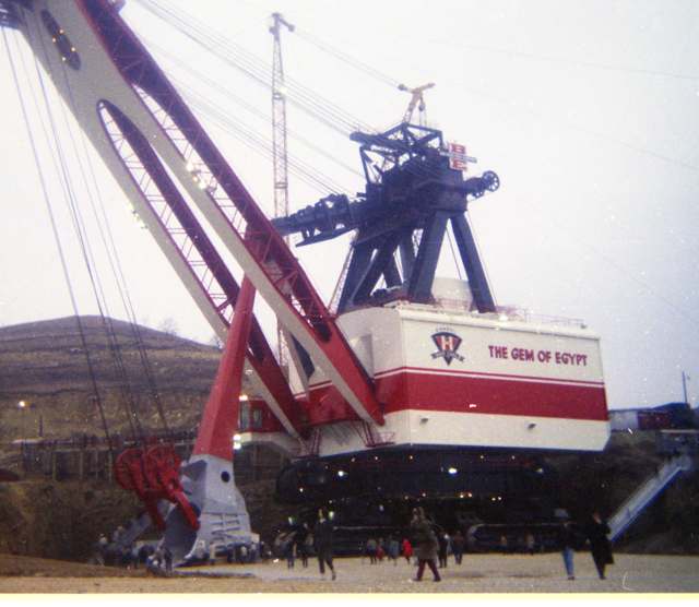
Photo: Csynnes, Wikimedia Commons, CC BY-SA 4.0 · Wikimedia Commons
Local history sources: en.wikipedia.org · en.wikipedia.org · en.wikipedia.org · en.wikipedia.org · commons.wikimedia.org · archive.org
Water
Mostly private wells The water here
- Barnesville97% of residentsBarnesville Reservoirs #1, #2 & Slope Creek Reservoir
- Flushing Village2% of residentsOhio River valley aquifer (wells)
- HCWSD-piedmont1% of residentsGroundwater wells (1 wells)
Hospitals, fire stations and more
Inside Kirkwood Township, Belmont County's boundary: 26 shale and injection wells and 10 spill cases. Press a pin or a name for its whole record and its source.
Shale and injection wells (26)
-
Alabross Kkw Bl 6HUtica shale well
- What it is
- Utica shale well
- Drilled sideways
- Yes
- Operator
- Ascent Resources Utica Llc
- County
- Belmont County
- API well number
- 34013207050000
- Coordinates
- 40.07851, -81.22468
ODNR oil and gas wells (source) ↗ Street map and directions ↗
The point is the surface well head (the pad); a horizontal well runs a mile or more underground from it.
-
Alabtross Kkw Bl 8HUtica shale well
- What it is
- Utica shale well
- Drilled sideways
- Yes
- Operator
- Ascent Resources Utica Llc
- County
- Belmont County
- API well number
- 34013207130000
- Coordinates
- 40.07854, -81.22461
ODNR oil and gas wells (source) ↗ Street map and directions ↗
The point is the surface well head (the pad); a horizontal well runs a mile or more underground from it.
-
Albatross Kkw Bl 2HUtica shale well
- What it is
- Utica shale well
- Drilled sideways
- Yes
- Operator
- Ascent Resources Utica Llc
- County
- Belmont County
- API well number
- 34013207110000
- Coordinates
- 40.07845, -81.22482
ODNR oil and gas wells (source) ↗ Street map and directions ↗
The point is the surface well head (the pad); a horizontal well runs a mile or more underground from it.
-
Albatross Kkw Bl 4HUtica shale well
- What it is
- Utica shale well
- Drilled sideways
- Yes
- Operator
- Ascent Resources Utica Llc
- County
- Belmont County
- API well number
- 34013207120000
- Coordinates
- 40.07848, -81.22475
ODNR oil and gas wells (source) ↗ Street map and directions ↗
The point is the surface well head (the pad); a horizontal well runs a mile or more underground from it.
-
Albert E Kkw Bl 10HUtica shale well
- What it is
- Utica shale well
- Drilled sideways
- Yes
- Operator
- Ascent Resources Utica Llc
- County
- Belmont County
- API well number
- 34013213820000
- Coordinates
- 40.04577, -81.21308
ODNR oil and gas wells (source) ↗ Street map and directions ↗
The point is the surface well head (the pad); a horizontal well runs a mile or more underground from it.
-
Albert S Kkw Bl 6HUtica shale well
- What it is
- Utica shale well
- Drilled sideways
- Yes
- Operator
- Ascent Resources Utica Llc
- County
- Belmont County
- API well number
- 34013213830000
- Coordinates
- 40.04587, -81.21314
ODNR oil and gas wells (source) ↗ Street map and directions ↗
The point is the surface well head (the pad); a horizontal well runs a mile or more underground from it.
-
Albert Se Kkw Bl 8HUtica shale well
- What it is
- Utica shale well
- Drilled sideways
- Yes
- Operator
- Ascent Resources Utica Llc
- County
- Belmont County
- API well number
- 34013213840000
- Coordinates
- 40.04582, -81.21311
ODNR oil and gas wells (source) ↗ Street map and directions ↗
The point is the surface well head (the pad); a horizontal well runs a mile or more underground from it.
-
Albert Sw Kkw Bl 4HUtica shale well
- What it is
- Utica shale well
- Drilled sideways
- Yes
- Operator
- Ascent Resources Utica Llc
- County
- Belmont County
- API well number
- 34013213810000
- Coordinates
- 40.04592, -81.21318
ODNR oil and gas wells (source) ↗ Street map and directions ↗
The point is the surface well head (the pad); a horizontal well runs a mile or more underground from it.
-
Albert W Kkw Bl 2HUtica shale well
- What it is
- Utica shale well
- Drilled sideways
- Yes
- Operator
- Ascent Resources Utica Llc
- County
- Belmont County
- API well number
- 34013213850000
- Coordinates
- 40.04597, -81.21322
ODNR oil and gas wells (source) ↗ Street map and directions ↗
The point is the surface well head (the pad); a horizontal well runs a mile or more underground from it.
-
Boyd Hall A 1HUtica shale well
- What it is
- Utica shale well
- Drilled sideways
- Yes
- Operator
- Expand Operating Llc
- County
- Belmont County
- API well number
- 34013213780000
- Coordinates
- 40.05714, -81.22454
ODNR oil and gas wells (source) ↗ Street map and directions ↗
The point is the surface well head (the pad); a horizontal well runs a mile or more underground from it.
-
Boyd Hall A 3HUtica shale well
- What it is
- Utica shale well
- Drilled sideways
- Yes
- Operator
- Expand Operating Llc
- County
- Belmont County
- API well number
- 34013213790000
- Coordinates
- 40.05708, -81.22455
ODNR oil and gas wells (source) ↗ Street map and directions ↗
The point is the surface well head (the pad); a horizontal well runs a mile or more underground from it.
-
Boyd Hall B 5HUtica shale well
- What it is
- Utica shale well
- Drilled sideways
- Yes
- Operator
- Expand Operating Llc
- County
- Belmont County
- API well number
- 34013213800000
- Coordinates
- 40.05702, -81.22455
ODNR oil and gas wells (source) ↗ Street map and directions ↗
The point is the surface well head (the pad); a horizontal well runs a mile or more underground from it.
-
Boyd Hall B 7HUtica shale well
- What it is
- Utica shale well
- Drilled sideways
- Yes
- Operator
- Expand Operating Llc
- County
- Belmont County
- API well number
- 34013213770000
- Coordinates
- 40.05696, -81.22456
ODNR oil and gas wells (source) ↗ Street map and directions ↗
The point is the surface well head (the pad); a horizontal well runs a mile or more underground from it.
-
Hayes 1-1HUtica shale well
- What it is
- Utica shale well
- Drilled sideways
- Yes
- Operator
- Gulfport Appalachia Llc
- County
- Belmont County
- API well number
- 34013207490000
- Coordinates
- 40.04488, -81.12029
ODNR oil and gas wells (source) ↗ Street map and directions ↗
The point is the surface well head (the pad); a horizontal well runs a mile or more underground from it.
-
Hayes 2-1HUtica shale well
- What it is
- Utica shale well
- Drilled sideways
- Yes
- Operator
- Gulfport Appalachia Llc
- County
- Belmont County
- API well number
- 34013207500000
- Coordinates
- 40.04487, -81.12035
ODNR oil and gas wells (source) ↗ Street map and directions ↗
The point is the surface well head (the pad); a horizontal well runs a mile or more underground from it.
-
Hayes 3-1HUtica shale well
- What it is
- Utica shale well
- Drilled sideways
- Yes
- Operator
- Gulfport Appalachia Llc
- County
- Belmont County
- API well number
- 34013207480000
- Coordinates
- 40.04487, -81.12040
ODNR oil and gas wells (source) ↗ Street map and directions ↗
The point is the surface well head (the pad); a horizontal well runs a mile or more underground from it.
-
Hayes 4-1HUtica shale well
- What it is
- Utica shale well
- Drilled sideways
- Yes
- Operator
- Gulfport Appalachia Llc
- County
- Belmont County
- API well number
- 34013207510000
- Coordinates
- 40.04487, -81.12046
ODNR oil and gas wells (source) ↗ Street map and directions ↗
The point is the surface well head (the pad); a horizontal well runs a mile or more underground from it.
-
Jade 210274 1CUtica shale well
- What it is
- Utica shale well
- Drilled sideways
- Yes
- Operator
- Gulfport Appalachia Llc
- County
- Belmont County
- API well number
- 34013209180000
- Coordinates
- 40.04121, -81.13363
ODNR oil and gas wells (source) ↗ Street map and directions ↗
The point is the surface well head (the pad); a horizontal well runs a mile or more underground from it.
-
Jade 210274 2BUtica shale well
- What it is
- Utica shale well
- Drilled sideways
- Yes
- Operator
- Gulfport Appalachia Llc
- County
- Belmont County
- API well number
- 34013209170000
- Coordinates
- 40.04123, -81.13368
ODNR oil and gas wells (source) ↗ Street map and directions ↗
The point is the surface well head (the pad); a horizontal well runs a mile or more underground from it.
-
Jade 210274 3AUtica shale well
- What it is
- Utica shale well
- Drilled sideways
- Yes
- Operator
- Gulfport Appalachia Llc
- County
- Belmont County
- API well number
- 34013209190000
- Coordinates
- 40.04125, -81.13372
ODNR oil and gas wells (source) ↗ Street map and directions ↗
The point is the surface well head (the pad); a horizontal well runs a mile or more underground from it.
-
Shugert 1-1HUtica shale well
- What it is
- Utica shale well
- Drilled sideways
- Yes
- Operator
- Gulfport Appalachia Llc
- County
- Belmont County
- API well number
- 34013206570100
- Coordinates
- 40.04319, -81.12302
ODNR oil and gas wells (source) ↗ Street map and directions ↗
The point is the surface well head (the pad); a horizontal well runs a mile or more underground from it.
-
Shugert 2-1HUtica shale well
- What it is
- Utica shale well
- Drilled sideways
- Yes
- Operator
- Gulfport Appalachia Llc
- County
- Belmont County
- API well number
- 34013206890000
- Coordinates
- 40.04314, -81.12300
ODNR oil and gas wells (source) ↗ Street map and directions ↗
The point is the surface well head (the pad); a horizontal well runs a mile or more underground from it.
-
Shugert 3-1HUtica shale well
- What it is
- Utica shale well
- Drilled sideways
- Yes
- Operator
- Gulfport Appalachia Llc
- County
- Belmont County
- API well number
- 34013206880000
- Coordinates
- 40.04324, -81.12305
ODNR oil and gas wells (source) ↗ Street map and directions ↗
The point is the surface well head (the pad); a horizontal well runs a mile or more underground from it.
-
Shugert 4-1HUtica shale well
- What it is
- Utica shale well
- Drilled sideways
- Yes
- Operator
- Gulfport Appalachia Llc
- County
- Belmont County
- API well number
- 34013207060000
- Coordinates
- 40.04309, -81.12297
ODNR oil and gas wells (source) ↗ Street map and directions ↗
The point is the surface well head (the pad); a horizontal well runs a mile or more underground from it.
-
Swallie 210041 1CUtica shale well
- What it is
- Utica shale well
- Drilled sideways
- Yes
- Operator
- Gulfport Appalachia Llc
- County
- Belmont County
- API well number
- 34013207830000
- Coordinates
- 40.03903, -81.13878
ODNR oil and gas wells (source) ↗ Street map and directions ↗
The point is the surface well head (the pad); a horizontal well runs a mile or more underground from it.
-
Swallie 210041 2BUtica shale well
- What it is
- Utica shale well
- Drilled sideways
- Yes
- Operator
- Gulfport Appalachia Llc
- County
- Belmont County
- API well number
- 34013207840000
- Coordinates
- 40.03903, -81.13883
ODNR oil and gas wells (source) ↗ Street map and directions ↗
The point is the surface well head (the pad); a horizontal well runs a mile or more underground from it.
Source: ODNR Division of Oil and Gas Resources well inventory (September 2026): drilled Utica, Marcellus and horizontal wells and Class II injection wells not plugged. Older vertical wells are on the full map.
Spills reported since 2021 (10)
-
Fuel Diesel / Diesel Fuel (Vehicle On Or Off Road)2025-12-29 · Kirkwood Twp
- Reported
- 2025-12-29
- What spilled
- Fuel Diesel / Diesel Fuel (Vehicle On Or Off Road)
- Largest amount reported
- 50 gallons
- Where
- Kirkwood Twp, Belmont County
- Ohio EPA district office
- SEDO
- Ohio EPA case number
- 2512EPA0002071
Ohio EPA spill reports (source) ↗ Street map and directions ↗
-
Fuel Diesel / Diesel Fuel (Vehicle On Or Off Road)2025-05-14 · Kirkwood Twp
- Reported
- 2025-05-14
- What spilled
- Fuel Diesel / Diesel Fuel (Vehicle On Or Off Road)
- Where
- Kirkwood Twp, Preble County
- Ohio EPA district office
- SEDO
- Ohio EPA case number
- 2505EPA0000758
Ohio EPA spill reports (source) ↗ Street map and directions ↗
-
Water (H20)2024-02-12 · Kirkwood Twp
- Reported
- 2024-02-12
- What spilled
- Water (H20)
- Where
- Kirkwood Twp, Belmont County
- Ohio EPA district office
- SEDO
- Ohio EPA case number
- 2402EPA0000230
Ohio EPA spill reports (source) ↗ Street map and directions ↗
-
Brine Oil And Gas Related2023-06-20 · Kirkwood Twp
- Reported
- 2023-06-20
- What spilled
- Brine Oil And Gas Related
- Largest amount reported
- 2,520 gallons
- Where
- Kirkwood Twp, Belmont County
- Ohio EPA district office
- SEDO
- Ohio EPA case number
- 2306EPA0001017
Ohio EPA spill reports (source) ↗ Street map and directions ↗
-
Fuel Diesel / Diesel Fuel (Vehicle On Or Off Road)2022-12-12 · Kirkwood Twp
- Reported
- 2022-12-12
- What spilled
- Fuel Diesel / Diesel Fuel (Vehicle On Or Off Road); Oil Hydraulic Fluid(S)
- Where
- Kirkwood Twp, Belmont County
- Ohio EPA district office
- SEDO
- Ohio EPA case number
- 2212EPA0001837
Ohio EPA spill reports (source) ↗ Street map and directions ↗
-
Fuel Diesel / Diesel Fuel (Vehicle On Or Off Road)2022-11-29 · Kirkwood Twp
- Reported
- 2022-11-29
- What spilled
- Fuel Diesel / Diesel Fuel (Vehicle On Or Off Road)
- Largest amount reported
- 75 gallons
- Where
- Kirkwood Twp, Belmont County
- Ohio EPA district office
- SEDO
- Ohio EPA case number
- 2211EPA0001770
Ohio EPA spill reports (source) ↗ Street map and directions ↗
-
Other / All Other / Trade Name / Mixture / Solution Etc2022-07-21 · Kirkwood Twp
- Reported
- 2022-07-21
- What spilled
- Other / All Other / Trade Name / Mixture / Solution Etc
- Largest amount reported
- 1,000 gallons
- Where
- Kirkwood Twp, Belmont County
- Ohio EPA district office
- SEDO
- Ohio EPA case number
- 2207EPA0001109
Ohio EPA spill reports (source) ↗ Street map and directions ↗
-
Fuel Diesel / Diesel Fuel (Vehicle On Or Off Road)2022-01-24 · Kirkwood Twp
- Reported
- 2022-01-24
- What spilled
- Fuel Diesel / Diesel Fuel (Vehicle On Or Off Road)
- Largest amount reported
- 100 gallons
- Where
- Kirkwood Twp, Belmont County
- Ohio EPA district office
- SEDO
- Ohio EPA case number
- 2201EPA0000073
Ohio EPA spill reports (source) ↗ Street map and directions ↗
-
Waste Water2021-02-16 · Kirkwood Twp
- Reported
- 2021-02-16
- What spilled
- Waste Water
- Where
- Kirkwood Twp, Belmont County
- Ohio EPA district office
- SEDO
- Ohio EPA case number
- 2102EPA0000208
Ohio EPA spill reports (source) ↗ Street map and directions ↗
-
Fuel Diesel / Diesel Fuel (Vehicle On Or Off Road)2026-06-01 · Kirkwood Twp
- Reported
- 2026-06-01
- What spilled
- Fuel Diesel / Diesel Fuel (Vehicle On Or Off Road); Oil Motor / Lube Oil / Vehicle
- Largest amount reported
- 25 gallons
- Where
- Kirkwood Twp, Belmont County
- Ohio EPA district office
- SEDO
- Ohio EPA case number
- 2606EPA0000955
Ohio EPA spill reports (source) ↗ Street map and directions ↗
Source: Ohio EPA emergency response spill reports, 2021 to September 2026, one point per case where Ohio EPA placed it. A report is what the caller or responder recorded; amounts are often blank or estimated.
Its ZIP codes
Each ZIP code that touches Kirkwood Township, Belmont County, with the share of its residents who live here and the same headline figures as the ZIP page.
| ZIP | Share | Water | Radon | Home value | Schools | Flood |
|---|---|---|---|---|---|---|
| 43983 Flushing Township and Piedmont | 17% | Mostly private wells | 9.2 pCi/L average radon | Median year built 1965 | Barnesville Exempted Village · 4 stars overall | 0.0% of residents in the 1% floodplain |
| 43713 Barnesville | 5% | Barnesville Reservoirs #1, #2 & Slope Creek Reservoir | 4.8 pCi/L average radon | Median year built 1962 | Barnesville Exempted Village · 4 stars overall | 0.5% of residents in the 1% floodplain |
Local government
Who holds office in Kirkwood Township, Belmont County, how its elections and ballot issues came out, and the state auditor's record.
Money issues on the ballot since 2017: 1 of 1 passed; of those asking for new or higher taxes, 1 of 1.
Ballot issues
| Date | Issue | For | Against | Result |
|---|---|---|---|---|
| 2019-11-05 | Issue: Kirkwood Township - Fire Protection - Renewal | 41 | 10 | Passed (80.39% for) |
| 2017-11-07 | Issue: Kirkwood Township EMS - Additional Levy | 46 | 31 | Passed (59.74% for) |
| 2016-11-08 | Issue: Kirkwood Twp - Renewal Cemeteries | 98 | 55 | Passed (64.05% for) |
Elections for office
| Date | Office | Candidates and votes |
|---|---|---|
| 2021-11-02 | Township Trustee (unofficial count) | Kevin M. Arigoni 37, 51.39%; Ronald F. Temple 35, 48.61% |
| 2019-11-05 | Township Trustee | C. Timothy Lara 35, 100.0% |
| 2017-11-07 | Township Trustees | Kevin Arigoni 52, 37.41%; Ronald Franklin Temple 41, 29.5%; David Merritt 25, 17.99%; Donald G. Loucks 21, 15.11% |
| 2015-11-03 | Township Trustee | C. Timothy Lara 69, 100.0% |
| 2015-11-03 | Township Fiscal Officer | Linda K. Fritter 73, 100.0% |
Winners in bold. Results from the county board of elections' official canvass unless marked.
Auditor of State record
- No fiscal caution, watch or emergency on the Auditor of State's lists.
- Financial Audit, 2023 to 2024, released 2026-07-14
The county
Belmont County: 23 ZIP codes, 29 cities, villages and townships, 64,982 people.
Nearby places
Quick answers
What county is Kirkwood Township, Ohio in?
Kirkwood Township, Belmont County is a township in Belmont County, Ohio, with 412 residents.
When was Kirkwood Township, Ohio founded?
Kirkwood Township, Belmont County was settled 1789 (Robert Kirkwood's settlement). Source
How did Kirkwood Township, Ohio get its name?
Named for Robert Kirkwood, a soldier who fought in the American Revolutionary War and settled in Belmont County in 1789; it is the only Kirkwood Township in Ohio. Source
What ZIP code is Kirkwood Township, Ohio?
Kirkwood Township, Belmont County is served by ZIP codes 43983 and 43713; 43983 holds the largest share of its residents.
Where does Kirkwood Township, Ohio get its water?
The main water source for Kirkwood Township, Belmont County (Barnesville): Mostly private wells.
Cite this page
Cite this page as:
Cracked Buckeye, "Kirkwood Township, Belmont County", https://crackedbuckeye.com/place/kirkwood-township-belmont-county/, built 2026-10-31, accessed [date].
How to cite · Report a correction · Built 2026-10-31
