Local events in Warren Township, Belmont County
Nothing is posted for Warren Township itself yet; here is what is on within 20 miles. All local events in Warren Township, Belmont County
Know a calendar we should watch? Send the link
Checked October 20; the events page is refreshed daily.
How Warren Township, Belmont County began
Warren Township, organized around 1806-1807, surrounds the village of Barnesville in western Belmont County and was powered in its early decades by gristmills and sawmills along Captina Creek and the Stillwater River. Two Native American sites from the Monongahela culture, the Tower Site and the Barnesville Petroglyph, both sit within the township, four and three miles from Barnesville respectively. The township is also home to Olney Friends School, a Quaker boarding school that opened at its present campus in 1876 after Ohio's Wilburite-Gurneyite schism split the Ohio Yearly Meeting, and that became the first USDA Certified Organic high school in the country in 2015.
Incorporated about 1806-1807, by Belmont County commissioners.
Where the name comes from
No documented explanation of why this township, one of five Warren Townships statewide in Ohio, took the name Warren was found in the sources consulted.
Before the town
Warren Township holds two significant Monongahela-culture sites, part of the same Late Prehistoric farming and pottery-making tradition documented at the Opatrny Village Site in neighboring Richland Township. The Tower Site, on a hilltop about four miles northwest of Barnesville at roughly 1,360 feet elevation, was a small village of 2 to 3 acres occupied from about AD 1000 to 1500, its huts, refuse pits, and burials arranged in a ring around an open central plaza; local residents had already disturbed parts of it digging for artifacts before Kent State University conducted formal excavations in the late 1970s that recovered hundreds of animal bone fragments, pottery shards, arrowheads, cannel-coal pendants, shell and bead ornaments, and the remains of three individuals, two female and one male, including one burial pit found intact. Three miles southwest of Barnesville, the Barnesville Petroglyph carries 113 carvings, animal and bird tracks, human faces and feet, geometric figures, snakes, and pits, cut into a sandstone boulder; rock-art specialist James L. Swauger attributed the carvings to Ojibwe-influenced people of the Monongahela culture rather than the earlier Adena culture some had proposed. Neither site is tied by name to a specific historic-era eighteenth-century nation; both predate the Lenape, Shawnee, Wyandot, and Mingo presence in the county.
- Tower Site (village) — hilltop about 4 miles northwest of Barnesville, Warren Township, AD 1000-1500 (Monongahela culture) (en.wikipedia.org)
- Barnesville Petroglyph (other) — sandstone boulder hill about 3 miles southwest of Barnesville, Warren Township, disputed: Adena (c. 500 BC-AD 300) or Monongahela culture (from c. AD 1200) (en.wikipedia.org)
Timeline
- — Monongahela-culture people found the village later called the Tower Site, on a hilltop northwest of the future Barnesville, occupying it until about 1500.
- — Warren Township is organized, roughly this year.
- — Ohio Quakers begin planning a boarding school, the seed of what becomes Olney Friends School.
- — Several gristmills and sawmills are operating in the township, powered by Captina Creek and the Stillwater River.
- — The Ohio Yearly Meeting's boarding school opens to students at Mount Pleasant, Ohio.
- — The Ohio Yearly Meeting divides over doctrinal differences.
- — The Wilburite Quaker faction builds a new school building at the school's present location near Barnesville, in Warren Township.
- — Fire destroys the school's main building; it is rebuilt the same year by November.
- — The Barnesville Petroglyph is added to the National Register of Historic Places on July 15, one of only three Ohio petroglyphs so listed.
- — Kent State University begins excavating the Tower Site after local potholing had already disturbed parts of it.
- — The Tower Site is added to the National Register of Historic Places on June 11.
- — The school and meetinghouse campus is added to the National Register as the Friends Boarding School and Ohio Yearly Meetinghouse Historic District.
- — Olney Friends School receives USDA Organic Certification, becoming the first USDA Certified Organic high school in the United States.
Stories
A Quaker school that split in two
Ohio's Quakers began planning a boarding school as early as 1814, and by 1837 the Ohio Yearly Meeting had one open at Mount Pleasant, north of Barnesville. It did not stay one school for long: American Quakerism was fracturing nationally over doctrine through the mid-1800s, and in 1854 the Ohio Yearly Meeting itself divided. Twenty years later the split reached the school directly, when the original Mount Pleasant building was awarded to the more theologically liberal 'Gurneyite' faction, leaving the more traditionalist 'Wilburite' Friends to build an entirely new school at a fresh site near Barnesville in 1876, the campus that still operates today as Olney Friends School. Fire took the main building in 1910, but it was rebuilt by November of that same year. In the twenty-first century the school found a different way to stand apart: in 2015 it became the first high school in the United States to earn USDA Organic Certification, running its farm to the same standard as any commercial organic operation.
A ring of huts around an empty plaza
Four miles northwest of Barnesville, a hilltop at 1,360 feet held a small Native village for roughly five centuries, from about AD 1000 to 1500. Its people, part of the Monongahela culture that also left the larger Opatrny Village Site in neighboring Richland Township, arranged their huts, storage and refuse pits, and burials in a ring around a central plaza kept deliberately open and free of structures. Local residents had already dug into parts of the site looking for artifacts before Kent State University archaeologists arrived in the late 1970s to excavate it properly, uncovering hundreds of bone fragments, pottery shards, arrowheads, cannel-coal pendants, and shell beads, along with the remains of three people, two women and a man, in burials that had gone otherwise undisturbed. Why the village was abandoned around 1500 is not recorded in any source we consulted; the site, since named the Tower Site, was added to the National Register of Historic Places in 1982.
Photographs
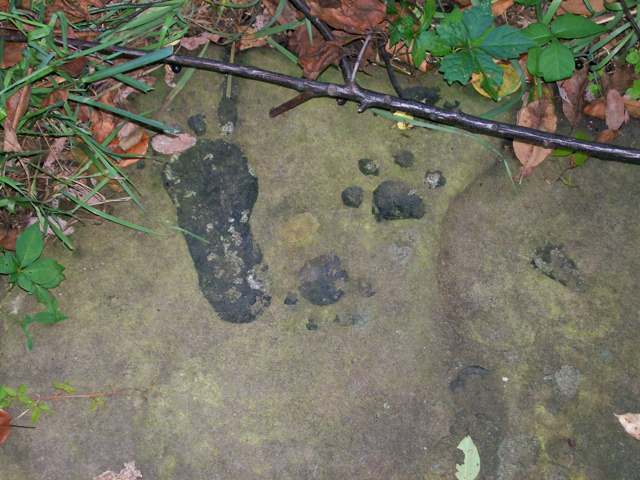
Photo: Bwsmith84, Wikimedia Commons, CC BY 3.0 · Wikimedia Commons
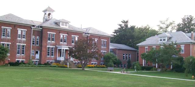
Photo: Bwsmith84, Wikimedia Commons, CC BY 3.0 · Wikimedia Commons
Local history sources: en.wikipedia.org · en.wikipedia.org · en.wikipedia.org · en.wikipedia.org · en.wikipedia.org · commons.wikimedia.org · commons.wikimedia.org
Water
Barnesville Reservoirs #1, #2 & Slope Creek Reservoir The water here
- Barnesville100% of residentsBarnesville Reservoirs #1, #2 & Slope Creek Reservoir
Hospitals, fire stations and more
Inside Warren Township, Belmont County's boundary: 3 high-hazard dams, 1 private school, 1 poor-rated bridge, 33 shale and injection wells and 5 spill cases. Press a pin or a name for its whole record and its source.
High-hazard dams (3)
-
Barnesville Lake Dam PoorTributary To Spencer Creek · condition: poor
- Hazard class
- High: a failure would probably cost a life
- Condition
- Poor (assessed 10/23/2023)
- River or stream
- Tributary To Spencer Creek
- Purpose
- Recreation
- Type
- Earth
- Height
- 32 ft
- Storage
- 153 acre-feet
- Completed
- 1969
- Owner type
- Local Government
- County
- Belmont County
- Nearest town (NID)
- Hendrysburg
- Last inspection
- 11/14/2022
- Emergency action plan
- Yes
- NID ID
- OH00877
National Inventory of Dams record ↗ National Inventory of Dams (source) ↗ Street map and directions ↗
-
Barnesville Reservoir No. 1 DamTrib-North Fork Captina Creek · condition: fair
- Hazard class
- High: a failure would probably cost a life
- Condition
- Fair (assessed 10/23/2023)
- River or stream
- Trib-North Fork Captina Creek
- Purpose
- Water Supply;Recreation
- Type
- Earth
- Height
- 42 ft
- Storage
- 361 acre-feet
- Completed
- 1904
- Owner type
- Local Government
- County
- Belmont County
- Nearest town (NID)
- Alledonia
- Last inspection
- 11/14/2022
- Emergency action plan
- Yes
- NID ID
- OH00299
National Inventory of Dams record ↗ National Inventory of Dams (source) ↗ Street map and directions ↗
-
Barnesville Reservoir No. 2 Dam PoorTrib-North Fork Captina Creek · condition: poor
- Hazard class
- High: a failure would probably cost a life
- Condition
- Poor (assessed 10/23/2023)
- River or stream
- Trib-North Fork Captina Creek
- Purpose
- Water Supply;Recreation
- Type
- Earth
- Height
- 48 ft
- Storage
- 228 acre-feet
- Completed
- 1936
- Owner type
- Local Government
- County
- Belmont County
- Nearest town (NID)
- Alledonia
- Last inspection
- 11/14/2022
- Emergency action plan
- Yes
- NID ID
- OH00300
National Inventory of Dams record ↗ National Inventory of Dams (source) ↗ Street map and directions ↗
Source: U.S. Army Corps of Engineers National Inventory of Dams, August 2026. "High hazard" rates what a failure would cost downstream, not how likely one is; the condition is the state's assessment.
Private schools (1)
-
Olney Friends SchoolPrivate, religious, denomination-affiliated · Barnesville
- Address
- 61830 Sandy Ridge Rd, Barnesville, OH 43713
- Kind
- religious, denomination-affiliated
- Students, 2023-24
- 23
- Teachers (full-time equivalent)
- 10
- Students per teacher
- 2.3
- Phone
- (740) 425-3655
- NCES private school ID
- 01063194
Source: NCES Private School Survey 2023-24.
Bridges rated poor (1)
-
TR 139 over Spencer CreekPoor · built 1980
- Condition
- Poor: a deck, superstructure, substructure or culvert rated 4 or below on the 0 to 9 scale
- What it is
- Culvert
- Built
- 1980
- Length
- 8 ft
- Owner
- County
- Vehicles a day
- 351
- Coordinates
- 40.02996, -81.15702
National Bridge Inventory (source) ↗ Street map and directions ↗
Source: FHWA National Bridge Inventory 2025. "Poor" means one major part rated 4 or below on the 0 to 9 scale; it calls for repair, not closing, unless the state posts or closes the bridge.
Shale and injection wells (33)
-
Axle Wrn Bl 1HUtica shale well
- What it is
- Utica shale well
- Drilled sideways
- Yes
- Operator
- Ascent Resources Utica Llc
- County
- Belmont County
- API well number
- 34013207190000
- Coordinates
- 39.98484, -81.19579
ODNR oil and gas wells (source) ↗ Street map and directions ↗
The point is the surface well head (the pad); a horizontal well runs a mile or more underground from it.
-
Axle Wrn Bl 3HUtica shale well
- What it is
- Utica shale well
- Drilled sideways
- Yes
- Operator
- Ascent Resources Utica Llc
- County
- Belmont County
- API well number
- 34013207260000
- Coordinates
- 39.98487, -81.19575
ODNR oil and gas wells (source) ↗ Street map and directions ↗
The point is the surface well head (the pad); a horizontal well runs a mile or more underground from it.
-
Axle Wrn Bl 5HUtica shale well
- What it is
- Utica shale well
- Drilled sideways
- Yes
- Operator
- Ascent Resources Utica Llc
- County
- Belmont County
- API well number
- 34013207270000
- Coordinates
- 39.98490, -81.19571
ODNR oil and gas wells (source) ↗ Street map and directions ↗
The point is the surface well head (the pad); a horizontal well runs a mile or more underground from it.
-
Axle Wrn Bl 7HUtica shale well
- What it is
- Utica shale well
- Drilled sideways
- Yes
- Operator
- Ascent Resources Utica Llc
- County
- Belmont County
- API well number
- 34013207280000
- Coordinates
- 39.98493, -81.19567
ODNR oil and gas wells (source) ↗ Street map and directions ↗
The point is the surface well head (the pad); a horizontal well runs a mile or more underground from it.
-
Axle Wrn Bl 9HUtica shale well
- What it is
- Utica shale well
- Drilled sideways
- Yes
- Operator
- Ascent Resources Utica Llc
- County
- Belmont County
- API well number
- 34013207250000
- Coordinates
- 39.98481, -81.19582
ODNR oil and gas wells (source) ↗ Street map and directions ↗
The point is the surface well head (the pad); a horizontal well runs a mile or more underground from it.
-
Buckeye Uic Barnesville(Swiw #2) 1 InjectionInjection well (Class II)
- What it is
- Injection well (Class II)
- Operator
- Force Environmental Solutions Llc
- County
- Belmont County
- API well number
- 34013206090000
- Coordinates
- 40.02675, -81.15973
ODNR oil and gas wells (source) ↗ Street map and directions ↗
-
Cattle 210198 1AUtica shale well
- What it is
- Utica shale well
- Drilled sideways
- Yes
- Operator
- Gulfport Appalachia Llc
- County
- Belmont County
- API well number
- 34013208870000
- Coordinates
- 40.03571, -81.14455
ODNR oil and gas wells (source) ↗ Street map and directions ↗
The point is the surface well head (the pad); a horizontal well runs a mile or more underground from it.
-
Cattle 210198 2BUtica shale well
- What it is
- Utica shale well
- Drilled sideways
- Yes
- Operator
- Gulfport Appalachia Llc
- County
- Belmont County
- API well number
- 34013208860000
- Coordinates
- 40.03573, -81.14451
ODNR oil and gas wells (source) ↗ Street map and directions ↗
The point is the surface well head (the pad); a horizontal well runs a mile or more underground from it.
-
Cattle 210198 3CUtica shale well
- What it is
- Utica shale well
- Drilled sideways
- Yes
- Operator
- Gulfport Appalachia Llc
- County
- Belmont County
- API well number
- 34013208880000
- Coordinates
- 40.03575, -81.14446
ODNR oil and gas wells (source) ↗ Street map and directions ↗
The point is the surface well head (the pad); a horizontal well runs a mile or more underground from it.
-
D L Mayberry A 1HUtica shale well
- What it is
- Utica shale well
- Drilled sideways
- Yes
- Operator
- Grenadier Energy Iii, Llc
- County
- Belmont County
- API well number
- 34013216380000
- Coordinates
- 40.01429, -81.15176
ODNR oil and gas wells (source) ↗ Street map and directions ↗
The point is the surface well head (the pad); a horizontal well runs a mile or more underground from it.
-
D L Mayberry A 2HUtica shale well
- What it is
- Utica shale well
- Drilled sideways
- Yes
- Operator
- Grenadier Energy Iii, Llc
- County
- Belmont County
- API well number
- 34013216390000
- Coordinates
- 40.01435, -81.15174
ODNR oil and gas wells (source) ↗ Street map and directions ↗
The point is the surface well head (the pad); a horizontal well runs a mile or more underground from it.
-
D L Mayberry B 3HUtica shale well
- What it is
- Utica shale well
- Drilled sideways
- Yes
- Operator
- Grenadier Energy Iii, Llc
- County
- Belmont County
- API well number
- 34013216370000
- Coordinates
- 40.01440, -81.15173
ODNR oil and gas wells (source) ↗ Street map and directions ↗
The point is the surface well head (the pad); a horizontal well runs a mile or more underground from it.
-
Grand E Wrn Bl 7HUtica shale well
- What it is
- Utica shale well
- Drilled sideways
- Yes
- Operator
- Ascent Resources Utica Llc
- County
- Belmont County
- API well number
- 34013216480000
- Coordinates
- 40.01356, -81.16085
ODNR oil and gas wells (source) ↗ Street map and directions ↗
The point is the surface well head (the pad); a horizontal well runs a mile or more underground from it.
-
Grand Ne Wrn Bl 5HUtica shale well
- What it is
- Utica shale well
- Drilled sideways
- Yes
- Operator
- Ascent Resources Utica Llc
- County
- Belmont County
- API well number
- 34013216470000
- Coordinates
- 40.01350, -81.16087
ODNR oil and gas wells (source) ↗ Street map and directions ↗
The point is the surface well head (the pad); a horizontal well runs a mile or more underground from it.
-
Grand Nw Wrn Bl 3HUtica shale well
- What it is
- Utica shale well
- Drilled sideways
- Yes
- Operator
- Ascent Resources Utica Llc
- County
- Belmont County
- API well number
- 34013216360000
- Coordinates
- 40.01345, -81.16089
ODNR oil and gas wells (source) ↗ Street map and directions ↗
The point is the surface well head (the pad); a horizontal well runs a mile or more underground from it.
-
Grand W Wrn Bl 1HUtica shale well
- What it is
- Utica shale well
- Drilled sideways
- Yes
- Operator
- Ascent Resources Utica Llc
- County
- Belmont County
- API well number
- 34013216460000
- Coordinates
- 40.01340, -81.16090
ODNR oil and gas wells (source) ↗ Street map and directions ↗
The point is the surface well head (the pad); a horizontal well runs a mile or more underground from it.
-
Maldon E Wrn Bl 5HUtica shale well
- What it is
- Utica shale well
- Drilled sideways
- Yes
- Operator
- Ascent Resources Utica Llc
- County
- Belmont County
- API well number
- 34013214610000
- Coordinates
- 40.00892, -81.19891
ODNR oil and gas wells (source) ↗ Street map and directions ↗
The point is the surface well head (the pad); a horizontal well runs a mile or more underground from it.
-
Maldon N Wrn Bl 3HUtica shale well
- What it is
- Utica shale well
- Drilled sideways
- Yes
- Operator
- Ascent Resources Utica Llc
- County
- Belmont County
- API well number
- 34013214600000
- Coordinates
- 40.00887, -81.19891
ODNR oil and gas wells (source) ↗ Street map and directions ↗
The point is the surface well head (the pad); a horizontal well runs a mile or more underground from it.
-
Maldon W Wrn Bl 1HUtica shale well
- What it is
- Utica shale well
- Drilled sideways
- Yes
- Operator
- Ascent Resources Utica Llc
- County
- Belmont County
- API well number
- 34013214590000
- Coordinates
- 40.00881, -81.19891
ODNR oil and gas wells (source) ↗ Street map and directions ↗
The point is the surface well head (the pad); a horizontal well runs a mile or more underground from it.
-
Rock Ridge S Wrn Bl 6HUtica shale well
- What it is
- Utica shale well
- Drilled sideways
- Yes
- Operator
- Ascent Resources Utica Llc
- County
- Belmont County
- API well number
- 34013215880000
- Coordinates
- 39.99837, -81.22724
ODNR oil and gas wells (source) ↗ Street map and directions ↗
The point is the surface well head (the pad); a horizontal well runs a mile or more underground from it.
-
Rock Ridge S Wrn Bl 8HUtica shale well
- What it is
- Utica shale well
- Drilled sideways
- Yes
- Operator
- Ascent Resources Utica Llc
- County
- Belmont County
- API well number
- 34013215870000
- Coordinates
- 39.99833, -81.22719
ODNR oil and gas wells (source) ↗ Street map and directions ↗
The point is the surface well head (the pad); a horizontal well runs a mile or more underground from it.
-
Rock Ridge Se Wrn Bl 10HUtica shale well
- What it is
- Utica shale well
- Drilled sideways
- Yes
- Operator
- Ascent Resources Utica Llc
- County
- Belmont County
- API well number
- 34013215860000
- Coordinates
- 39.99830, -81.22714
ODNR oil and gas wells (source) ↗ Street map and directions ↗
The point is the surface well head (the pad); a horizontal well runs a mile or more underground from it.
-
Rock Ridge Sw Wrn Bl 2HUtica shale well
- What it is
- Utica shale well
- Drilled sideways
- Yes
- Operator
- Ascent Resources Utica Llc
- County
- Belmont County
- API well number
- 34013215900000
- Coordinates
- 39.99844, -81.22735
ODNR oil and gas wells (source) ↗ Street map and directions ↗
The point is the surface well head (the pad); a horizontal well runs a mile or more underground from it.
-
Rock Ridge Sw Wrn Bl 4HUtica shale well
- What it is
- Utica shale well
- Drilled sideways
- Yes
- Operator
- Ascent Resources Utica Llc
- County
- Belmont County
- API well number
- 34013215890000
- Coordinates
- 39.99841, -81.22730
ODNR oil and gas wells (source) ↗ Street map and directions ↗
The point is the surface well head (the pad); a horizontal well runs a mile or more underground from it.
-
Shugert 1-12HUtica shale well
- What it is
- Utica shale well
- Drilled sideways
- Yes
- Operator
- Gulfport Appalachia Llc
- County
- Belmont County
- API well number
- 34013206580100
- Coordinates
- 40.03276, -81.14560
ODNR oil and gas wells (source) ↗ Street map and directions ↗
The point is the surface well head (the pad); a horizontal well runs a mile or more underground from it.
-
Shugert 2-12HUtica shale well
- What it is
- Utica shale well
- Drilled sideways
- Yes
- Operator
- Gulfport Appalachia Llc
- County
- Belmont County
- API well number
- 34013206910000
- Coordinates
- 40.03272, -81.14564
ODNR oil and gas wells (source) ↗ Street map and directions ↗
The point is the surface well head (the pad); a horizontal well runs a mile or more underground from it.
-
Shugert 3-12HUtica shale well
- What it is
- Utica shale well
- Drilled sideways
- Yes
- Operator
- Gulfport Appalachia Llc
- County
- Belmont County
- API well number
- 34013206900000
- Coordinates
- 40.03281, -81.14555
ODNR oil and gas wells (source) ↗ Street map and directions ↗
The point is the surface well head (the pad); a horizontal well runs a mile or more underground from it.
-
Shugert 4-12HUtica shale well
- What it is
- Utica shale well
- Drilled sideways
- Yes
- Operator
- Gulfport Appalachia Llc
- County
- Belmont County
- API well number
- 34013206970000
- Coordinates
- 40.03269, -81.14568
ODNR oil and gas wells (source) ↗ Street map and directions ↗
The point is the surface well head (the pad); a horizontal well runs a mile or more underground from it.
-
Tri-State (Swiw #6) 1 InjectionInjection well (Class II) · Well drilled
- What it is
- Injection well (Class II)
- Status (ODNR)
- Well drilled
- Operator
- Allstate Disposal Llc
- County
- Belmont County
- API well number
- 34013215020000
- Coordinates
- 40.01369, -81.21435
ODNR oil and gas wells (source) ↗ Street map and directions ↗
-
Victor Ne Wrn Bl 5HUtica shale well
- What it is
- Utica shale well
- Drilled sideways
- Yes
- Operator
- Ascent Resources Utica Llc
- County
- Belmont County
- API well number
- 34013216070000
- Coordinates
- 40.01922, -81.18300
ODNR oil and gas wells (source) ↗ Street map and directions ↗
The point is the surface well head (the pad); a horizontal well runs a mile or more underground from it.
-
Victor Ne Wrn Bl 7HUtica shale well
- What it is
- Utica shale well
- Drilled sideways
- Yes
- Operator
- Ascent Resources Utica Llc
- County
- Belmont County
- API well number
- 34013216080000
- Coordinates
- 40.01917, -81.18296
ODNR oil and gas wells (source) ↗ Street map and directions ↗
The point is the surface well head (the pad); a horizontal well runs a mile or more underground from it.
-
Victor Nw Wrn Bl 1HUtica shale well
- What it is
- Utica shale well
- Drilled sideways
- Yes
- Operator
- Ascent Resources Utica Llc
- County
- Belmont County
- API well number
- 34013216050000
- Coordinates
- 40.01931, -81.18308
ODNR oil and gas wells (source) ↗ Street map and directions ↗
The point is the surface well head (the pad); a horizontal well runs a mile or more underground from it.
-
Victor Nw Wrn Bl 3HUtica shale well
- What it is
- Utica shale well
- Drilled sideways
- Yes
- Operator
- Ascent Resources Utica Llc
- County
- Belmont County
- API well number
- 34013216060000
- Coordinates
- 40.01926, -81.18304
ODNR oil and gas wells (source) ↗ Street map and directions ↗
The point is the surface well head (the pad); a horizontal well runs a mile or more underground from it.
Source: ODNR Division of Oil and Gas Resources well inventory (September 2026): drilled Utica, Marcellus and horizontal wells and Class II injection wells not plugged. Older vertical wells are on the full map.
Spills reported since 2021 (5)
-
Drilling Waste / Cuttings2025-12-11 · Warren Twp
- Reported
- 2025-12-11
- What spilled
- Drilling Waste / Cuttings
- Largest amount reported
- 5 gallons
- Where
- Warren Twp, Belmont County
- Ohio EPA district office
- SEDO
- Ohio EPA case number
- 2512EPA0001989
Ohio EPA spill reports (source) ↗ Street map and directions ↗
-
Fuel Diesel / Diesel Fuel (Vehicle On Or Off Road)2025-02-15 · Warren Twp
- Reported
- 2025-02-15
- What spilled
- Fuel Diesel / Diesel Fuel (Vehicle On Or Off Road)
- Largest amount reported
- 75 gallons
- Where
- Warren Twp, Belmont County
- Ohio EPA district office
- SEDO
- Ohio EPA case number
- 2502EPA0000203
Ohio EPA spill reports (source) ↗ Street map and directions ↗
-
Fuel Diesel / Diesel Fuel (Vehicle On Or Off Road)2022-05-10 · Warren Twp
- Reported
- 2022-05-10
- What spilled
- Fuel Diesel / Diesel Fuel (Vehicle On Or Off Road)
- Largest amount reported
- 10 gallons
- Where
- Warren Twp, Belmont County
- Ohio EPA district office
- SEDO
- Ohio EPA case number
- 2205EPA0000671
Ohio EPA spill reports (source) ↗ Street map and directions ↗
-
Brine Oil And Gas Related2021-08-20 · Warren Twp
- Reported
- 2021-08-20
- What spilled
- Brine Oil And Gas Related
- Where
- Warren Twp, Belmont County
- Ohio EPA district office
- SEDO
- Ohio EPA case number
- 2108EPA0001308
Ohio EPA spill reports (source) ↗ Street map and directions ↗
-
Material Unknown2026-06-11 · Barnesville
- Reported
- 2026-06-11
- What spilled
- Material Unknown
- Where
- Barnesville, Belmont County
- Ohio EPA district office
- SEDO
- Ohio EPA case number
- 2606EPA0001040
Ohio EPA spill reports (source) ↗ Street map and directions ↗
Source: Ohio EPA emergency response spill reports, 2021 to September 2026, one point per case where Ohio EPA placed it. A report is what the caller or responder recorded; amounts are often blank or estimated.
Its ZIP codes
Each ZIP code that touches Warren Township, Belmont County, with the share of its residents who live here and the same headline figures as the ZIP page.
| ZIP | Share | Water | Radon | Home value | Schools | Flood |
|---|---|---|---|---|---|---|
| 43713 Barnesville | 24% | Barnesville Reservoirs #1, #2 & Slope Creek Reservoir | 4.8 pCi/L average radon | Median year built 1962 | Barnesville Exempted Village · 4 stars overall | 0.5% of residents in the 1% floodplain |
Local government
Who holds office in Warren Township, Belmont County, how its elections and ballot issues came out, and the state auditor's record.
Money issues on the ballot since 2015: 3 of 3 passed; of those asking for new or higher taxes, 1 of 1.
Ballot issues
| Date | Issue | For | Against | Result |
|---|---|---|---|---|
| 2021-11-02 | Issue: Warren Township Park Levy | 56 | 24 | Passed (70.0% for), unofficial |
| 2018-11-06 | Issue: Warren TWP - Roads and Bridges - Renewal | 405 | 296 | Passed (57.77% for) |
| 2018-11-06 | Issue: Warren TWP - Fire - Renewal | 433 | 276 | Passed (61.07% for) |
| 2017-11-07 | Issue: Warren Township EMS - Additional Levy | 234 | 160 | Passed (59.39% for) |
| 2016-11-08 | Issue: Warren Twp - Electic Aggregation | 436 | 365 | Passed (54.43% for) |
| 2016-11-08 | Issue: Warren Twp - Gas Aggregation | 445 | 349 | Passed (56.05% for) |
| 2015-11-03 | Issue: Warren TWP Park District Levy | 99 | 27 | Passed (78.57% for) |
Elections for office
| Date | Office | Candidates and votes |
|---|---|---|
| 2021-11-02 | Township Trustee (unofficial count) | Russell Barker 718, 49.11%; Jimmy Lee Grear 744, 50.89% |
| 2019-11-05 | Township Trustee | Martin D. Hissom 456, 65.33%; Tim Smith 242, 34.67% |
| 2019-11-05 | Township Fiscal Officer | Kent Gallagher 607, 100.0% |
| 2017-11-07 | Township Trustees | Jimmy L. Grear 755, 51.68%; Russell Barker 706, 48.32% |
| 2015-11-03 | Township Trustee | David Hissom 1,398, 100.0% |
| 2015-11-03 | Township Fiscal Officer | Kent W. Gallagher 934, 59.95%; Tracey K. Rockwell 624, 40.05% |
Winners in bold. Results from the county board of elections' official canvass unless marked.
Auditor of State record
- No fiscal caution, watch or emergency on the Auditor of State's lists.
- Agreed Upon Procedures, 2022 to 2023, released 2024-10-10
The county
Belmont County: 23 ZIP codes, 29 cities, villages and townships, 64,982 people.
Nearby places
Quick answers
What county is Warren Township, Ohio in?
Warren Township, Belmont County is a township in Belmont County, Ohio, with 1,718 residents.
When was Warren Township, Ohio founded?
Warren Township, Belmont County was incorporated about 1806-1807. Founders on record: Belmont County commissioners. Source
How did Warren Township, Ohio get its name?
No documented explanation of why this township, one of five Warren Townships statewide in Ohio, took the name Warren was found in the sources consulted.
What ZIP code is Warren Township, Ohio?
Most of Warren Township, Belmont County is in ZIP code 43713.
Where does Warren Township, Ohio get its water?
The main water source for Warren Township, Belmont County (Barnesville): Barnesville Reservoirs #1, #2 & Slope Creek Reservoir.
Cite this page
Cite this page as:
Cracked Buckeye, "Warren Township, Belmont County", https://crackedbuckeye.com/place/warren-township-belmont-county/, built 2026-10-31, accessed [date].
How to cite · Report a correction · Built 2026-10-31
