Local events in Barnesville
5 events in the next 90 days from 4 public calendars. All local events in Barnesville
Checked October 20; the events page is refreshed daily.
Notable people from Barnesville
Ohioans tied to this place, each with a sourced profile. All notable Ohioans
How Barnesville began
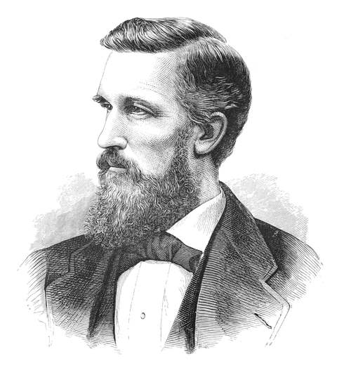
Barnesville was laid out in November 1808 by James Barnes, a Maryland-born settler who had founded a Barnesville of his own back in Montgomery County, Maryland, before clearing land, building a house, and starting a tannery, general store, and orchards in Warren Township from 1806. The village incorporated in 1835 and had grown to six stores and a steam mill by 1833. It is the birthplace of Elisha Gray, the inventor who filed his own telephone caveat at the patent office on the same morning in 1876 that Alexander Graham Bell's lawyer filed Bell's application, and lost the resulting two-year fight over who got credit for the telephone. Three miles southwest of the village, a sandstone boulder carries 113 Native American carvings known as the Barnesville Petroglyph, though it lies within neighboring Warren Township.
Settled 1806 (James Barnes), platted November 1808, incorporated 1835, by James Barnes.
Where the name comes from
Named for first settler James Barnes, a Maryland native who had earlier founded a town of the same name, Barnesville, in Montgomery County, Maryland, before relocating to Ohio.
Before the town
No Native village or camp on the exact site of Barnesville village itself is documented in the sources consulted. Three miles southwest of the village, however, within neighboring Warren Township, a sandstone boulder atop a wooded hill carries the Barnesville Petroglyph, 113 carvings of animal and bird tracks, human faces and feet, geometric figures, snakes, and pits, one of only three petroglyphs in Ohio on the National Register of Historic Places; see the Warren Township file for full detail. Its makers are debated between the Adena culture (roughly 500 BC to AD 300) and, per rock-art specialist James L. Swauger's analysis, Ojibwe-influenced people of the Monongahela culture active in the upper Ohio Valley from about AD 1200.
Timeline
- — James Barnes settles in Warren Township, Belmont County, clearing land and building a house, tannery, general store, and orchards.
- — Barnes lays out the town of Barnesville in November.
- — The growing settlement is recorded as having six stores and a steam mill.
- — Barnesville incorporates as a village.
- — Joseph Watt and Son found a foundry that grows into the Watt Car and Wheel Company, a major local industry.
- — Barnesville-born inventor Elisha Gray's patent lawyer files Gray's telephone caveat the same morning Alexander Graham Bell's application is filed; the Patent Office rules years later that Gray, though first to conceive the invention, failed to complete it before Bell demonstrated a working device, and awards Bell the patent.
- — The Barnesville Baltimore and Ohio Railroad Depot is built on Mulberry Street.
- — The Barnesville B&O Railroad Depot is added to the National Register of Historic Places on August 8.
Stories
The farm boy who lost the telephone by hours
Elisha Gray grew up on a Quaker farm outside Barnesville before studying at Oberlin College and becoming one of the era's most prolific electrical inventors. On February 11, 1876, he sketched out his design for a telephone using a liquid transmitter, and had his patent lawyer prepare a caveat, a kind of provisional filing that describes an invention without yet demanding examination. On the morning of Monday, February 14, 1876, Gray's notarized caveat was filed at the U.S. Patent Office. That same morning, a few hours earlier or later depending on whose account is believed, Alexander Graham Bell's lawyer filed Bell's own telephone patent application. The two years of litigation that followed turned on a fine legal distinction: the Patent Office found that Gray had genuinely been first to conceive of the variable-resistance telephone, but that only Bell had done the further work needed to complete and demonstrate it, and awarded Bell the patent and the credit that followed. Gray, who filed patents on more than 70 other inventions in his career, is remembered in Barnesville as the local boy who invented the telephone and lost it anyway, by a margin of hours that has never been fully settled.
Photographs
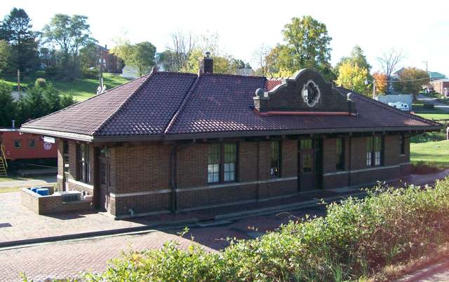
Photo: Bwsmith84, Wikimedia Commons, CC BY 3.0 · Wikimedia Commons
Local history sources: en.wikipedia.org · en.wikipedia.org · en.wikipedia.org · commons.wikimedia.org
Historic places
1 place in Barnesville on the National Register of Historic Places. Press a pin or a name for its whole record.
-
Barnesville Baltimore and Ohio Railroad DepotBuilding · Barnesville · listed 1985
- Address
- 300 E. Church St.
- Where
- Barnesville, Belmont County · ZIP 43713
- What it is
- Building
- Listed on the National Register
- 1985
- NRIS reference number
- 85001694
- Coordinates
- 39.98870, -81.17318
National Register file (NPS) ↗ Search Wikipedia ↗ Street map and directions ↗ On the Cracked Buckeye map
Source: National Park Service, National Register of Historic Places point file. The listing year is shown where NPS's certification date agrees with the listing's reference number. Listing recognizes significance; it does not restrict a private owner.
Water
Barnesville Reservoirs #1, #2 & Slope Creek Reservoir The water here
- Barnesville100% of residentsBarnesville Reservoirs #1, #2 & Slope Creek Reservoir
Hospitals, fire stations and more
Inside Barnesville's boundary: 1 hospital, 3 health centers, 2 nursing homes, 1 fire or EMS station, 3 public schools, 1 library, 1 museum, 1 police station and 1 spill case. Press a pin or a name for its whole record and its source.
Hospitals (1)
-
Barnesville Hospital AssociationGeneral hospital · Barnesville
- What it is
- General hospital
- Address
- 639 West Main Street, Barnesville, OH 43713
- County
- Belmont County
- Beds
- 25
- Ownership
- Non-profit
- Medicare overall rating
- not rated
- Emergency department (Medicare)
- Yes
- Medicare reports it as
- Barnesville Hospital Association, Inc
- Phone
- (740) 425-5101
- Medicare ID
- 361321
Medicare Care Compare ↗ Where HIFLD got this record ↗ HIFLD hospitals (source) ↗ Street map and directions ↗
Source: HIFLD hospitals inventory via FEMA (closed hospitals it still lists left out, hospitals opened since added), with Medicare Care Compare ratings matched by name and address.
Community health centers (3)
-
BARNESVILLE FAMILY HEALTH CENTERHealth center · Barnesville
- Run by
- a federally qualified health center
- Setting
- Clinic
- City
- Barnesville
- Coordinates
- 39.98809, -81.17705
Find a Health Center (HRSA) ↗ HRSA data (source) ↗ Street map and directions ↗
-
OHHC Barnesville Dental CenterHealth center · Barnesville
- Run by
- a federally qualified health center
- Setting
- Clinic
- City
- Barnesville
- Coordinates
- 39.98809, -81.17705
Find a Health Center (HRSA) ↗ HRSA data (source) ↗ Street map and directions ↗
-
OHIO HILLS HEALTH SERVICESHealth center · Barnesville
- Run by
- a federally qualified health center
- Setting
- Clinic
- City
- Barnesville
- Coordinates
- 39.98809, -81.17705
Find a Health Center (HRSA) ↗ HRSA data (source) ↗ Street map and directions ↗
Source: HRSA health center service delivery sites, active, September 2026 (school-based sites left out). Health centers see patients whether or not they have insurance, with fees on a sliding scale.
Nursing homes (2)
-
Emerald Pointe Health and Rehab Ctr3 of 5 stars · Barnesville
- Address
- 100 Michelli Street, Barnesville, OH 43713
- Certified beds
- 64
- Residents on an average day
- 62
- Medicare overall rating
- 3 of 5 stars
- Health inspections
- 3 of 5 stars
- Staffing
- 3 of 5 stars
- Quality measures
- 4 of 5 stars
- Penalties since 2023
- none
- Ownership
- For profit - Corporation
- Chain
- FOUNDATIONS HEALTH SOLUTIONS
- Takes
- Medicare and Medicaid
- Phone
- (740) 425-5400
- Medicare ID
- 366352
Medicare Care Compare ↗ CMS nursing home data (source) ↗ Street map and directions ↗
-
The Enclave at Barnesville1 of 5 stars · Barnesville
- Address
- 400 Carrie Avenue, Barnesville, OH 43713
- Certified beds
- 96
- Residents on an average day
- 51
- Medicare overall rating
- 1 of 5 stars
- Health inspections
- 1 of 5 stars
- Staffing
- 2 of 5 stars
- Quality measures
- 4 of 5 stars
- Penalties since 2023
- 3 fines totalling $334,135, 1 payment denial (latest 2024-06-21)
- Ownership
- For profit - Limited Liability company
- Takes
- Medicare and Medicaid
- Phone
- (740) 425-3648
- Medicare ID
- 366261
Medicare Care Compare ↗ CMS nursing home data (source) ↗ Street map and directions ↗
Source: CMS Care Compare nursing home provider and penalties files; Medicare star ratings run 1 to 5.
Fire and EMS stations (1)
-
Barnesville Volunteer Fire Department Station 12Barnesville
- Address
- 125 East Church Street, Barnesville, OH 43713
- Coordinates
- 39.98886, -81.17532
USGS National Map structures (source) ↗ Street map and directions ↗
Source: USGS National Map structures (most Ohio records last updated 2019 to 2022), checked against the Columbus and Cleveland station lists. The department that answers a call is set by jurisdiction and mutual aid, not by distance.
Public schools (3)
-
Barnesville Elementary School4 of 5 stars · Barnesville
- Address
- 210 W Church St, Barnesville, OH 43713
- School district
- Barnesville Ex Vill School District
- Kind (NCES)
- Regular School
- Students, 2023-24
- 533
- Teachers (full-time equivalent)
- 26.53
- Report card, 2025-26
- 4 of 5 stars
- Performance index
- 85%
- Ohio building IRN
- 001594
- NCES school ID
- 390452002120
NCES school record ↗ Ohio School Report Card ↗ Street map and directions ↗
-
Barnesville High School3.5 of 5 stars · Barnesville
- Address
- 910 Shamrock Dr, Barnesville, OH 43713
- School district
- Barnesville Ex Vill School District
- Kind (NCES)
- Regular School
- Students, 2023-24
- 385
- Teachers (full-time equivalent)
- 20.58
- Report card, 2025-26
- 3.5 of 5 stars
- Performance index
- 78.4%
- Four-year graduation rate
- 96.8%
- Ohio building IRN
- 001602
- NCES school ID
- 390452002121
NCES school record ↗ Ohio School Report Card ↗ Street map and directions ↗
-
Barnesville Middle School4.5 of 5 stars · Barnesville
- Address
- 970 Shamrock Dr, Barnesville, OH 43713
- School district
- Barnesville Ex Vill School District
- Kind (NCES)
- Regular School
- Students, 2023-24
- 430
- Teachers (full-time equivalent)
- 21.05
- Report card, 2025-26
- 4.5 of 5 stars
- Performance index
- 80.3%
- Ohio building IRN
- 064600
- NCES school ID
- 390452010822
NCES school record ↗ Ohio School Report Card ↗ Street map and directions ↗
Source: NCES EDGE public school locations 2024-25 and Common Core of Data 2023-24 (type, students, teachers); Ohio School Report Cards 2025-26 (Department of Education and Workforce), matched by name within the district.
Public libraries (1)
-
Barnesville Hutton Memorial Public LibraryCentral library · Barnesville
- Address
- 308 E Main St, Barnesville, OH 43713
- What it is
- Central library
- Library system
- Barnesville Hutton Memorial Library
- Open
- 2,547 hours a year, 52 weeks
- Building
- 9,873 sq ft
- System's visits, FY2024
- 20,020
- System's loans, FY2024
- 76,206
- People the system serves
- 7,839
- Phone
- (740) 425-1651
IMLS Public Libraries Survey (source) ↗ Street map and directions ↗
Source: IMLS Public Libraries Survey FY2024 (outlets and their systems). Any Ohio resident can get a free card at any Ohio public library.
Museums, historical societies, gardens and zoos (1)
-
Belmont County Historical SocietyHistorical society · Barnesville
- What it is
- Historical society
- City
- Barnesville
- Coordinates
- 39.99250, -81.17662
Search Wikipedia ↗ IMLS Museum Data Files (source) ↗ Street map and directions ↗
The museum list is IMLS's 2018 file; a museum may have closed or moved since.
Source: IMLS Museum Data Files, 2018.
Police stations (1)
-
Barnesville Police DepartmentBarnesville
- Address
- 132 North Arch Street, Barnesville, OH 43713
- Coordinates
- 39.98813, -81.17527
USGS National Map structures (source) ↗ Street map and directions ↗
Source: USGS National Map structures, police stations, corrected and completed by hand (September 2026). The department that answers a call is set by jurisdiction, not by distance.
Spills reported since 2021 (1)
-
Fuel Gasoline ( 25% Ethanol Not E85)2025-12-26 · Barnesville
- Reported
- 2025-12-26
- What spilled
- Fuel Gasoline ( 25% Ethanol Not E85); Oil Motor / Lube Oil / Vehicle
- Where
- Barnesville, Belmont County
- Ohio EPA district office
- SEDO
- Ohio EPA case number
- 2512EPA0002056
Ohio EPA spill reports (source) ↗ Street map and directions ↗
Source: Ohio EPA emergency response spill reports, 2021 to September 2026, one point per case where Ohio EPA placed it. A report is what the caller or responder recorded; amounts are often blank or estimated.
Its ZIP codes
Each ZIP code that touches Barnesville, with the share of its residents who live here and the same headline figures as the ZIP page.
| ZIP | Share | Water | Radon | Home value | Schools | Flood |
|---|---|---|---|---|---|---|
| 43713 Barnesville | 56% | Barnesville Reservoirs #1, #2 & Slope Creek Reservoir | 4.8 pCi/L average radon | Median year built 1962 | Barnesville Exempted Village · 4 stars overall | 0.5% of residents in the 1% floodplain |
Local government
Who holds office in Barnesville, how its elections and ballot issues came out, and the state auditor's record.
Money issues on the ballot since 2017: 1 of 1 passed; of those asking for new or higher taxes, 1 of 1.
Ballot issues
| Date | Issue | For | Against | Result |
|---|---|---|---|---|
| 2018-11-06 | Issue: Barnesville Village - Fire - Replacement | 763 | 481 | Passed (61.33% for) |
| 2017-11-07 | Issue: Barnesville Village EMS - Additional Levy | 419 | 231 | Passed (64.46% for) |
| 2015-11-03 | Issue: Village of Barnesville - Electrical Aggregation Ordinance | 481 | 544 | Failed (46.93% for) |
Elections for office
| Date | Office | Candidates and votes |
|---|---|---|
| 2021-11-02 | Village Council (unofficial count) | Steven Hill 357, 19.39%; Tony C. Johnson 328, 17.82%; Leslie Tickhill 409, 22.22%; Courtney Valine 265, 14.39%; Brian Yarnall 482, 26.18% |
| 2019-11-05 | Village Council | Terry McCort 276, 67.65%; Write-In: Steven Hill 122, 29.9% |
| 2019-11-05 | Mayor | Dale Bunting 337, 100.0% |
| 2017-11-07 | Village Council | Scott O. Gallagher 483, 30.65%; Leslie A. Tickhill 402, 25.51%; Tony C. Johnson 359, 22.78%; Jamie L. Betts 332, 21.07% |
| 2015-11-03 | Village Council | Terry McCort 759, 91.56%; Write-In: Brad Hudson 42, 5.07% |
| 2015-11-03 | Mayor | Dale Bunting 853, 100.0% |
Winners in bold. Results from the county board of elections' official canvass unless marked.
Auditor of State record
- No fiscal caution, watch or emergency on the Auditor of State's lists.
- Financial Audit, 2023 to 2024, released 2026-04-14
The county
Belmont County: 23 ZIP codes, 29 cities, villages and townships, 64,982 people.
Nearby places
Rain and snow
How much has actually fallen on Barnesville, day by day, from 1889 to now. Daily totals, not averages.
- rain, last 30 days
- 2.18 in
- 2026-09-30 to 2026-10-29
- rain so far in 2026
- 47.3 in
- 8.6 in above normal for the date
- snow so far in 2026
- 20.6 in
- a normal year brings 26.8 in
- a normal year
- 45.5 in
- average of 30 years, 1991-2020
| Month | Rain (in) | Snow (in) | Days counted |
|---|---|---|---|
| October 2026 | 2.18 | — | 29 |
| September 2026 | 5.16 | — | 30 |
| August 2026 | 8.73 | — | 31 |
| July 2026 | 4.63 | — | 31 |
| June 2026 | 5.24 | — | 30 |
| May 2026 | 6.46 | — | 31 |
| April 2026 | 4.08 | — | 30 |
| March 2026 | 7.41 | 3.3 | 31 |
| February 2026 | 1.28 | 2.8 | 28 |
| January 2026 | 2.10 | 14.5 | 31 |
| December 2025 | 2.45 | 10.2 | 31 |
| November 2025 | 2.30 | 0.1 | 30 |
| Wettest year | 2004 — 62.6 in |
|---|---|
| Driest year | 1930 — 24.4 in |
| Snowiest year | 1978 — 64.7 in |
| Wettest day on record | 11 August 1980 — 5.12 in |
| Heaviest snowfall in a day | 17 December 1890 — 17.01 in |
| Deepest snow on the ground | 18 February 2003 — 20.00 in |
47% of these days are measurements from a gauge inside Barnesville; the rest are estimated from the nearest gauges around it.
49,946 days of records, 1889-09-01 to 2026-10-29. Source: NOAA NCEI GHCN-Daily, 3,240 gauges in and around Ohio. A day is "gauged" when a gauge standing inside the boundary reported it, and the value is the mean of those gauges. Otherwise it is interpolated by inverse distance from every gauge reporting within 50 miles. Nothing is carried forward, back-filled or smoothed. Against NOAA nClimDiv county monthly precipitation over 136,848 complete county-months (checked 2026-10-31): correlation 0.9515, median absolute difference 0.217 in a month. Built 2026-10-31 from the Cracked Buckeye precipitation archive. Snow is the softer number — snowfall is measured by hand with a ruler, no agency publishes a gridded county snowfall series, and blowing snow defeats every observer.
Environmental permits and filings
What Ohio EPA has on file for Barnesville: permits, inspections, violations, cleanups and the state loans behind sewer and water work. Every line links to the agency's own document.
- facilities and sites on file
- 14
- those placed on the map inside Barnesville
| Program | Facilities and sites |
|---|---|
| Hazardous waste | 7 |
| State water loans | 3 |
| Air pollution | 1 |
| Brownfield | 1 |
| Public drinking water | 1 |
| State sewer loans | 1 |
| Date | Facility or site | What |
|---|---|---|
| BARNESVILLE VILLAGE | Public drinking water notice of violation | |
| BARNESVILLE PWS | Public drinking water compliance letter | |
| ASCENT RESOURCES - GRAND WRN BL | Air pollution report | |
| ASCENT RESOURCES - GRAND WRN BL | Air pollution inspection | |
| BARNESVILLE PWS | Public drinking water inspection | |
| BARNESVILLE PWS | Public drinking water notice of violation | |
| BARNESVILLE PWS | Public drinking water inspection | |
| BARNESVILLE PWS | Public drinking water inspection | |
| BARNESVILLE PWS | Public drinking water inspection | |
| BARNESVILLE PWS | Public drinking water inspection | |
| BARNESVILLE PWS | Public drinking water warning letter | |
| ASCENT RESOURCES - GRAND WRN BL | Air pollution permit | |
| BARNESVILLE PWS | State water loans | |
| ASCENT RESOURCES - GRAND WRN BL | Air pollution permit | |
| BARNESVILLE PWS | Public drinking water compliance letter | |
| BARNESVILLE PWS | Public drinking water plan | |
| BARNESVILLE PWS | Public drinking water compliance letter | |
| BARNESVILLE PWS | State water loans | |
| BARNESVILLE PWS | Public drinking water letter | |
| BARNESVILLE PWS | State water loans | |
| BARNESVILLE PWS | Public drinking water | |
| BARNESVILLE PWS | Public drinking water report | |
| BARNESVILLE PWS | Public drinking water plan | |
| BARNESVILLE PWS | State water loans | |
| VILLAGE OF BARNESVILLE | Brownfield assessment |
Source: Ohio EPA eDocument portal (edocpub.epa.ohio.gov), indexed 2026-10-14. Facilities are placed on the map from Ohio EPA's own map layers, EPA's Facility Registry, coordinates written in the filings, or a geocoded street address. A permit filed under a private person's name (most are household septic systems) is counted but never named, placed or linked; licenses for individual workers and open-burning notices are left out entirely.
Quick answers
What county is Barnesville, Ohio in?
Barnesville is a village in Belmont County, Ohio, with 4,025 residents.
When was Barnesville, Ohio founded?
Barnesville was settled 1806 (James Barnes); laid out November 1808; incorporated 1835. Founders on record: James Barnes. Source
How did Barnesville, Ohio get its name?
Named for first settler James Barnes, a Maryland native who had earlier founded a town of the same name, Barnesville, in Montgomery County, Maryland, before relocating to Ohio. Source
What ZIP code is Barnesville, Ohio?
Most of Barnesville is in ZIP code 43713.
Where does Barnesville, Ohio get its water?
The main water source for Barnesville (Barnesville): Barnesville Reservoirs #1, #2 & Slope Creek Reservoir.
Cite this page
Cite this page as:
Cracked Buckeye, "Barnesville, Belmont County", https://crackedbuckeye.com/place/barnesville/, built 2026-10-31, accessed [date].
How to cite · Report a correction · Built 2026-10-31
