Chagrin Falls
Village · Cuyahoga County · 4,188 residents · 1.85% municipal income tax
Local events in Chagrin Falls
47 events in the next 90 days from 5 public calendars. All local events in Chagrin Falls
Checked October 20; the events page is refreshed daily.
Notable people from Chagrin Falls
Ohioans tied to this place, each with a sourced profile. All notable Ohioans
History from Chagrin Falls
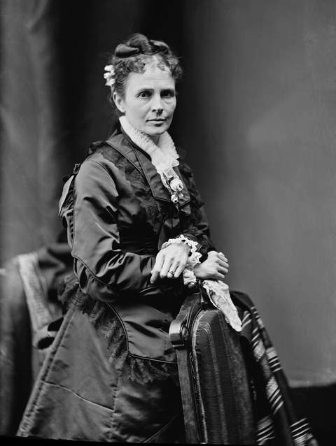
People and inventions tied to this place, each with its sources. All people · All inventions
How Chagrin Falls began
Chagrin Falls grew up around the High Falls of the Chagrin River, first bought around the falls by Seth Henderson of Newburgh, whose 1834 house later became the site of the Church of Christ Scientist. Laid out in 1837 and incorporated on March 12, 1844 from parts of three townships in two counties, it became a small mill town where axes, iron goods, paper, and woodenware were manufactured alongside flour, wool, and lumber mills powered by the falls; a young James A. Garfield worked there as a carpenter on the Disciples of Christ church in 1852, years before he became president. The river itself carries a chain of renamed history in its own name: shown as the Elk River on a 1755 map, it became 'Shaguin' honoring French trader Sieur De Saguin around 1742, then was anglicized to Chagrin by surveyor Seth Pease in 1797 while mapping the Western Reserve.
Settled 1834 (Seth Henderson's house, the first structure recorded at the falls), platted 1837, incorporated March 12, 1844, from parts of three townships in two counties, by Seth Henderson (early landowner); Curtiss Bullard (first mayor after 1844 incorporation).
Where the name comes from
The village takes its name from the Chagrin River and its falls. The river itself appears as the Elk River on a 1755 map, was later called 'Shaguin,' a name believed to honor Sieur De Saguin, a French trader who dealt with Indigenous peoples in the region around 1742, and was anglicized from Shaguin to Chagrin by surveyor Seth Pease in 1797 while he mapped the Connecticut Western Reserve.
Before the town
No source we reviewed identifies a specific, named Native American village, mound, or treaty site within present Chagrin Falls. The Chagrin River's own name preserves a layered history of contact-era naming: it was called the Elk River as late as a 1755 map, then 'Shaguin' by the 1740s in connection with French trader Sieur De Saguin's dealings with the Native peoples of the region, before English-speaking surveyor Seth Pease anglicized that to 'Chagrin' in 1797. This places French-Native trade activity along the river specifically in the 1740s, decades before Euro-American settlement of the falls itself in the 1830s.
Nations recorded here: Lenape (Delaware), Wyandot.
Timeline
- — French trader Sieur De Saguin deals with Indigenous peoples along the river that later takes an anglicized version of his name.
- — A map of the region shows the river later called the Chagrin as the 'Elk River.'
- — Surveyor Seth Pease anglicizes the river's name from 'Shaguin' to 'Chagrin' while mapping the Connecticut Western Reserve.
- — Seth Henderson of Newburgh builds a house at the falls, the first structure recorded there; the site later becomes the Church of Christ Scientist.
- — The village is laid out around the High Falls of the Chagrin River.
- — The settlement counts 601 residents.
- — Chagrin Falls incorporates as a village from parts of three townships in two counties, with Curtiss Bullard as first mayor.
- — Future president James A. Garfield works as a carpenter on the local Disciples of Christ church.
- — A narrow-gauge railroad to Solon is built.
- — A dam at the Adams Bag Company in Chagrin Falls is photographed, documenting the industrial use of the falls' waterpower.
- — The Cleveland & Chagrin Falls Electric Railway Company begins operating in the village.
- — The U.S. 422 freeway opens, diverting through-traffic away from downtown Chagrin Falls.
- — Chagrin Falls receives a National Main Street designation, and the village settles an eminent domain dispute over riverfront property for $850,000.
Stories
A French trader's name, twice removed
The river that gives Chagrin Falls its name carried at least two earlier identities before English speakers ever wrote it down as 'Chagrin.' An English map from 1755 labeled it the Elk River. Sometime before that, around 1742, it had already picked up a different name among the French traders working the region -- 'Shaguin,' remembered as an honor to a trader called Sieur De Saguin, who dealt directly with the Indigenous peoples living along its banks. It was not until 1797, when surveyor Seth Pease mapped the newly opened Connecticut Western Reserve, that 'Shaguin' was anglicized into 'Chagrin' -- the name that stuck, attached first to the river and then, four decades later, to the mill village that grew up at its falls.
Axes, paper, and a future president's carpentry
The falls that gave the village its industry powered mills turning out flour, wool, and lumber, and manufactories along the riverbank produced axes, iron goods, paper, and woodenware through the mid-1800s -- an 1890 photograph of the dam at the Adams Bag Company shows that industrial use of the water still running strong decades after the village's 1844 incorporation. In 1852, a 20-year-old James A. Garfield, not yet a congressman, general, or president, worked in the village as a carpenter helping to build the local Disciples of Christ church, a small, ordinary job in a mill town nearly thirty years before he would be elected to the White House.
Photographs
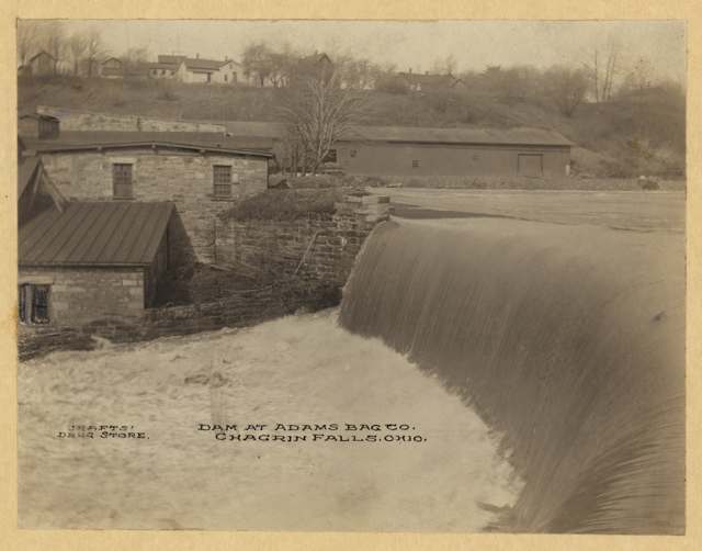
Photo: Library of Congress, Prints and Photographs Online Catalog (Wittemann Collection), public domain · Wikimedia Commons
Local history sources: en.wikipedia.org · case.edu · en.wikipedia.org · commons.wikimedia.org
Historic places
5 places in Chagrin Falls on the National Register of Historic Places. Press a pin or a name for its whole record.
-
Adams Bag Company Paper Mill and Sack FactoryBuilding · Chagrin Falls · listed 2012
- Address
- 218 Cleveland St.
- Where
- Chagrin Falls, Cuyahoga County · ZIP 44022
- What it is
- Building
- Listed on the National Register
- 2012
- NRIS reference number
- 12000391
- Coordinates
- 41.43530, -81.38560
National Register file (NPS) ↗ Search Wikipedia ↗ Street map and directions ↗ On the Cracked Buckeye map
-
Chagrin Falls Township HallBuilding · Chagrin Falls · listed 1974
- Address
- 83 N. Main St.
- Where
- Chagrin Falls, Cuyahoga County · ZIP 44022
- What it is
- Building
- Listed on the National Register
- 1974
- NRIS reference number
- 74001432
- Coordinates
- 41.43172, -81.39264
National Register file (NPS) ↗ Search Wikipedia ↗ Street map and directions ↗ On the Cracked Buckeye map
-
Chagrin Falls Triangle Park Commercial District (Boundary Increase)Historic district · Chagrin Falls · listed 1995
- Address
- Jct. of N. Main and E. Orange Sts., extending E and S
- Where
- Chagrin Falls, Cuyahoga County · ZIP 44022
- What it is
- Historic district
- Listed on the National Register
- 1995
- NRIS reference number
- 95000634
- Coordinates
- 41.43227, -81.39181
National Register file (NPS) ↗ Search Wikipedia ↗ Street map and directions ↗ On the Cracked Buckeye map
-
March, George, HouseBuilding · Chagrin Falls · listed 1978
- Address
- 126 E. Washington St.
- Where
- Chagrin Falls, Cuyahoga County · ZIP 44022
- What it is
- Building
- Listed on the National Register
- 1978
- NRIS reference number
- 78002037
- Coordinates
- 41.42967, -81.38712
National Register file (NPS) ↗ Search Wikipedia ↗ Street map and directions ↗ On the Cracked Buckeye map
-
Stoneman, Joseph, HouseBuilding · Chagrin Falls · listed 1975
- Address
- 18 E. Orange St.
- Where
- Chagrin Falls, Cuyahoga County · ZIP 44022
- What it is
- Building
- Listed on the National Register
- 1975
- NRIS reference number
- 75001358
- Coordinates
- 41.43298, -81.39217
National Register file (NPS) ↗ Search Wikipedia ↗ Street map and directions ↗ On the Cracked Buckeye map
Source: National Park Service, National Register of Historic Places point file. The listing year is shown where NPS's certification date agrees with the listing's reference number. Listing recognizes significance; it does not restrict a private owner.
Water
The Five Mile Crib, a small structure about 5 miles out in Lake Erie north of Cleveland's Edgewater Park The water here
- Cleveland Public Water System57% of residentsLake Erie
- Chagrin Falls Village36% of residentsLake Erie
- Paw Paw Lake6% of residentsGroundwater wells (2 wells)
Hospitals, fire stations and more
Inside Chagrin Falls's boundary: 1 nursing home, 1 fire or EMS station, 3 public schools, 1 private school, 2 poor-rated bridges, 1 library, 1 museum, 1 police station, 2 Toxics Release Inventory facilities and 2 spill cases. Press a pin or a name for its whole record and its source.
Nursing homes (1)
-
The Laurels of Chagrin Falls3 of 5 stars · Chagrin Falls
- Address
- 150 Cleveland Street, Chagrin Falls, OH 44022
- Certified beds
- 82
- Residents on an average day
- 37
- Medicare overall rating
- 3 of 5 stars
- Health inspections
- 3 of 5 stars
- Staffing
- 3 of 5 stars
- Quality measures
- 2 of 5 stars
- Penalties since 2023
- none
- Ownership
- For profit - Limited Liability company
- Chain
- CIENA HEALTHCARE/LAUREL HEALTH CARE
- Takes
- Medicare and Medicaid
- Phone
- (440) 247-4200
- Medicare ID
- 366274
Medicare Care Compare ↗ CMS nursing home data (source) ↗ Street map and directions ↗
Source: CMS Care Compare nursing home provider and penalties files; Medicare star ratings run 1 to 5.
Fire and EMS stations (1)
-
Chagrin Falls Fire DepartmentChagrin Falls
- Address
- 21 West Washington Street, Chagrin Falls, OH 44022
- Coordinates
- 41.42932, -81.39255
USGS National Map structures (source) ↗ Street map and directions ↗
Source: USGS National Map structures (most Ohio records last updated 2019 to 2022), checked against the Columbus and Cleveland station lists. The department that answers a call is set by jurisdiction and mutual aid, not by distance.
Public schools (3)
-
Chagrin Falls High School5 of 5 stars · Chagrin Falls
- Address
- 400 E Washington St, Chagrin Falls, OH 44022
- School district
- Chagrin Falls Ex Vill School District
- Kind (NCES)
- Regular School
- Students, 2023-24
- 562
- Teachers (full-time equivalent)
- 36.8
- Report card, 2025-26
- 5 of 5 stars
- Performance index
- 101.1%
- Four-year graduation rate
- 97.5%
- Ohio building IRN
- 005751
- NCES school ID
- 390452802159
NCES school record ↗ Ohio School Report Card ↗ Street map and directions ↗
-
Chagrin Falls Intermediate Elementary School5 of 5 stars · Chagrin Falls
- Address
- 77 E Washington St, Chagrin Falls, OH 44022
- School district
- Chagrin Falls Ex Vill School District
- Kind (NCES)
- Regular School
- Students, 2023-24
- 371
- Teachers (full-time equivalent)
- 25
- Report card, 2025-26
- 5 of 5 stars
- Performance index
- 100.2%
- Ohio building IRN
- 033548
- NCES school ID
- 390452802656
NCES school record ↗ Ohio School Report Card ↗ Street map and directions ↗
-
Chagrin Falls Middle School5 of 5 stars · Chagrin Falls
- Address
- 342 E Washington St, Chagrin Falls, OH 44022
- School district
- Chagrin Falls Ex Vill School District
- Kind (NCES)
- Regular School
- Students, 2023-24
- 261
- Teachers (full-time equivalent)
- 20
- Report card, 2025-26
- 5 of 5 stars
- Performance index
- 96.9%
- Ohio building IRN
- 005769
- NCES school ID
- 390452802160
NCES school record ↗ Ohio School Report Card ↗ Street map and directions ↗
Source: NCES EDGE public school locations 2024-25 and Common Core of Data 2023-24 (type, students, teachers); Ohio School Report Cards 2025-26 (Department of Education and Workforce), matched by name within the district.
Private schools (1)
-
St Joan of Arc SchoolPrivate, Catholic · Chagrin Falls
- Address
- 498 E Washington St, Chagrin Falls, OH 44022
- Kind
- Catholic
- Students, 2023-24
- 113
- Teachers (full-time equivalent)
- 12.6
- Students per teacher
- 8.96825
- Phone
- (440) 247-6530
- NCES private school ID
- 01058333
Source: NCES Private School Survey 2023-24.
Bridges rated poor (2)
-
Miles Road Cr 11 over Chagrin RiverPoor · built 1915
- Condition
- Poor: a deck, superstructure, substructure or culvert rated 4 or below on the 0 to 9 scale
- What it is
- Bridge
- Built
- 1915
- Length
- 39 ft
- Owner
- County
- Vehicles a day
- 4,146
- Coordinates
- 41.42584, -81.39798
National Bridge Inventory (source) ↗ Street map and directions ↗
-
N Main St Cr 264 over Branch Chagrin RiverPoor · built 1857
- Condition
- Poor: a deck, superstructure, substructure or culvert rated 4 or below on the 0 to 9 scale
- What it is
- Bridge
- Built
- 1857
- Length
- 35 ft
- Owner
- County
- Vehicles a day
- 7,070
- Coordinates
- 41.43133, -81.39200
National Bridge Inventory (source) ↗ Street map and directions ↗
Source: FHWA National Bridge Inventory 2025. "Poor" means one major part rated 4 or below on the 0 to 9 scale; it calls for repair, not closing, unless the state posts or closes the bridge.
Public libraries (1)
-
Chagrin Falls Branch LibraryBranch · Chagrin Falls
- Address
- 100 E. Orange St., Chagrin Falls, OH 44022
- What it is
- Branch
- Library system
- Cuyahoga County Public Library
- Open
- 3,483 hours a year, 52 weeks
- Building
- 12,838 sq ft
- System's visits, FY2024
- 3,917,784
- System's loans, FY2024
- 11,584,178
- People the system serves
- 626,288
- Phone
- (440) 247-3556
IMLS Public Libraries Survey (source) ↗ Street map and directions ↗
Source: IMLS Public Libraries Survey FY2024 (outlets and their systems). Any Ohio resident can get a free card at any Ohio public library.
Museums, historical societies, gardens and zoos (1)
-
Chagrin Falls Historical SocietyHistorical society · Chagrin Falls
- What it is
- Historical society
- City
- Chagrin Falls
- Coordinates
- 41.42996, -81.38574
Search Wikipedia ↗ IMLS Museum Data Files (source) ↗ Street map and directions ↗
The museum list is IMLS's 2018 file; a museum may have closed or moved since.
Source: IMLS Museum Data Files, 2018.
Police stations (1)
-
Chagrin Falls Police DepartmentChagrin Falls
- Address
- 21 West Washington Street, Chagrin Falls, OH 44022
- Coordinates
- 41.42931, -81.39253
USGS National Map structures (source) ↗ Street map and directions ↗
Source: USGS National Map structures, police stations, corrected and completed by hand (September 2026). The department that answers a call is set by jurisdiction, not by distance.
Facilities reporting toxic releases (2)
-
Chase Packaging Corp Paper MillToxics Release Inventory · Chagrin Falls
- Address
- 218 Cleveland St, Chagrin Falls, OH 44022
- County
- Cuyahoga County
- Status
- Reports to the Toxics Release Inventory (active)
- EPA program ID
- 44022CHSPC218CL
- EPA registry ID
- 110067426388
EPA facility record ↗ EPA Facility Registry Service (source) ↗ Street map and directions ↗
-
Ivex of Ohio, Inc.Toxics Release Inventory · Chagrin Falls
- Address
- 218 Cleveland Street, Chagrin Falls, OH 44022
- County
- Cuyahoga County
- Status
- Reports to the Toxics Release Inventory (active)
- EPA program ID
- 44022VXFHN218CL
- EPA registry ID
- 110000735198
EPA facility record ↗ EPA Facility Registry Service (source) ↗ Street map and directions ↗
Source: EPA Facility Registry Service, Toxics Release Inventory reporters. Reporting a release is required of large users of listed chemicals; it is not by itself a violation.
Spills reported since 2021 (2)
-
Oil Petroleum Not Otherwise Specified (Nos)2022-10-18 · Chagrin Falls
- Reported
- 2022-10-18
- What spilled
- Oil Petroleum Not Otherwise Specified (Nos)
- Where
- Chagrin Falls, Cuyahoga County
- Ohio EPA district office
- NEDO
- Ohio EPA case number
- 2210EPA0001563
Ohio EPA spill reports (source) ↗ Street map and directions ↗
-
Sewage Human Reached water2021-03-11 · Chagrin Falls
- Reported
- 2021-03-11
- What spilled
- Sewage Human
- Reached a waterway
- 99 - Unnamed
- Where
- Chagrin Falls, Cuyahoga County
- Ohio EPA district office
- NEDO
- Ohio EPA case number
- 2103EPA0000312
Ohio EPA spill reports (source) ↗ Street map and directions ↗
Source: Ohio EPA emergency response spill reports, 2021 to September 2026, one point per case where Ohio EPA placed it. A report is what the caller or responder recorded; amounts are often blank or estimated.
Its ZIP codes
Each ZIP code that touches Chagrin Falls, with the share of its residents who live here and the same headline figures as the ZIP page.
| ZIP | Share | Water | Radon | Home value | Schools | Flood |
|---|---|---|---|---|---|---|
| 44022 Chagrin Falls | 24% | The Five Mile Crib, a small structure about 5 miles out in Lake Erie north of Cleveland's Edgewater Park | 2.6 pCi/L average radon | Median year built 1966 | Chagrin Falls Exempted Village · 5 stars overall | 0.8% of residents in the 1% floodplain |
Local government
Who holds office in Chagrin Falls, how its elections and ballot issues came out, and the state auditor's record.
Auditor of State record
- No fiscal caution, watch or emergency on the Auditor of State's lists.
- Financial Audit, 2023 to 2024, released 2026-08-25
- OP&F Examination, 2024, released 2026-05-21
- Financial Audit, 2021 to 2022, released 2025-01-21
The county
Cuyahoga County: 52 ZIP codes, 59 cities, villages and townships, 1,270,867 people.
Nearby places
Rain and snow
How much has actually fallen on Chagrin Falls, day by day, from 1871 to now. Daily totals, not averages.
- rain, last 30 days
- 1.73 in
- 2026-09-29 to 2026-10-28
- rain so far in 2026
- 36.2 in
- 2.4 in below normal for the date
- snow so far in 2026
- 53.4 in
- a normal year brings 81.4 in
- a normal year
- 46.4 in
- average of 30 years, 1991-2020
| Month | Rain (in) | Snow (in) | Days counted |
|---|---|---|---|
| October 2026 | 1.73 | — | 28 |
| September 2026 | 3.24 | — | 30 |
| August 2026 | 7.29 | — | 31 |
| July 2026 | 3.00 | — | 31 |
| June 2026 | 2.59 | — | 30 |
| May 2026 | 4.34 | 0.2 | 31 |
| April 2026 | 6.72 | 0.1 | 30 |
| March 2026 | 3.60 | 2.4 | 31 |
| February 2026 | 1.02 | 11.4 | 28 |
| January 2026 | 2.68 | 39.2 | 31 |
| December 2025 | 3.00 | 18.9 | 31 |
| November 2025 | 2.48 | 14.1 | 30 |
| Wettest year | 2011 — 69.0 in |
|---|---|
| Driest year | 1933 — 25.6 in |
| Snowiest year | 2010 — 129.2 in |
| Wettest day on record | 14 September 1979 — 3.81 in |
| Heaviest snowfall in a day | 4 January 2010 — 14.80 in |
| Deepest snow on the ground | 6 February 1977 — 30.00 in |
Mostly estimated. Only 1% of these days come from a gauge standing inside Chagrin Falls - the rest are worked out from the nearest gauges around it, so read them as close estimates rather than readings.
56,914 days of records, 1871-01-01 to 2026-10-28. Source: NOAA NCEI GHCN-Daily, 3,240 gauges in and around Ohio. A day is "gauged" when a gauge standing inside the boundary reported it, and the value is the mean of those gauges. Otherwise it is interpolated by inverse distance from every gauge reporting within 50 miles. Nothing is carried forward, back-filled or smoothed. Against NOAA nClimDiv county monthly precipitation over 136,848 complete county-months (checked 2026-10-31): correlation 0.9515, median absolute difference 0.217 in a month. Built 2026-10-31 from the Cracked Buckeye precipitation archive. Snow is the softer number — snowfall is measured by hand with a ruler, no agency publishes a gridded county snowfall series, and blowing snow defeats every observer.
Environmental permits and filings
What Ohio EPA has on file for Chagrin Falls: permits, inspections, violations, cleanups and the state loans behind sewer and water work. Every line links to the agency's own document.
- facilities and sites on file
- 15
- those placed on the map inside Chagrin Falls
| Program | Facilities and sites |
|---|---|
| State sewer loans | 8 |
| Hazardous waste | 3 |
| Air pollution | 1 |
| Public drinking water | 1 |
| State water loans | 1 |
| Wastewater and stormwater discharge | 1 |
| Date | Facility or site | What |
|---|---|---|
| CHAGRIN FALLS VILLAGE PWS | Public drinking water violation resolved | |
| CHAGRIN FALLS VILLAGE PWS | Public drinking water notice of violation | |
| CHAGRIN FALLS VILLAGE PWS | Public drinking water report | |
| CHAGRIN FALLS VILLAGE PWS | Public drinking water notice of violation | |
| CHAGRIN FALLS VILLAGE PWS | Public drinking water notice of violation | |
| CHAGRIN FALLS VILLAGE PWS | Public drinking water letter | |
| CHAGRIN FALLS VILLAGE PWS | Public drinking water plan | |
| CHAGRIN FALLS VILLAGE PWS | Public drinking water inspection | |
| CHAGRIN FALLS VILLAGE PWS | Public drinking water notice of violation | |
| CHAGRIN FALLS VILLAGE PWS | Public drinking water violation resolved | |
| CHAGRIN FALLS VILLAGE PWS | Public drinking water notice of violation | |
| CHAGRIN FALLS VILLAGE PWS | Public drinking water report | |
| CHAGRIN FALLS VILLAGE PWS | Public drinking water notice of violation | |
| EVERGEEN CEMETERY IMPROVEMENTS | Wastewater and stormwater discharge permit | |
| CHAGRIN FALLS VILLAGE PWS | Public drinking water inspection | |
| CHAGRIN FALLS VILLAGE PWS | Public drinking water inspection | |
| CHAGRIN FALLS VILLAGE PWS | Public drinking water compliance letter | |
| CHAGRIN FALLS VILLAGE PWS | Public drinking water letter | |
| CHAGRIN FALLS VILLAGE PWS | Public drinking water inspection | |
| CHAGRIN FALLS VILLAGE PWS | Public drinking water inspection | |
| CHAGRIN FALLS VILLAGE PWS | Public drinking water notice of violation | |
| CHAGRIN FALLS VILLAGE PWS | Public drinking water compliance letter | |
| CHAGRIN FALLS VILLAGE PWS | Public drinking water report | |
| CHAGRIN FALLS MEADOW LANE WWTP | State sewer loans | |
| CHAGRIN FALLS MEADOW LANE WWTP | State sewer loans |
Source: Ohio EPA eDocument portal (edocpub.epa.ohio.gov), indexed 2026-10-14. Facilities are placed on the map from Ohio EPA's own map layers, EPA's Facility Registry, coordinates written in the filings, or a geocoded street address. A permit filed under a private person's name (most are household septic systems) is counted but never named, placed or linked; licenses for individual workers and open-burning notices are left out entirely.
Quick answers
What county is Chagrin Falls, Ohio in?
Chagrin Falls is a village in Cuyahoga County, Ohio, with 4,188 residents.
When was Chagrin Falls, Ohio founded?
Chagrin Falls was settled 1834 (Seth Henderson's house, the first structure recorded at the falls); laid out 1837; incorporated March 12, 1844, from parts of three townships in two counties. Founders on record: Seth Henderson (early landowner); Curtiss Bullard (first mayor after 1844 incorporation). Source
How did Chagrin Falls, Ohio get its name?
The village takes its name from the Chagrin River and its falls. Source
What ZIP code is Chagrin Falls, Ohio?
Most of Chagrin Falls is in ZIP code 44022.
Where does Chagrin Falls, Ohio get its water?
The main water source for Chagrin Falls (Cleveland Public Water System): The Five Mile Crib, a small structure about 5 miles out in Lake Erie north of Cleveland's Edgewater Park.
Cite this page
Cite this page as:
Cracked Buckeye, "Chagrin Falls, Cuyahoga County", https://crackedbuckeye.com/place/chagrin-falls/, built 2026-10-31, accessed [date].
How to cite · Report a correction · Built 2026-10-31
