Moreland Hills
Village · Cuyahoga County · 3,466 residents · 1% municipal income tax
Local events in Moreland Hills
4 events in the next 90 days from 2 public calendars. All local events in Moreland Hills
Checked October 20; the events page is refreshed daily.
Notable people from Moreland Hills
Ohioans tied to this place, each with a sourced profile. All notable Ohioans
How Moreland Hills began
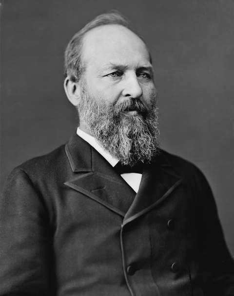
Settlement in what became Moreland Hills began in 1815 near where State Route 87 crosses the Chagrin River, within Orange Township, organized in 1820 and known through the 1800s for steam sawmills, cheese factories, and farms. James A. Garfield, the 20th US president, was born there on November 19, 1831, while the ground was still part of Orange Township; that same year, on October 25-26, Joseph Smith, Sidney Rigdon, and Oliver Cowdery held the Latter-day Saint church's Orange Conference at the home of Serenes Burnett nearby. Orange Township split into five municipalities -- Moreland Hills, Hunting Valley, Orange Village, Pepper Pike, and Woodmere -- in the early 1900s, with Moreland Hills incorporating in 1929 over the township's southeast quadrant and adopting a village charter in 1972.
Settled 1815, near the crossing of State Route 87 and the Chagrin River, incorporated village, 1929, from the southeast quadrant of Orange Township; village charter adopted 1972.
Where the name comes from
No source we reviewed explains the origin of the name Moreland Hills.
Before the town
No source we reviewed identifies a specific, named Native American village, mound, or treaty site within present Moreland Hills; the land was part of Orange Township, organized in 1820 on ground ceded to the United States by the 1795 Treaty of Greenville.
Nations recorded here: Lenape (Delaware), Wyandot.
Timeline
- — Settlement begins near the point where State Route 87 crosses the Chagrin River.
- — Orange Township, which will include the future Moreland Hills, organizes.
- — James A. Garfield, later the 20th US president, is born in a log cabin on ground that is still part of Orange Township and later becomes Moreland Hills.
- — Joseph Smith, Sidney Rigdon, and Oliver Cowdery, the three leading figures of the early Latter-day Saint church, hold the two-day Orange Conference at the home of Serenes Burnett, at the southeast corner of today's Ohio Route 87 and Chagrin River Road.
- — The Cleveland-Chagrin Falls Railway begins serving the area as a commuter line, spurring residential development.
- — Orange Township divides into five municipalities: Moreland Hills, Hunting Valley, Orange Village, Pepper Pike, and Woodmere.
- — Moreland Hills incorporates as a village, covering the southeast quadrant of the original Orange Township.
- — Hiram House, the country's second settlement house after Chicago's Hull House and now a state historical landmark, relocates to Harvard Road and State Route 91.
- — Moreland Hills adopts a village charter establishing a mayor-council government.
Stories
A president's birth and a prophet's conference, the same year
In 1831, the farmland that would become Moreland Hills hosted two moments that later history would treat very differently. On November 19, a farm couple's fifth child, James Abram Garfield, was born in a log cabin there -- a birth that drew no particular notice at the time, since nothing yet marked the infant as a future president. Less than a month earlier, on October 25 and 26, the ground a short distance away hosted people whose fame was already established: Joseph Smith, Sidney Rigdon, and Oliver Cowdery, the three central figures of the young Church of Jesus Christ of Latter-day Saints, gathered at the home of Serenes Burnett for what is remembered in church history as the Orange Conference. Both events happened on what was, at the time, simply Orange Township land -- neither a president's birthplace nor a church conference site yet, just a corner of farm country that history would return to mark twice over.
Photographs
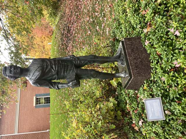
Photo: Slodov1wiki (Wikimedia Commons, Wiki Loves Monuments 2025), CC BY-SA 4.0 · Wikimedia Commons
Local history sources: en.wikipedia.org · en.wikipedia.org · commons.wikimedia.org · en.wikipedia.org
Water
The Five Mile Crib, a small structure about 5 miles out in Lake Erie north of Cleveland's Edgewater Park The water here
- Cleveland Public Water System57% of residentsLake Erie
- Chagrin Falls Village36% of residentsLake Erie
- Paw Paw Lake6% of residentsGroundwater wells (2 wells)
Hospitals, fire stations and more
Inside Moreland Hills's boundary: 2 public schools, 1 museum, 1 police station, 1 Superfund site and 4 spill cases. Press a pin or a name for its whole record and its source.
Public schools (2)
-
Ballard Brady Middle School5 of 5 stars · Pepper Pike
- Address
- 32000 Chagrin Blvd, Pepper Pike, OH 44124
- School district
- Orange City School District
- Kind (NCES)
- Regular School
- Students, 2023-24
- 436
- Teachers (full-time equivalent)
- 36
- Report card, 2025-26
- 5 of 5 stars
- Performance index
- 97.1%
- Ohio building IRN
- 003400
- NCES school ID
- 391001602597
NCES school record ↗ Ohio School Report Card ↗ Street map and directions ↗
-
Moreland Hills Elementary School5 of 5 stars · Pepper Pike
- Address
- 32000 Chagrin Blvd, Pepper Pike, OH 44124
- School district
- Orange City School District
- Kind (NCES)
- Regular School
- Students, 2023-24
- 951
- Teachers (full-time equivalent)
- 57
- Report card, 2025-26
- 5 of 5 stars
- Performance index
- 95.6%
- Ohio building IRN
- 142554
- NCES school ID
- 391001604592
NCES school record ↗ Ohio School Report Card ↗ Street map and directions ↗
Source: NCES EDGE public school locations 2024-25 and Common Core of Data 2023-24 (type, students, teachers); Ohio School Report Cards 2025-26 (Department of Education and Workforce), matched by name within the district.
Museums, historical societies, gardens and zoos (1)
-
Moreland Hills Historical SocietyHistorical society · Moreland Hills
- What it is
- Historical society
- City
- Moreland Hills
- Coordinates
- 41.43632, -81.44454
Search Wikipedia ↗ IMLS Museum Data Files (source) ↗ Street map and directions ↗
The museum list is IMLS's 2018 file; a museum may have closed or moved since.
Source: IMLS Museum Data Files, 2018.
Police stations (1)
-
Moreland Hills Police DepartmentChagrin Falls
- Address
- 4350 Som Center Road, Chagrin Falls, OH 44022
- Coordinates
- 41.43589, -81.44429
USGS National Map structures (source) ↗ Street map and directions ↗
Source: USGS National Map structures, police stations, corrected and completed by hand (September 2026). The department that answers a call is set by jurisdiction, not by distance.
Superfund sites (1)
-
Ellendale Road Mercury SpillSuperfund program · Moreland Hills
- Address
- 3849 Ellendale Rd, Moreland Hills, OH 44022
- County
- Cuyahoga County
- Status
- Superfund program site, not on the National Priorities List
- EPA program ID
- OHN000522278
- EPA registry ID
- 110072196251
EPA facility record ↗ EPA Facility Registry Service (source) ↗ Street map and directions ↗
Source: EPA Facility Registry Service, Superfund (SEMS) and National Priorities List sites. Many program sites were assessed and needed no cleanup.
Spills reported since 2021 (4)
-
Fuel Gasoline ( 25% Ethanol Not E85) Reached water2023-12-19 · Moreland Hills
- Reported
- 2023-12-19
- What spilled
- Fuel Gasoline ( 25% Ethanol Not E85); Oil Motor / Lube Oil / Vehicle
- Reached a waterway
- 18 - Chagrin River
- Where
- Moreland Hills, Cuyahoga County
- Ohio EPA district office
- NEDO
- Ohio EPA case number
- 2312EPA0002068
Ohio EPA spill reports (source) ↗ Street map and directions ↗
-
Fuel Diesel / Diesel Fuel (Vehicle On Or Off Road)2023-05-31 · Willoughby Hills
- Reported
- 2023-05-31
- What spilled
- Fuel Diesel / Diesel Fuel (Vehicle On Or Off Road)
- Where
- Willoughby Hills, Lake County
- Ohio EPA district office
- NEDO
- Ohio EPA case number
- 2305EPA0000896
Ohio EPA spill reports (source) ↗ Street map and directions ↗
-
Fuel Diesel / Diesel Fuel (Vehicle On Or Off Road)2021-06-09 · Moreland Hills
- Reported
- 2021-06-09
- What spilled
- Fuel Diesel / Diesel Fuel (Vehicle On Or Off Road)
- Largest amount reported
- 50 gallons
- Where
- Moreland Hills, Cuyahoga County
- Ohio EPA district office
- NEDO
- Ohio EPA case number
- 2106EPA0000822
Ohio EPA spill reports (source) ↗ Street map and directions ↗
-
Mercury / Quicksilver (Hg)2026-05-04 · Moreland Hills
- Reported
- 2026-05-04
- What spilled
- Mercury / Quicksilver (Hg)
- Where
- Moreland Hills, Cuyahoga County
- Ohio EPA district office
- NEDO
- Ohio EPA case number
- 2605EPA0000749
Ohio EPA spill reports (source) ↗ Street map and directions ↗
Source: Ohio EPA emergency response spill reports, 2021 to September 2026, one point per case where Ohio EPA placed it. A report is what the caller or responder recorded; amounts are often blank or estimated.
Its ZIP codes
Each ZIP code that touches Moreland Hills, with the share of its residents who live here and the same headline figures as the ZIP page.
| ZIP | Share | Water | Radon | Home value | Schools | Flood |
|---|---|---|---|---|---|---|
| 44022 Chagrin Falls | 20% | The Five Mile Crib, a small structure about 5 miles out in Lake Erie north of Cleveland's Edgewater Park | 2.6 pCi/L average radon | Median year built 1966 | Chagrin Falls Exempted Village · 5 stars overall | 0.8% of residents in the 1% floodplain |
Local government
Who holds office in Moreland Hills, how its elections and ballot issues came out, and the state auditor's record.
Auditor of State record
- No fiscal caution, watch or emergency on the Auditor of State's lists.
- Financial Audit, 2025, released 2026-07-09
- OP&F Examination, 2024, released 2026-05-19
- Financial Audit, 2024, released 2025-09-02
The county
Cuyahoga County: 52 ZIP codes, 59 cities, villages and townships, 1,270,867 people.
Nearby places
Rain and snow
How much has actually fallen on Moreland Hills, day by day, from 1871 to now. Daily totals, not averages.
- rain, last 30 days
- 1.86 in
- 2026-09-29 to 2026-10-28
- rain so far in 2026
- 34.9 in
- 3.5 in below normal for the date
- snow so far in 2026
- 58.1 in
- a normal year brings 86.1 in
- a normal year
- 46.2 in
- average of 30 years, 1991-2020
| Month | Rain (in) | Snow (in) | Days counted |
|---|---|---|---|
| October 2026 | 1.86 | — | 28 |
| September 2026 | 2.79 | — | 30 |
| August 2026 | 7.78 | — | 31 |
| July 2026 | 2.65 | — | 31 |
| June 2026 | 2.35 | — | 30 |
| May 2026 | 4.31 | 0.1 | 31 |
| April 2026 | 6.21 | 0.2 | 30 |
| March 2026 | 3.37 | 2.3 | 31 |
| February 2026 | 0.92 | 11.4 | 28 |
| January 2026 | 2.62 | 44.1 | 31 |
| December 2025 | 2.96 | 17.6 | 31 |
| November 2025 | 2.36 | 13.5 | 30 |
| Wettest year | 2011 — 70.7 in |
|---|---|
| Driest year | 1934 — 24.4 in |
| Snowiest year | 1969 — 147.6 in |
| Wettest day on record | 28 July 2006 — 4.14 in |
| Heaviest snowfall in a day | 9 March 2008 — 15.98 in |
| Deepest snow on the ground | 14 November 1996 — 39.02 in |
Mostly estimated. Only 1% of these days come from a gauge standing inside Moreland Hills - the rest are worked out from the nearest gauges around it, so read them as close estimates rather than readings.
56,912 days of records, 1871-01-01 to 2026-10-28. Source: NOAA NCEI GHCN-Daily, 3,240 gauges in and around Ohio. A day is "gauged" when a gauge standing inside the boundary reported it, and the value is the mean of those gauges. Otherwise it is interpolated by inverse distance from every gauge reporting within 50 miles. Nothing is carried forward, back-filled or smoothed. Against NOAA nClimDiv county monthly precipitation over 136,848 complete county-months (checked 2026-10-31): correlation 0.9515, median absolute difference 0.217 in a month. Built 2026-10-31 from the Cracked Buckeye precipitation archive. Snow is the softer number — snowfall is measured by hand with a ruler, no agency publishes a gridded county snowfall series, and blowing snow defeats every observer.
Environmental permits and filings
What Ohio EPA has on file for Moreland Hills: permits, inspections, violations, cleanups and the state loans behind sewer and water work. Every line links to the agency's own document.
- facilities and sites on file
- 8
- those placed on the map inside Moreland Hills
| Program | Facilities and sites |
|---|---|
| Wastewater and stormwater discharge | 3 |
| State sewer loans | 2 |
| Air pollution | 1 |
| Hazardous waste | 1 |
| Public drinking water | 1 |
| Date | Facility or site | What |
|---|---|---|
| GREENTREE WATER COMPANY PWS | Public drinking water notice of violation | |
| GREENTREE WATER COMPANY PWS | Public drinking water report | |
| GREENTREE WATER COMPANY PWS | Public drinking water violation resolved | |
| GREENTREE WATER COMPANY PWS | Public drinking water plan | |
| GREENTREE WATER COMPANY PWS | Public drinking water letter | |
| GREENTREE WATER COMPANY PWS | Public drinking water notice of violation | |
| GREENTREE WATER COMPANY PWS | Public drinking water plan | |
| GREENTREE WATER COMPANY PWS | Public drinking water inspection | |
| FIGURATI CONSTRUCTION GROUP LLC | Wastewater and stormwater discharge permit | |
| GREENTREE WATER COMPANY PWS | Public drinking water compliance letter | |
| ATARAXIA HOLDINGS LLC | Wastewater and stormwater discharge permit | |
| ATARAXIA HOLDINGS LLC | Wastewater and stormwater discharge permit | |
| GREENTREE WATER COMPANY PWS | Public drinking water violation resolved | |
| GREENTREE WATER COMPANY PWS | Public drinking water inspection | |
| GREENTREE WATER COMPANY PWS | Public drinking water report | |
| GREENTREE WATER COMPANY PWS | Public drinking water plan | |
| GREENTREE WATER COMPANY PWS | Public drinking water compliance letter | |
| GREENTREE WATER COMPANY PWS | Public drinking water notice of violation | |
| GREENTREE WATER COMPANY PWS | Public drinking water plan | |
| GREENTREE WATER COMPANY PWS | Public drinking water inspection | |
| GREENTREE WATER COMPANY PWS | Public drinking water inspection | |
| GREENTREE WATER COMPANY PWS | Public drinking water notice of violation | |
| GREENTREE WATER COMPANY PWS | Public drinking water compliance letter | |
| GREENTREE WATER COMPANY PWS | Public drinking water compliance letter | |
| GREENTREE WATER COMPANY PWS | Public drinking water compliance letter |
Source: Ohio EPA eDocument portal (edocpub.epa.ohio.gov), indexed 2026-10-14. Facilities are placed on the map from Ohio EPA's own map layers, EPA's Facility Registry, coordinates written in the filings, or a geocoded street address. A permit filed under a private person's name (most are household septic systems) is counted but never named, placed or linked; licenses for individual workers and open-burning notices are left out entirely.
Quick answers
What county is Moreland Hills, Ohio in?
Moreland Hills is a village in Cuyahoga County, Ohio, with 3,466 residents.
When was Moreland Hills, Ohio founded?
Moreland Hills was settled 1815, near the crossing of State Route 87 and the Chagrin River; incorporated village, 1929, from the southeast quadrant of Orange Township; village charter adopted 1972. Source
What ZIP code is Moreland Hills, Ohio?
Most of Moreland Hills is in ZIP code 44022.
Where does Moreland Hills, Ohio get its water?
The main water source for Moreland Hills (Cleveland Public Water System): The Five Mile Crib, a small structure about 5 miles out in Lake Erie north of Cleveland's Edgewater Park.
Cite this page
Cite this page as:
Cracked Buckeye, "Moreland Hills, Cuyahoga County", https://crackedbuckeye.com/place/moreland-hills/, built 2026-10-31, accessed [date].
How to cite · Report a correction · Built 2026-10-31
