Local events in Bentleyville
Bentleyville itself has 5 events posted in the next 90 days; the others here are within 10 miles. All local events in Bentleyville
Checked October 20; the events page is refreshed daily.
How Bentleyville began
Bentleyville was laid out in 1831 by Reverend Adamson Bentley, a Disciples of Christ minister, who bought land at the junction of the Aurora Branch and the Chagrin River and built a sawmill, gristmill, tannery, and triphammer shop, adding a clothing store in 1836; a stone quarry and chair and rake factories followed. Nearby, the ghost town of Griffithsburg -- founded in the 1830s around a planned cotton mill that never materialized, and later a grindstone-quarrying hamlet -- was absorbed into what is now South Chagrin Reservation, whose grounds also hold the 1848 Duncan McFarland House, the 1938 WPA-built Look About Lodge, and the sandstone boulder blacksmith Henry Church Jr. carved by moonlight in 1885, long known by the name 'Squaw Rock' and today generally called Henry Church, Jr. Rock. The village, part of Chagrin Falls Township, incorporated separately in 1928-29 after residents opposed annexation.
Settled 1831 (Reverend Adamson Bentley buys land at the junction of the Aurora Branch and the Chagrin River), platted 1831, incorporated 1928-29 (sources give both years), after residents circulated petitions and voted to secede from annexation proposals; originally part of Chagrin Falls Township, by Reverend Adamson Bentley.
Where the name comes from
The village is named for its founder, Reverend Adamson Bentley, a Disciples of Christ minister who laid it out in 1831.
Before the town
No source we reviewed identifies a specific, named Native American village, mound, or treaty site within present Bentleyville; the land was part of Chagrin Falls Township, in the Chagrin River watershed, ceded to the United States by the 1795 Treaty of Greenville.
Nations recorded here: Lenape (Delaware), Wyandot.
Timeline
- — Ralph Russell, later an early settler connected to the Bentleyville area, founds the North Union Shaker Community, a communal religious settlement in what becomes Shaker Heights.
- — General James Griffith and investors found Griffithsburg, planning a cotton mill that never materializes; the settlement briefly grows to about twenty families before nearby Chagrin Falls and Solon draw away its trade.
- — Reverend Adamson Bentley buys land at the junction of the Aurora Branch and the Chagrin River, laying out Bentleyville and building a sawmill and gristmill.
- — Bentley adds a clothing store to his mill operations; a triphammer shop, tannery, stone quarry, and chair and rake factories also develop in the settlement.
- — The Duncan McFarland House is built, a brick house later within South Chagrin Reservation near Bentleyville.
- — A photograph documents the Griffithsburg grist mill, by then part of a fading settlement.
- — Blacksmith and folk artist Henry Church Jr. wades the Chagrin River at night to carve a large sandstone boulder with a quiver of arrows, a serpent, an eagle, a woman, a dog, a skeleton, and a baby in a cradleboard -- a work whose intended meaning is not known.
- — Griffithsburg's later stone-quarrying economy contributes to an era in which over 80 percent of US grindstones come from Ohio.
- — Bentleyville incorporates as a separate village after residents oppose annexation, circulating petitions and voting to secede.
- — Cleveland Metropolitan Park Board acquires the former Griffithsburg townsite, which becomes part of South Chagrin Reservation.
- — Look About Lodge is built in South Chagrin Reservation through the Works Progress Administration.
Stories
A minister's mills, a vanished cotton town, and a carving by moonlight
Bentleyville's founder, Reverend Adamson Bentley, was a Disciples of Christ minister who turned land at the junction of the Aurora Branch and the Chagrin River into a working mill town -- sawmill, gristmill, tannery, triphammer shop, and eventually a clothing store and stone quarry. A few miles away, a very different settlement had already failed: Griffithsburg, founded in the 1830s by General James Griffith on the promise of a cotton mill that never got built, held on for a while as a stone-quarrying hamlet -- Ohio would go on to supply more than 80 percent of the nation's grindstones by the century's end -- before the post offices of nearby Chagrin Falls and Solon drew its trade away and the Cleveland Metropolitan Park Board absorbed its old townsite in 1930. That absorbed land, now South Chagrin Reservation, holds the area's strangest surviving artifact: in 1885 a blacksmith named Henry Church Jr. waded into the Chagrin River at night and carved a large sandstone boulder with a quiver of moon-phase arrows, a serpent, an eagle, a woman, a dog, a skeleton, and a swaddled baby -- a work long sold on postcards under the name 'Squaw Rock' and known today, more plainly, as Henry Church, Jr. Rock, its intended meaning still undetermined more than a century later.
Photographs
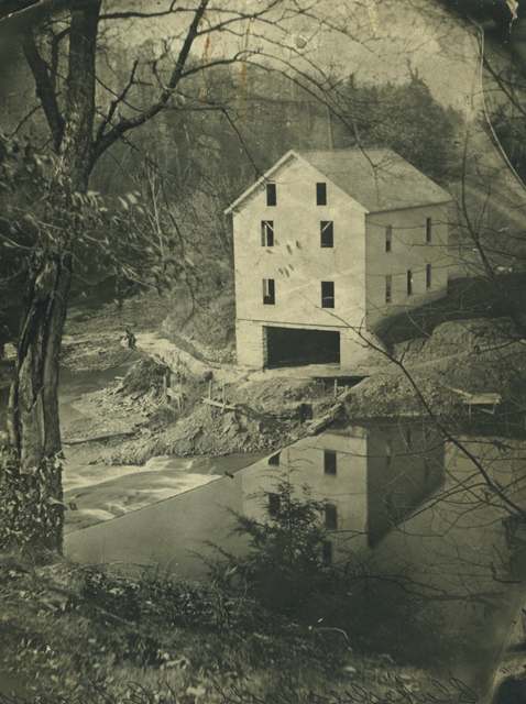
Photo: Unknown photographer, Cleveland Historical archives, public domain · Wikimedia Commons
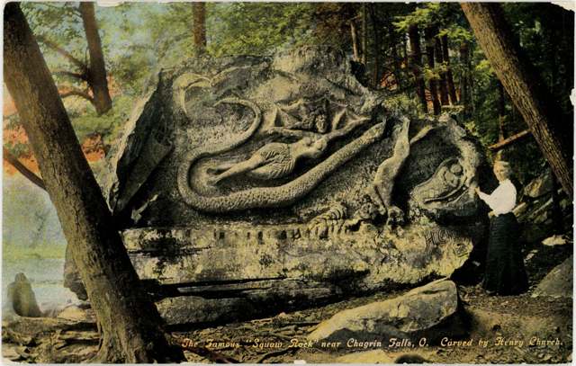
Photo: Columbus Metropolitan Library, via Digital Public Library of America / Ohio Digital Network, public domain · Wikimedia Commons
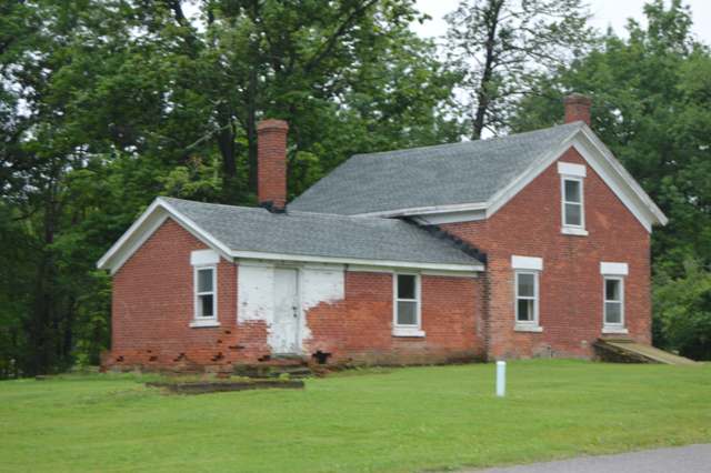
Photo: Nyttend (Wikimedia Commons), public domain · Wikimedia Commons
Local history sources: en.wikipedia.org · case.edu · clevelandhistorical.org · clevelandmetroparks.com · commons.wikimedia.org · commons.wikimedia.org · commons.wikimedia.org · commons.wikimedia.org · en.wikipedia.org
Historic places
2 places in Bentleyville on the National Register of Historic Places. Press a pin or a name for its whole record.
-
Look About LodgeBuilding · Bentleyville · listed 2006
- Address
- 37374 Miles Rd.
- Where
- Bentleyville, Cuyahoga County · ZIP 44022
- What it is
- Building
- Listed on the National Register
- 2006
- NRIS reference number
- 06000271
- Coordinates
- 41.42392, -81.42002
National Register file (NPS) ↗ Search Wikipedia ↗ Street map and directions ↗ On the Cracked Buckeye map
-
McFarland, Duncan, HouseBuilding · Bentleyville · listed 2001
- Address
- 35069 Cannon Rd.
- Where
- Bentleyville, Cuyahoga County · ZIP 44022
- What it is
- Building
- Listed on the National Register
- 2001
- NRIS reference number
- 01001258
- Coordinates
- 41.40919, -81.42307
National Register file (NPS) ↗ Search Wikipedia ↗ Street map and directions ↗ On the Cracked Buckeye map
Source: National Park Service, National Register of Historic Places point file. The listing year is shown where NPS's certification date agrees with the listing's reference number. Listing recognizes significance; it does not restrict a private owner.
Water
The Five Mile Crib, a small structure about 5 miles out in Lake Erie north of Cleveland's Edgewater Park The water here
- Cleveland Public Water System57% of residentsLake Erie
- Chagrin Falls Village36% of residentsLake Erie
- Paw Paw Lake6% of residentsGroundwater wells (2 wells)
Hospitals, fire stations and more
Inside Bentleyville's boundary: 1 poor-rated bridge, 1 museum and 1 police station. Press a pin or a name for its whole record and its source.
Bridges rated poor (1)
-
Chagrin River C102 over Deer Lick CreekPoor · built 1900
- Condition
- Poor: a deck, superstructure, substructure or culvert rated 4 or below on the 0 to 9 scale
- What it is
- Bridge
- Built
- 1900
- Length
- 31 ft
- Owner
- County
- Vehicles a day
- 768
- Coordinates
- 41.42347, -81.41845
National Bridge Inventory (source) ↗ Street map and directions ↗
Source: FHWA National Bridge Inventory 2025. "Poor" means one major part rated 4 or below on the 0 to 9 scale; it calls for repair, not closing, unless the state posts or closes the bridge.
Museums, historical societies, gardens and zoos (1)
-
Duncan Mcfarland HomesteadHistorical society · Chagrin Falls
- What it is
- Historical society
- City
- Chagrin Falls
- Coordinates
- 41.40868, -81.42223
Search Wikipedia ↗ IMLS Museum Data Files (source) ↗ Street map and directions ↗
The museum list is IMLS's 2018 file; a museum may have closed or moved since.
Source: IMLS Museum Data Files, 2018.
Police stations (1)
-
Bentleyville Police DepartmentBentleyville
- Address
- 6253 Chagrin River Road, Bentleyville, OH 44022
- Coordinates
- 41.41352, -81.41143
USGS National Map structures (source) ↗ Street map and directions ↗
Source: USGS National Map structures, police stations, corrected and completed by hand (September 2026). The department that answers a call is set by jurisdiction, not by distance.
Its ZIP codes
Each ZIP code that touches Bentleyville, with the share of its residents who live here and the same headline figures as the ZIP page.
| ZIP | Share | Water | Radon | Home value | Schools | Flood |
|---|---|---|---|---|---|---|
| 44022 Chagrin Falls | 5% | The Five Mile Crib, a small structure about 5 miles out in Lake Erie north of Cleveland's Edgewater Park | 2.6 pCi/L average radon | Median year built 1966 | Chagrin Falls Exempted Village · 5 stars overall | 0.8% of residents in the 1% floodplain |
Local government
Who holds office in Bentleyville, how its elections and ballot issues came out, and the state auditor's record.
Auditor of State record
- No fiscal caution, watch or emergency on the Auditor of State's lists.
- Agreed Upon Procedures, 2023 to 2024, released 2025-09-25
The county
Cuyahoga County: 52 ZIP codes, 59 cities, villages and townships, 1,270,867 people.
Nearby places
Rain and snow
How much has actually fallen on Bentleyville, day by day, from 1871 to now. Daily totals, not averages.
- rain, last 30 days
- 1.74 in
- 2026-09-29 to 2026-10-28
- rain so far in 2026
- 35.6 in
- about normal for the date
- snow so far in 2026
- 52.3 in
- a normal year brings 71.8 in
- a normal year
- 44.8 in
- average of 30 years, 1991-2020
| Month | Rain (in) | Snow (in) | Days counted |
|---|---|---|---|
| October 2026 | 1.74 | — | 28 |
| September 2026 | 3.10 | — | 30 |
| August 2026 | 7.05 | — | 31 |
| July 2026 | 2.98 | — | 31 |
| June 2026 | 2.54 | — | 30 |
| May 2026 | 4.37 | 0.3 | 31 |
| April 2026 | 6.64 | 0.2 | 30 |
| March 2026 | 3.60 | 2.3 | 31 |
| February 2026 | 1.01 | 11.3 | 28 |
| January 2026 | 2.60 | 38.3 | 31 |
| December 2025 | 2.87 | 18.1 | 31 |
| November 2025 | 2.38 | 13.3 | 30 |
| Wettest year | 2011 — 68.5 in |
|---|---|
| Driest year | 1934 — 25.3 in |
| Snowiest year | 2010 — 128.1 in |
| Wettest day on record | 14 September 1979 — 5.53 in |
| Heaviest snowfall in a day | 4 January 2010 — 15.55 in |
| Deepest snow on the ground | 5 January 2010 — 23.19 in |
Estimated, not measured. No rain gauge has ever stood inside Bentleyville, so every figure here is worked out from the gauges around it - the nearest ones weighted most. Treat them as close estimates rather than readings.
56,781 days of records, 1871-01-01 to 2026-10-28. Source: NOAA NCEI GHCN-Daily, 3,240 gauges in and around Ohio. A day is "gauged" when a gauge standing inside the boundary reported it, and the value is the mean of those gauges. Otherwise it is interpolated by inverse distance from every gauge reporting within 50 miles. Nothing is carried forward, back-filled or smoothed. Against NOAA nClimDiv county monthly precipitation over 136,848 complete county-months (checked 2026-10-31): correlation 0.9515, median absolute difference 0.217 in a month. Built 2026-10-31 from the Cracked Buckeye precipitation archive. Snow is the softer number — snowfall is measured by hand with a ruler, no agency publishes a gridded county snowfall series, and blowing snow defeats every observer.
Environmental permits and filings
What Ohio EPA has on file for Bentleyville: permits, inspections, violations, cleanups and the state loans behind sewer and water work. Every line links to the agency's own document.
- facilities and sites on file
- 2
- those placed on the map inside Bentleyville
| Program | Facilities and sites |
|---|---|
| Wetland and stream fill | 2 |
| Date | Facility or site | What |
|---|---|---|
| CMP CHAGRIN FALLS TRAIL PHASE 2 | Wetland and stream fill permit | |
| CMP CHAGRIN FALLS TRAIL PHASE 2 | Wetland and stream fill permit | |
| SOLON TO CHAGRIN FALLS TRAIL PHASE 2 PROJECT | Wetland and stream fill permit |
Source: Ohio EPA eDocument portal (edocpub.epa.ohio.gov), indexed 2026-10-14. Facilities are placed on the map from Ohio EPA's own map layers, EPA's Facility Registry, coordinates written in the filings, or a geocoded street address. A permit filed under a private person's name (most are household septic systems) is counted but never named, placed or linked; licenses for individual workers and open-burning notices are left out entirely.
Quick answers
What county is Bentleyville, Ohio in?
Bentleyville is a village in Cuyahoga County, Ohio, with 897 residents.
When was Bentleyville, Ohio founded?
Bentleyville was settled 1831 (Reverend Adamson Bentley buys land at the junction of the Aurora Branch and the Chagrin River); laid out 1831; incorporated 1928-29 (sources give both years), after residents circulated petitions and voted to secede from annexation proposals; originally part of Chagrin Falls Township. Founders on record: Reverend Adamson Bentley. Source
How did Bentleyville, Ohio get its name?
The village is named for its founder, Reverend Adamson Bentley, a Disciples of Christ minister who laid it out in 1831. Source
What ZIP code is Bentleyville, Ohio?
Most of Bentleyville is in ZIP code 44022.
Where does Bentleyville, Ohio get its water?
The main water source for Bentleyville (Cleveland Public Water System): The Five Mile Crib, a small structure about 5 miles out in Lake Erie north of Cleveland's Edgewater Park.
Cite this page
Cite this page as:
Cracked Buckeye, "Bentleyville, Cuyahoga County", https://crackedbuckeye.com/place/bentleyville/, built 2026-10-31, accessed [date].
How to cite · Report a correction · Built 2026-10-31
