Local events in Hanover Township, Butler County
Nothing is posted for Hanover Township itself yet; here is what is on within 10 miles. All local events in Hanover Township, Butler County
Know a calendar we should watch? Send the link
Checked October 20; the events page is refreshed daily.
Lakes near Hanover Township, Butler County
The history under the water: the valley before, the dam, the stories. All Ohio lakes
How Hanover Township, Butler County began
Hanover Township was organized December 2, 1811, the twelfth township formed in Butler County, carved from parts of Ross and St. Clair townships and named for Hanover County, Virginia, the home region of many of its early settlers. Lying midway between Hamilton and Oxford, the township's best-documented early landmark is the Matthew Hueston House, a stone farmhouse Hueston built himself between 1808 and 1813; Hueston went on to serve as a county commissioner and bank director. The Cincinnati, Hamilton and Dayton Railroad's Richmond division crossed the township with a station at McGonigle, a line still active today as part of CSX Transportation, and the city of Hamilton later annexed about four square miles from the township's original 36-square-mile eastern edge.
Incorporated 1811, by Division of Ross and St. Clair townships, the twelfth township organized in Butler County.
Where the name comes from
Hanover Township was named for Hanover County, Virginia, reflecting the origin of many of its early settlers.
Before the town
No Native village, trail, or burial site specifically within Hanover Township was found in the sources consulted. The Fortified Hill Works earthwork lies in neighboring Ross Township. Several NRHP-listed buildings that share this township's ZIP codes (45013 and 45056) -- the Anderson-Shaffer House, Beckett-Manrod House, Cochran Farm, Edgeton, Howell and Anna Powell Farm, John Scott Barn and Granary, Shaw Farm, Langstroth Cottage, the McGuffey House, the Alexander House, and the Dewitt Cabin -- belong instead to the city of Hamilton, Ross Township, or Oxford, which share those ZIP codes; only the Matthew Hueston House, confirmed by its own National Register documentation to sit at 1320 Four-Mile Creek Road in Hanover Township itself, is recorded here.
Timeline
- 19th century — The Cincinnati, Hamilton and Dayton Railroad's Richmond division crosses the township, with a station at McGonigle; the line remains active today as part of CSX Transportation.
- — Matthew Hueston builds his stone house on Four-Mile Creek Road, where he lives until the mid-1830s.
- — William Salmon sets up a distillery on the creek that bears his name; Hanover township's distilling runs from 1810 to 1830 with a dozen named distillers, many with grist mills attached.
- — Matthew Hueston's mill on Four Mile Creek is built by the millwright Joel Williams; Andrew Lewis teaches the first school about this year, in a log house near Bethel church.
- — Hanover Township is organized December 2 from parts of Ross and St. Clair townships, the twelfth township created in Butler County.
- — The first township election is held on December 21 at the house of Aaron Sackett; the township then had thirty-six sections and no village.
- — Ezekiel and Michael Ross build a tub-wheel grist mill and sawmill on Indian Creek, and the Samuel Zeigler Lutheran church is founded.
- — Deer and wild turkeys are still common in the township, along with wolves, foxes and raccoons.
- — A hewed-log school house is built in the central part of the township on the State road from Oxford to Hamilton.
- — Matthew Hueston serves as a Butler County commissioner, alongside earlier service as justice of the peace and later board positions with the Bank of Hamilton and the Miami Bridge Company.
- — Mount Zion Lutheran church is built, an offshoot of the Zeigler church after a creed dispute in 1842.
- — The county history notes that Hanover is a farming township with no village within its borders.
- — The Matthew Hueston House is listed on the National Register of Historic Places on September 16.
- — Township population reaches 8,111.
Stories
The commissioner who built his own house
Matthew Hueston began building his home on Four-Mile Creek Road in Hanover Township in 1808, working through five years of construction himself before finishing it in 1813: a simple rectangular stone house with a five-bay facade, a recessed central doorway, and six-over-six windows framed in wood and stone. Hueston was not just a farmer -- over the following decades he served as a justice of the peace, sat on the boards of the Bank of Hamilton and the Miami Bridge Company, and won election as a Butler County commissioner from 1826 to 1835, making his farmhouse the home of one of the township's more consequential early civic figures. He lived there until the mid-1830s, and the house, sometimes also called the Davidson House for a later owner, was listed on the National Register of Historic Places in 1977 -- a rare surviving link to Hanover Township's first generation of Virginia-descended settlers.
Whisky, mills and a road to Millville
Hanover Township had no village, and its earliest settlers were farmers, so its community life centered on mills and roads. Millville, just over the line in Ross Township, where Williams's mill stood, was the principal trading point for the south and west of Hanover, and the first road from Hamilton to Millville followed the township line, then wound along Indian Creek to Reily, one of the roads that connected with the border counties of Indiana. Matthew Hueston's mill, on Four Mile Creek, was built in 1809 by the millwright Joel Williams, who built at least half a dozen mills near Hamilton. From 1810 to 1830 the township was full of distilleries, from David Doner's on Kumler's run and William Salmon's of 1808 to those of the Moores, McGonigles, Martindales, Becketts, Yeakles, Willises and others, many tied to grist mills; the grain of the farms went out as whisky.
Photographs
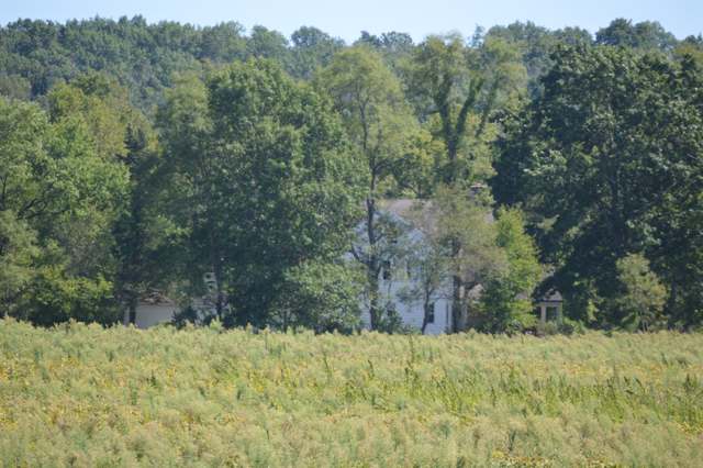
Photo: Nyttend, public domain · Wikimedia Commons
Local history sources: en.wikipedia.org · en.wikipedia.org · commons.wikimedia.org · archive.org
Historic places
2 places in Hanover Township, Butler County on the National Register of Historic Places. Press a pin or a name for its whole record.
-
Beckett-Manrod HouseBuilding · Hamilton · listed 1977
- Address
- 2019 Stillwell-Beckett Rd.
- Where
- Hamilton, Butler County · ZIP 45013
- What it is
- Building
- Listed on the National Register
- 1977
- NRIS reference number
- 77001044
- Coordinates
- 39.45293, -84.62837
National Register file (NPS) ↗ Search Wikipedia ↗ Street map and directions ↗ On the Cracked Buckeye map
-
Hueston, Matthew, HouseBuilding · Hamilton · listed 1977
- Address
- 1320 Four Mile Creek Rd.
- Where
- Hamilton, Butler County · ZIP 45013
- What it is
- Building
- Listed on the National Register
- 1977
- NRIS reference number
- 77001045
- Coordinates
- 39.46688, -84.60582
National Register file (NPS) ↗ Search Wikipedia ↗ Street map and directions ↗ On the Cracked Buckeye map
Source: National Park Service, National Register of Historic Places point file. The listing year is shown where NPS's certification date agrees with the listing's reference number. Listing recognizes significance; it does not restrict a private owner.
Water
Great Miami Buried Valley Aquifer, drawn from 16 production wells scattered through the City of Fairfield along the Great Miami River (river-induced infiltration), treated at the plant on River Road in Fairfield The water here
- Hamilton Public Water System58% of residentsGreat Miami Buried Valley Aquifer (wells)
- Southwest Regional Water District37% of residentsGreat Miami Buried Valley Aquifer (wells)
- Oxford City4% of residentsGreat Miami Buried Valley Aquifer (wells)
- New Miami Village2% of residentsGroundwater wells (3 wells)
- Cincinnati Public Water System0% of residentsOhio River (Miller Plant, ~88%) plus Great Miami Buried Valley Aquifer wells (~12%)
Hospitals, fire stations and more
Inside Hanover Township, Butler County's boundary: 1 nursing home, 1 fire or EMS station, 1 public school, 2 poor-rated bridges, 1 museum, 1 public charging site and 5 spill cases. Press a pin or a name for its whole record and its source.
Nursing homes (1)
-
Golden Years Nursing Center5 of 5 stars · Hamilton
- Address
- 2436 Old Oxford Road, Hamilton, OH 45013
- Certified beds
- 70
- Residents on an average day
- 68
- Medicare overall rating
- 5 of 5 stars
- Health inspections
- 5 of 5 stars
- Staffing
- 3 of 5 stars
- Quality measures
- 5 of 5 stars
- Penalties since 2023
- none
- Ownership
- For profit - Corporation
- Chain
- FOUNDATIONS HEALTH SOLUTIONS
- Takes
- Medicare and Medicaid
- Phone
- (513) 893-0471
- Medicare ID
- 366198
Medicare Care Compare ↗ CMS nursing home data (source) ↗ Street map and directions ↗
Source: CMS Care Compare nursing home provider and penalties files; Medicare star ratings run 1 to 5.
Fire and EMS stations (1)
-
Hanover Township Fire Department and Emergency Medical ServicesHamilton
- Address
- 1775 Morman Road, Hamilton, OH 45013
- Coordinates
- 39.43402, -84.64708
USGS National Map structures (source) ↗ Street map and directions ↗
Source: USGS National Map structures (most Ohio records last updated 2019 to 2022), checked against the Columbus and Cleveland station lists. The department that answers a call is set by jurisdiction and mutual aid, not by distance.
Public schools (1)
-
Maude Marshall Elementary School4 of 5 stars · Oxford
- Address
- 3260 Oxford Millville Rd, Oxford, OH 45056
- School district
- Talawanda City School District
- Kind (NCES)
- Regular School
- Students, 2023-24
- 350
- Teachers (full-time equivalent)
- 22
- Report card, 2025-26
- 4 of 5 stars
- Performance index
- 82.1%
- Ohio building IRN
- 023226
- NCES school ID
- 390461502456
NCES school record ↗ Ohio School Report Card ↗ Street map and directions ↗
Source: NCES EDGE public school locations 2024-25 and Common Core of Data 2023-24 (type, students, teachers); Ohio School Report Cards 2025-26 (Department of Education and Workforce), matched by name within the district.
Bridges rated poor (2)
-
Minton Rd over Beals Run CreekPoor · built 1974
- Condition
- Poor: a deck, superstructure, substructure or culvert rated 4 or below on the 0 to 9 scale
- What it is
- Bridge
- Built
- 1974
- Length
- 29 ft
- Owner
- County
- Vehicles a day
- 830
- Coordinates
- 39.40575, -84.65582
National Bridge Inventory (source) ↗ Street map and directions ↗
-
Nichols Rd over Curlane RunPoor · built 1973
- Condition
- Poor: a deck, superstructure, substructure or culvert rated 4 or below on the 0 to 9 scale
- What it is
- Bridge
- Built
- 1973
- Length
- 16 ft
- Owner
- County
- Vehicles a day
- 510
- Coordinates
- 39.47315, -84.69380
National Bridge Inventory (source) ↗ Street map and directions ↗
Source: FHWA National Bridge Inventory 2025. "Poor" means one major part rated 4 or below on the 0 to 9 scale; it calls for repair, not closing, unless the state posts or closes the bridge.
Museums, historical societies, gardens and zoos (1)
-
27Th Infantry Regimental Historical SocietyHistorical society · Oxford
- What it is
- Historical society
- City
- Oxford
- Coordinates
- 39.47799, -84.70153
Search Wikipedia ↗ IMLS Museum Data Files (source) ↗ Street map and directions ↗
The museum list is IMLS's 2018 file; a museum may have closed or moved since.
Source: IMLS Museum Data Files, 2018.
Public EV charging (1)
-
BUTLERRURALELEC BREC_HDQ2 Level 2 · Oxford
- Address
- 3888 Stillwell Beckett Rd, Oxford, OH 45056
- Ports
- 2 Level 2
- Plugs
- J1772
- Network
- ChargePoint Network
- Hours
- 24 hours daily
- Phone
- 888-758-4389
Station Locator (NREL) ↗ Alternative Fuels Data Center (source) ↗ Street map and directions ↗
Source: NREL Alternative Fuels Data Center station list (May 2026), public and open stations, the posts at one address counted as one site.
Spills reported since 2021 (5)
-
Grain (All Types) Agricultural2021-01-06 · St Clair Twp
- Reported
- 2021-01-06
- What spilled
- Grain (All Types) Agricultural
- Where
- St Clair Twp, NULL County
- Ohio EPA district office
- SWDO
- Ohio EPA case number
- 2101EPA0000035
Ohio EPA spill reports (source) ↗ Street map and directions ↗
-
Oil Transformer Non Pcb2026-08-14 · Hanover Twp
- Reported
- 2026-08-14
- What spilled
- Oil Transformer Non Pcb
- Largest amount reported
- 70 gallons
- Where
- Hanover Twp, Butler County
- Ohio EPA district office
- SWDO
- Ohio EPA case number
- 2608EPA0001507
Ohio EPA spill reports (source) ↗ Street map and directions ↗
-
Fuel Gasoline ( 25% Ethanol Not E85)2026-03-30 · Hanover Twp
- Reported
- 2026-03-30
- What spilled
- Fuel Gasoline ( 25% Ethanol Not E85); Oil Motor / Lube Oil / Vehicle
- Where
- Hanover Twp, Butler County
- Ohio EPA district office
- SWDO
- Ohio EPA case number
- 2603EPA0000524
Ohio EPA spill reports (source) ↗ Street map and directions ↗
-
Sheen Rainbow / Hydrocarbon Reached water2026-02-19 · Hanover Twp
- Reported
- 2026-02-19
- What spilled
- Sheen Rainbow / Hydrocarbon
- Reached a waterway
- 99 - Unnamed
- Where
- Hanover Twp, Butler County
- Ohio EPA district office
- SWDO
- Ohio EPA case number
- 2602EPA0000205
Ohio EPA spill reports (source) ↗ Street map and directions ↗
-
Sewage Human2026-02-04 · Hanover Twp
- Reported
- 2026-02-04
- What spilled
- Sewage Human
- Where
- Hanover Twp, Butler County
- Ohio EPA district office
- SWDO
- Ohio EPA case number
- 2602EPA0000131
Ohio EPA spill reports (source) ↗ Street map and directions ↗
Source: Ohio EPA emergency response spill reports, 2021 to September 2026, one point per case where Ohio EPA placed it. A report is what the caller or responder recorded; amounts are often blank or estimated.
Its ZIP codes
Each ZIP code that touches Hanover Township, Butler County, with the share of its residents who live here and the same headline figures as the ZIP page.
Local government
Who holds office in Hanover Township, Butler County, how its elections and ballot issues came out, and the state auditor's record.
Who holds office
| Office | Name | Party | Term ends | Contact |
|---|---|---|---|---|
| Township Fiscal Officer | Greg L. Sullivan | 11/2/2027 | ||
| Township Trustee | Larry Miller | 11/2/2027 | ||
| Township Trustee | Douglas L. Johnson | 11/6/2029 | ||
| Township Trustee | Diana Ramsey | 11/6/2029 |
Roster as of 2026-07-27: county board of elections.
The county
Butler County: 13 ZIP codes, 22 cities, villages and townships, 382,868 people.
Nearby places
Quick answers
What county is Hanover Township, Ohio in?
Hanover Township, Butler County is a township in Butler County, Ohio, with 7,913 residents.
When was Hanover Township, Ohio founded?
Hanover Township, Butler County was incorporated 1811. Founders on record: Division of Ross and St. Clair townships, the twelfth township organized in Butler County. Source
How did Hanover Township, Ohio get its name?
Hanover Township was named for Hanover County, Virginia, reflecting the origin of many of its early settlers. Source
What ZIP code is Hanover Township, Ohio?
Most of Hanover Township, Butler County is in ZIP code 45013.
Where does Hanover Township, Ohio get its water?
The main water source for Hanover Township, Butler County (Hamilton Public Water System): Great Miami Buried Valley Aquifer, drawn from 16 production wells scattered through the City of Fairfield along the Great Miami River (river-induced infiltration), treated at the plant on River Road in Fairfield.
Cite this page
Cite this page as:
Cracked Buckeye, "Hanover Township, Butler County", https://crackedbuckeye.com/place/hanover-township-butler-county/, built 2026-10-31, accessed [date].
How to cite · Report a correction · Built 2026-10-31
