Local events in Elizabeth Township, Lawrence County
Nothing is posted for Elizabeth Township itself yet; here is what is on within 20 miles. All local events in Elizabeth Township, Lawrence County
Know a calendar we should watch? Send the link
Checked October 20; the events page is refreshed daily.
How Elizabeth Township, Lawrence County began
Elizabeth Township, in western Lawrence County, is best known for Vesuvius Furnace, built in 1833 as one of the first charcoal iron blast furnaces of the Hanging Rock Iron Region and now the centerpiece of the Vesuvius Recreation Area within Wayne National Forest. The unincorporated communities of Etna and Pedro lie in the township's eastern section, and Ohio State University's sixth president, George Washington Rightmire, was born here.
Where the name comes from
The origin of the township's name is not recorded.
Before the town
No Native village, mound, trail or treaty event is recorded for Elizabeth Township. The township lies within the Ohio River lands ceded at the 1795 Treaty of Greenville.
Nations recorded here: Shawnee.
Timeline
- — Vesuvius Furnace is built, one of the first iron blast furnaces in the Hanging Rock Iron Region, running on charcoal fuel and a cold-air blast.
- — The hot-blast process, first tried in America at Vesuvius Furnace and installed by William Firmstone, was adopted in the Hanging Rock region; Willard's 1916 history dates the Vesuvius test to 1837, while the furnace's own National Archives caption gives 1836.
- — Elizabeth Township had 1,534 residents; it grew to 2,529 in 1850 and 2,730 in 1860.
- — Elizabeth Township had post offices at Kelley's Mills and Willow Grove.
- — The census counted 3,369 residents, the count then fell to 2,879 in 1900 and 2,787 in 1910.
- — The Civilian Conservation Corps completed the Vesuvius Recreational Area on the old furnace grounds, eight miles north of Ironton, with a lake and part of 4,000 acres of Wayne National Forest.
- — Vesuvius Furnace is added to the National Register of Historic Places (June 14).
- — A boundary decrease amendment is recorded for the Vesuvius Furnace listing, covering an associated stone bridge (September 15).
- — The census counted 2,527 residents in the 52.4-square-mile township.
Stories
A furnace stack that outlasted the district it lit
Vesuvius Furnace went up in 1833 as one of the earliest works of the Hanging Rock Iron Region, a stone stack fired with charcoal and run, at first, on a cold-air blast -- the older, less efficient technology that the hot-blast process would replace regionwide within a few years. The stack stands in what is now Elizabeth Township. In the twentieth century the Civilian Conservation Corps and the Forest Service built the Vesuvius Recreation Area, with a lake and picnic grounds in Wayne National Forest, around the old furnace.
The first hot blast in America
In 1837 several iron masters of the Hanging Rock region met at Vesuvius Furnace and agreed to test the new hot blast, a method of heating the air blown into a furnace. They hired William Firmstone to put one up at Vesuvius; if it worked, Hurd, Gould and Company, the furnace's owners, would pay the whole cost, and if it failed the expense would be divided among the iron masters. John Campbell and three others guaranteed against loss. The result was so successful that it marked a great step in the industry. Campbell, who laid out Ironton in 1849, afterward placed the boilers and hot blast over the tunnel head to use the waste gases, and he named Ironton's first street, next to Storms Creek, for Vesuvius, his favorite furnace. The old Vesuvius Furnace was in the end the only charcoal furnace still running on the cold-blast principle north of Tennessee and west of the Alleghenies when it closed.
Photographs
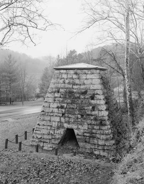
Photo: Jeff Bates, Library of Congress HAER survey, public domain · Wikimedia Commons
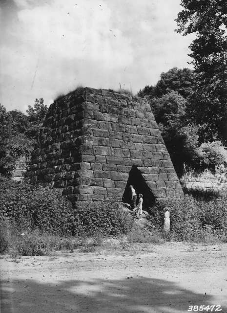
Photo: USDA Forest Service, Region 9; National Archives and Records Administration (NARA 2128436), public domain · Wikimedia Commons
Local history sources: en.wikipedia.org · en.wikipedia.org · commons.wikimedia.org · commons.wikimedia.org · en.wikipedia.org · archive.org · archive.org
Historic places
2 places in Elizabeth Township, Lawrence County on the National Register of Historic Places. Press a pin or a name for its whole record.
-
Vesuvius FurnaceStructure · Ironton · listed 1990
- Address
- Co. Hwy. 29 at Storms Creek in Vesuvius Recreation Area of Wayne National Forest
- Where
- Ironton, Lawrence County · ZIP 45659
- What it is
- Structure
- Listed on the National Register
- 1990
- NRIS reference number
- 89001714
- Coordinates
- 38.60546, -82.63008
National Register file (NPS) ↗ Search Wikipedia ↗ Street map and directions ↗ On the Cracked Buckeye map
-
Vesuvius Furnace--Stone Bridge (Boundary Decrease)Structure · Ironton · listed 2011
- Address
- Vesuvius Recreation Area off OH 93
- Where
- Ironton, Lawrence County · ZIP 45659
- What it is
- Structure
- Listed on the National Register
- 2011
- NRIS reference number
- 11000671
- Coordinates
- 38.60477, -82.63073
National Register file (NPS) ↗ Search Wikipedia ↗ Street map and directions ↗ On the Cracked Buckeye map
Source: National Park Service, National Register of Historic Places point file. The listing year is shown where NPS's certification date agrees with the listing's reference number. Listing recognizes significance; it does not restrict a private owner.
Water
Ohio River surface water, treated at the Ironton Water Treatment Plant (built 1993, approved capacity 4 million gallons per day, about 1.3 MGD produced). The foot-of-Vernon-Street siting describes the original 1872 waterworks, not the current intake location. The water here
- Hecla Water Association66% of residentsOhio River
- Ironton27% of residentsOhio River
- Coal Grove6% of residentsGroundwater wells (3 wells)
- Scioto Water Inc.-sugar Camp1% of residentsGroundwater wells (6 wells)
- Portsmouth City0% of residentsOhio River
Hospitals, fire stations and more
Inside Elizabeth Township, Lawrence County's boundary: 2 fire and EMS stations, 2 high-hazard dams, 3 public schools, 4 poor-rated bridges and 3 spill cases. Press a pin or a name for its whole record and its source.
Fire and EMS stations (2)
-
Elizabeth Township Volunteer Fire Department Station 1Pedro
- Address
- 127 Township Road 113, Pedro, OH 45659
- Coordinates
- 38.62778, -82.66645
USGS National Map structures (source) ↗ Street map and directions ↗
-
Elizabeth Township Volunteer Fire Department Station 2Ironton
- Address
- 4456 State Highway 650, Ironton, OH 45638
- Coordinates
- 38.60821, -82.70175
USGS National Map structures (source) ↗ Street map and directions ↗
Source: USGS National Map structures (most Ohio records last updated 2019 to 2022), checked against the Columbus and Cleveland station lists. The department that answers a call is set by jurisdiction and mutual aid, not by distance.
High-hazard dams (2)
-
Pine Creek Structure No. 8 DamTributary To Sperry Fork · condition: fair
- Hazard class
- High: a failure would probably cost a life
- Condition
- Fair (assessed 11/24/2020)
- River or stream
- Tributary To Sperry Fork
- Purpose
- Flood Risk Reduction
- Type
- Earth
- Height
- 36 ft
- Storage
- 613 acre-feet
- Completed
- 1972
- Owner type
- Local Government
- County
- Lawrence County
- Nearest town (NID)
- Pine Grove
- Last inspection
- 11/24/2020
- Emergency action plan
- No
- NID ID
- OH00703
National Inventory of Dams record ↗ National Inventory of Dams (source) ↗ Street map and directions ↗
-
Vesuvius DamStorms Creek · condition: not rated
- Hazard class
- High: a failure would probably cost a life
- Condition
- Not Rated
- River or stream
- Storms Creek
- Purpose
- Water Supply;Fish and Wildlife Pond;Recreation
- Type
- Earth
- Height
- 51 ft
- Storage
- 2,624 acre-feet
- Owner type
- Federal
- County
- Lawrence County
- Nearest town (NID)
- Ironton
- Last inspection
- 09/16/2019
- Emergency action plan
- Yes
- NID ID
- OH82424
National Inventory of Dams record ↗ National Inventory of Dams (source) ↗ Street map and directions ↗
Source: U.S. Army Corps of Engineers National Inventory of Dams, August 2026. "High hazard" rates what a failure would cost downstream, not how likely one is; the condition is the state's assessment.
Public schools (3)
-
Rock Hill Elementary School3 of 5 stars · Ironton
- Address
- 2676 County Road 26, Ironton, OH 45638
- School district
- Rock Hill Local School District
- Kind (NCES)
- Regular School
- Students, 2023-24
- 729
- Teachers (full-time equivalent)
- 52
- Report card, 2025-26
- 3 of 5 stars
- Performance index
- 74.8%
- Ohio building IRN
- 146464
- NCES school ID
- 390479404629
NCES school record ↗ Ohio School Report Card ↗ Street map and directions ↗
-
Rock Hill Middle School3 of 5 stars · Ironton
- Address
- 2171 County Road 26, Ironton, OH 45638
- School district
- Rock Hill Local School District
- Kind (NCES)
- Regular School
- Students, 2023-24
- 269
- Teachers (full-time equivalent)
- 28
- Report card, 2025-26
- 3 of 5 stars
- Performance index
- 67%
- Ohio building IRN
- 146472
- NCES school ID
- 390479404630
NCES school record ↗ Ohio School Report Card ↗ Street map and directions ↗
-
Rock Hill Sr High School3 of 5 stars · Ironton
- Address
- 2415 County Road 26, Ironton, OH 45638
- School district
- Rock Hill Local School District
- Kind (NCES)
- Regular School
- Students, 2023-24
- 320
- Teachers (full-time equivalent)
- 20
- Report card, 2025-26
- 3 of 5 stars
- Performance index
- 70%
- Four-year graduation rate
- 98.9%
- Ohio building IRN
- 146480
- NCES school ID
- 390479404631
NCES school record ↗ Ohio School Report Card ↗ Street map and directions ↗
Source: NCES EDGE public school locations 2024-25 and Common Core of Data 2023-24 (type, students, teachers); Ohio School Report Cards 2025-26 (Department of Education and Workforce), matched by name within the district.
Bridges rated poor (4)
-
County Road 29 over Unknown StreamPoor · built 1900
- Condition
- Poor: a deck, superstructure, substructure or culvert rated 4 or below on the 0 to 9 scale
- What it is
- Culvert
- Built
- 1900
- Length
- 7 ft
- Owner
- County
- Vehicles a day
- 374
- Coordinates
- 38.60606, -82.63664
National Bridge Inventory (source) ↗ Street map and directions ↗
-
Lawrence Hill Rd over Cranes Nest CreekPoor · built 1920
- Condition
- Poor: a deck, superstructure, substructure or culvert rated 4 or below on the 0 to 9 scale
- What it is
- Bridge
- Built
- 1920
- Length
- 12 ft
- Owner
- County
- Vehicles a day
- 209
- Coordinates
- 38.64279, -82.67478
National Bridge Inventory (source) ↗ Street map and directions ↗
-
Lawrence Hill Road over Cannons CreekPoor · built 1950
- Condition
- Poor: a deck, superstructure, substructure or culvert rated 4 or below on the 0 to 9 scale
- What it is
- Bridge
- Built
- 1950
- Length
- 9 ft
- Owner
- County
- Vehicles a day
- 209
- Coordinates
- 38.63482, -82.66977
National Bridge Inventory (source) ↗ Street map and directions ↗
-
Township Road 155 over Little Pine CreekPoor · built 1967
- Condition
- Poor: a deck, superstructure, substructure or culvert rated 4 or below on the 0 to 9 scale
- What it is
- Bridge
- Built
- 1967
- Length
- 23 ft
- Owner
- County
- Vehicles a day
- 13
- Coordinates
- 38.63271, -82.71446
National Bridge Inventory (source) ↗ Street map and directions ↗
Source: FHWA National Bridge Inventory 2025. "Poor" means one major part rated 4 or below on the 0 to 9 scale; it calls for repair, not closing, unless the state posts or closes the bridge.
Spills reported since 2021 (3)
-
Fish Kill2025-09-18 · Elizabeth Twp
- Reported
- 2025-09-18
- What spilled
- Fish Kill
- Where
- Elizabeth Twp, Lawrence County
- Ohio EPA district office
- SEDO
- Ohio EPA case number
- 2509EPA0001566
Ohio EPA spill reports (source) ↗ Street map and directions ↗
-
Fuel Diesel / Diesel Fuel (Vehicle On Or Off Road)2023-06-05 · Elizabeth Twp
- Reported
- 2023-06-05
- What spilled
- Fuel Diesel / Diesel Fuel (Vehicle On Or Off Road); Paint Nos / Lacquer (Not Specified)
- Largest amount reported
- 100 gallons
- Where
- Elizabeth Twp, Lawrence County
- Ohio EPA district office
- SEDO
- Ohio EPA case number
- 2306EPA0000923
Ohio EPA spill reports (source) ↗ Street map and directions ↗
-
Fuel Gasoline ( 25% Ethanol Not E85)2026-07-17 · Elizabeth Twp
- Reported
- 2026-07-17
- What spilled
- Fuel Gasoline ( 25% Ethanol Not E85); Oil Motor / Lube Oil / Vehicle
- Largest amount reported
- 4 gallons
- Where
- Elizabeth Twp, Lawrence County
- Ohio EPA district office
- SEDO
- Ohio EPA case number
- 2607EPA0001309
Ohio EPA spill reports (source) ↗ Street map and directions ↗
Source: Ohio EPA emergency response spill reports, 2021 to September 2026, one point per case where Ohio EPA placed it. A report is what the caller or responder recorded; amounts are often blank or estimated.
Its ZIP codes
Each ZIP code that touches Elizabeth Township, Lawrence County, with the share of its residents who live here and the same headline figures as the ZIP page.
Local government
Who holds office in Elizabeth Township, Lawrence County, how its elections and ballot issues came out, and the state auditor's record.
Elections for office
| Date | Office | Candidates and votes |
|---|---|---|
| 2021-11-02 | Township Trustee | Rickey Cox 269, 30.46%; George Mullins 161, 18.23%; Sadie Sparks 249, 28.2%; Kevin Wilds 204, 23.1% |
| 2021-11-02 | Township Fiscal Officer | Kathy Bamer 376, 100.0% |
| 2019-11-05 | Township Trustee | Shannon Summers 392, 55.52%; Steve J. Wilds 314, 44.48% |
| 2019-11-05 | Township Fiscal Officer | Melanie L. Mullins 475, 100.0% |
Winners in bold. Results from the county board of elections' official canvass unless marked.
Auditor of State record
- No fiscal caution, watch or emergency on the Auditor of State's lists.
- Financial Audit, 2022 to 2023, released 2024-08-22
The county
Lawrence County: 9 ZIP codes, 20 cities, villages and townships, 58,180 people.
Nearby places
Quick answers
What county is Elizabeth Township, Ohio in?
Elizabeth Township, Lawrence County is a township in Lawrence County, Ohio, with 2,527 residents.
How did Elizabeth Township, Ohio get its name?
The origin of the township's name is not recorded. Source
What ZIP code is Elizabeth Township, Ohio?
Elizabeth Township, Lawrence County is served by ZIP codes 45659 and 45638; 45659 holds the largest share of its residents.
Where does Elizabeth Township, Ohio get its water?
The main water source for Elizabeth Township, Lawrence County (Hecla Water Association): Ohio River surface water, treated at the Ironton Water Treatment Plant (built 1993, approved capacity 4 million gallons per day, about 1.3 MGD produced). The foot-of-Vernon-Street siting describes the original 1872 waterworks, not the current intake location.
Cite this page
Cite this page as:
Cracked Buckeye, "Elizabeth Township, Lawrence County", https://crackedbuckeye.com/place/elizabeth-township-lawrence-county/, built 2026-10-31, accessed [date].
How to cite · Report a correction · Built 2026-10-31
