Local events in Ironton
18 events in the next 90 days from 2 public calendars. All local events in Ironton
Checked October 20; the events page is refreshed daily.
Lakes near Ironton
The history under the water: the valley before, the dam, the stories. All Ohio lakes
History from Ironton
People and inventions tied to this place, each with its sources. All people · All inventions
How Ironton began
Ironton was founded in 1849 by pig-iron manufacturer John Campbell as a river-shipping point for the charcoal furnaces of the Hanging Rock Iron Region, its name a contraction of "iron town." Between 1850 and 1890 it became one of the foremost iron producers in the world, its metal bought by England, France, and Russia for warships and reportedly used in the Union ironclad USS Monitor, and it became the Lawrence County seat in 1851. The city was also a stop on the Underground Railroad and, from 1919 to 1930, home to the Ironton Tanks, whose Thanksgiving Day games helped establish the tradition later carried on by the Detroit Lions. Floods in 1917 and 1937 and the national shift from iron to steel ended the boom, and downtown Ironton's surviving 1870s-1950s commercial buildings are today a National Register historic district.
Platted 1849, by John Campbell, a pig-iron manufacturer, who sited the town on the Ohio River for shipping iron to downriver markets.
Where the name comes from
A contraction of "iron town," reflecting the city's founding purpose as a shipping and manufacturing point for the Hanging Rock Iron Region's charcoal furnaces.
Before the town
No source found records a Native village, mound, trail, or treaty event specific to the site of Ironton, which was not founded until 1849, six decades after the 1795 Treaty of Greenville placed this stretch of the Ohio River within land ceded by the Wyandot, Shawnee, and allied nations. The wider county's Native history -- Shawnee and Mingo presence in the lower Ohio Valley, and the absence of a documented county-specific site -- is covered at the county level.
Nations recorded here: Shawnee.
Timeline
- — John Campbell founds Ironton on the Ohio River as a shipping point for the Hanging Rock Iron Region's pig iron.
- — Ironton becomes the Lawrence County seat, taking the role from Burlington.
- — Ironton is one of the foremost iron producers in the world; England, France, and Russia buy its iron for warships, and it is reportedly used in the Union ironclad USS Monitor, with more than 90 furnaces operating in the surrounding region at peak production.
- — The Grand Army of the Republic Memorial Hall is built at 401 Railroad Street, designed by architect Joseph W. Yost in the Richardsonian Romanesque style, as a meeting hall for Civil War veterans of Dick Lambert Post No. 165.
- — The F.W. Erlich House is built at 1908 S. Sixth Street in the Queen Anne style.
- — The Brumberg Building is built at 222 S. Third Street; the Norfolk and Western Railway also builds a new downtown station this year, which remains in operation into the mid-20th century.
- — The Marting Hotel is built at 202 Park Avenue; the same year, a major Ohio River flood damages the city.
- — The Ironton Tanks, one of the country's first professional football teams, play their home games in the city; their 1920s Thanksgiving Day games against rivals such as the Huntington Boosters helped establish the tradition the Detroit Lions later carried into the NFL.
- — The Selby Shoe Company Building is built at 1603 S. Third Street.
- — A second catastrophic Ohio River flood, striking during the Great Depression, devastates Ironton's industries and infrastructure.
- — The Downtown Ironton Historic District, covering roughly 13 acres of 2nd through 5th Streets and Park Avenue with buildings dating from the 1870s to the 1950s, is added to the National Register of Historic Places.
- — The 1892 GAR Memorial Hall, despite its 2012 National Register listing, is demolished on May 28 after years of deterioration that included a collapsed roof.
Stories
The city iron built, and the flood that helped unbuild it
John Campbell chose the site in 1849 for one reason: the Ohio River could carry his pig iron to market. For forty years the bet paid off spectacularly -- Ironton's furnaces supplied warship iron to England, France, and Russia, and iron from the surrounding Hanging Rock Iron Region reportedly went into the Union's ironclad USS Monitor during the Civil War, while more than ninety furnaces smoked across the district at the industry's peak. The same river that built the city eventually helped unbuild it. A major flood struck in 1917, and a second, far worse flood arrived in 1937 in the depths of the Great Depression, just as the national iron trade was already losing ground to steel made elsewhere. Between the flood damage and the industrial shift, Ironton's furnaces closed one after another, and the city never fully replaced the jobs they had provided.
A memorial hall that outlived its cause but not itself
In 1892, architect Joseph W. Yost designed a Richardsonian Romanesque meeting hall at 401 Railroad Street for Dick Lambert Post No. 165 of the Grand Army of the Republic, the Union Civil War veterans' organization. As the aging veterans died off, American Legion Post No. 59 took over the building, and later the city of Ironton itself used it for municipal offices before finally abandoning it. Legion Post No. 433 tried to restore the deteriorating hall, and in September 2012 the effort paid off on paper: the building was added to the National Register of Historic Places. It made no difference to the building's fate. By 2014 the roof had collapsed and the structure was beyond saving; demolition began on May 28 of that year, ending the 122-year-old hall's life just two years after its highest formal honor.
Thanksgiving football, before it belonged to Detroit
The Ironton Tanks organized in 1919 and played through 1930, one of the earliest professional football teams in the country and a point of fierce local pride during the city's industrial peak. The Tanks made a habit of playing on Thanksgiving weekend against crosstown and regional rivals -- a loss to the Lombards the day after Thanksgiving in 1920, a 12-0 win over the Huntington Boosters on Thanksgiving Day itself in 1922 -- and kept the tradition every year through their final 1930 season. The custom the small-city Tanks built did not end with them: it is credited as the origin of the National Football League's Thanksgiving Day Game tradition later carried on by the Detroit Lions, a legacy that has long outlasted the team and the iron industry that supported it.
Photographs
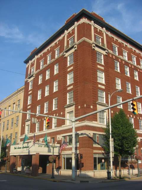
Photo: Nyttend, public domain · Wikimedia Commons
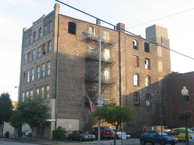
Photo: Nyttend, public domain · Wikimedia Commons
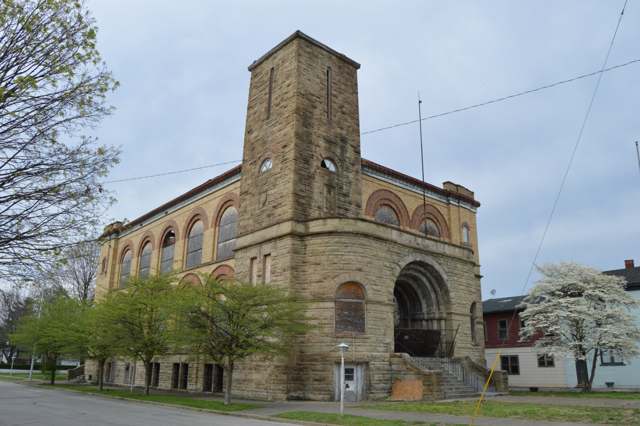
Photo: Nyttend, public domain · Wikimedia Commons
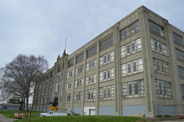
Photo: Nyttend, public domain · Wikimedia Commons
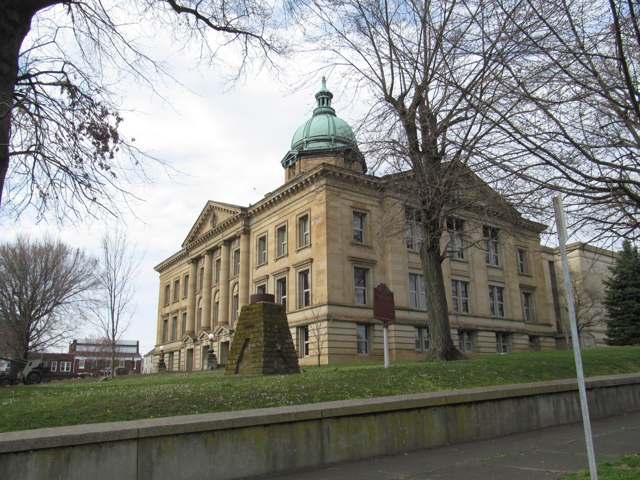
Photo: Doug Kerr, CC BY-SA 2.0 · Wikimedia Commons
Local history sources: en.wikipedia.org · en.wikipedia.org · en.wikipedia.org · en.wikipedia.org · en.wikipedia.org · commons.wikimedia.org · commons.wikimedia.org · commons.wikimedia.org · commons.wikimedia.org · commons.wikimedia.org · commons.wikimedia.org · en.wikipedia.org
Historic places
7 places in Ironton on the National Register of Historic Places. Press a pin or a name for its whole record.
-
Brumberg BuildingBuilding · Ironton · listed 2008
- Address
- 222 S. 3rd St.
- Where
- Ironton, Lawrence County · ZIP 45638
- What it is
- Building
- Listed on the National Register
- 2008
- NRIS reference number
- 08000148
- Coordinates
- 38.53378, -82.68471
National Register file (NPS) ↗ Search Wikipedia ↗ Street map and directions ↗ On the Cracked Buckeye map
-
Erlich, F. W., HouseBuilding · Ironton · listed 1980
- Address
- 1908 S. 6th St.
- Where
- Ironton, Lawrence County · ZIP 45638
- What it is
- Building
- Listed on the National Register
- 1980
- NRIS reference number
- 80003134
- Coordinates
- 38.52145, -82.67028
National Register file (NPS) ↗ Search Wikipedia ↗ Street map and directions ↗ On the Cracked Buckeye map
-
Grand Army of the Republic Memorial HallBuilding · Ironton · listed 2012
- Address
- 401 Railroad St.
- Where
- Ironton, Lawrence County · ZIP 45638
- What it is
- Building
- Listed on the National Register
- 2012
- NRIS reference number
- 12000801
- Coordinates
- 38.53736, -82.68533
National Register file (NPS) ↗ Search Wikipedia ↗ Street map and directions ↗ On the Cracked Buckeye map
-
Marlow TheatreBuilding · Ironton · listed 2008
- Address
- S. 3rd & Park Sts.
- Where
- Ironton, Lawrence County · ZIP 45638
- What it is
- Building
- Listed on the National Register
- 2008
- NRIS reference number
- 08000149
- Coordinates
- 38.53422, -82.68512
National Register file (NPS) ↗ Search Wikipedia ↗ Street map and directions ↗ On the Cracked Buckeye map
-
Marting HotelBuilding · Ironton · listed 1999
- Address
- 202 Park Av.
- Where
- Ironton, Lawrence County · ZIP 45638
- What it is
- Building
- Listed on the National Register
- 1999
- NRIS reference number
- 99000331
- Coordinates
- 38.53402, -82.68583
National Register file (NPS) ↗ Search Wikipedia ↗ Street map and directions ↗ On the Cracked Buckeye map
-
Norfolk And Western Railroad DepotBuilding · Ironton · listed 1978
- Address
- 1st St. and Park Ave.
- Where
- Ironton, Lawrence County · ZIP 45638
- What it is
- Building
- Listed on the National Register
- 1978
- NRIS reference number
- 78002099
- Coordinates
- 38.53420, -82.68640
National Register file (NPS) ↗ Search Wikipedia ↗ Street map and directions ↗ On the Cracked Buckeye map
-
Selby Shoe Company BuildingBuilding · Ironton · listed 2009
- Address
- 1603 S. 3rd St.
- Where
- Ironton, Lawrence County · ZIP 45638
- What it is
- Building
- Listed on the National Register
- 2009
- NRIS reference number
- 09000444
- Coordinates
- 38.52288, -82.67514
National Register file (NPS) ↗ Search Wikipedia ↗ Street map and directions ↗ On the Cracked Buckeye map
Source: National Park Service, National Register of Historic Places point file. The listing year is shown where NPS's certification date agrees with the listing's reference number. Listing recognizes significance; it does not restrict a private owner.
Water
Ohio River surface water, treated at the Ironton Water Treatment Plant (built 1993, approved capacity 4 million gallons per day, about 1.3 MGD produced). The foot-of-Vernon-Street siting describes the original 1872 waterworks, not the current intake location. The water here
- Ironton64% of residentsOhio River
- Hecla Water Association21% of residentsOhio River
- Coal Grove15% of residentsGroundwater wells (3 wells)
- Scioto Water Inc.-sugar Camp1% of residentsGroundwater wells (6 wells)
Hospitals, fire stations and more
Inside Ironton's boundary: 5 health centers, 1 dialysis center, 2 nursing homes, 1 fire or EMS station, 1 college, 3 public schools, 2 private schools, 1 poor-rated bridge, 1 library, 2 museums, 2 police stations, 1 public charging site, 3 Superfund sites, 3 Toxics Release Inventory facilities and 4 spill cases. Press a pin or a name for its whole record and its source.
Community health centers (5)
-
Ironton Health Care CampusHealth center · Ironton
- Run by
- a federally qualified health center
- Setting
- Clinic
- City
- Ironton
- Coordinates
- 38.52656, -82.66198
Find a Health Center (HRSA) ↗ HRSA data (source) ↗ Street map and directions ↗
-
Ironton-Lawrence County Community Action Organization, Inc.Health center · Ironton
- Run by
- a federally qualified health center
- Setting
- Clinic
- City
- Ironton
- Coordinates
- 38.53862, -82.68480
Find a Health Center (HRSA) ↗ HRSA data (source) ↗ Street map and directions ↗
-
Kennedy BuildingHealth center · Ironton
- Run by
- a federally qualified health center
- Setting
- Clinic
- City
- Ironton
- Coordinates
- 38.53821, -82.68498
Find a Health Center (HRSA) ↗ HRSA data (source) ↗ Street map and directions ↗
-
Nancy's PlaceHealth center · Ironton
- Run by
- a federally qualified health center
- Setting
- Clinic
- City
- Ironton
- Coordinates
- 38.53582, -82.68586
Find a Health Center (HRSA) ↗ HRSA data (source) ↗ Street map and directions ↗
-
One Stop Family Medical CenterHealth center · Ironton
- Run by
- a federally qualified health center
- Setting
- Clinic
- City
- Ironton
- Coordinates
- 38.53612, -82.68642
Find a Health Center (HRSA) ↗ HRSA data (source) ↗ Street map and directions ↗
Source: HRSA health center service delivery sites, active, September 2026 (school-based sites left out). Health centers see patients whether or not they have insurance, with fees on a sliding scale.
Dialysis centers (1)
-
Fmc - IrontonDialysis · Ironton
- Address
- 158 N 2Nd Street, Ironton, OH 45638
- Dialysis stations
- 16
- Medicare star rating
- 3 of 5 stars
- Services
- in-center hemodialysis
- Ownership
- for profit
- Chain
- Fresenius Medical Care
- Medicare certified since
- 2011-07-13
- Phone
- (740) 532-3099
- Medicare ID
- 362770
Medicare Care Compare ↗ CMS dialysis facility list (source) ↗ Street map and directions ↗
Source: CMS dialysis facility list, September 2026, geocoded with the Census Bureau batch geocoder (an address it could not place sits at its ZIP center).
Nursing homes (2)
-
Harbor Healthcare of Ironton4 of 5 stars · Ironton
- Address
- 1050 Clinton Street, Ironton, OH 45638
- Certified beds
- 125
- Residents on an average day
- 115
- Medicare overall rating
- 4 of 5 stars
- Health inspections
- 3 of 5 stars
- Staffing
- 2 of 5 stars
- Quality measures
- 5 of 5 stars
- Penalties since 2023
- none
- Ownership
- For profit - Corporation
- Chain
- ECC TRUST
- Takes
- Medicare and Medicaid
- Phone
- (740) 532-6096
- Medicare ID
- 365564
Medicare Care Compare ↗ CMS nursing home data (source) ↗ Street map and directions ↗
-
Sanctuary at Ohio Valley4 of 5 stars · Ironton
- Address
- 2932 South 5Th Street, Ironton, OH 45638
- Certified beds
- 93
- Residents on an average day
- 77
- Medicare overall rating
- 4 of 5 stars
- Health inspections
- 4 of 5 stars
- Staffing
- 3 of 5 stars
- Quality measures
- 4 of 5 stars
- Penalties since 2023
- none
- Ownership
- Non profit - Corporation
- Chain
- AMERICAN HEALTH FOUNDATION
- Takes
- Medicare and Medicaid
- Phone
- (740) 532-6188
- Medicare ID
- 365791
Medicare Care Compare ↗ CMS nursing home data (source) ↗ Street map and directions ↗
Source: CMS Care Compare nursing home provider and penalties files; Medicare star ratings run 1 to 5.
Fire and EMS stations (1)
-
Ironton Fire DepartmentIronton
- Address
- 526 South 4th Street, Ironton, OH 45638
- Coordinates
- 38.53214, -82.68180
USGS National Map structures (source) ↗ Street map and directions ↗
Source: USGS National Map structures (most Ohio records last updated 2019 to 2022), checked against the Columbus and Cleveland station lists. The department that answers a call is set by jurisdiction and mutual aid, not by distance.
Colleges (1)
-
Ohio University-Southern CampusRegional campus of a public university · Ironton
- What it is
- Regional campus of a public university
- City
- Ironton
- Students, 2023-24 (12-month count)
- 3,347
- Tuition and fees, in state
- $6,178
- Tuition and fees, out of state
- $9,170
- Graduation rate
- 19% of bachelor's students, within six years (a class of 112)
- IPEDS unit ID
- 204839
College Navigator (NCES) ↗ IPEDS data (source) ↗ Street map and directions ↗
Source: NCES IPEDS 2024 directory, 2023-24 enrollment and tuition, graduation rates for the 2017 (four-year) and 2020 (two-year) entering classes.
Public schools (3)
-
Ironton Elementary School3 of 5 stars · Ironton
- Address
- 302 Delaware St, Ironton, OH 45638
- School district
- Ironton City School District
- Kind (NCES)
- Regular School
- Students, 2023-24
- 622
- Teachers (full-time equivalent)
- 32
- Report card, 2025-26
- 3 of 5 stars
- Performance index
- 69.7%
- Ohio building IRN
- 041186
- NCES school ID
- 390441401072
NCES school record ↗ Ohio School Report Card ↗ Street map and directions ↗
-
Ironton High School4 of 5 stars · Ironton
- Address
- 1701 S 7th St, Ironton, OH 45638
- School district
- Ironton City School District
- Kind (NCES)
- Regular School
- Students, 2023-24
- 418
- Teachers (full-time equivalent)
- 21
- Report card, 2025-26
- 4 of 5 stars
- Performance index
- 80.8%
- Four-year graduation rate
- 99.2%
- Ohio building IRN
- 017491
- NCES school ID
- 390441401069
NCES school record ↗ Ohio School Report Card ↗ Street map and directions ↗
-
Ironton Middle School3 of 5 stars · Ironton
- Address
- 302 Delaware St, Ironton, OH 45638
- School district
- Ironton City School District
- Kind (NCES)
- Regular School
- Students, 2023-24
- 308
- Teachers (full-time equivalent)
- 19
- Report card, 2025-26
- 3 of 5 stars
- Performance index
- 72.2%
- Ohio building IRN
- 004713
- NCES school ID
- 390441400359
NCES school record ↗ Ohio School Report Card ↗ Street map and directions ↗
Source: NCES EDGE public school locations 2024-25 and Common Core of Data 2023-24 (type, students, teachers); Ohio School Report Cards 2025-26 (Department of Education and Workforce), matched by name within the district.
Private schools (2)
-
St Joseph High SchoolPrivate, Catholic · Ironton
- Address
- 912 S 6Th St, Ironton, OH 45638
- Kind
- Catholic
- Students, 2023-24
- 59
- Teachers (full-time equivalent)
- 10.8
- Students per teacher
- 5.46296
- Phone
- (740) 532-0485
- NCES private school ID
- A9105249
-
St Lawrence SchoolPrivate, Catholic · Ironton
- Address
- 315 S 6Th St, Ironton, OH 45638
- Kind
- Catholic
- Students, 2023-24
- 93
- Teachers (full-time equivalent)
- 11
- Students per teacher
- 8.45455
- Phone
- (740) 532-5052
- NCES private school ID
- 01060499
Source: NCES Private School Survey 2023-24.
Bridges rated poor (1)
-
North 5th Street over Storms CreekPoor · built 1900
- Condition
- Poor: a deck, superstructure, substructure or culvert rated 4 or below on the 0 to 9 scale
- What it is
- Bridge
- Built
- 1900
- Length
- 39 ft
- Owner
- City
- Vehicles a day
- 100
- Coordinates
- 38.54776, -82.69341
National Bridge Inventory (source) ↗ Street map and directions ↗
Source: FHWA National Bridge Inventory 2025. "Poor" means one major part rated 4 or below on the 0 to 9 scale; it calls for repair, not closing, unless the state posts or closes the bridge.
Public libraries (1)
-
Briggs Lawrence County Public LibraryCentral library · Ironton
- Address
- 321 S. 4Th St., Ironton, OH 45638
- What it is
- Central library
- Library system
- Briggs Lawrence County Public Library
- Open
- 2,808 hours a year, 52 weeks
- Building
- 18,000 sq ft
- System's visits, FY2024
- 81,432
- System's loans, FY2024
- 236,393
- People the system serves
- 58,066
- Phone
- (740) 532-1124
IMLS Public Libraries Survey (source) ↗ Street map and directions ↗
Source: IMLS Public Libraries Survey FY2024 (outlets and their systems). Any Ohio resident can get a free card at any Ohio public library.
Museums, historical societies, gardens and zoos (2)
-
Lawrence County Historical SocietyHistorical society · Ironton
- What it is
- Historical society
- City
- Ironton
- Coordinates
- 38.53375, -82.67985
Search Wikipedia ↗ IMLS Museum Data Files (source) ↗ Street map and directions ↗
The museum list is IMLS's 2018 file; a museum may have closed or moved since.
-
Monument PreservationHistorical society · Ironton
- What it is
- Historical society
- City
- Ironton
- Coordinates
- 38.51538, -82.66640
Search Wikipedia ↗ IMLS Museum Data Files (source) ↗ Street map and directions ↗
The museum list is IMLS's 2018 file; a museum may have closed or moved since.
Source: IMLS Museum Data Files, 2018.
Police stations (2)
-
Ironton Police DepartmentIronton
- Address
- 301 South 3rd Street, Ironton, OH 45638
- Coordinates
- 38.53374, -82.68411
USGS National Map structures (source) ↗ Street map and directions ↗
-
Lawrence County Sheriff's OfficeIronton
- Address
- 115 South 5th Street, Ironton, OH 45638
- Coordinates
- 38.53623, -82.68281
USGS National Map structures (source) ↗ Street map and directions ↗
Source: USGS National Map structures, police stations, corrected and completed by hand (September 2026). The department that answers a call is set by jurisdiction, not by distance.
Public EV charging (1)
-
Glockner of Ironton DC fast1 DC fast · Ironton
- Address
- 911 S. 3rd St, Ironton, OH 45638
- Ports
- 1 DC fast
- Plugs
- CCS
- Network
- EV Connect
- Hours
- 24 hours daily
- Phone
- 866-816-7584
Station Locator (NREL) ↗ Alternative Fuels Data Center (source) ↗ Street map and directions ↗
Source: NREL Alternative Fuels Data Center station list (May 2026), public and open stations, the posts at one address counted as one site.
Superfund sites (3)
-
Allied Chemical & Ironton Coke NPLSuperfund, NPL · Ironton
- Address
- 3330 South 3Rd Street, Ironton, OH 45638
- County
- Lawrence County
- Status
- On the National Priorities List
- EPA program ID
- OHD043730217
- EPA registry ID
- 110000395199
EPA facility record ↗ EPA Facility Registry Service (source) ↗ Street map and directions ↗
-
Tiger MetalsSuperfund program · Ironton
- Address
- 1100 S 2Nd St, Ironton, OH 45638
- County
- Lawrence County County
- Status
- Superfund program site, not on the National Priorities List
- EPA program ID
- OHD004294625
- EPA registry ID
- 110067846932
EPA facility record ↗ EPA Facility Registry Service (source) ↗ Street map and directions ↗
-
Tri-State Tank Cleaning IncorporatedSuperfund program · Coal Grove
- Address
- 510 Riverside Drive, Coal Grove, OH 45638
- County
- Lawrence County
- Status
- Superfund program site, not on the National Priorities List
- EPA program ID
- OHD009841214
- EPA registry ID
- 110071101192
EPA facility record ↗ EPA Facility Registry Service (source) ↗ Street map and directions ↗
Source: EPA Facility Registry Service, Superfund (SEMS) and National Priorities List sites. Many program sites were assessed and needed no cleanup.
Facilities reporting toxic releases (3)
-
Allied Chemical & Ironton CokeToxics Release Inventory · Ironton
- Address
- 3330 South 3Rd Street, Ironton, OH 45638
- County
- Lawrence County
- Status
- Reports to the Toxics Release Inventory (active)
- EPA program ID
- 45638LLDSG3330S
- EPA registry ID
- 110000395199
EPA facility record ↗ EPA Facility Registry Service (source) ↗ Street map and directions ↗
-
Intermet Ironton FoundryToxics Release Inventory · Ironton
- Address
- 2520 S. 3Rd St., Ironton, OH 45638
- County
- Lawrence County
- Status
- Reports to the Toxics Release Inventory (closed)
- EPA program ID
- 45638RNTNR2520S
- EPA registry ID
- 110000395206
EPA facility record ↗ EPA Facility Registry Service (source) ↗ Street map and directions ↗
-
Vertiv CorporationToxics Release Inventory · Ironton
- Address
- 3040 South Ninth Street, Ironton, OH 45638
- County
- Lawrence County
- Status
- Reports to the Toxics Release Inventory (active)
- EPA program ID
- 45638LBRTC3040S
- EPA registry ID
- 110004723103
EPA facility record ↗ EPA Facility Registry Service (source) ↗ Street map and directions ↗
Source: EPA Facility Registry Service, Toxics Release Inventory reporters. Reporting a release is required of large users of listed chemicals; it is not by itself a violation.
Spills reported since 2021 (4)
-
Waste Water Reached water2024-05-22 · Ironton
- Reported
- 2024-05-22
- What spilled
- Waste Water
- Reached a waterway
- 44 - Ohio River
- Where
- Ironton, Lawrence County
- Ohio EPA district office
- SEDO
- Ohio EPA case number
- 2405EPA0000858
Ohio EPA spill reports (source) ↗ Street map and directions ↗
-
Mercury / Quicksilver (Hg)2026-08-29 · Ironton
- Reported
- 2026-08-29
- What spilled
- Mercury / Quicksilver (Hg)
- Where
- Ironton, Lawrence County
- Ohio EPA district office
- SEDO
- Ohio EPA case number
- 2608EPA0001616
Ohio EPA spill reports (source) ↗ Street map and directions ↗
-
Material Undetermined / Other2026-08-23 · Ironton
- Reported
- 2026-08-23
- What spilled
- Material Undetermined / Other
- Where
- Ironton, Lawrence County
- Ohio EPA district office
- SEDO
- Ohio EPA case number
- 2608EPA0001583
Ohio EPA spill reports (source) ↗ Street map and directions ↗
-
Orphan Drum(S)2026-05-28 · Ironton
- Reported
- 2026-05-28
- What spilled
- Orphan Drum(S)
- Largest amount reported
- 220 gallons
- Where
- Ironton, Lawrence County
- Ohio EPA district office
- SEDO
- Ohio EPA case number
- 2605EPA0000924
Ohio EPA spill reports (source) ↗ Street map and directions ↗
Source: Ohio EPA emergency response spill reports, 2021 to September 2026, one point per case where Ohio EPA placed it. A report is what the caller or responder recorded; amounts are often blank or estimated.
Its ZIP codes
Each ZIP code that touches Ironton, with the share of its residents who live here and the same headline figures as the ZIP page.
Local government
How its elections and ballot issues came out and the state auditor's record.
Money issues on the ballot since 2019: 2 of 3 passed.
Ballot issues
| Date | Issue | For | Against | Result |
|---|---|---|---|---|
| 2022-11-08 | Issue: City of Ironton Tax Levy | 1,507 | 1,317 | Passed (53.36% for), unofficial |
| 2020-11-03 | Issue: City of Ironton Tax Levy Flood Protection | 2,380 | 2,191 | Passed (52.07% for) |
| 2019-11-05 | Issue: City of Ironton Municipal Income Tax | 712 | 2,198 | Failed (24.47% for) |
Elections for office
| Date | Office | Candidates and votes |
|---|---|---|
| 2021-11-02 | Member of Council | Bob Cleary 743, 15.3%; Craig Harvey 1,084, 22.32%; Nate Kline 927, 19.09%; Julie Diane Pate 464, 9.55%; Chris Perry 1,005, 20.69%; Yvonne DeKay Sinnott 634, 13.05% |
| 2019-11-05 | Member of Council | Chris Haney 2,256, 29.68%; Jacob Hock 1,891, 24.88%; Chuck O'Leary 908, 11.94%; Mike Pierce 1,711, 22.51%; Jim Tordiff 836, 11.0% |
| 2019-11-05 | Mayor | Sam Cramblit II 2,082, 71.57%; Katrina D. Keith 827, 28.43% |
Winners in bold. Results from the county board of elections' official canvass unless marked. The county's results on file run through 2024-03-19; later elections are not loaded yet.
Auditor of State record
- Fiscal emergency: declared 1981-01-16, released 1987-05-18. source
- Financial Health Indicators (the Auditor of State's 17 measures; critical / cautionary / positive): 2015 1 / 7 / 8; 2022 1 / 3 / 10; 2023 1 / 2 / 11; 2024 2 / 3 / 9.
- Financial Audit, 2025, released 2026-09-10
- Financial Audit, 2024, released 2025-09-04
- Financial Audit, 2023, released 2024-09-26
On the November 3, 2026 ballot
Statewide question: State Issue 3: Voter ID
Local questions for Ironton, Lawrence County and its school district:
- Ironton City: Renews a 0.5-mill property tax levy for the recreation of Ironton City for 5 years, beginning in 2027.
Races, candidates and every question for an address: your ballot. County offices and judges are on your county board's sample ballot.
The county
Lawrence County: 9 ZIP codes, 20 cities, villages and townships with pages here, 55,710 people (Census Bureau estimate, July 2025).
Nearby places
Rain and snow
How much has actually fallen on Ironton, day by day, from 1887 to now. Daily totals, not averages.
- rain, last 30 days
- 2.61 in
- 2026-10-01 to 2026-10-30
- rain so far in 2026
- 35.5 in
- 4.0 in below normal for the date
- snow so far in 2026
- 10.3 in
- a normal year brings 12.3 in
- a normal year
- 46.5 in
- average of 30 years, 1991-2020
| Month | Rain (in) | Snow (in) | Days counted |
|---|---|---|---|
| October 2026 | 2.61 | — | 30 |
| September 2026 | 3.93 | — | 30 |
| August 2026 | 4.09 | — | 31 |
| July 2026 | 5.79 | — | 31 |
| June 2026 | 2.64 | — | 30 |
| May 2026 | 6.40 | — | 31 |
| April 2026 | 2.91 | — | 30 |
| March 2026 | 3.33 | 2.9 | 31 |
| February 2026 | 1.44 | 4.9 | 28 |
| January 2026 | 2.34 | 2.5 | 31 |
| December 2025 | 2.10 | 6.8 | 31 |
| November 2025 | 4.04 | 0.4 | 30 |
| Wettest year | 2011 — 63.7 in |
|---|---|
| Driest year | 1930 — 26.3 in |
| Wettest day on record | 2 July 1938 — 4.28 in |
| Heaviest snowfall in a day | 27 February 1906 — 15.98 in |
| Deepest snow on the ground | 31 January 1982 — 24.02 in |
61% of these days are measurements from a gauge inside Ironton; the rest are estimated from the nearest gauges around it.
50,387 days of records, 1887-07-01 to 2026-10-30. Source: NOAA NCEI GHCN-Daily, 3,240 gauges in and around Ohio. A day is "gauged" when a gauge standing inside the boundary reported it, and the value is the mean of those gauges. Otherwise it is interpolated by inverse distance from every gauge reporting within 50 miles. Nothing is carried forward, back-filled or smoothed. Against NOAA nClimDiv county monthly precipitation over 136,848 complete county-months (checked 2026-11-01): correlation 0.9515, median absolute difference 0.217 in a month. Built 2026-11-01 from the Cracked Buckeye precipitation archive. Snow is the softer number — snowfall is measured by hand with a ruler, no agency publishes a gridded county snowfall series, and blowing snow defeats every observer.
Environmental permits and filings
What Ohio EPA has on file for Ironton: permits, inspections, violations, cleanups and the state loans behind sewer and water work. Every line links to the agency's own document.
- facilities and sites on file
- 92
- those placed on the map inside Ironton
| Program | Facilities and sites |
|---|---|
| Hazardous waste | 30 |
| Voluntary cleanup | 15 |
| Contaminated-site cleanup | 10 |
| Wastewater and stormwater discharge | 8 |
| State sewer loans | 7 |
| Air pollution | 6 |
| Brownfield | 4 |
| Sewer and water-line construction | 3 |
| Wetland and stream fill | 3 |
| Site assessment | 2 |
| State water loans | 2 |
| Public drinking water | 1 |
| 1 smaller programs |
| Date | Facility or site | What |
|---|---|---|
| IRONTON WTP | Public drinking water notice of violation | |
| IRONTON WTP | Public drinking water notice of violation | |
| IRONTON PWS | Public drinking water compliance letter | |
| IRONTON IRON WORKS FORMER | Voluntary cleanup inspection | |
| IRONTON PWS | Public drinking water compliance letter | |
| IRONTON PWS | Public drinking water notice of violation | |
| IRONTON PWS | Public drinking water compliance letter | |
| IRONTON PWS | Public drinking water violation resolved | |
| IRONTON PWS | Public drinking water notice of violation | |
| RUSSELL-STATE ROUTE 140 | Scrap tires cleanup response | |
| CITY OF IRONTON RESTAURANT/BARGE | Wetland and stream fill permit | |
| VERTIV BUILDING EXPANSION | Wastewater and stormwater discharge permit | |
| IRONTON WWTP | State sewer loans | |
| IRONTON PWS | Public drinking water report | |
| RUSSELL-STATE ROUTE 140 | Scrap tires cleanup response | |
| IRONTON PWS | Public drinking water violation resolved | |
| IRONTON PWS | Public drinking water plan | |
| FORMER TIGER METALS | Brownfield assessment | |
| HONEYWELL INTERNATIONAL INC | Air pollution report | |
| IRONTON PWS | Public drinking water notice of violation | |
| VERTIV EXPANSION SITE | Wastewater and stormwater discharge permit | |
| IRONTON PWS | Public drinking water violation resolved | |
| IRONTON WWTP | State sewer loans | |
| FORMER TIGER METALS | Brownfield assessment | |
| IRONTON PWS | Public drinking water notice of violation |
Source: Ohio EPA eDocument portal (edocpub.epa.ohio.gov), indexed 2026-10-14. Facilities are placed on the map from Ohio EPA's own map layers, EPA's Facility Registry, coordinates written in the filings, or a geocoded street address. A permit filed under a private person's name (most are household septic systems) is counted but never named, placed or linked; licenses for individual workers and open-burning notices are left out entirely.
Quick answers
What county is Ironton, Ohio in?
Ironton is a city in Lawrence County, Ohio, with 10,503 residents.
When was Ironton, Ohio founded?
Ironton was laid out 1849. Founders on record: John Campbell, a pig-iron manufacturer, who sited the town on the Ohio River for shipping iron to downriver markets. Source
How did Ironton, Ohio get its name?
A contraction of "iron town," reflecting the city's founding purpose as a shipping and manufacturing point for the Hanging Rock Iron Region's charcoal furnaces. Source
What ZIP code is Ironton, Ohio?
Most of Ironton is in ZIP code 45638.
Where does Ironton, Ohio get its water?
The main water source for Ironton (Ironton): Ohio River surface water, treated at the Ironton Water Treatment Plant (built 1993, approved capacity 4 million gallons per day, about 1.3 MGD produced). The foot-of-Vernon-Street siting describes the original 1872 waterworks, not the current intake location.
Cite this page
Cite this page as:
Cracked Buckeye, "Ironton, Lawrence County", https://crackedbuckeye.com/place/ironton/, built 2026-10-31, accessed [date].
How to cite · Report a correction · Built 2026-10-31