Local events in Coal Grove
Nothing is posted for Coal Grove itself yet; here is what is on within 20 miles. All local events in Coal Grove
Know a calendar we should watch? Send the link
Checked October 20; the events page is refreshed daily.
How Coal Grove began
Coal Grove sits on the Ohio River immediately upstream of Ironton, within Upper Township, and was originally known as Petersburg (also spelled Petersburgh), a fire-brick-making river hamlet, before the Chicago Lumber Company's 1888 mill on Ice Creek gave rise to the modern village. Two bridges connect it to Ashland, Kentucky, and its Dawson-Bryant Local School District is named for two Coal Grove men who died in the First World War, one of them the first Lawrence County soldier killed in that war. The village's population peaked at nearly 2,961 in 1960 and has declined by about a third since.
Where the name comes from
Originally known as Petersburg (also spelled Petersburgh), a river hamlet still carrying that name when an Ironton-Petersburg horse streetcar line opened on July 4, 1888. That same year the Chicago Lumber Company (soon reorganized as the Yellow Poplar Lumber Company) built a large sawmill on Ice Creek at the site, which an Ironton centennial history credits directly with creating the modern village: "the Chicago Lumber Co., built a large plant on Ice Creek, which resulted in the village of Coal Grove." No source found states in so many words why the new village took the name "Coal Grove" rather than keeping Petersburg, but the timing ties the name change to this lumber-mill founding rather than to coal mining as such.
Before the town
No source found records a Native village, mound, trail, or treaty event specific to Coal Grove. The village lies within the Ohio River lands ceded at the 1795 Treaty of Greenville; the county's broader Native history is covered at the county level.
Nations recorded here: Shawnee.
Timeline
- — As Petersburg, the site is already a fire-brick manufacturing point on the Ohio River opposite Ashland, one of the largest such producers in the Hanging Rock Iron Region.
- — The Ironton-Petersburg horse-drawn street car line opens, with an inaugural parade of cars crossing by ferry to Ashland, Kentucky.
- — The Chicago Lumber Company builds a large sawmill on Ice Creek at Petersburg; an Ironton centennial history states this "resulted in the village of Coal Grove."
- — The earliest census figures available for the community as Coal Grove begin.
- — Fire destroys the Chicago Lumber Company's plant and lumber yards, and 30 homes in the village of Coal Grove.
- — Rebuilt as the Yellow Poplar Lumber Company, the Coal Grove mill becomes, for a decade, the largest lumber company in the world, with offices in Chicago, New York, and London.
- — Electric street cars replace the horse-drawn line between Ironton and Coal Grove.
- — Homer Dawson of Coal Grove, a member of the Rainbow Division, becomes the first Lawrence County soldier killed in action in the First World War.
- — The Carlyle Labold Company takes over the Peters Brick plant in Coal Grove, which becomes the Carlyle Tile Company, later one of the larger ceramic plants in southern Ohio.
- — The Coal Grove-Ashland bridge across the Ohio River is dedicated and opened.
- — The village's population peaks at approximately 2,961 residents.
- — In June, a water system malfunction introduces sodium permanganate into the village's supply, turning tap water pink; officials declare it safe to drink but advise against using it to wash clothes.
- — The village's population is recorded at 1,889 in the decennial census.
Stories
The mill that made the village
Before 1888 the riverbank across from Ashland was still Petersburg, a hamlet already known for the fire brick made there since at least 1871. That year the Chicago Lumber Company put up a large sawmill on Ice Creek, and, in the words of an Ironton centennial history, the mill itself "resulted in the village of Coal Grove." The new mill town was tied to Ironton by a horse-drawn street car line opened on the Fourth of July, 1888, its cars crossing the river by ferry to Ashland on opening day. Disaster struck in 1892, when fire destroyed the lumber plant, its yards, and thirty homes in the young village. Rebuilt as the Yellow Poplar Lumber Company, the mill did not merely recover: from 1895 to 1905 it was, by the centennial history's account, the largest lumber company in the world, with offices in Chicago, New York, and London. Electric cars replaced the old horse line to Coal Grove in November 1896, and by the First World War the village had grown enough to furnish Lawrence County's first soldier killed in action, Homer Dawson, in March 1918. The lumber industry's old works later passed to brick and tile making, and in 1925 the Carlyle Labold Company took over the former Peters Brick plant, running it as the Carlyle Tile Company.
Photographs
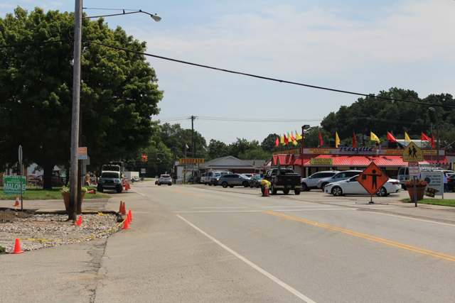
Photo: FunksBrother, CC BY-SA 4.0 · Wikimedia Commons
Local history sources: en.wikipedia.org · commons.wikimedia.org · en.wikipedia.org · archive.org · archive.org
Water
Ohio River surface water, treated at the Ironton Water Treatment Plant (built 1993, approved capacity 4 million gallons per day, about 1.3 MGD produced). The foot-of-Vernon-Street siting describes the original 1872 waterworks, not the current intake location. The water here
- Ironton64% of residentsOhio River
- Hecla Water Association21% of residentsOhio River
- Coal Grove15% of residentsGroundwater wells (3 wells)
- Scioto Water Inc.-sugar Camp1% of residentsGroundwater wells (6 wells)
Hospitals, fire stations and more
Inside Coal Grove's boundary: 2 health centers, 1 nursing home, 1 fire or EMS station, 2 public schools, 1 police station and 3 spill cases. Press a pin or a name for its whole record and its source.
Community health centers (2)
-
Coal Grove ClinicHealth center · Coal Grove
- Run by
- a federally qualified health center
- Setting
- Clinic
- City
- Coal Grove
- Coordinates
- 38.50357, -82.64825
Find a Health Center (HRSA) ↗ HRSA data (source) ↗ Street map and directions ↗
-
VALLEY HEALTH - COAL GROVEHealth center · Ironton
- Run by
- a federally qualified health center
- Setting
- Clinic
- City
- Ironton
- Coordinates
- 38.50151, -82.65227
Find a Health Center (HRSA) ↗ HRSA data (source) ↗ Street map and directions ↗
Source: HRSA health center service delivery sites, active, September 2026 (school-based sites left out). Health centers see patients whether or not they have insurance, with fees on a sliding scale.
Nursing homes (1)
-
Crystal Care of Coal Grove3 of 5 stars · Coal Grove
- Address
- 813 1/2 Marion Pike, Coal Grove, OH 45638
- Certified beds
- 57
- Residents on an average day
- 51
- Medicare overall rating
- 3 of 5 stars
- Health inspections
- 3 of 5 stars
- Staffing
- 1 of 5 stars
- Quality measures
- 5 of 5 stars
- Penalties since 2023
- 1 fine totalling $159,708, 1 payment denial (latest 2024-03-04)
- Ownership
- For profit - Corporation
- Chain
- HILLSTONE HEALTHCARE
- Takes
- Medicare and Medicaid
- Phone
- (740) 532-0449
- Medicare ID
- 366202
Medicare Care Compare ↗ CMS nursing home data (source) ↗ Street map and directions ↗
Source: CMS Care Compare nursing home provider and penalties files; Medicare star ratings run 1 to 5.
Fire and EMS stations (1)
-
Coal Grove Fire DepartmentCoal Grove
- Address
- 513 Carlton Davidson Lane, Coal Grove, OH 45638
- Coordinates
- 38.50288, -82.64857
USGS National Map structures (source) ↗ Street map and directions ↗
Source: USGS National Map structures (most Ohio records last updated 2019 to 2022), checked against the Columbus and Cleveland station lists. The department that answers a call is set by jurisdiction and mutual aid, not by distance.
Public schools (2)
-
Dawson-Bryant High School3 of 5 stars · Coal Grove
- Address
- 1 Hornet Ln, Coal Grove, OH 45638
- School district
- Dawson-Bryant Local School District
- Kind (NCES)
- Regular School
- Students, 2023-24
- 306
- Teachers (full-time equivalent)
- 18
- Report card, 2025-26
- 3 of 5 stars
- Performance index
- 69%
- Four-year graduation rate
- 98.7%
- Ohio building IRN
- 008219
- NCES school ID
- 390479203040
NCES school record ↗ Ohio School Report Card ↗ Street map and directions ↗
-
Dawson-Bryant Middle School2.5 of 5 stars · Coal Grove
- Address
- 1 Hornet Ln, Coal Grove, OH 45638
- School district
- Dawson-Bryant Local School District
- Kind (NCES)
- Regular School
- Students, 2023-24
- 257
- Teachers (full-time equivalent)
- 13
- Report card, 2025-26
- 2.5 of 5 stars
- Performance index
- 77.4%
- Ohio building IRN
- 008227
- NCES school ID
- 390479203041
NCES school record ↗ Ohio School Report Card ↗ Street map and directions ↗
Source: NCES EDGE public school locations 2024-25 and Common Core of Data 2023-24 (type, students, teachers); Ohio School Report Cards 2025-26 (Department of Education and Workforce), matched by name within the district.
Police stations (1)
-
Coal Grove Police DepartmentCoal Grove
- Address
- 513 Carlton Davidson Lane, Coal Grove, OH 45638
- Coordinates
- 38.50658, -82.64847
Where this record comes from ↗ USGS National Map structures (source) ↗ Street map and directions ↗
Source: USGS National Map structures, police stations, corrected and completed by hand (September 2026). The department that answers a call is set by jurisdiction, not by distance.
Spills reported since 2021 (3)
-
Other / All Other / Trade Name / Mixture / Solution Etc2025-05-05 · Coal Grove
- Reported
- 2025-05-05
- What spilled
- Other / All Other / Trade Name / Mixture / Solution Etc
- Where
- Coal Grove, Lawrence County
- Ohio EPA district office
- SEDO
- Ohio EPA case number
- 2505EPA0000704
Ohio EPA spill reports (source) ↗ Street map and directions ↗
-
Fuel Diesel / Diesel Fuel (Vehicle On Or Off Road)2022-07-13 · Coal Grove
- Reported
- 2022-07-13
- What spilled
- Fuel Diesel / Diesel Fuel (Vehicle On Or Off Road)
- Where
- Coal Grove, Lawrence County
- Ohio EPA district office
- SEDO
- Ohio EPA case number
- 2207EPA0001061
Ohio EPA spill reports (source) ↗ Street map and directions ↗
-
Oil Crude Reached water2021-02-13 · Coal Grove
- Reported
- 2021-02-13
- What spilled
- Oil Crude
- Largest amount reported
- 5,000 gallons
- Reached a waterway
- 44 - Ohio River
- Where
- Coal Grove, Lawrence County
- Ohio EPA district office
- SEDO
- Ohio EPA case number
- 2102EPA0000200
Ohio EPA spill reports (source) ↗ Street map and directions ↗
Source: Ohio EPA emergency response spill reports, 2021 to September 2026, one point per case where Ohio EPA placed it. A report is what the caller or responder recorded; amounts are often blank or estimated.
Its ZIP codes
Each ZIP code that touches Coal Grove, with the share of its residents who live here and the same headline figures as the ZIP page.
Local government
Who holds office in Coal Grove, how its elections and ballot issues came out, and the state auditor's record.
Elections for office
| Date | Office | Candidates and votes |
|---|---|---|
| 2021-11-02 | Member of Council | David Bush 38, 3.17%; Andy Holmes 203, 16.92%; Gregory Massie 192, 16.0%; Kimberly McKnight 312, 26.0%; Bill Moore 93, 7.75%; Frederick Phillip Roush 229, 19.08%; Jay Sherman 133, 11.08% |
| 2019-11-05 | Member of Council | Brandon Bazell 279, 22.02%; Robin Heaberlin 327, 25.81%; Gregory Massie 293, 23.13%; Denise Paulus 368, 29.04% |
| 2019-11-05 | Mayor | Andy Holmes 318, 43.92%; Gary Sherman 406, 56.08% |
Winners in bold. Results from the county board of elections' official canvass unless marked.
Auditor of State record
- No fiscal caution, watch or emergency on the Auditor of State's lists.
- Financial Audit, 2023 to 2024, released 2026-03-05
The county
Lawrence County: 9 ZIP codes, 20 cities, villages and townships, 58,180 people.
Nearby places
Rain and snow
How much has actually fallen on Coal Grove, day by day, from 1887 to now. Daily totals, not averages.
- rain, last 30 days
- 2.88 in
- 2026-09-30 to 2026-10-29
- rain so far in 2026
- 37.3 in
- 2.4 in below normal for the date
- snow so far in 2026
- 10.6 in
- a normal year brings 11.8 in
- a normal year
- 46.9 in
- average of 30 years, 1991-2020
| Month | Rain (in) | Snow (in) | Days counted |
|---|---|---|---|
| October 2026 | 2.88 | — | 29 |
| September 2026 | 4.17 | — | 30 |
| August 2026 | 4.36 | — | 31 |
| July 2026 | 5.81 | — | 31 |
| June 2026 | 2.75 | — | 30 |
| May 2026 | 6.73 | — | 31 |
| April 2026 | 3.25 | — | 30 |
| March 2026 | 3.42 | 3.5 | 31 |
| February 2026 | 1.51 | 4.9 | 28 |
| January 2026 | 2.41 | 2.2 | 31 |
| December 2025 | 2.23 | 6.9 | 31 |
| November 2025 | 4.14 | 0.5 | 30 |
| Wettest year | 2011 — 62.6 in |
|---|---|
| Driest year | 1930 — 24.6 in |
| Snowiest year | 1978 — 43.4 in |
| Wettest day on record | 4 August 1933 — 3.73 in |
| Heaviest snowfall in a day | 27 February 1906 — 14.07 in |
| Deepest snow on the ground | 14 March 1993 — 21.51 in |
Estimated, not measured. No rain gauge has ever stood inside Coal Grove, so every figure here is worked out from the gauges around it - the nearest ones weighted most. Treat them as close estimates rather than readings.
50,402 days of records, 1887-07-01 to 2026-10-29. Source: NOAA NCEI GHCN-Daily, 3,240 gauges in and around Ohio. A day is "gauged" when a gauge standing inside the boundary reported it, and the value is the mean of those gauges. Otherwise it is interpolated by inverse distance from every gauge reporting within 50 miles. Nothing is carried forward, back-filled or smoothed. Against NOAA nClimDiv county monthly precipitation over 136,848 complete county-months (checked 2026-10-31): correlation 0.9515, median absolute difference 0.217 in a month. Built 2026-10-31 from the Cracked Buckeye precipitation archive. Snow is the softer number — snowfall is measured by hand with a ruler, no agency publishes a gridded county snowfall series, and blowing snow defeats every observer.
Environmental permits and filings
What Ohio EPA has on file for Coal Grove: permits, inspections, violations, cleanups and the state loans behind sewer and water work. Every line links to the agency's own document.
- facilities and sites on file
- 30
- those placed on the map inside Coal Grove
| Program | Facilities and sites |
|---|---|
| State water loans | 7 |
| Contaminated-site cleanup | 5 |
| Site assessment | 4 |
| Wastewater and stormwater discharge | 4 |
| Hazardous waste | 3 |
| Landfills | 2 |
| Air pollution | 1 |
| Construction-debris landfills | 1 |
| Public drinking water | 1 |
| Source-water protection | 1 |
| Voluntary cleanup | 1 |
| Date | Facility or site | What |
|---|---|---|
| COAL GROVE PWS | Public drinking water compliance letter | |
| HILL TOP C&DD AND RECYCLING FACILITY | Construction-debris landfills permit | |
| HILL TOP C&DD AND RECYCLING FACILITY | Construction-debris landfills permit | |
| HILL TOP C&DD AND RECYCLING FACILITY | Construction-debris landfills inspection | |
| HILL TOP C&DD AND RECYCLING FACILITY | Construction-debris landfills permit | |
| HILL TOP C&DD AND RECYCLING FACILITY | Construction-debris landfills director's orders ended | |
| HILL TOP C&DD AND RECYCLING FACILITY | Construction-debris landfills permit | |
| HILL TOP C&DD AND RECYCLING FACILITY | Construction-debris landfills letter on director's orders | |
| HILL TOP C&DD AND RECYCLING FACILITY | Construction-debris landfills letter on director's orders | |
| HILL TOP C&DD AND RECYCLING FACILITY | Construction-debris landfills letter on director's orders | |
| HILL TOP C&DD AND RECYCLING FACILITY | Construction-debris landfills permit | |
| HILL TOP C&DD AND RECYCLING FACILITY | Construction-debris landfills permit | |
| HILL TOP C&DD AND RECYCLING FACILITY | Construction-debris landfills permit | |
| COAL GROVE PWS | Public drinking water report | |
| HILL TOP C&DD AND RECYCLING FACILITY | Landfills compliance letter | |
| HILL TOP C&DD AND RECYCLING FACILITY | Construction-debris landfills compliance letter | |
| HILL TOP C&DD AND RECYCLING FACILITY | Construction-debris landfills letter on director's orders | |
| HILL TOP C&DD AND RECYCLING FACILITY | Construction-debris landfills letter on director's orders | |
| HILL TOP C&DD AND RECYCLING FACILITY | Wastewater and stormwater discharge inspection | |
| HILL TOP C&DD AND RECYCLING FACILITY | Construction-debris landfills plan | |
| HILL TOP C&DD AND RECYCLING FACILITY | Construction-debris landfills letter on director's orders | |
| HILL TOP C&DD AND RECYCLING FACILITY | Construction-debris landfills inspection | |
| HILL TOP C&DD AND RECYCLING FACILITY | Construction-debris landfills inspection | |
| HILL TOP C&DD AND RECYCLING FACILITY | Construction-debris landfills letter on director's orders | |
| HILL TOP C&DD AND RECYCLING FACILITY | Construction-debris landfills plan |
Source: Ohio EPA eDocument portal (edocpub.epa.ohio.gov), indexed 2026-10-14. Facilities are placed on the map from Ohio EPA's own map layers, EPA's Facility Registry, coordinates written in the filings, or a geocoded street address. A permit filed under a private person's name (most are household septic systems) is counted but never named, placed or linked; licenses for individual workers and open-burning notices are left out entirely.
Quick answers
What county is Coal Grove, Ohio in?
Coal Grove is a village in Lawrence County, Ohio, with 1,889 residents.
How did Coal Grove, Ohio get its name?
Originally known as Petersburg (also spelled Petersburgh), a river hamlet still carrying that name when an Ironton-Petersburg horse streetcar line opened on July 4, 1888. Source
What ZIP code is Coal Grove, Ohio?
Most of Coal Grove is in ZIP code 45638.
Where does Coal Grove, Ohio get its water?
The main water source for Coal Grove (Ironton): Ohio River surface water, treated at the Ironton Water Treatment Plant (built 1993, approved capacity 4 million gallons per day, about 1.3 MGD produced). The foot-of-Vernon-Street siting describes the original 1872 waterworks, not the current intake location.
Cite this page
Cite this page as:
Cracked Buckeye, "Coal Grove, Lawrence County", https://crackedbuckeye.com/place/coal-grove/, built 2026-10-31, accessed [date].
How to cite · Report a correction · Built 2026-10-31
