South Bloomfield
Village · Pickaway County · 2,151 residents · 1% municipal income tax
Local events in South Bloomfield
11 events in the next 90 days from 1 public calendar. All local events in South Bloomfield
Checked October 20; the events page is refreshed daily.
How South Bloomfield began
South Bloomfield's own founding story is disputed even in its own records: the village's official history says the town was 'originally laid out in 1803,' with Gen. James Denny hired to survey 40 acres into 80 lots, while the 1906 county history instead credits David Denny as the founder in 1805, with James Denny, later of Circleville, as his hired surveyor; squatters, by the village's own account, were already in the area by 1798 or 1799, and the oldest known grave nearby is dated 1801. The founders hoped their plat, in what is now Harrison Township, would become the Pickaway County seat, but 'time and politics' worked against it. From 1819 the village spent about 27 years as a stop on the stagecoach line between Chillicothe, Circleville and Columbus, a line said to have carried some 1.2 million passengers, before being bypassed first by the Ohio Canal, built through nearby Millport instead, and then by the railroad, which ran through Ashville on its way to Circleville. South Bloomfield settled into quiet decline for a century before US 23 became a four-lane federal highway and, since 2000, has become one of the fastest-growing villages in central Ohio.
Settled as early as 1798-1799, per squatters described in the village's own history; the oldest known grave in the area, that of Sarah Holmes, is dated 1801, platted sources disagree: 1803 per the village's own history, 1805 per the 1906 Pickaway County history, by the village's own history credits the survey to Gen. James Denny alone; the 1906 county history says David Denny laid out the town and hired James Denny, later of Circleville, to survey it.
Where the name comes from
No source consulted explains why the village was named Bloomfield, or South Bloomfield specifically; Ohio has several places using the Bloomfield name (there is, for instance, a separate Bloomfield in Logan County), and none of the sources consulted compare South Bloomfield's naming to any of them.
Before the town
No source consulted names a Native American village, trail, mound, or treaty event specifically at South Bloomfield or elsewhere in Harrison Township. The village lies in the northern part of Pickaway County, north of the Pickaway Plains that were the documented core of Shawnee settlement in the 1770s (covered in the Pickaway Township file); nothing in the village's own history or the county histories consulted places any Native site this far north in the county. No county-level file yet exists for Pickaway County to point to for the wider Native history of the area.
Timeline
- — Squatters begin claiming land in the area that becomes South Bloomfield, according to the village's own history.
- — Sarah Holmes, daughter of Jonathan and Rachel Holmes, is buried in what becomes the Harrison Township cemetery; hers is the oldest dated gravestone found in the area, evidence of settlement before the town's own founding date.
- — The town is platted, 40 acres divided into 80 lots, in hopes of becoming the county seat; sources disagree on both the year and who is properly credited as founder (see Founded).
- — A stagecoach line, later the Columbus and Portsmouth Turnpike Road Company and eventually US Route 23, begins service through South Bloomfield on Monday, August 23, running twice weekly between Chillicothe, Circleville and Columbus.
- — Dr. J. C. Thompson, one of the earliest physicians of Harrison Township, locates at South Bloomfield and practices there for over 50 years.
- — After roughly 27 years and an estimated 1.2 million passengers, the stagecoach era ends as the Ohio Canal and then the railroad draw traffic away from South Bloomfield to nearby Millport, Ashville and Circleville.
- — The village's population stands at 250, having grown little since its founding.
- — The population reaches 424, a 69.6 percent increase.
- — The census records 2,143 residents, and by a 2025 estimate the population has grown further to 4,164, making South Bloomfield one of the fastest-growing villages in central Ohio.
Stories
A Town Twice Founded, on Paper
South Bloomfield cannot quite settle on its own origin story. A sign at the village's municipal building gives 1804 as the founding year, which the village's own official history calls 'a bit misleading.' That same history says the town was surveyed in 1803 by Gen. James Denny, later a prominent citizen of Circleville, working alone. The 1906 Pickaway County history tells it differently: David Denny laid out the town in 1805 and hired James Denny to do the surveying for him. Neither account can be confirmed against the other, and the oldest dated grave in the area, that of a child named Sarah Holmes, is from 1801, two to four years before either proposed founding date, a reminder that squatters had already been living on the ground before anyone thought to plat a town on it.
Twenty-Seven Years of Stagecoaches
For most of its first half-century, South Bloomfield's fortunes rode on a stagecoach line. Beginning Monday, August 23, 1819, coaches of the Columbus and Portsmouth Turnpike Road Company ran twice a week between Chillicothe, Circleville and Columbus, stopping in the village to change horses, feed and house passengers, and make repairs at one of as many as three blacksmith shops in town at once. The Scioto Gazette's notice for the line specified a four-horse coach and a two-horse coach, fares of seven cents a mile in the larger and five in the smaller, a ten-pound baggage allowance per passenger, and a strict rule that mailbags always ride inside, out of the rain. Over roughly 27 years the line is estimated to have carried 1.2 million passengers, before the Ohio Canal, built a mile east through the rival village of Millport, and then the railroad, which passed through Ashville instead, quietly ended the stagecoach era and, with it, South Bloomfield's hope of becoming the county seat.
Photographs
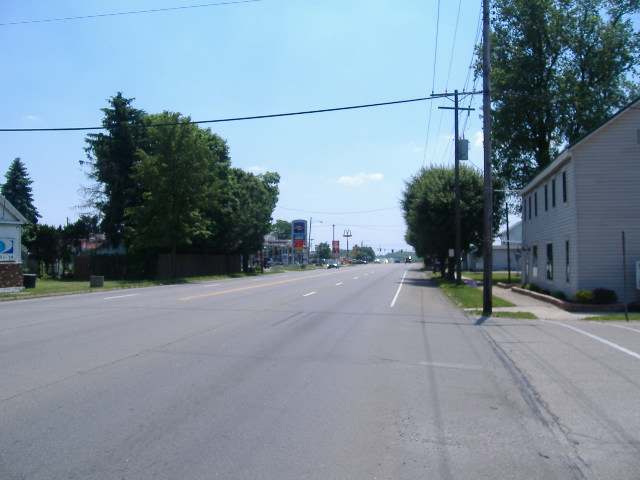
Photo: Aesopposea, via Wikimedia Commons, CC BY-SA 3.0 · Wikimedia Commons
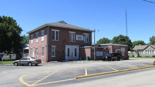
Photo: Aesopposea, via Wikimedia Commons, CC BY-SA 3.0 · Wikimedia Commons
Local history sources: web.archive.org · en.wikipedia.org · archive.org · en.wikipedia.org · commons.wikimedia.org · commons.wikimedia.org
Water
Mostly private wells The water here
- Ashville Village70% of residentsGroundwater wells (2 wells)
- South Bloomfield Village18% of residentsGroundwater wells (3 wells)
- Columbus Public Water System12% of residentsScioto River (Griggs & O'Shaughnessy), Hoover Reservoir on Big Walnut Ck, plus wells
- Commercial Point Village0% of residentsGroundwater wells (6 wells)
Hospitals, fire stations and more
Inside South Bloomfield's boundary: 1 public school, 1 police station and 1 spill case. Press a pin or a name for its whole record and its source.
Public schools (1)
-
South Bloomfield Elementary5 of 5 stars · South Bloomfield
- Address
- 194 Dowler Dr, South Bloomfield, OH 43103
- School district
- Teays Valley Local School District
- Kind (NCES)
- Regular School
- Students, 2023-24
- 546
- Teachers (full-time equivalent)
- 31.25
- Report card, 2025-26
- 5 of 5 stars
- Performance index
- 86.6%
- Ohio building IRN
- 011943
- NCES school ID
- 390490905628
NCES school record ↗ Ohio School Report Card ↗ Street map and directions ↗
Source: NCES EDGE public school locations 2024-25 and Common Core of Data 2023-24 (type, students, teachers); Ohio School Report Cards 2025-26 (Department of Education and Workforce), matched by name within the district.
Police stations (1)
-
South Bloomfield Police DepartmentSouth Bloomfield
- Address
- 5000 Park Place, South Bloomfield, OH 43103
- Coordinates
- 39.72101, -82.99084
USGS National Map structures (source) ↗ Street map and directions ↗
Source: USGS National Map structures, police stations, corrected and completed by hand (September 2026). The department that answers a call is set by jurisdiction, not by distance.
Spills reported since 2021 (1)
-
Fuel Diesel / Diesel Fuel (Vehicle On Or Off Road)2024-07-07 · South Bloomfield
- Reported
- 2024-07-07
- What spilled
- Fuel Diesel / Diesel Fuel (Vehicle On Or Off Road)
- Where
- South Bloomfield, Pickaway County
- Ohio EPA district office
- CDO
- Ohio EPA case number
- 2407EPA0001137
Ohio EPA spill reports (source) ↗ Street map and directions ↗
Source: Ohio EPA emergency response spill reports, 2021 to September 2026, one point per case where Ohio EPA placed it. A report is what the caller or responder recorded; amounts are often blank or estimated.
Its ZIP codes
Each ZIP code that touches South Bloomfield, with the share of its residents who live here and the same headline figures as the ZIP page.
| ZIP | Share | Water | Radon | Home value | Schools | Flood |
|---|---|---|---|---|---|---|
| 43103 Ashville | 18% | Mostly private wells | 8.3 pCi/L average radon | Median year built 1995 | Teays Valley Local · 4 stars overall | 9.9% of residents in the 1% floodplain |
Local government
Who holds office in South Bloomfield, how its elections and ballot issues came out, and the state auditor's record.
Elections for office
| Date | Office | Candidates and votes |
|---|---|---|
| 2023-11-07 | Member of Council | Aaron Thomas 626, 100.0% |
| 2023-11-07 | Mayor | Tom Ramsay 639, 100.0% |
| 2021-11-02 | Member of Council | Debbie Jones 185, 49.6%; Tom Ramsay 188, 50.4% |
| 2017-11-07 | Member of Council | Cynthia Hufnagle 117, 29.55%; Deborah K Jones 141, 35.61%; Donna Schaffer 138, 34.85% |
Winners in bold. Results from the county board of elections' official canvass unless marked.
The county
Pickaway County: 8 ZIP codes, 22 cities, villages and townships, 56,176 people.
Nearby places
Rain and snow
How much has actually fallen on South Bloomfield, day by day, from 1893 to now. Daily totals, not averages.
- rain, last 30 days
- 0.76 in
- 2026-09-30 to 2026-10-29
- rain so far in 2026
- 45.7 in
- 9.8 in above normal for the date
- snow so far in 2026
- 20.4 in
- a normal year brings 16.2 in
- a normal year
- 42.1 in
- average of 30 years, 1991-2020
| Month | Rain (in) | Snow (in) | Days counted |
|---|---|---|---|
| October 2026 | 0.76 | — | 29 |
| September 2026 | 7.44 | — | 30 |
| August 2026 | 9.08 | — | 31 |
| July 2026 | 5.82 | — | 31 |
| June 2026 | 2.76 | — | 30 |
| May 2026 | 6.06 | — | 31 |
| April 2026 | 3.44 | — | 30 |
| March 2026 | 7.06 | 1.3 | 31 |
| February 2026 | 1.89 | 5.0 | 28 |
| January 2026 | 1.34 | 14.1 | 31 |
| December 2025 | 2.34 | 11.4 | 31 |
| November 2025 | 2.31 | 1.0 | 30 |
| Wettest year | 2011 — 58.1 in |
|---|---|
| Driest year | 1930 — 24.5 in |
| Snowiest year | 1962 — 41.8 in |
| Wettest day on record | 4 July 1935 — 5.00 in |
| Heaviest snowfall in a day | 17 February 1910 — 12.99 in |
| Deepest snow on the ground | 22 January 1918 — 17.99 in |
Estimated, not measured. No rain gauge has ever stood inside South Bloomfield, so every figure here is worked out from the gauges around it - the nearest ones weighted most. Treat them as close estimates rather than readings.
47,441 days of records, 1893-01-01 to 2026-10-29. Source: NOAA NCEI GHCN-Daily, 3,240 gauges in and around Ohio. A day is "gauged" when a gauge standing inside the boundary reported it, and the value is the mean of those gauges. Otherwise it is interpolated by inverse distance from every gauge reporting within 50 miles. Nothing is carried forward, back-filled or smoothed. Against NOAA nClimDiv county monthly precipitation over 136,848 complete county-months (checked 2026-10-31): correlation 0.9515, median absolute difference 0.217 in a month. Built 2026-10-31 from the Cracked Buckeye precipitation archive. Snow is the softer number — snowfall is measured by hand with a ruler, no agency publishes a gridded county snowfall series, and blowing snow defeats every observer.
Environmental permits and filings
What Ohio EPA has on file for South Bloomfield: permits, inspections, violations, cleanups and the state loans behind sewer and water work. Every line links to the agency's own document.
- facilities and sites on file
- 22
- those placed on the map inside South Bloomfield
| Program | Facilities and sites |
|---|---|
| Wastewater and stormwater discharge | 17 |
| Public drinking water | 2 |
| Wetland and stream fill | 2 |
| Sewer and water-line construction | 1 |
| Date | Facility or site | What |
|---|---|---|
| SOUTH BLOOMFIELD WWTP NO 2 | Wastewater and stormwater discharge report | |
| SOUTH BLOOMFIELD WWTP NO 2 | Wastewater and stormwater discharge report | |
| SOUTH BLOOMFIELD VILLAGE PWS | Public drinking water report | |
| SOUTH BLOOMFIELD VILLAGE PWS | Public drinking water notice of violation | |
| SOUTH BLOOMFIELD VILLAGE PWS | Public drinking water compliance letter | |
| SOUTH BLOOMFIELD WWTP NO 2 | Wastewater and stormwater discharge report | |
| SOUTH BLOOMFIELD WWTP NO 2 | Wastewater and stormwater discharge report | |
| SOUTH BLOOMFIELD VILLAGE PWS | Public drinking water plan | |
| HSP INVESTMENTS NORTHUP AVENUE | Wastewater and stormwater discharge permit | |
| COOK CREEK NATURE PRESERVE WWTW | Wastewater and stormwater discharge report | |
| SOUTH BLOOMFIELD WWTP NO 2 | Wastewater and stormwater discharge report | |
| SOUTH BLOOMFIELD VILLAGE PWS | Public drinking water compliance letter | |
| SOUTH BLOOMFIELD VILLAGE PWS | Public drinking water compliance letter | |
| CLEARWATER DRIVE EXTENSION | Wastewater and stormwater discharge inspection | |
| HSP INVESTMENTS NORTHUP AVENUE | Wastewater and stormwater discharge inspection | |
| SOUTH BLOOMFIELD WWTP NO 2 | Wastewater and stormwater discharge report | |
| SOUTH BLOOMFIELD VILLAGE PWS | Public drinking water plan | |
| SOUTH BLOOMFIELD VILLAGE PWS | Public drinking water plan | |
| SOUTH BLOOMFIELD VILLAGE PWS | Public drinking water inspection | |
| SOUTH BLOOMFIELD WWTP NO 2 | Wastewater and stormwater discharge report | |
| SOUTH BLOOMFIELD WWTP NO 2 | Wastewater and stormwater discharge report | |
| SYCAMORE POINT | Wastewater and stormwater discharge permit | |
| SOUTH BLOOMFIELD WWTP NO 2 | Wastewater and stormwater discharge report | |
| SOUTH BLOOMFIELD WWTP NO 2 | Wastewater and stormwater discharge report | |
| SOUTH BLOOMFIELD VILLAGE PWS | Public drinking water monitoring results |
Source: Ohio EPA eDocument portal (edocpub.epa.ohio.gov), indexed 2026-10-14. Facilities are placed on the map from Ohio EPA's own map layers, EPA's Facility Registry, coordinates written in the filings, or a geocoded street address. A permit filed under a private person's name (most are household septic systems) is counted but never named, placed or linked; licenses for individual workers and open-burning notices are left out entirely.
Quick answers
What county is South Bloomfield, Ohio in?
South Bloomfield is a village in Pickaway County, Ohio, with 2,151 residents.
When was South Bloomfield, Ohio founded?
South Bloomfield was settled as early as 1798-1799, per squatters described in the village's own history; the oldest known grave in the area, that of Sarah Holmes, is dated 1801; laid out sources disagree: 1803 per the village's own history, 1805 per the 1906 Pickaway County history. Founders on record: the village's own history credits the survey to Gen. James Denny alone; the 1906 county history says David Denny laid out the town and hired James Denny, later of Circleville, to survey it. Source
What ZIP code is South Bloomfield, Ohio?
Most of South Bloomfield is in ZIP code 43103.
Where does South Bloomfield, Ohio get its water?
The main water source for South Bloomfield (Ashville Village): Mostly private wells.
Cite this page
Cite this page as:
Cracked Buckeye, "South Bloomfield, Pickaway County", https://crackedbuckeye.com/place/south-bloomfield/, built 2026-10-31, accessed [date].
How to cite · Report a correction · Built 2026-10-31
