Local events in Perry Township, Ashland County
Nothing is posted for Perry Township itself yet; here is what is on within 10 miles. All local events in Perry Township, Ashland County
Know a calendar we should watch? Send the link
Checked October 20; the events page is refreshed daily.
How Perry Township, Ashland County began
Perry Township, in the eastern part of Ashland County, was surveyed in 1807 by Jonathan Cox and organized on September 14, 1814, under Wayne County; until 1819 it also governed the land that became Jackson Township. John Raver built a grist and saw mill on Raver's Run near the site of Rowsburg in 1817 or 1818, which the 1909 county history calls the first mill within the present county. The village of Rowsburg was laid out at the township's center by Michael D. Row on April 15, 1835, and Lafayette in its north part the same spring; an earlier attempt, John Raver's Elizabethtown of 1815 or 1816, never grew past a name and a lot sale. By 1863 the township had Presbyterian, Methodist, Lutheran, Evangelical and United Brethren congregations, and township men served, by one account we could not confirm, in Company O of the 42nd Ohio Infantry, raised by James A. Garfield.
Settled by 1814, incorporated 1814-09-14 (township organized), by commissioners of Wayne County.
Where the name comes from
Not stated in any source read, including the 1863, 1880 and 1909 county histories. The township was organized in September 1814, a year after Commodore Oliver Hazard Perry's victory on Lake Erie, the namesake of many Ohio Perry townships, but no source confirms the connection for this one.
Before the town
The 1880 county history records two mounds in the north part of Perry Township, on level ground near a brook about a mile from Ramsey's Fort in Jackson Township. The larger, about five feet high and twenty-five feet across, was dug away by William Hamilton for a cellar; four feet down he found a triangular wooden post and three human skeletons in sand, and a polished stone that a neighbor turned into a whetstone. The 1909 history says Indian wigwams of poles and black ash or elm bark were numerous when settlers came, with bark troughs set at old notched sugar trees, and that in the fall of 1822 a party of nine Indian men and three women camped in the township to hunt and trap. No source names the nation of those hunters.
- Hamilton mounds (mound) — north part of Perry Township, on level ground near a brook, about a mile from Ramsey's Fort, prehistoric (culture not identified) (archive.org)
- Hunting camp of 1822 (camp) — Perry Township (exact site not given), fall 1822 (archive.org)
Timeline
- — Perry Township is surveyed by Jonathan Cox.
- — The commissioners of Wayne County organize Perry Township on September 14; its jurisdiction covers the future Jackson Township until 1819.
- — John Raver offers lots in a proposed town called Elizabethtown on the Wooster road between the site of Rowsburg and the Muddy Fork (1815 or 1816); nothing is built and the plan is dropped.
- — John Jackson is commissioned the township's first justice of the peace on July 3.
- — John Raver builds a grist and saw mill on Raver's Run, a quarter mile north of the future Rowsburg; the 1909 history calls it the first mill within the present county, and the 1880 history dates it to about 1817.
- — The township's population is counted at 558.
- — The Muddy Fork Presbyterian church is organized about this year under the Presbytery of Richland; it is renamed Mount Hope about 1831.
- — A Methodist society of twelve or fifteen members forms and meets for more than thirty years at the house of John Hellman.
- — The Muddy Fork (Mount Hope) congregation builds its first house of worship, of logs.
- — Eighty-eight men vote at the October election.
- — William Hamilton and John Zimmerman lay out Lafayette in the north part of the township in the spring.
- — Michael D. Row lays out Rowsburg on April 15 on the Ashland-Wooster road; at the lot sale in May, Jacob Carr buys the first lot for thirty-four dollars.
- — Mount Hope's frame church of 1836 burns on the night of March 6; a new one goes up that summer.
- — The English Evangelical Lutheran church is organized in January and builds a 30-by-45-foot church for $1,200.
- — Ashland County is formed and Perry Township becomes part of it.
- — The Methodists build a 38-by-50-foot church at Rowsburg, seating more than four hundred.
- — The township's population is 1,911; Rowsburg's is 200.
- — James A. Garfield, later the 20th U.S. President, recruits township men into Company O of the 42nd Ohio Infantry for Civil War service (we could not confirm this from a second source).
Stories
A wagonload of ginseng
For years after settlement Perry Township farmers had almost no market for their crops except newcomers, who paid fifty cents a bushel for wheat and twenty-five for corn, while salt cost twelve to fifteen dollars a barrel. One of the few things that brought cash was ginseng, which grew wild in the forests and was gathered every spring; merchants paid twenty-five cents a pound. Michael Row Sr., father of the man who later laid out Rowsburg, decided the merchants were paying far less than the root was worth. He loaded a one-horse wagon with ginseng, drove it to Philadelphia and found the trip paid. In 1835 his son Michael D. Row, then unmarried and living with his father forty rods east of the site, laid out Rowsburg on land with no inhabitant on it; Jacob Carr bought the first lot that May for thirty-four dollars.
A future president's recruits
In the opening months of the Civil War, James A. Garfield — then a state senator and college president who would go on to command Union troops, serve in Congress, and be elected the 20th President of the United States in 1880 — helped raise the 42nd Ohio Volunteer Infantry. Men from Perry Township answered the call and were mustered into Company O of that regiment, a direct link between one of Ashland County's smallest townships and a man who would occupy the White House two decades later. We could not confirm this from a second source.
Photographs
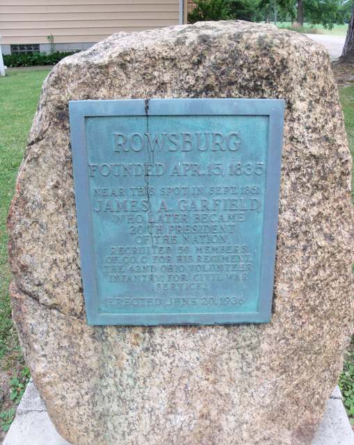
Photo: Roseohioresident, CC BY-SA 4.0 · Wikimedia Commons
Local history sources: en.wikipedia.org · en.wikipedia.org · archive.org · archive.org · archive.org · archive.org · archive.org · archive.org · archive.org · archive.org · archive.org · archive.org · commons.wikimedia.org
Water
Mostly private wells The water here
- Rural Lorain Co. Water A41% of residentsMostly Lake Erie (bought from Avon Lake); some New London Reservoir and Ashland wells
- Ashland City31% of residentsJerome Fork Basin sand-and-gravel aquifer (wells)
- Jeromesville Village22% of residentsGroundwater wells (2 wells)
- West Salem Village5% of residentsGroundwater wells (4 wells)
- Bailey Lakes Village1% of residentsLake Erie
- Hayesville Village0% of residentsGroundwater wells (2 wells)
Hospitals, fire stations and more
Inside Perry Township, Ashland County's boundary: 1 private school, 1 poor-rated bridge, 71 shale and injection wells and 11 spill cases. Press a pin or a name for its whole record and its source.
Private schools (1)
-
County Curve SchoolPrivate, religious, independent · Wooster
- Address
- 1692 County Road 175, Wooster, OH 44691
- Kind
- religious, independent
- Students, 2023-24
- 11
- Teachers (full-time equivalent)
- 1
- Students per teacher
- 11
- Phone
- (330) 345-6771
- NCES private school ID
- A1302293
Source: NCES Private School Survey 2023-24.
Bridges rated poor (1)
-
Township Road 1550 over Muddy ForkPoor · built 1932
- Condition
- Poor: a deck, superstructure, substructure or culvert rated 4 or below on the 0 to 9 scale
- What it is
- Bridge
- Built
- 1932
- Length
- 31 ft
- Owner
- County
- Vehicles a day
- 97
- Coordinates
- 40.83639, -82.13764
National Bridge Inventory (source) ↗ Street map and directions ↗
Source: FHWA National Bridge Inventory 2025. "Poor" means one major part rated 4 or below on the 0 to 9 scale; it calls for repair, not closing, unless the state posts or closes the bridge.
Shale and injection wells (71)
-
Anderson Unit (H & F Oil Co) {Erp 13} W-1 (2) InjectionInjection well (Class II)
- What it is
- Injection well (Class II)
- Operator
- Deep Resources Llc
- County
- Ashland County
- API well number
- 34005219700000
- Coordinates
- 40.89793, -82.14466
ODNR oil and gas wells (source) ↗ Street map and directions ↗
-
Anderson Unit {Erp#13} W-3 InjectionInjection well (Class II)
- What it is
- Injection well (Class II)
- Operator
- Deep Resources Llc
- County
- Ashland County
- API well number
- 34005220400000
- Coordinates
- 40.89724, -82.14394
ODNR oil and gas wells (source) ↗ Street map and directions ↗
-
Anderson Unit {Erp#13} W-4 InjectionInjection well (Class II)
- What it is
- Injection well (Class II)
- Operator
- Deep Resources Llc
- County
- Ashland County
- API well number
- 34005224620000
- Coordinates
- 40.89686, -82.14307
ODNR oil and gas wells (source) ↗ Street map and directions ↗
-
Anderson Unit {Erp#13} W-6 InjectionInjection well (Class II)
- What it is
- Injection well (Class II)
- Operator
- Deep Resources Llc
- County
- Ashland County
- API well number
- 34005220270000
- Coordinates
- 40.89697, -82.14340
ODNR oil and gas wells (source) ↗ Street map and directions ↗
-
Anderson Unit {Erp#13} W-7 InjectionInjection well (Class II)
- What it is
- Injection well (Class II)
- Operator
- Deep Resources Llc
- County
- Ashland County
- API well number
- 34005220240000
- Coordinates
- 40.89643, -82.14539
ODNR oil and gas wells (source) ↗ Street map and directions ↗
-
Anderson Unit {Erp#13} W-8 InjectionInjection well (Class II)
- What it is
- Injection well (Class II)
- Operator
- Deep Resources Llc
- County
- Ashland County
- API well number
- 34005220470000
- Coordinates
- 40.89642, -82.14394
ODNR oil and gas wells (source) ↗ Street map and directions ↗
-
Anderson {Erp#13} W-5 InjectionInjection well (Class II)
- What it is
- Injection well (Class II)
- Operator
- Deep Resources Llc
- County
- Ashland County
- API well number
- 34005220070000
- Coordinates
- 40.89605, -82.14487
ODNR oil and gas wells (source) ↗ Street map and directions ↗
-
Brettin George & Josephine {Erp 17} W-1 InjectionInjection well (Class II)
- What it is
- Injection well (Class II)
- Operator
- Deep Resources Llc
- County
- Ashland County
- API well number
- 34005208820000
- Coordinates
- 40.88606, -82.16642
ODNR oil and gas wells (source) ↗ Street map and directions ↗
-
Brettin George & Josephine {Erp 17} W-2 InjectionInjection well (Class II)
- What it is
- Injection well (Class II)
- Operator
- Deep Resources Llc
- County
- Ashland County
- API well number
- 34005205660000
- Coordinates
- 40.88578, -82.16588
ODNR oil and gas wells (source) ↗ Street map and directions ↗
-
Brettin George & Josephine {Erp 17} W-4 InjectionInjection well (Class II)
- What it is
- Injection well (Class II)
- Operator
- Deep Resources Llc
- County
- Ashland County
- API well number
- 34005207370000
- Coordinates
- 40.88454, -82.16733
ODNR oil and gas wells (source) ↗ Street map and directions ↗
-
Brettin George & Josephine {Erp 17} W-9 InjectionInjection well (Class II)
- What it is
- Injection well (Class II)
- Operator
- Deep Resources Llc
- County
- Ashland County
- API well number
- 34005216510000
- Coordinates
- 40.88277, -82.16771
ODNR oil and gas wells (source) ↗ Street map and directions ↗
-
Brettin {Erp#17} W-10 InjectionInjection well (Class II)
- What it is
- Injection well (Class II)
- Operator
- Deep Resources Llc
- County
- Ashland County
- API well number
- 34005237490000
- Coordinates
- 40.88277, -82.16734
ODNR oil and gas wells (source) ↗ Street map and directions ↗
-
Brettin {Erp#17} W-3 InjectionInjection well (Class II)
- What it is
- Injection well (Class II)
- Operator
- Deep Resources Llc
- County
- Ashland County
- API well number
- 34005237460000
- Coordinates
- 40.88455, -82.16770
ODNR oil and gas wells (source) ↗ Street map and directions ↗
-
Brettin {Erp#17} W-5 InjectionInjection well (Class II)
- What it is
- Injection well (Class II)
- Operator
- Deep Resources Llc
- County
- Ashland County
- API well number
- 34005237470000
- Coordinates
- 40.88455, -82.16697
ODNR oil and gas wells (source) ↗ Street map and directions ↗
-
Brettin {Erp#17} W-8 InjectionInjection well (Class II)
- What it is
- Injection well (Class II)
- Operator
- Deep Resources Llc
- County
- Ashland County
- API well number
- 34005237480000
- Coordinates
- 40.88305, -82.16843
ODNR oil and gas wells (source) ↗ Street map and directions ↗
-
Clark & Thelma Austin {Erp#12} W-23 InjectionInjection well (Class II)
- What it is
- Injection well (Class II)
- Operator
- Deep Resources Llc
- County
- Ashland County
- API well number
- 34005230590000
- Coordinates
- 40.89710, -82.15286
ODNR oil and gas wells (source) ↗ Street map and directions ↗
-
Ellen Smalley {Erp#16} W-2 InjectionInjection well (Class II)
- What it is
- Injection well (Class II)
- Operator
- Deep Resources Llc
- County
- Ashland County
- API well number
- 34005236010000
- Coordinates
- 40.88932, -82.15736
ODNR oil and gas wells (source) ↗ Street map and directions ↗
-
Ellen Smalley {Erp#16} W-6 InjectionInjection well (Class II)
- What it is
- Injection well (Class II)
- Operator
- Deep Resources Llc
- County
- Ashland County
- API well number
- 34005226240000
- Coordinates
- 40.88819, -82.15805
ODNR oil and gas wells (source) ↗ Street map and directions ↗
-
Ellen Smalley {Erp#16} W-8 InjectionInjection well (Class II)
- What it is
- Injection well (Class II)
- Operator
- Deep Resources Llc
- County
- Ashland County
- API well number
- 34005236050000
- Coordinates
- 40.88695, -82.15994
ODNR oil and gas wells (source) ↗ Street map and directions ↗
-
Ellen Smally {Erp#16} W-7 InjectionInjection well (Class II)
- What it is
- Injection well (Class II)
- Operator
- Deep Resources Llc
- County
- Ashland County
- API well number
- 34005228670000
- Coordinates
- 40.88728, -82.16040
ODNR oil and gas wells (source) ↗ Street map and directions ↗
-
Gilbert L & S (Erp 20) 7 InjectionInjection well (Class II)
- What it is
- Injection well (Class II)
- Operator
- Fawn Resources Llc
- County
- Ashland County
- API well number
- 34005241480000
- Coordinates
- 40.83386, -82.13380
ODNR oil and gas wells (source) ↗ Street map and directions ↗
-
Gilbert L & S (Erp 20) Injector 10 InjectionInjection well (Class II)
- What it is
- Injection well (Class II)
- Operator
- Fawn Resources Llc
- County
- Ashland County
- API well number
- 34005241550000
- Coordinates
- 40.83422, -82.13481
ODNR oil and gas wells (source) ↗ Street map and directions ↗
-
Gilbert L & S (Erp 20) Injector 11 InjectionInjection well (Class II)
- What it is
- Injection well (Class II)
- Operator
- Fawn Resources Llc
- County
- Ashland County
- API well number
- 34005241560000
- Coordinates
- 40.83442, -82.13560
ODNR oil and gas wells (source) ↗ Street map and directions ↗
-
Gilbert L & S (Erp 20) Injector 2G InjectionInjection well (Class II)
- What it is
- Injection well (Class II)
- Operator
- Fawn Resources Llc
- County
- Ashland County
- API well number
- 34005241190000
- Coordinates
- 40.83463, -82.13282
ODNR oil and gas wells (source) ↗ Street map and directions ↗
-
Gilbert L & S (Erp 20) Injector 8 InjectionInjection well (Class II)
- What it is
- Injection well (Class II)
- Operator
- Fawn Resources Llc
- County
- Ashland County
- API well number
- 34005241530000
- Coordinates
- 40.83358, -82.13188
ODNR oil and gas wells (source) ↗ Street map and directions ↗
-
Gilbert L & S (Erp 20) Injector 9 InjectionInjection well (Class II)
- What it is
- Injection well (Class II)
- Operator
- Fawn Resources Llc
- County
- Ashland County
- API well number
- 34005241540000
- Coordinates
- 40.83441, -82.13289
ODNR oil and gas wells (source) ↗ Street map and directions ↗
-
Gladys C. Mann {Erp#12} W-12 InjectionInjection well (Class II)
- What it is
- Injection well (Class II)
- Operator
- Deep Resources Llc
- County
- Ashland County
- API well number
- 34005230660000
- Coordinates
- 40.89445, -82.15578
ODNR oil and gas wells (source) ↗ Street map and directions ↗
-
Gladys C. Mann {Erp#12} W-14 InjectionInjection well (Class II)
- What it is
- Injection well (Class II)
- Operator
- Deep Resources Llc
- County
- Ashland County
- API well number
- 34005230680000
- Coordinates
- 40.89468, -82.15154
ODNR oil and gas wells (source) ↗ Street map and directions ↗
-
Gladys Mann {Erp#12} W-13 InjectionInjection well (Class II)
- What it is
- Injection well (Class II)
- Operator
- Deep Resources Llc
- County
- Ashland County
- API well number
- 34005230670000
- Coordinates
- 40.88725, -82.16245
ODNR oil and gas wells (source) ↗ Street map and directions ↗
-
Gortner (Erp #12) W-11 InjectionInjection well (Class II)
- What it is
- Injection well (Class II)
- Operator
- Deep Resources Llc
- County
- Ashland County
- API well number
- 34005230750000
- Coordinates
- 40.90053, -82.15964
ODNR oil and gas wells (source) ↗ Street map and directions ↗
-
Gortner (Erp #12) W200 InjectionInjection well (Class II)
- What it is
- Injection well (Class II)
- Operator
- Deep Resources Llc
- County
- Ashland County
- API well number
- 34005241420000
- Coordinates
- 40.89153, -82.15304
ODNR oil and gas wells (source) ↗ Street map and directions ↗
-
Gortner R & P (Erp #12) W-19-A InjectionInjection well (Class II)
- What it is
- Injection well (Class II)
- Operator
- Deep Resources Llc
- County
- Ashland County
- API well number
- 34005231200000
- Coordinates
- 40.89587, -82.15113
ODNR oil and gas wells (source) ↗ Street map and directions ↗
-
Gortner Robert & Pauline (Erp #12) W-1 InjectionInjection well (Class II)
- What it is
- Injection well (Class II)
- Operator
- Deep Resources Llc
- County
- Ashland County
- API well number
- 34005230700000
- Coordinates
- 40.89776, -82.16442
ODNR oil and gas wells (source) ↗ Street map and directions ↗
-
Gortner Robert & Pauline (Erp #12) W-2 InjectionInjection well (Class II)
- What it is
- Injection well (Class II)
- Operator
- Deep Resources Llc
- County
- Ashland County
- API well number
- 34005230710000
- Coordinates
- 40.89771, -82.16295
ODNR oil and gas wells (source) ↗ Street map and directions ↗
-
Gortner {Erp#12} W-3 InjectionInjection well (Class II)
- What it is
- Injection well (Class II)
- Operator
- Deep Resources Llc
- County
- Ashland County
- API well number
- 34005226280000
- Coordinates
- 40.89026, -82.15159
ODNR oil and gas wells (source) ↗ Street map and directions ↗
-
Gortner {Erp#12} W-4 InjectionInjection well (Class II)
- What it is
- Injection well (Class II)
- Operator
- Deep Resources Llc
- County
- Ashland County
- API well number
- 34005230720000
- Coordinates
- 40.89922, -82.16460
ODNR oil and gas wells (source) ↗ Street map and directions ↗
-
Gortner {Erp#12} W-5 InjectionInjection well (Class II)
- What it is
- Injection well (Class II)
- Operator
- Deep Resources Llc
- County
- Ashland County
- API well number
- 34005222200000
- Coordinates
- 40.89178, -82.15336
ODNR oil and gas wells (source) ↗ Street map and directions ↗
-
Gortner(Erp #12) W201 InjectionInjection well (Class II)
- What it is
- Injection well (Class II)
- Operator
- Deep Resources Llc
- County
- Ashland County
- API well number
- 34005241430000
- Coordinates
- 40.89310, -82.15315
ODNR oil and gas wells (source) ↗ Street map and directions ↗
-
H & G Hastings {Erp#12} W-123 InjectionInjection well (Class II)
- What it is
- Injection well (Class II)
- Operator
- Deep Resources Llc
- County
- Ashland County
- API well number
- 34005238410000
- Coordinates
- 40.89684, -82.14702
ODNR oil and gas wells (source) ↗ Street map and directions ↗
-
H & G Hastings {Erp#12} W-124 InjectionInjection well (Class II)
- What it is
- Injection well (Class II)
- Operator
- Deep Resources Llc
- County
- Ashland County
- API well number
- 34005238770000
- Coordinates
- 40.89794, -82.14701
ODNR oil and gas wells (source) ↗ Street map and directions ↗
-
H & G Hastings {Erp#12} W-125 InjectionInjection well (Class II)
- What it is
- Injection well (Class II)
- Operator
- Deep Resources Llc
- County
- Ashland County
- API well number
- 34005238760000
- Coordinates
- 40.89548, -82.14919
ODNR oil and gas wells (source) ↗ Street map and directions ↗
-
H. & G. Hastings {Erp#12} W-37 InjectionInjection well (Class II)
- What it is
- Injection well (Class II)
- Operator
- Deep Resources Llc
- County
- Ashland County
- API well number
- 34005221320000
- Coordinates
- 40.89932, -82.15068
ODNR oil and gas wells (source) ↗ Street map and directions ↗
-
H. & G. Hastings {Erp#12} W-44 InjectionInjection well (Class II)
- What it is
- Injection well (Class II)
- Operator
- Deep Resources Llc
- County
- Ashland County
- API well number
- 34005223470000
- Coordinates
- 40.90044, -82.14757
ODNR oil and gas wells (source) ↗ Street map and directions ↗
-
Harold & Gladys Hastings {Erp#12} W-24 InjectionInjection well (Class II)
- What it is
- Injection well (Class II)
- Operator
- Deep Resources Llc
- County
- Ashland County
- API well number
- 34005230460000
- Coordinates
- 40.89724, -82.15124
ODNR oil and gas wells (source) ↗ Street map and directions ↗
-
Harold & Gladys Hastings {Erp#12} W-27 InjectionInjection well (Class II)
- What it is
- Injection well (Class II)
- Operator
- Deep Resources Llc
- County
- Ashland County
- API well number
- 34005230480000
- Coordinates
- 40.89693, -82.14590
ODNR oil and gas wells (source) ↗ Street map and directions ↗
-
Harold & Gladys Hastings {Erp#12} W-30 InjectionInjection well (Class II)
- What it is
- Injection well (Class II)
- Operator
- Deep Resources Llc
- County
- Ashland County
- API well number
- 34005230490000
- Coordinates
- 40.89807, -82.16093
ODNR oil and gas wells (source) ↗ Street map and directions ↗
-
Harold & Gladys Hastings {Erp#12} W-32 InjectionInjection well (Class II)
- What it is
- Injection well (Class II)
- Operator
- Deep Resources Llc
- County
- Ashland County
- API well number
- 34005230510000
- Coordinates
- 40.89801, -82.14745
ODNR oil and gas wells (source) ↗ Street map and directions ↗
-
Harold & Gladys Hastings {Erp#12} W-33 InjectionInjection well (Class II)
- What it is
- Injection well (Class II)
- Operator
- Deep Resources Llc
- County
- Ashland County
- API well number
- 34005230520000
- Coordinates
- 40.89797, -82.14590
ODNR oil and gas wells (source) ↗ Street map and directions ↗
-
Hastings Harold & Gladys {Erp 12} W-20 InjectionInjection well (Class II)
- What it is
- Injection well (Class II)
- Operator
- Deep Resources Llc
- County
- Ashland County
- API well number
- 34005218390000
- Coordinates
- 40.89581, -82.14994
ODNR oil and gas wells (source) ↗ Street map and directions ↗
-
Hastings Harold & Gladys {Erp 12} W-21 InjectionInjection well (Class II)
- What it is
- Injection well (Class II)
- Operator
- Deep Resources Llc
- County
- Ashland County
- API well number
- 34005218500000
- Coordinates
- 40.89527, -82.14849
ODNR oil and gas wells (source) ↗ Street map and directions ↗
-
Hastings {Erp#12} W-121 InjectionInjection well (Class II)
- What it is
- Injection well (Class II)
- Operator
- Deep Resources Llc
- County
- Ashland County
- API well number
- 34005238400000
- Coordinates
- 40.89547, -82.14720
ODNR oil and gas wells (source) ↗ Street map and directions ↗
-
Hastings {Erp#12} W-122 InjectionInjection well (Class II)
- What it is
- Injection well (Class II)
- Operator
- Deep Resources Llc
- County
- Ashland County
- API well number
- 34005238420000
- Coordinates
- 40.89685, -82.14901
ODNR oil and gas wells (source) ↗ Street map and directions ↗
-
Hastings {Erp#12} W-26 InjectionInjection well (Class II)
- What it is
- Injection well (Class II)
- Operator
- Deep Resources Llc
- County
- Ashland County
- API well number
- 34005220800000
- Coordinates
- 40.89751, -82.14732
ODNR oil and gas wells (source) ↗ Street map and directions ↗
-
Miller Thomas W Jr W-10-1 InjectionInjection well (Class II) · Well drilled
- What it is
- Injection well (Class II)
- Status (ODNR)
- Well drilled
- County
- Ashland County
- API well number
- 34005617710000
- Coordinates
- 40.89269, -82.15802
ODNR oil and gas wells (source) ↗ Street map and directions ↗
-
Miller Thomas W Jr W9 InjectionInjection well (Class II) · Well drilled
- What it is
- Injection well (Class II)
- Status (ODNR)
- Well drilled
- County
- Ashland County
- API well number
- 34005617700000
- Coordinates
- 40.89237, -82.16326
ODNR oil and gas wells (source) ↗ Street map and directions ↗
-
R & P Gortner {Erp#12} W-127 InjectionInjection well (Class II)
- What it is
- Injection well (Class II)
- Operator
- Deep Resources Llc
- County
- Ashland County
- API well number
- 34005239110000
- Coordinates
- 40.89438, -82.14974
ODNR oil and gas wells (source) ↗ Street map and directions ↗
-
R & P Gortner {Erp#12} W-129 InjectionInjection well (Class II)
- What it is
- Injection well (Class II)
- Operator
- Deep Resources Llc
- County
- Ashland County
- API well number
- 34005239120000
- Coordinates
- 40.89301, -82.15156
ODNR oil and gas wells (source) ↗ Street map and directions ↗
-
R. & P. Gortner {Erp #12} W-135 InjectionInjection well (Class II)
- What it is
- Injection well (Class II)
- Operator
- Deep Resources Llc
- County
- Ashland County
- API well number
- 34005239130000
- Coordinates
- 40.89465, -82.14793
ODNR oil and gas wells (source) ↗ Street map and directions ↗
-
R. D. Bland {Erp#16} W-5 InjectionInjection well (Class II)
- What it is
- Injection well (Class II)
- Operator
- Deep Resources Llc
- County
- Ashland County
- API well number
- 34005221350000
- Coordinates
- 40.88845, -82.15844
ODNR oil and gas wells (source) ↗ Street map and directions ↗
-
R. D. Bland {Erp#16} W-6 InjectionInjection well (Class II)
- What it is
- Injection well (Class II)
- Operator
- Deep Resources Llc
- County
- Ashland County
- API well number
- 34005221840000
- Coordinates
- 40.88820, -82.15805
ODNR oil and gas wells (source) ↗ Street map and directions ↗
-
Robert & Pauline Gortner {Erp#12} W-15 InjectionInjection well (Class II)
- What it is
- Injection well (Class II)
- Operator
- Deep Resources Llc
- County
- Ashland County
- API well number
- 34005231010000
- Coordinates
- 40.89473, -82.15083
ODNR oil and gas wells (source) ↗ Street map and directions ↗
-
Robert & Pauline Gortner {Erp#12} W-16 InjectionInjection well (Class II)
- What it is
- Injection well (Class II)
- Operator
- Deep Resources Llc
- County
- Ashland County
- API well number
- 34005230760000
- Coordinates
- 40.88739, -82.14871
ODNR oil and gas wells (source) ↗ Street map and directions ↗
-
Robert & Pauline Gortner {Erp#12} W-46 InjectionInjection well (Class II)
- What it is
- Injection well (Class II)
- Operator
- Deep Resources Llc
- County
- Ashland County
- API well number
- 34005231050000
- Coordinates
- 40.89458, -82.14725
ODNR oil and gas wells (source) ↗ Street map and directions ↗
-
Robert & Pauline Gortner {Erp#12} W-7 InjectionInjection well (Class II)
- What it is
- Injection well (Class II)
- Operator
- Deep Resources Llc
- County
- Ashland County
- API well number
- 34005230730000
- Coordinates
- 40.89244, -82.14966
ODNR oil and gas wells (source) ↗ Street map and directions ↗
-
Robt. & P. Gortner {Erp#12} W-10 InjectionInjection well (Class II)
- What it is
- Injection well (Class II)
- Operator
- Deep Resources Llc
- County
- Ashland County
- API well number
- 34005220000000
- Coordinates
- 40.89289, -82.15217
ODNR oil and gas wells (source) ↗ Street map and directions ↗
-
Robt. & P. Gortner {Erp#12} W-6 InjectionInjection well (Class II)
- What it is
- Injection well (Class II)
- Operator
- Deep Resources Llc
- County
- Ashland County
- API well number
- 34005222870000
- Coordinates
- 40.89151, -82.15180
ODNR oil and gas wells (source) ↗ Street map and directions ↗
-
Robt. & P. Gortner {Erp#12} W-9 InjectionInjection well (Class II)
- What it is
- Injection well (Class II)
- Operator
- Deep Resources Llc
- County
- Ashland County
- API well number
- 34005221170000
- Coordinates
- 40.89321, -82.15303
ODNR oil and gas wells (source) ↗ Street map and directions ↗
-
Smalley Ellen (Erp #16) W-1 InjectionInjection well (Class II)
- What it is
- Injection well (Class II)
- Operator
- Deep Resources Llc
- County
- Ashland County
- API well number
- 34005223440000
- Coordinates
- 40.88985, -82.15740
ODNR oil and gas wells (source) ↗ Street map and directions ↗
-
Smalley Ellen (Erp #16) W-4 InjectionInjection well (Class II)
- What it is
- Injection well (Class II)
- Operator
- Deep Resources Llc
- County
- Ashland County
- API well number
- 34005226230000
- Coordinates
- 40.88873, -82.15882
ODNR oil and gas wells (source) ↗ Street map and directions ↗
-
Smalley Ellen (Erp #16) W-5 InjectionInjection well (Class II)
- What it is
- Injection well (Class II)
- Operator
- Deep Resources Llc
- County
- Ashland County
- API well number
- 34005236000000
- Coordinates
- 40.88837, -82.15864
ODNR oil and gas wells (source) ↗ Street map and directions ↗
-
Smith Glenn H 66 InjectionInjection well (Class II) · Well drilled
- What it is
- Injection well (Class II)
- Status (ODNR)
- Well drilled
- County
- Ashland County
- API well number
- 34005225360000
- Coordinates
- 40.89658, -82.14625
ODNR oil and gas wells (source) ↗ Street map and directions ↗
Source: ODNR Division of Oil and Gas Resources well inventory (September 2026): drilled Utica, Marcellus and horizontal wells and Class II injection wells not plugged. Older vertical wells are on the full map.
Spills reported since 2021 (11)
-
Sulfuric Acid (H2S04)2025-06-20 · Perry Twp
- Reported
- 2025-06-20
- What spilled
- Sulfuric Acid (H2S04)
- Largest amount reported
- 3 gallons
- Where
- Perry Twp, Ashland County
- Ohio EPA district office
- NWDO
- Ohio EPA case number
- 2506EPA0001024
Ohio EPA spill reports (source) ↗ Street map and directions ↗
-
Fuel Diesel / Diesel Fuel (Vehicle On Or Off Road)2024-07-21 · Perry Twp
- Reported
- 2024-07-21
- What spilled
- Fuel Diesel / Diesel Fuel (Vehicle On Or Off Road)
- Largest amount reported
- 70 gallons
- Where
- Perry Twp, Ashland County
- Ohio EPA district office
- NWDO
- Ohio EPA case number
- 2407EPA0001241
Ohio EPA spill reports (source) ↗ Street map and directions ↗
-
Milk2024-06-04 · Perry Twp
- Reported
- 2024-06-04
- What spilled
- Milk
- Largest amount reported
- 300 gallons
- Where
- Perry Twp, Ashland County
- Ohio EPA district office
- NWDO
- Ohio EPA case number
- 2406EPA0000936
Ohio EPA spill reports (source) ↗ Street map and directions ↗
-
Fuel Diesel / Diesel Fuel (Vehicle On Or Off Road)2023-05-05 · Perry Twp
- Reported
- 2023-05-05
- What spilled
- Fuel Diesel / Diesel Fuel (Vehicle On Or Off Road)
- Largest amount reported
- 200 gallons
- Where
- Perry Twp, Ashland County
- Ohio EPA district office
- NWDO
- Ohio EPA case number
- 2305EPA0000729
Ohio EPA spill reports (source) ↗ Street map and directions ↗
-
Fuel Diesel / Diesel Fuel (Vehicle On Or Off Road)2022-10-06 · Perry Twp
- Reported
- 2022-10-06
- What spilled
- Fuel Diesel / Diesel Fuel (Vehicle On Or Off Road)
- Largest amount reported
- 50 gallons
- Where
- Perry Twp, Ashland County
- Ohio EPA district office
- NWDO
- Ohio EPA case number
- 2210EPA0001518
Ohio EPA spill reports (source) ↗ Street map and directions ↗
-
Fuel Diesel / Diesel Fuel (Vehicle On Or Off Road)2022-02-18 · Perry Twp
- Reported
- 2022-02-18
- What spilled
- Fuel Diesel / Diesel Fuel (Vehicle On Or Off Road)
- Largest amount reported
- 250 gallons
- Where
- Perry Twp, Ashland County
- Ohio EPA district office
- NWDO
- Ohio EPA case number
- 2202EPA0000200
Ohio EPA spill reports (source) ↗ Street map and directions ↗
-
Fuel Diesel / Diesel Fuel (Vehicle On Or Off Road)2022-02-03 · Perry Twp
- Reported
- 2022-02-03
- What spilled
- Fuel Diesel / Diesel Fuel (Vehicle On Or Off Road)
- Where
- Perry Twp, Ashland County
- Ohio EPA district office
- NWDO
- Ohio EPA case number
- 2202EPA0000125
Ohio EPA spill reports (source) ↗ Street map and directions ↗
-
Fuel Diesel / Diesel Fuel (Vehicle On Or Off Road)2021-12-02 · Perry Twp
- Reported
- 2021-12-02
- What spilled
- Fuel Diesel / Diesel Fuel (Vehicle On Or Off Road)
- Largest amount reported
- 100 gallons
- Where
- Perry Twp, Ashland County
- Ohio EPA district office
- NWDO
- Ohio EPA case number
- 2112EPA0001806
Ohio EPA spill reports (source) ↗ Street map and directions ↗
-
Oil Crude2021-06-30 · Perry Twp
- Reported
- 2021-06-30
- What spilled
- Oil Crude
- Where
- Perry Twp, Ashland County
- Ohio EPA district office
- NWDO
- Ohio EPA case number
- 2106EPA0000967
Ohio EPA spill reports (source) ↗ Street map and directions ↗
-
Brine Oil And Gas Related Reached water2021-06-25 · Perry Twp
- Reported
- 2021-06-25
- What spilled
- Brine Oil And Gas Related
- Largest amount reported
- 8 gallons
- Reached a waterway
- 03 - Scott Run
- Where
- Perry Twp, Ashland County
- Ohio EPA district office
- NWDO
- Ohio EPA case number
- 2106EPA0000927
Ohio EPA spill reports (source) ↗ Street map and directions ↗
-
Antifreeze Vehicle Cooling2021-06-11 · Perry Twp
- Reported
- 2021-06-11
- What spilled
- Antifreeze Vehicle Cooling
- Largest amount reported
- 140 gallons
- Where
- Perry Twp, Ashland County
- Ohio EPA district office
- NWDO
- Ohio EPA case number
- 2106EPA0000842
Ohio EPA spill reports (source) ↗ Street map and directions ↗
Source: Ohio EPA emergency response spill reports, 2021 to September 2026, one point per case where Ohio EPA placed it. A report is what the caller or responder recorded; amounts are often blank or estimated.
Its ZIP codes
Each ZIP code that touches Perry Township, Ashland County, with the share of its residents who live here and the same headline figures as the ZIP page.
| ZIP | Share | Water | Radon | Home value | Schools | Flood |
|---|---|---|---|---|---|---|
| 44866 Jackson Township and Polk | 33% | Mostly private wells | 4.9 pCi/L average radon | Median year built 1992 | Mapleton Local · 4 stars overall | 0.0% of residents in the 1% floodplain |
| 44840 Mohican Township and Jeromesville | 24% | Mostly private wells | 6.7 pCi/L average radon | Median year built 1981 | Hillsdale Local · 4 stars overall | 3.4% of residents in the 1% floodplain |
| 44287 Jackson Township and West Salem | 2% | Mostly private wells | 4.1 pCi/L average radon | Median year built 1986 | Northwestern Local · 4 stars overall | 1.0% of residents in the 1% floodplain |
| 44805 Ashland | 1% | Wells (14 listed as active in EPA SDWIS: Wells 1-7 and 10-15; Well 9 was deactivated 2025-11-17) in the Jerome Fork Basin sand-and-gravel aquifer, sited generally north of the treatment plant on Cleveland Road | 5.8 pCi/L average radon | Median year built 1964 | Ashland City · 4 stars overall | 2.6% of residents in the 1% floodplain |
Local government
Who holds office in Perry Township, Ashland County, how its elections and ballot issues came out, and the state auditor's record.
Money issues on the ballot since 2025: 1 of 1 passed.
Ballot issues
| Date | Issue | For | Against | Result |
|---|---|---|---|---|
| 2025-11-04 | Issue: Perry Township, Renewal Levy, Roads/Bridges, 2m/5yrs. (2.0 mills, renewal) | 174 | 98 | Passed (63.97% for), unofficial |
| 2022-11-08 | Issue: Perry TWP., Liquor - Muddy Fork Drive-Thru | 572 | 176 | Passed (76.47% for) |
| 2022-11-08 | Issue: Perry TWP., Liquor, Sunday Sales - Muddy Fork Drive-Thru | 520 | 234 | Passed (68.97% for) |
| 2020-11-03 | Issue: Perry Twp Ren RB 2m (2.0 mills) | 684 | 291 | Passed (70.15% for) |
Elections for office
| Date | Office | Candidates and votes |
|---|---|---|
| 2025-11-04 | Township Trustee (unofficial count) | Brian G. Funk 198, 59.46%; Burton Williams 135, 40.54% |
| 2023-11-07 | Township Trustee (unofficial count) | Kent McGovern 312, 47.93%; James E. Uhler 339, 52.07% |
| 2023-11-07 | Township Fiscal Officer (unofficial count) | Valerie K. Hall 561, 100.0% |
| 2021-11-02 | Township Trustee | Brian G. Funk 242, 59.31%; Burton Williams 166, 40.69% |
| 2019-11-05 | Township Trustee | Kent McGovern 243, 100.0% |
| 2019-11-05 | Township Fiscal Officer | Valerie K. Hall 236, 100.0% |
| 2017-11-07 | Township Trustee | Brian G. Funk 228, 36.95%; DeForest Kelley 144, 23.34%; Burton Williams 245, 39.71% |
Winners in bold. Results from the county board of elections' official canvass unless marked.
Auditor of State record
- No fiscal caution, watch or emergency on the Auditor of State's lists.
- Financial Audit, 2023 to 2024, released 2025-08-05
The county
Ashland County: 9 ZIP codes, 22 cities, villages and townships, 50,803 people.
Nearby places
Quick answers
What county is Perry Township, Ohio in?
Perry Township, Ashland County is a township in Ashland County, Ohio, with 2,024 residents.
When was Perry Township, Ohio founded?
Perry Township, Ashland County was settled by 1814; incorporated 1814-09-14 (township organized). Founders on record: commissioners of Wayne County. Source
How did Perry Township, Ohio get its name?
Not stated in any source read, including the 1863, 1880 and 1909 county histories. Source
What ZIP code is Perry Township, Ohio?
Perry Township, Ashland County is served by ZIP codes 44866 and 44840; 44866 holds the largest share of its residents.
Where does Perry Township, Ohio get its water?
The main water source for Perry Township, Ashland County (Rural Lorain Co. Water A): Mostly private wells.
Cite this page
Cite this page as:
Cracked Buckeye, "Perry Township, Ashland County", https://crackedbuckeye.com/place/perry-township-ashland-county/, built 2026-10-31, accessed [date].
How to cite · Report a correction · Built 2026-10-31
