Local events in Bailey Lakes
Nothing is posted for Bailey Lakes itself yet; here is what is on within 10 miles. All local events in Bailey Lakes
Know a calendar we should watch? Send the link
Checked October 20; the events page is refreshed daily.
How Bailey Lakes began
Bailey Lakes is a small lake village in Clear Creek Township, incorporated in May 1961 around a cluster of natural lakes (James Lake, Spring Lake, and Mud Lake, also called Savannah Lake) that form the headwaters of the Vermilion River. It grew out of a lake-cottage community rather than a platted farm town, which sets it apart from most Ashland County villages that trace to 1810s-1840s survey plats. It has always been small, peaking at around 400 residents in the late 20th century and standing at 349 in 2020.
Incorporated 1961.
Where the name comes from
The village takes its name from Bailey Lake, one of the small lakes it surrounds. No source read says who Bailey was. Bailey families were among Clear Creek Township's pioneers (see the timeline), but no source connects them to the lake. In the 19th century the two lakes southeast of Savannah were known locally as the McWilliams and McLain lakes.
Before the town
No source found names a Native village, camp, or trail specifically at the Bailey Lakes site. Three dugout canoes have been recovered from the lakes (1957, 1962, and the Ringler Dugout Canoe in 1976, the last preserved by the Cleveland Museum of Natural History), physical evidence of pre-contact or early historic use of the lakes, though the canoes' makers and period are not established in the sources found. Clear Creek Township's Sprott's Hill Mounds Site, a NRHP-listed prehistoric mound group, lies within the same township (along Township Road 1193 north of Ashland) but is not sited at Bailey Lakes itself. County-level Wyandot, Delaware (Lenape), and Shawnee presence is recorded for Ashland County generally. The 1880 county history adds that one of the historic-era trails of the county passed the Burns, Newell and Carter homesteads and ran 'to the Vermillion lake, and down the Vermillion river' toward the Huron. The National Register list places the Sprott's Hill mounds between Bailey Lake and Ashland.
- Sprott's Hill Mounds Site (mound) — western side of Township Road 1193 between Bailey Lake and Ashland, Clear Creek Township (not within Bailey Lakes village limits) (en.wikipedia.org)
Timeline
- — Clear Creek Township, which contains Bailey Lakes, is organized (October 15, 1818) out of the north half of Milton Township.
- — Nathaniel, Abel and John Bailey are among the pioneer heads of family in Clear Creek Township at its organization, according to the 1880 county history; no source links them to the name of Bailey Lake.
- — John Hendricks builds a water mill on Vermillion Creek about a mile west of Savannah; a later owner, Joseph Roop, digs a deep ditch from the lower lake to raise the flow and only drains that lake, and the mill fails.
- — The county history describes two spring-fed lakes a short distance southeast of Savannah, in a basin of the dividing ridge: the upper and larger of about 160 acres, and the partly drained lower one of about 80 acres, used for canoe fishing and picnics; the Vermillion River rises in them.
- — The 1909 county history calls these the Vermillion lakes, known locally as the McWilliams lake (the larger and deeper) and the McLain lake, with a grove beside each and campers in summer.
- — A dugout canoe is recovered from the lakes at Bailey Lakes, the first of three found there over two decades.
- — The village of Bailey Lakes is incorporated, reported at the time as the 739th village to incorporate in Ohio.
- — The Ringler Dugout Canoe is found in the lakes and is later preserved by the Cleveland Museum of Natural History.
- — The village's population is recorded at 349 in the federal census.
Stories
The lakes that fed the Vermillion
Long before there was a village of Bailey Lakes, the county histories described a pair of lakes a short distance southeast of Savannah, lying in a basin on the dividing ridge that separates the Lake Erie and Ohio River watersheds. In 1880 the upper and larger lake covered about 160 acres and the lower about 80; both were fed by springs, were said to be very deep, and were used for fishing from canoes and for picnics. The Vermillion River rose in them. The lower lake had already been partly drained: Joseph Roop, who bought John Hendricks's 1823 water mill a mile west of Savannah, paid for a deep ditch from the lower lake to add water to his millrace, and instead emptied the lake, and the mill failed. By 1909 the lakes were known locally as the McWilliams and McLain lakes, with a grove at each and campers in the hot season. The village's coordinates on Wikipedia put it about a mile and a half southeast of Savannah, which matches this basin, though no source read ties the old lake names to today's.
Three canoes from the lake
Between 1957 and 1976, three dugout canoes surfaced from the small lakes that give the village its name. The first was found in 1957, a second in 1962, and in 1976 a resident named Ringler recovered a third that was complete enough to be preserved as a museum piece by the Cleveland Museum of Natural History rather than left to rot on a porch. No excavation report or radiocarbon date for any of the three has turned up in the sources checked here, so their age and makers remain unknown, but their number is itself a small fact worth keeping: the lakes were used by boat, by someone, long before the lake cottages went up. The Vermilion River, one of Ohio's designated Wild and Scenic waterways, begins its run to Lake Erie at the outflow of Mud Lake here.
Photographs
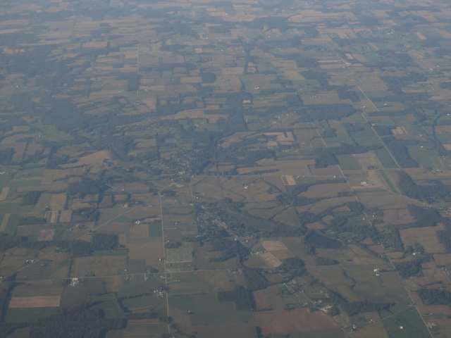
Photo: Ken Lund (Flickr, via Wikimedia Commons), CC BY-SA 2.0 · Wikimedia Commons
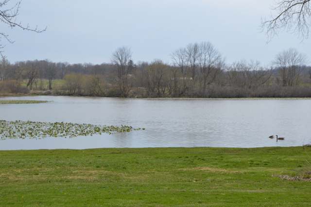
Photo: Nyttend, public domain · Wikimedia Commons
Local history sources: en.wikipedia.org · en.wikipedia.org · genealogytrails.com · commons.wikimedia.org · commons.wikimedia.org · en.wikipedia.org · archive.org · archive.org · archive.org · archive.org · en.wikipedia.org · archive.org · commons.wikimedia.org
Water
Wells (14 listed as active in EPA SDWIS: Wells 1-7 and 10-15; Well 9 was deactivated 2025-11-17) in the Jerome Fork Basin sand-and-gravel aquifer, sited generally north of the treatment plant on Cleveland Road The water here
- Ashland City92% of residentsJerome Fork Basin sand-and-gravel aquifer (wells)
- Rural Lorain Co. Water A6% of residentsMostly Lake Erie (bought from Avon Lake); some New London Reservoir and Ashland wells
- Bailey Lakes Village2% of residentsLake Erie
- Hayesville Village1% of residentsGroundwater wells (2 wells)
Its ZIP codes
Each ZIP code that touches Bailey Lakes, with the share of its residents who live here and the same headline figures as the ZIP page.
| ZIP | Share | Water | Radon | Home value | Schools | Flood |
|---|---|---|---|---|---|---|
| 44805 Ashland | 1% | Wells (14 listed as active in EPA SDWIS: Wells 1-7 and 10-15; Well 9 was deactivated 2025-11-17) in the Jerome Fork Basin sand-and-gravel aquifer, sited generally north of the treatment plant on Cleveland Road | 5.8 pCi/L average radon | Median year built 1964 | Ashland City · 4 stars overall | 2.6% of residents in the 1% floodplain |
Local government
Who holds office in Bailey Lakes, how its elections and ballot issues came out, and the state auditor's record.
Ballot issues
| Date | Issue | For | Against | Result |
|---|---|---|---|---|
| 2018-11-06 | Issue: Bailey Lakes Village Add 5m RBs (5.0 mills) | 73 | 72 | Passed (50.34% for) |
Elections for office
| Date | Office | Candidates and votes |
|---|---|---|
| 2025-11-04 | Member of Council (unofficial count) | Betty Brown 46, 39.32%; Tina Killion 35, 29.91%; Dorothy Scott 36, 30.77% |
| 2023-11-07 | Member of Council (unofficial count) | Randy Ramsthaler 71, 100.0% |
| 2023-11-07 | Mayor (unofficial count) | John R. Benshoff 92, 100.0% |
| 2021-11-02 | Member of Council | Anne Ramsthaler 35, 20.59%; Courtney Rhoades 44, 25.88%; Dorothy L. Scott 40, 23.53%; Gary Strine 51, 30.0% |
| 2019-11-05 | Mayor | John R. Benshoff 44, 100.0% |
| 2019-11-05 | Council | Cynthia A. Gaubatz 33, 25.58%; Tina Killion 23, 17.83%; Jeffrey D. Ling 39, 30.23%; Randy Ramsthaler 34, 26.36% |
| 2017-11-07 | Council | Mary Webb Dilgard 56, 28.0%; Tom Metzger 43, 21.5%; Anne Ramsthaler 44, 22.0%; Dorothy Scott 57, 28.5% |
Winners in bold. Results from the county board of elections' official canvass unless marked.
Auditor of State record
- No fiscal caution, watch or emergency on the Auditor of State's lists.
- Basic Audit, 2022 to 2023, released 2024-07-16
The county
Ashland County: 9 ZIP codes, 22 cities, villages and townships, 50,803 people.
Nearby places
Rain and snow
How much has actually fallen on Bailey Lakes, day by day, from 1893 to now. Daily totals, not averages.
- rain, last 30 days
- 2.19 in
- 2026-10-01 to 2026-10-30
- rain so far in 2026
- 36.7 in
- about normal for the date
- snow so far in 2026
- 22.3 in
- a normal year brings 39.8 in
- a normal year
- 41.7 in
- average of 30 years, 1991-2020
| Month | Rain (in) | Snow (in) | Days counted |
|---|---|---|---|
| October 2026 | 2.19 | — | 30 |
| September 2026 | 4.34 | — | 30 |
| August 2026 | 4.20 | — | 31 |
| July 2026 | 2.92 | — | 31 |
| June 2026 | 4.20 | — | 30 |
| May 2026 | 5.59 | — | 31 |
| April 2026 | 7.10 | 0.0 | 30 |
| March 2026 | 3.79 | 0.6 | 31 |
| February 2026 | 0.69 | 4.7 | 28 |
| January 2026 | 1.62 | 17.0 | 31 |
| December 2025 | 2.40 | 9.2 | 31 |
| November 2025 | 1.43 | 1.2 | 30 |
| Wettest year | 2011 — 57.0 in |
|---|---|
| Driest year | 1963 — 22.9 in |
| Snowiest year | 1910 — 64.7 in |
| Wettest day on record | 5 July 1969 — 5.91 in |
| Heaviest snowfall in a day | 8 March 2008 — 11.72 in |
| Deepest snow on the ground | 2 March 1900 — 23.44 in |
Estimated, not measured. No rain gauge has ever stood inside Bailey Lakes, so every figure here is worked out from the gauges around it - the nearest ones weighted most. Treat them as close estimates rather than readings.
48,645 days of records, 1893-01-01 to 2026-10-30. Source: NOAA NCEI GHCN-Daily, 3,240 gauges in and around Ohio. A day is "gauged" when a gauge standing inside the boundary reported it, and the value is the mean of those gauges. Otherwise it is interpolated by inverse distance from every gauge reporting within 50 miles. Nothing is carried forward, back-filled or smoothed. Against NOAA nClimDiv county monthly precipitation over 136,848 complete county-months (checked 2026-11-01): correlation 0.9515, median absolute difference 0.217 in a month. Built 2026-11-01 from the Cracked Buckeye precipitation archive. Snow is the softer number — snowfall is measured by hand with a ruler, no agency publishes a gridded county snowfall series, and blowing snow defeats every observer.
Environmental permits and filings
What Ohio EPA has on file for Bailey Lakes: permits, inspections, violations, cleanups and the state loans behind sewer and water work. Every line links to the agency's own document.
- facilities and sites on file
- 3
- those placed on the map inside Bailey Lakes
| Program | Facilities and sites |
|---|---|
| Public drinking water | 1 |
| Sewer and water-line construction | 1 |
| State water loans | 1 |
| Date | Facility or site | What |
|---|---|---|
| BAILEY LAKES VILLAGE PWS | Public drinking water report | |
| BAILEY LAKES VILLAGE PWS | Public drinking water plan | |
| BAILEY LAKES VILLAGE PWS | Public drinking water inspection | |
| BAILEY LAKES VILLAGE PWS | Public drinking water inspection | |
| BAILEY LAKES VILLAGE PWS | Public drinking water inspection | |
| BAILEY LAKES VILLAGE PWS | Public drinking water compliance letter | |
| BAILEY LAKES VILLAGE PWS | Public drinking water compliance letter | |
| BAILEY LAKES VILLAGE PWS | Public drinking water report | |
| BAILEY LAKES VILLAGE PWS | Public drinking water compliance letter | |
| BAILEY LAKES VILLAGE PWS | Public drinking water report | |
| BAILEY LAKES VILLAGE PWS | Sewer and water-line construction permit | |
| BAILEY LAKES VILLAGE PWS | Public drinking water compliance letter | |
| BAILEY LAKES VILLAGE PWS | Public drinking water permit | |
| BAILEY LAKES VILLAGE PWS | Public drinking water inspection | |
| BAILEY LAKES VILLAGE PWS | Public drinking water compliance letter | |
| BAILEY LAKES VILLAGE PWS | Public drinking water report | |
| BAILEY LAKES VILLAGE PWS | Public drinking water compliance letter | |
| BAILEY LAKES VILLAGE PWS | Public drinking water report | |
| BAILEY LAKES VILLAGE PWS | Public drinking water inspection | |
| BAILEY LAKES VILLAGE PWS | Public drinking water report | |
| BAILEY LAKES VILLAGE PWS | Public drinking water inspection | |
| BAILEY LAKES VILLAGE PWS | Public drinking water inspection | |
| BAILEY LAKES VILLAGE PWS | Public drinking water inspection | |
| BAILEY LAKES VILLAGE PWS | Public drinking water inspection | |
| BAILEY LAKES VILLAGE PWS | Public drinking water report |
Source: Ohio EPA eDocument portal (edocpub.epa.ohio.gov), indexed 2026-10-14. Facilities are placed on the map from Ohio EPA's own map layers, EPA's Facility Registry, coordinates written in the filings, or a geocoded street address. A permit filed under a private person's name (most are household septic systems) is counted but never named, placed or linked; licenses for individual workers and open-burning notices are left out entirely.
Quick answers
What county is Bailey Lakes, Ohio in?
Bailey Lakes is a village in Ashland County, Ohio, with 349 residents.
When was Bailey Lakes, Ohio founded?
Bailey Lakes was incorporated 1961. Source
How did Bailey Lakes, Ohio get its name?
The village takes its name from Bailey Lake, one of the small lakes it surrounds. Source
Where does Bailey Lakes, Ohio get its water?
The main water source for Bailey Lakes (Ashland City): Wells (14 listed as active in EPA SDWIS: Wells 1-7 and 10-15; Well 9 was deactivated 2025-11-17) in the Jerome Fork Basin sand-and-gravel aquifer, sited generally north of the treatment plant on Cleveland Road.
Cite this page
Cite this page as:
Cracked Buckeye, "Bailey Lakes, Ashland County", https://crackedbuckeye.com/place/bailey-lakes/, built 2026-10-31, accessed [date].
How to cite · Report a correction · Built 2026-10-31