Local events in Glendale
Nothing is posted for Glendale itself yet; here is what is on within 10 miles. All local events in Glendale
Know a calendar we should watch? Send the link
Checked October 20; the events page is refreshed daily.
How Glendale began
Glendale was laid out in 1851-52 by the Glendale Association, a joint-stock company of about thirty Cincinnati men (George Crawford and Henry Clark were its trustees) who bought some 565 to 600 acres of farmland on the new Cincinnati, Hamilton and Dayton Railroad. Civil engineer Robert C. Phillips surveyed 200 acres in curving avenues, three parks and a lake on rural-cemetery principles, one of the earliest planned residential suburbs in the United States, and buyers had to become residents. The village was incorporated in 1855; its first institution was the Glendale Female College (founded 1854 in the original summer hotel), and its churches followed from 1855. Morgan's raiders rode through in July 1863, and fires in 1880 destroyed much of the business district. The Glendale Historic District was listed on the National Register on July 20, 1976 and became a National Historic Landmark on May 5, 1977. A prehistoric mound, Mathew Mound, stands on a hill north of Oak Road, and the village had 2,298 residents in 2020.
Settled 1792 (a station on Mill Creek just below the later village), platted 1851-52, incorporated 1855, by The Glendale Association (about 30 Cincinnati investors, with George Crawford and Henry Clark as trustees); Robert C. Phillips, civil engineer.
Where the name comes from
No source consulted documents the specific origin of the name "Glendale" for the village.
Before the town
Glendale holds Mathew Mound, a prehistoric earthwork atop a hill on the northern side of Oak Road within the village. No source consulted gives a cultural attribution or date range for it. The 1881 history of Hamilton County describes other mounds in Springfield Township, in which Glendale lies, all attributed there to the 'Mound Builders': a large mound near the Station spring, destroyed in grading a turnpike, whose earth was found laid in small heaps of different soils; one on the Maynard French farm southwest of Glendale, 73 by 63 feet at the base and 8 feet high; a smaller one, 40 feet across and 6 feet high, on the Noah Babb place; and several on the estate of John L. Riddle, one of the farmers from whom the Glendale Association bought land. No enclosures or fortified works had been found in the township. In the 1790s the valley of Mill Creek was a corridor of settler stations and military roads: a company led by Henry Tucker built a block-house in 1792 on a military trace cut between Forts Washington and Hamilton, at a place just below the later village. No historic-era Native village, trail or treaty line specific to Glendale was found.
- Mathew Mound (mound) — Atop the hill on the northern side of Oak Road, Glendale village, Hamilton County, not specified in sources consulted (en.wikipedia.org)
- Mound on the Maynard French farm (mound) — Section 11, southwest of Glendale, Springfield Township, undated; described in 1881 as the work of the Mound Builders (archive.org)
- Mounds on the Babb place and the Riddle estate (mound) — Section 4 (Noah Babb's place) and the northwest of Springfield Township (John L. Riddle's estate), undated; described in 1881 (archive.org)
Timeline
- — A company of Henry Tucker, Henry Weaver, Luke and Zebulon Foster and others builds a station and block-house on the west branch of Mill Creek, a little below the site of Glendale, on the military trace cut between Forts Washington and Hamilton; the place is remembered as Foster's Hill.
- — The Cincinnati, Hamilton and Dayton Railroad, the first line through northern Hamilton County, is completed; the Glendale Association, a joint-stock company of about thirty Cincinnati men with George Crawford and Henry Clark as trustees, buys 565 to 600 acres from the Glenn, Cochran, Riddle and Watson farms, and surveyor Robert C. Phillips lays out 200 acres on rural-cemetery principles.
- — The village is laid out; among its first settlers are Robert and Henry Clarke, Mr. Glenn, Benjamin Stenell, Fenton Lawson and Robert Crawford, soon joined by Stanley Matthews and Anthony Harkness. The company dams a spring to make a four-acre lake and builds a hotel for summer boarders.
- — The original wooden railroad depot is destroyed by fire.
- — Rev. John Covert opens the American Female College in the former hotel, which the railroad company had acquired; in 1857 the new management renames it Glendale Female College.
- — Glendale is incorporated as a village; the First Presbyterian Church is organized on November 29 in the college chapel.
- — St. Gabriel's Catholic Church is organized and builds a brick church on land given by Gross and Dietrick; the Presbyterian and New Jerusalem (Swedenborgian) churches build their own houses of worship in 1860.
- — Glendale has 690 inhabitants; 1,780 in 1870.
- — Confederate cavalry under John Hunt Morgan ride through Glendale on their raid across southern Ohio; the depot museum preserves memorabilia of the episode.
- — Christ Episcopal Church is organized under Rev. J. B. Pratt; its $20,000 church at the top of the hill south of Sharon Avenue is first used on May 30, 1869.
- — The Glendale Building and Loan Association is incorporated.
- — The village streets, first lit by coal-oil lamps, are fitted with natural-gas lighting, and the fixtures are still in use.
- — The Cincinnati, Hamilton and Dayton depot is built to replace the 1854 structure.
- — A fire on a windy afternoon, with no engine at hand, does about $30,000 of damage; another on August 17 does $25,000 more.
- — Glendale Heritage Preservation is founded after residents find that property development has no safeguards; the museum opens in the restored depot in May 1997.
- — The Glendale Historic District is added to the National Register of Historic Places on July 20.
- — The Glendale Historic District is designated a National Historic Landmark on May 5.
- — The census counts 2,298 people in Glendale.
Stories
A cemetery designer's curves become a commuter suburb
When George Crawford and Henry Clark set out in 1851 to build a residential development along the new Cincinnati, Hamilton and Dayton Railway, they did not lay down a conventional street grid. Civil engineer Robert Phillips planned the 200-acre core using the same design principles then fashionable for rural cemeteries such as Spring Grove in Cincinnati: shaded, winding lanes that followed the natural contour of the land rather than cutting across it. The railroad made the arrangement practical in a way it could not have been a generation earlier, letting Glendale's residents commute into Cincinnati by train while living on curving streets meant to feel more like a park than a subdivision, an approach so early and so well preserved that the resulting Glendale Historic District became a National Historic Landmark in 1977, one of the earliest known planned suburbs in the country still substantially intact.
A hotel that became a college
The Glendale Association built a hotel for summer boarders in its new suburb, but business never matched hopes and the building passed to the railroad company, which sold it in 1854 to the Rev. John Covert. He opened it that September as the American Female College. In 1856 he handed it to Rev. J. G. Monfort and Rev. S. S. and L. D. Potter, who renamed it Glendale Female College the next year; a fire that summer destroyed the chapel and a music building, but classes opened on schedule and steam heating, a novelty, was installed. The school claimed to be the first in the country to give women the freshman, sophomore, junior and senior classification used for men, and by 1879 it had graduated 201 women. Its chapel was also Glendale's first church: the Presbyterian congregation organized there on November 29, 1855, and villagers of all denominations worshipped with the college for six years. In 1879-80 it enrolled 83 students, from Ohio and Indiana and as far away as New Mexico and Russia.
The Eliza House and John Van Zandt
Glendale Heritage Preservation says local tradition counts the village as a station on the Underground Railroad, though it admits there is little hard evidence naming the families involved, and that the only documented case is that of John Van Zandt. Van Zandt, a former Kentucky slaveholder turned abolitionist, was the model for John Van Tromp, the Ohio farmer who shelters Eliza in Harriet Beecher Stowe's Uncle Tom's Cabin, and his house is known locally as the Eliza House. The Supreme Court case that bears his name, Jones v. Van Zandt, arose when slavecatchers stopped his wagon at about three on a Sunday morning and seized several people hidden in it. Salmon P. Chase and William H. Seward were among his lawyers, but in March 1847 the Supreme Court unanimously held the Fugitive Slave Act of 1793 constitutional. The Heritage Preservation museum in the restored depot is open on Thursdays and Saturdays.
Photographs
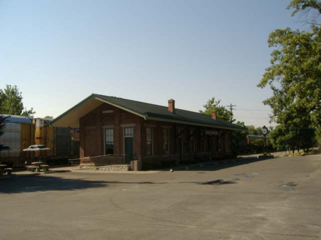
Photo: Bedford, public domain · Wikimedia Commons
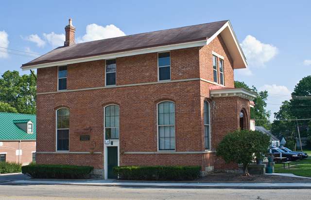
Photo: Greg Hume, CC BY-SA 3.0 · Wikimedia Commons
Local history sources: en.wikipedia.org · en.wikipedia.org · en.wikipedia.org · commons.wikimedia.org · commons.wikimedia.org · glendaleheritage.org · archive.org · glendaleheritage.org · glendaleheritage.org · glendaleheritage.org · glendaleheritage.org · en.wikipedia.org · glendaleheritage.org
Historic places
1 place in Glendale on the National Register of Historic Places. Press a pin or a name for its whole record.
-
Glendale Police StationBuilding · Glendale · listed 1975
- Address
- 305 E. Sharon Ave.
- Where
- Glendale, Hamilton County · ZIP 45246
- What it is
- Building
- Listed on the National Register
- 1975
- NRIS reference number
- 75001425
- Coordinates
- 39.27185, -84.45819
National Register file (NPS) ↗ Search Wikipedia ↗ Street map and directions ↗ On the Cracked Buckeye map
Source: National Park Service, National Register of Historic Places point file. The listing year is shown where NPS's certification date agrees with the listing's reference number. Listing recognizes significance; it does not restrict a private owner.
Water
13 wells in the Great Miami Buried Valley Aquifer along the Great Miami River near Fairfield, Butler Co. The water here
- Cincinnati Public Water System85% of residentsOhio River (Miller Plant, ~88%) plus Great Miami Buried Valley Aquifer wells (~12%)
- Glendale Village15% of residentsGroundwater wells (2 wells)
- Butler Co. Water District 20% of residentsHamilton wells (Great Miami aquifer) + Cincinnati (Ohio River + wells)
Hospitals, fire stations and more
Inside Glendale's boundary: 1 fire or EMS station, 1 public school, 2 private schools, 1 museum, 1 police station and 4 spill cases. Press a pin or a name for its whole record and its source.
Fire and EMS stations (1)
-
Glendale Fire Department Station 45Glendale
- Address
- 80 East Sharon Road, Glendale, OH 45246
- Coordinates
- 39.27294, -84.46544
USGS National Map structures (source) ↗ Street map and directions ↗
Source: USGS National Map structures (most Ohio records last updated 2019 to 2022), checked against the Columbus and Cleveland station lists. The department that answers a call is set by jurisdiction and mutual aid, not by distance.
Public schools (1)
-
Glendale Elementary School3 of 5 stars · Cincinnati
- Address
- 930 Congress Ave, Cincinnati, OH 45246
- School district
- Princeton City School District
- Kind (NCES)
- Regular School
- Students, 2023-24
- 240
- Teachers (full-time equivalent)
- 17
- Report card, 2025-26
- 3 of 5 stars
- Performance index
- 66.8%
- Ohio building IRN
- 013581
- NCES school ID
- 390446701550
NCES school record ↗ Ohio School Report Card ↗ Street map and directions ↗
Source: NCES EDGE public school locations 2024-25 and Common Core of Data 2023-24 (type, students, teachers); Ohio School Report Cards 2025-26 (Department of Education and Workforce), matched by name within the district.
Private schools (2)
-
Bethany SchoolPrivate, religious, denomination-affiliated · Cincinnati
- Address
- 555 Albion Ave, Cincinnati, OH 45246
- Kind
- religious, denomination-affiliated
- Students, 2023-24
- 161
- Teachers (full-time equivalent)
- 29.8
- Students per teacher
- 5.40268
- Phone
- (513) 771-7462
- NCES private school ID
- 01063773
-
St Gabriel Consolidated SchoolPrivate, Catholic · Cincinnati
- Address
- 18 W Sharon Rd, Cincinnati, OH 45246
- Kind
- Catholic
- Students, 2023-24
- 268
- Teachers (full-time equivalent)
- 20.1
- Students per teacher
- 13.3333
- Phone
- (513) 771-5220
- NCES private school ID
- 01055365
Source: NCES Private School Survey 2023-24.
Museums, historical societies, gardens and zoos (1)
-
Glendale Heritage PreservationHistorical society · Glendale
- What it is
- Historical society
- City
- Glendale
- Coordinates
- 39.27084, -84.45930
Search Wikipedia ↗ IMLS Museum Data Files (source) ↗ Street map and directions ↗
The museum list is IMLS's 2018 file; a museum may have closed or moved since.
Source: IMLS Museum Data Files, 2018.
Police stations (1)
-
Glendale Police DepartmentGlendale
- Address
- 301 East Sharon Road, Glendale, OH 45246
- Coordinates
- 39.27191, -84.45812
USGS National Map structures (source) ↗ Street map and directions ↗
Source: USGS National Map structures, police stations, corrected and completed by hand (September 2026). The department that answers a call is set by jurisdiction, not by distance.
Spills reported since 2021 (4)
-
Paint Nos / Lacquer (Not Specified)2023-09-13 · Glendale
- Reported
- 2023-09-13
- What spilled
- Paint Nos / Lacquer (Not Specified)
- Where
- Glendale, Hamilton County
- Ohio EPA district office
- SWDO
- Ohio EPA case number
- 2309EPA0001603
Ohio EPA spill reports (source) ↗ Street map and directions ↗
-
Latex Reached water2023-08-18 · Glendale
- Reported
- 2023-08-18
- What spilled
- Latex; Paint Nos / Lacquer (Not Specified)
- Reached a waterway
- Unnamed
- Where
- Glendale, Hamilton County
- Ohio EPA district office
- SWDO
- Ohio EPA case number
- 2308EPA0001433
Ohio EPA spill reports (source) ↗ Street map and directions ↗
-
Material Unknown2021-07-29 · Glendale
- Reported
- 2021-07-29
- What spilled
- Material Unknown
- Where
- Glendale, Hamilton County
- Ohio EPA district office
- SWDO
- Ohio EPA case number
- 2107EPA0001153
Ohio EPA spill reports (source) ↗ Street map and directions ↗
-
Sheen Rainbow / Hydrocarbon2021-05-20 · Glendale
- Reported
- 2021-05-20
- What spilled
- Sheen Rainbow / Hydrocarbon
- Where
- Glendale, Hamilton County
- Ohio EPA district office
- SWDO
- Ohio EPA case number
- 2105EPA0000709
Ohio EPA spill reports (source) ↗ Street map and directions ↗
Source: Ohio EPA emergency response spill reports, 2021 to September 2026, one point per case where Ohio EPA placed it. A report is what the caller or responder recorded; amounts are often blank or estimated.
Its ZIP codes
Each ZIP code that touches Glendale, with the share of its residents who live here and the same headline figures as the ZIP page.
| ZIP | Share | Water | Radon | Home value | Schools | Flood |
|---|---|---|---|---|---|---|
| 45246 Springdale and Cincinnati | 15% | 13 wells in the Great Miami Buried Valley Aquifer along the Great Miami River near Fairfield, Butler Co. | 2.3 pCi/L average radon | Median year built 1961 | Princeton City · 4 stars overall | 0.9% of residents in the 1% floodplain |
Local government
How its elections and ballot issues came out and the state auditor's record.
Money issues on the ballot since 2020: 5 of 5 passed; of those asking for new or higher taxes, 2 of 2.
Ballot issues
| Date | Issue | For | Against | Result |
|---|---|---|---|---|
| 2025-11-04 | Issue 12: PROPOSED TAX LEVY (ADDITIONAL) VILLAGE OF GLENDALE | 494 | 376 | Passed (56.78% for) |
| 2024-11-05 | Issue 13: PROPOSED TAX LEVY (RENEWAL) VILLAGE OF GLENDALE | 1,157 | 495 | Passed (70.04% for) |
| 2022-11-08 | Issue 21: PROPOSED TAX LEVY (RENEWAL) VILLAGE OF GLENDALE | 1,058 | 372 | Passed (73.99% for) |
| 2022-11-08 | Issue 22: PROPOSED TAX LEVY (ADDITIONAL) VILLAGE OF GLENDALE | 799 | 625 | Passed (56.11% for) |
| 2020-11-03 | Issue 9: PROPOSED TAX LEVY (RENEWAL) VILLAGE OF GLENDALE | 1,202 | 538 | Passed (69.08% for) |
Elections for office
| Date | Office | Candidates and votes |
|---|---|---|
| 2025-11-04 | Member of Council | Amy Baldridge 525, 27.99%; Joan Verchot 509, 27.13%; Jeffrey H. Witte 432, 23.03%; Jon Pischl 410, 21.86% |
| 2023-11-07 | Member of Council | Will Kreidler 769, 51.4%; Amy L. Flury 727, 48.6% |
| 2023-11-07 | Mayor | Mike Besl 826, 62.96%; Marilyn A. Duke 350, 26.68%; Jenny Kilgore 136, 10.37% |
| 2021-11-02 | Treasurer | Michael Beaugrand 440, 54.59%; Leslie A. Cooper 366, 45.41% |
| 2021-11-02 | Member of Council | Mike Besl 581, 21.1%; Nancy A. Macenko 523, 19.0%; Amy C. Baldridge 472, 17.14%; Geoffrey L. Base-Smith 423, 15.37%; Ron Visscher 421, 15.29%; Alan E. Hoeweler 333, 12.1% |
| 2021-11-02 | Clerk | Rebecca M. Terrell 594, 100.0% |
Winners in bold. Results from the county board of elections' official canvass unless marked. The county's results on file run through 2025-11-04; later elections are not loaded yet.
Auditor of State record
- No fiscal caution, watch or emergency on the Auditor of State's lists.
- Financial Audit, 2023, released 2024-12-05
On the November 3, 2026 ballot
Statewide question: State Issue 3: Voter ID
Local questions for Glendale, Hamilton County and its school district:
- Glendale Village: Renews a 2.5-mill property tax levy for the current expenses of Glendale Village for 4 years, beginning in 2026.
- Glendale Village: Renews a 8.5-mill property tax levy for the current expenses of Glendale Village for 4 years, beginning in 2026.
- Hamilton County: Renews and increases a 5.61-mill property tax levy for the care & placement of children & children services of Hamilton County for 4 years, beginning in 2026.
Races, candidates and every question for an address: your ballot. County offices and judges are on your county board's sample ballot.
The county
Hamilton County: 54 ZIP codes, 47 cities, villages and townships with pages here, 838,418 people (Census Bureau estimate, July 2025).
Nearby places
Rain and snow
How much has actually fallen on Glendale, day by day, from 1893 to now. Daily totals, not averages.
- rain, last 30 days
- 1.16 in
- 2026-10-01 to 2026-10-30
- rain so far in 2026
- 44.6 in
- 5.1 in above normal for the date
- snow so far in 2026
- 13.7 in
- a normal year brings 13.2 in
- a normal year
- 46.7 in
- average of 30 years, 1991-2020
| Month | Rain (in) | Snow (in) | Days counted |
|---|---|---|---|
| October 2026 | 1.16 | — | 30 |
| September 2026 | 6.41 | — | 30 |
| August 2026 | 6.27 | — | 31 |
| July 2026 | 4.20 | — | 31 |
| June 2026 | 5.87 | — | 30 |
| May 2026 | 7.26 | — | 31 |
| April 2026 | 3.47 | — | 30 |
| March 2026 | 7.07 | 0.3 | 31 |
| February 2026 | 1.24 | 3.4 | 28 |
| January 2026 | 1.61 | 10.1 | 31 |
| December 2025 | 2.49 | 11.9 | 31 |
| November 2025 | 3.88 | 2.1 | 30 |
| Driest year (estimated) | 1934 — 21.5 in |
|---|---|
| Wettest day (estimated) | 16 May 1996 — 4.67 in |
| Heaviest snowfall in a day (estimated) | 6 January 1910 — 10.00 in |
| Deepest snow on the ground (estimated) | 20 December 1919 — 21.40 in |
Mostly estimated. Only 1% of these days come from a gauge standing inside Glendale - the rest are worked out from the nearest gauges around it, so read them as close estimates rather than readings.
48,117 days of records, 1893-01-01 to 2026-10-30. Source: NOAA NCEI GHCN-Daily, 3,240 gauges in and around Ohio. A day is "gauged" when a gauge standing inside the boundary reported it, and the value is the mean of those gauges. Otherwise it is interpolated by inverse distance from every gauge reporting within 50 miles. Nothing is carried forward, back-filled or smoothed. Against NOAA nClimDiv county monthly precipitation over 136,848 complete county-months (checked 2026-11-01): correlation 0.9515, median absolute difference 0.217 in a month. Built 2026-11-01 from the Cracked Buckeye precipitation archive. Snow is the softer number — snowfall is measured by hand with a ruler, no agency publishes a gridded county snowfall series, and blowing snow defeats every observer.
Environmental permits and filings
What Ohio EPA has on file for Glendale: permits, inspections, violations, cleanups and the state loans behind sewer and water work. Every line links to the agency's own document.
- facilities and sites on file
- 7
- those placed on the map inside Glendale
| Program | Facilities and sites |
|---|---|
| State water loans | 2 |
| Composting | 1 |
| Public drinking water | 1 |
| Site assessment | 1 |
| Source-water protection | 1 |
| State sewer loans | 1 |
| Date | Facility or site | What |
|---|---|---|
| GLENDALE VILLAGE PWS | Public drinking water compliance letter | |
| GLENDALE VILLAGE PWS | Public drinking water report | |
| GLENDALE VILLAGE PWS | Public drinking water notice of violation | |
| GLENDALE VILLAGE PWS | Public drinking water plan | |
| GLENDALE VILLAGE PWS | Public drinking water inspection | |
| GLENDALE COMPOSTING FACILITY | Composting inspection | |
| GLENDALE COMPOSTING FACILITY | Composting report | |
| GLENDALE VILLAGE PWS | Source-water protection report | |
| GLENDALE VILLAGE PWS | Public drinking water inspection | |
| GLENDALE VILLAGE PWS | Public drinking water compliance letter | |
| GLENDALE VILLAGE PWS | Public drinking water report | |
| GLENDALE COMPOSTING FACILITY | Composting inspection | |
| GLENDALE VILLAGE PWS | Public drinking water compliance letter | |
| GLENDALE COMPOSTING FACILITY | Composting report | |
| GLENDALE VILLAGE PWS | Public drinking water inspection | |
| GLENDALE VILLAGE PWS | State water loans | |
| GLENDALE VILLAGE PWS | State water loans | |
| GLENDALE VILLAGE PWS | State water loans | |
| GLENDALE VILLAGE PWS | State water loans | |
| GLENDALE VILLAGE PWS | State water loans | |
| GLENDALE VILLAGE PWS | Public drinking water notice of violation | |
| GLENDALE COMPOSTING FACILITY | Composting inspection | |
| GLENDALE VILLAGE PWS | Public drinking water compliance letter | |
| GLENDALE VILLAGE PWS | Public drinking water inspection | |
| GLENDALE COMPOSTING FACILITY | Composting report |
Source: Ohio EPA eDocument portal (edocpub.epa.ohio.gov), indexed 2026-10-14. Facilities are placed on the map from Ohio EPA's own map layers, EPA's Facility Registry, coordinates written in the filings, or a geocoded street address. A permit filed under a private person's name (most are household septic systems) is counted but never named, placed or linked; licenses for individual workers and open-burning notices are left out entirely.
Quick answers
What county is Glendale, Ohio in?
Glendale is a village in Hamilton County, Ohio, with 2,298 residents.
When was Glendale, Ohio founded?
Glendale was settled 1792 (a station on Mill Creek just below the later village); laid out 1851-52; incorporated 1855. Founders on record: The Glendale Association (about 30 Cincinnati investors, with George Crawford and Henry Clark as trustees); Robert C. Phillips, civil engineer. Source
What ZIP code is Glendale, Ohio?
Most of Glendale is in ZIP code 45246.
Where does Glendale, Ohio get its water?
The main water source for Glendale (Cincinnati Public Water System): 13 wells in the Great Miami Buried Valley Aquifer along the Great Miami River near Fairfield, Butler Co.
Cite this page
Cite this page as:
Cracked Buckeye, "Glendale, Hamilton County", https://crackedbuckeye.com/place/glendale/, built 2026-10-31, accessed [date].
How to cite · Report a correction · Built 2026-10-31