Local events in Magnolia
Nothing is posted for Magnolia itself yet; here is what is on within 10 miles. All local events in Magnolia
Know a calendar we should watch? Send the link
Checked October 20; the events page is refreshed daily.
How Magnolia began
Magnolia was laid out in 1834 by Richard Elson and John W. Smith in Sandy Township and took its name from their Magnolia Mills; Elson and Smith started the water-powered mill that year and the Elson family kept milling there into the 1900s. The county line splits the old village: the Carroll County half was laid out by Isaac Miller as Downingville in 1836 (Perrin's 1881 history says he named it for his son-in-law James Downing; Wikipedia says for the Downes family), and the two halves merged on February 1, 1846. Isaac Miller had kept a tavern and ferry at the Sandy Creek crossing here since about 1806, and the village had a brief boom while the Sandy & Beaver Canal ran. Magnolia counted 431 residents in 1900, peaked at 1,064 in 1970 and had 1,013 in 2020; the Muskingum Watershed Conservancy District's Magnolia Levee protects it from flooding tied to the Bolivar Dam.
Settled 1834, platted 1834 (Magnolia); 1836 (Downingville), incorporated merged February 1, 1846, by Richard Elson and John W. Smith (Magnolia); Isaac Miller (Downingville).
Where the name comes from
The village took its name from Magnolia Mills, the gristmill Richard Elson and John W. Smith built when they laid out the village in 1834. The separate settlement of Downingville, later merged into Magnolia, was named for the Downes family, early pioneers who had come from Ireland and England.
Before the town
No Native village, mound or treaty site is recorded inside Magnolia itself. Perrin's 1881 county history says the old Tuscarawas trail ran west along the valley of the Big Sandy through this township, that Indian Run, flowing through the middle of Sandy Township, was a favorite camping place of Native people who made the neighborhood a home or hunting ground, and that Wyandot families camped by a stream just east of the Sandy Township line until they left in the fall of 1811. The land was ceded by the Treaty of Greenville (1795).
Nations recorded here: Wyandot.
- Tuscarawas trail along the Big Sandy valley (trail) — Sandy Township, along Big Sandy Creek past the future site of Magnolia, before 1800 (archive.org)
Timeline
- — Surveyors under Thomas Hutchins complete the Geographer's Line near the future site of Magnolia in September, marking the western terminus of the Seven Ranges, the first systematically surveyed public land in the United States.
- — Isaac Miller settles on the west side of Big Sandy Creek close to the future site of Magnolia, where he opens a house of entertainment and runs a ferry for emigrants crossing the creek.
- — The first schoolhouse in Sandy Township is built on the W. H. Knotts farm west of Magnolia (Perrin says 1809 or 1810), with William Lee as first teacher.
- — Isaac Miller builds a toll bridge over the Sandy beside his ferry, the first bridge across that creek.
- — Richard Elson and John W. Smith lay out the village of Magnolia in Sandy Township, named for their Magnolia Mills gristmill.
- — Patrick Call builds the village iron foundry near the present Elson residence (Perrin says 1834 or 1835); he moves it to Waynesburg in 1845.
- — Elson & Smith establish their water-power mill, later the A. R. Elson mill with saw mill and woodworking machinery, which Perrin calls one of the finest water-power plants in that part of Ohio.
- — Isaac Miller platts the separate settlement of Downingville in Rose Township.
- — Magnolia and Downingville merge into a single village on February 1.
- — Perrin's county history counts about 300 people in Magnolia, with two churches (United Brethren in Christ and Evangelical Lutheran), hotels, a harness maker and John G. Croxton remembered as keeper of the first store.
- — The census counts 431 residents in Magnolia.
- — The A.R. Elson Co. operates as merchant millers, dealing in lumber and building materials, an advertisement documents.
- — The census counts 685 residents in Magnolia, 819 in 1940 and 901 in 1950.
- — Magnolia reaches its census peak of 1,064 residents, then falls to 937 by 1990 before recovering to 1,013 in 2020.
Stories
Two villages merge, and a mill gives the combined town its name
Magnolia exists today because two separate settlements, platted two years apart by different founders, eventually decided to become one town. Richard Elson and John W. Smith laid out Magnolia in Sandy Township in 1834, naming it for the gristmill, Magnolia Mills, that anchored their settlement. Two years later, Isaac Miller platted a second community nearby in Rose Township, Downingville, named for the Downes family of early Irish and English settlers. Rather than compete indefinitely as neighboring rivals, the two merged into a single Magnolia on February 1, 1846, with the mill-derived name winning out over the family name. The Elson family's milling business outlasted the merger by decades -- an advertisement from 1915 shows the A.R. Elson Co. still operating as merchant millers and lumber dealers, eighty years after Richard Elson's original mill gave the village its name.
The ferryman who outran a Wyandot war party
Isaac Miller, who ran the tavern and ferry at the Sandy crossing by Magnolia from about 1806, had earlier been one of five scouts sent out by Gen. Anthony Wayne's army in the spring of 1793: Capt. James Downing, Miller, John Cuppy, George Foulke and a man named Dillow. As Perrin tells it from Miller's own account, about twenty Wyandot warriors found their camp near present Minerva and split into two parties to attack it. The scouts scattered, Downing and Cuppy fighting a running retreat, while Miller, sure he could outrun the whole party, yelled a taunt to draw them after him and then cleared a creek in a leap. He ran two miles without looking back, slept that night under a fallen chestnut and rejoined the others at the river two days later. Foulke, hiding nearby, watched the Wyandots bury at least two of their dead, one near the site of a house later built in Minerva. All five lived to tell it, and three of them later settled in Sandy Township.
Photographs
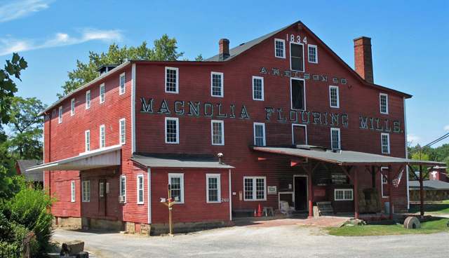
Photo: Sanfranman59, CC BY-SA 3.0 · Wikimedia Commons
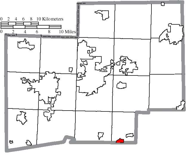
Photo: Ruhrfisch and Nyttend, CC BY-SA 3.0 · Wikimedia Commons
Local history sources: en.wikipedia.org · en.wikipedia.org · en.wikipedia.org · commons.wikimedia.org · commons.wikimedia.org · archive.org
Water
Mostly private wells The water here
- Magnolia Village96% of residentsGroundwater wells (3 wells)
- East Sparta Village4% of residentsGroundwater wells (4 wells)
Hospitals, fire stations and more
Inside Magnolia's boundary: 1 fire or EMS station, 1 museum, 1 police station, 1 shale or injection well and 2 spill cases. Press a pin or a name for its whole record and its source.
Fire and EMS stations (1)
-
Magnolia Volunteer Fire DepartmentMagnolia
- Address
- 125 High Street, Magnolia, OH 44643
- Coordinates
- 40.65434, -81.29291
USGS National Map structures (source) ↗ Street map and directions ↗
Source: USGS National Map structures (most Ohio records last updated 2019 to 2022), checked against the Columbus and Cleveland station lists. The department that answers a call is set by jurisdiction and mutual aid, not by distance.
Museums, historical societies, gardens and zoos (1)
-
Magnolia Area Historical SocietyHistorical society · Magnolia
- What it is
- Historical society
- City
- Magnolia
- Coordinates
- 40.65143, -81.29874
Search Wikipedia ↗ IMLS Museum Data Files (source) ↗ Street map and directions ↗
The museum list is IMLS's 2018 file; a museum may have closed or moved since.
Source: IMLS Museum Data Files, 2018.
Police stations (1)
-
Magnolia Police DepartmentMagnolia
- Address
- 328 North Main Street, Magnolia, OH 44643
- Coordinates
- 40.65376, -81.29825
USGS National Map structures (source) ↗ Street map and directions ↗
Source: USGS National Map structures, police stations, corrected and completed by hand (September 2026). The department that answers a call is set by jurisdiction, not by distance.
Shale and injection wells (1)
-
Lee Unit(Swiw #9) 1-D InjectionInjection well (Class II)
- What it is
- Injection well (Class II)
- Operator
- Ows Acquisition Co Llc
- County
- Carroll County
- API well number
- 34019220450000
- Coordinates
- 40.64729, -81.29420
ODNR oil and gas wells (source) ↗ Street map and directions ↗
Source: ODNR Division of Oil and Gas Resources well inventory (September 2026): drilled Utica, Marcellus and horizontal wells and Class II injection wells not plugged. Older vertical wells are on the full map.
Spills reported since 2021 (2)
-
Material Black2025-08-05 · Magnolia
- Reported
- 2025-08-05
- What spilled
- Material Black
- Where
- Magnolia, Stark County
- Ohio EPA district office
- NEDO
- Ohio EPA case number
- 2508EPA0001320
Ohio EPA spill reports (source) ↗ Street map and directions ↗
-
Oil Transformer Non Pcb2025-06-17 · Magnolia
- Reported
- 2025-06-17
- What spilled
- Oil Transformer Non Pcb
- Where
- Magnolia, Stark County
- Ohio EPA district office
- NEDO
- Ohio EPA case number
- 2506EPA0000992
Ohio EPA spill reports (source) ↗ Street map and directions ↗
Source: Ohio EPA emergency response spill reports, 2021 to September 2026, one point per case where Ohio EPA placed it. A report is what the caller or responder recorded; amounts are often blank or estimated.
Its ZIP codes
Each ZIP code that touches Magnolia, with the share of its residents who live here and the same headline figures as the ZIP page.
| ZIP | Share | Water | Radon | Home value | Schools | Flood |
|---|---|---|---|---|---|---|
| 44643 Magnolia | 31% | Mostly private wells | 11.0 pCi/L average radon | Median year built 1961 | Sandy Valley Local · 3 stars overall | 4.1% of residents in the 1% floodplain |
Local government
Who holds office in Magnolia, how its elections and ballot issues came out, and the state auditor's record.
Who holds office
| Office | Name | Party | Term ends | Contact |
|---|---|---|---|---|
| Clerk-Treasurer | DISSOLVED POSITION | R | 2029-12-31 | 330-268-7087 6-13-2018 Village of Magnolia (Stark & Carroll Counties) Member of Council Downes Grant 559 Main St. Magnolia 44643 330-904-6324 NP 1-1-24 to 12-31-27 Stark Village of Magnolia (Stark & Carroll Counties) Member of Council Noble Scott A. 204 Harrison St. Magnolia 44643 330-904-4052 NP 1-1-24 to 12-31-27 Stark Village of Magnolia (Stark & Carroll Counties) Member of Council Rogers Claudia C. 351 Harrison St. Magnolia 44643 |
| Trustee | of Public Affairs Crowe James s | R | 330-866-2205 496 East Carrolton St. Magnolia 44643 330-324-7869 NP 1-1-24 to 12-31-27 Carroll 8/13/2026, p. 5 of 16 Village of Magnolia appointed 1-1-24 (Stark & Carroll Counties) Member of Board of Trustees of Public Affairs Herstine Jay 171 East Carollton St. Magnolia 44643 |
Roster as of 2026-08-12: county board of elections.
Money issues on the ballot since 2015: 14 of 14 passed.
Ballot issues
| Date | Issue | For | Against | Result |
|---|---|---|---|---|
| 2025-11-04 | Issue: Village of Magnolia | 143 | 39 | Passed (78.57% for) |
| 2024-11-05 | Issue: Village of Magnolia | 273 | 98 | Passed (73.58% for) |
| 2022-11-08 | Issue: Village of Magnolia Current Expenses | 213 | 67 | Passed (76.07% for) |
| 2022-11-08 | Issue: Village of Magnolia Cemetery | 203 | 75 | Passed (73.02% for) |
| 2021-11-02 | Issue: Village of Magnolia Current Expenses 2.0 Mills Renewal | 146 | 38 | Passed (79.35% for) |
| 2021-11-02 | Issue: Village of Magnolia Current Expenses 3.5 Mills Renewal | 142 | 44 | Passed (76.34% for) |
| 2021-11-02 | Issue: Village of Magnolia Police 4.0 Mills Renewal | 138 | 46 | Passed (75.0% for) |
| 2021-05-04 | Issue: Village of Magnolia, Current Expenses | 61 | 13 | Passed (82.43% for) |
| 2019-11-05 | Issue: Village of Magnolia Fire | 166 | 44 | Passed (79.05% for) |
| 2017-11-07 | Issue: Village of Magnolia, Cemetery | 119 | 39 | Passed (75.32% for) |
| 2017-11-07 | Issue: Village of Magnolia, Current Expenses | 118 | 41 | Passed (74.21% for) |
| 2016-11-08 | Issue: Village of Magnolia, Gas Aggregation | 246 | 87 | Passed (73.87% for) |
| 2016-11-08 | Issue: Village of Magnolia, Electric Aggregation | 248 | 81 | Passed (75.38% for) |
| 2016-11-08 | Issue: Village of Magnolia, Police | 268 | 76 | Passed (77.91% for) |
| 2016-11-08 | Issue: Village of Magnolia, Current Expenses | 247 | 92 | Passed (72.86% for) |
| 2016-11-08 | Issue: Village of Magnolia, Current Expenses | 250 | 88 | Passed (73.96% for) |
| 2015-11-03 | Issue: Village of Magnolia Fire | 159 | 109 | Passed (59.33% for) |
| 2015-11-03 | Issue: Village of Magnolia Current Expenses | 202 | 65 | Passed (75.66% for) |
Elections for office
| Date | Office | Candidates and votes |
|---|---|---|
| 2025-11-04 | Member of Council | Claudia C. Rogers 149, 100.0%; No Valid Petition Filed 0; No Valid Petition Filed 0; No Valid Petition Filed 0 |
| 2025-11-04 | Board of Public Affairs | No Valid Petition Filed 0 |
| 2023-11-07 | Mayor | Travis M. Boyd 230, 100.0% |
| 2023-11-07 | Council | Grant Downes 201, 54.32%; Scott A. Noble 169, 45.68% |
| 2023-11-07 | Board of Public Affairs | No Valid Petition Filed 0; No Valid Petition Filed 0 |
| 2021-11-02 | Council (number of seats not on file, so winners are not marked) | Claudia C. Rogers 146, 100.0%; No Valid Petition Filed 0; No Valid Petition Filed 0; No Valid Petition Filed 0 |
| 2021-11-02 | Board of Public Affairs | No Valid Petition Filed 0 |
| 2019-11-05 | Mayor | Travis M. Boyd 102, 48.8%; Grant Downes 100, 47.85%; Kalvin J. Kampfer 7, 3.35% |
| 2019-11-05 | Council | Scott A. Noble 161, 100.0% |
| 2017-11-07 | Council (number of seats not on file, so winners are not marked) | Jessica Irwin-Miller 117, 24.68%; James Alan Miller 119, 25.11%; Claudia C. Rogers 113, 23.84%; Eric T. White 125, 26.37% |
| 2015-11-03 | Mayor | Robert Leach 241, 100.0% |
| 2015-11-03 | Council (number of seats not on file, so winners are not marked) | Riley Benson 129, 31.16%; Grant Downes 150, 36.23%; James R. Hunter 135, 32.61% |
| 2015-11-03 | Clerk-Treasurer | Lorrie R. Clevenger 240, 100.0% |
Winners in bold. Results from the county board of elections' official canvass unless marked.
Auditor of State record
- No fiscal caution, watch or emergency on the Auditor of State's lists.
- Financial Audit, 2022 to 2023, released 2025-05-08
The county
Stark County: 34 ZIP codes, 36 cities, villages and townships, 374,115 people.
Nearby places
Rain and snow
How much has actually fallen on Magnolia, day by day, from 1893 to now. Daily totals, not averages.
- rain, last 30 days
- 1.24 in
- 2026-09-30 to 2026-10-29
- rain so far in 2026
- 37.6 in
- 2.2 in above normal for the date
- snow so far in 2026
- 27.3 in
- a normal year brings 30.6 in
- a normal year
- 41.6 in
- average of 30 years, 1991-2020
| Month | Rain (in) | Snow (in) | Days counted |
|---|---|---|---|
| October 2026 | 1.24 | — | 29 |
| September 2026 | 4.55 | — | 30 |
| August 2026 | 6.05 | — | 31 |
| July 2026 | 4.04 | — | 31 |
| June 2026 | 3.03 | — | 30 |
| May 2026 | 5.23 | — | 31 |
| April 2026 | 5.30 | 0.1 | 30 |
| March 2026 | 5.12 | 2.3 | 31 |
| February 2026 | 1.10 | 4.3 | 28 |
| January 2026 | 1.99 | 20.7 | 31 |
| December 2025 | 2.50 | 11.4 | 31 |
| November 2025 | 1.89 | 0.3 | 30 |
| Wettest year | 2011 — 55.9 in |
|---|---|
| Driest year | 1963 — 26.6 in |
| Snowiest year | 1910 — 67.3 in |
| Wettest day on record | 5 July 1969 — 4.26 in |
| Heaviest snowfall in a day | 20 April 1901 — 14.31 in |
| Deepest snow on the ground | 27 November 1950 — 18.58 in |
Mostly estimated. Only 4% of these days come from a gauge standing inside Magnolia - the rest are worked out from the nearest gauges around it, so read them as close estimates rather than readings.
48,751 days of records, 1893-01-01 to 2026-10-29. Source: NOAA NCEI GHCN-Daily, 3,240 gauges in and around Ohio. A day is "gauged" when a gauge standing inside the boundary reported it, and the value is the mean of those gauges. Otherwise it is interpolated by inverse distance from every gauge reporting within 50 miles. Nothing is carried forward, back-filled or smoothed. Against NOAA nClimDiv county monthly precipitation over 136,848 complete county-months (checked 2026-10-31): correlation 0.9515, median absolute difference 0.217 in a month. Built 2026-10-31 from the Cracked Buckeye precipitation archive. Snow is the softer number — snowfall is measured by hand with a ruler, no agency publishes a gridded county snowfall series, and blowing snow defeats every observer.
Quick answers
What county is Magnolia, Ohio in?
Magnolia is a village in Stark County, Ohio, with 1,013 residents.
When was Magnolia, Ohio founded?
Magnolia was settled 1834; laid out 1834 (Magnolia); 1836 (Downingville); incorporated merged February 1, 1846. Founders on record: Richard Elson and John W. Smith (Magnolia); Isaac Miller (Downingville). Source
How did Magnolia, Ohio get its name?
The village took its name from Magnolia Mills, the gristmill Richard Elson and John W. Source
What ZIP code is Magnolia, Ohio?
Most of Magnolia is in ZIP code 44643.
Where does Magnolia, Ohio get its water?
The main water source for Magnolia (Magnolia Village): Mostly private wells.
Cite this page
Cite this page as:
Cracked Buckeye, "Magnolia, Stark County", https://crackedbuckeye.com/place/magnolia/, built 2026-10-31, accessed [date].
How to cite · Report a correction · Built 2026-10-31
