Local events in Alliance
31 events in the next 90 days from 2 public calendars. All local events in Alliance
Checked October 20; the events page is refreshed daily.
Lakes near Alliance
The history under the water: the valley before, the dam, the stories. All Ohio lakes
History from Alliance
People and inventions tied to this place, each with its sources. All people · All inventions
How Alliance began
Alliance was formed in 1854 by the merger of three older settlements -- Williamsport (1827), Freedom (1838), and Liberty (1850) -- at the junction of the Cleveland and Pittsburgh and the Ohio and Pennsylvania railroads, and incorporated in 1889 after absorbing Mount Union in 1888. The city grew as a railroad and manufacturing town, home to Mount Union College (now the University of Mount Union) and, from 1923, the Alliance Rubber Company. Its municipal water system dates to a 1954 reservoir on Deer Creek, and the current treatment plant opened in 1993.
Settled 1827 (Williamsport, the earliest of the merged settlements), incorporated 1854 (merger); 1889 (city incorporation).
Where the name comes from
Two explanations are commonly given: one holds that 'Alliance' reflects the 1854 union, or alliance, of the three founding settlements (Williamsport, Freedom, and Liberty); the other ties the name to the meeting, or 'alliance,' of the Cleveland and Pittsburgh Railroad and the Ohio and Pennsylvania Railroad at the site then called 'The Crossing.'
Before the town
No Native American village, mound, or treaty site specific to Alliance is documented in the sources consulted. The site lies in the area of Stark County ceded by the Treaty of Greenville (1795).
Nations recorded here: Lenape (Delaware).
Timeline
- — Williamsport is founded, the earliest of the three settlements that later merge into Alliance.
- — Williamsport, Freedom, and Liberty merge to form Alliance as a railroad junction town.
- — A tornado strikes on April 12, tearing roofs off churches and pushing a train off its rails, with an estimated $15,000-$20,000 in damage.
- — Dr. Levi L. Lamborn begins cultivating scarlet carnations in Alliance, a flower later linked to President McKinley and named Ohio's state flower in 1904.
- — Mount Union is added to Alliance in 1888, and the combined city incorporates in 1889.
- — Alliance builds its original sewage treatment plant on Keystone Street, the root of the current wastewater system.
- — The Alliance Rubber Company is founded, manufacturing rubber bands.
- — Deer Creek Reservoir is dedicated October 25 to supply the Alliance Water Treatment Plant.
- — The current 10-million-gallon-per-day Alliance Water Treatment Plant begins operation in July.
Stories
A carnation grown in Alliance becomes Ohio's state flower
In 1866, Alliance physician Levi L. Lamborn began cultivating scarlet carnations, a hobby that might have stayed a private pastime if not for a friendly rivalry with a young local lawyer named William McKinley, who reportedly wore one of Lamborn's carnations for luck. McKinley kept the habit through his rise to the presidency, and after his assassination in 1901 the scarlet carnation became closely associated with his memory. In 1904, the Ohio General Assembly designated the scarlet carnation the official state flower, tracing a line from a doctor's garden in a railroad-junction town to a symbol on the state seal.
Three towns become one at a railroad crossing
Alliance exists because two railroads happened to cross at the same spot. Williamsport, Freedom, and Liberty were three separate, modest settlements strung along what became known as 'The Crossing,' where the Cleveland and Pittsburgh Railroad met the Ohio and Pennsylvania Railroad. In 1854 the three merged into a single town built to serve that junction, and its layout still shows the railroad's priority: Main Street was designed to funnel traffic toward the station, leaving it, unusually, a dead end rather than running through -- a detail residents still point to as a quirk of the city's railroad-first origins.
Photographs
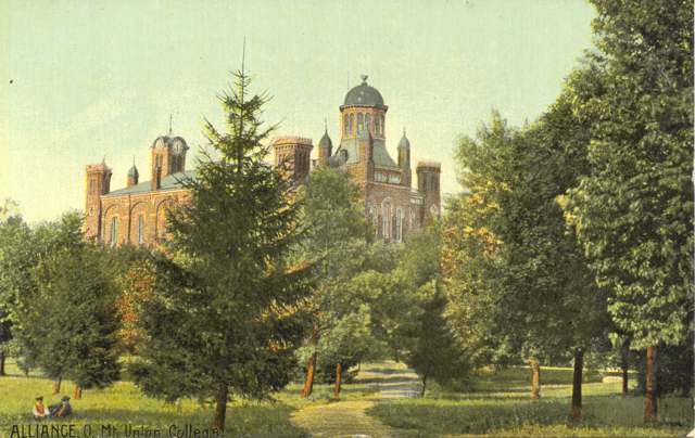
Photo: Miami University Libraries - Digital Collections, no known copyright restrictions · Wikimedia Commons
Local history sources: en.wikipedia.org · en.wikipedia.org · commons.wikimedia.org
Historic places
8 places in Alliance on the National Register of Historic Places. Press a pin or a name for its whole record.
-
Alliance Bank BuildingBuilding · Alliance · listed 1995
- Address
- 502 E. Main St.
- Where
- Alliance, Stark County · ZIP 44601
- What it is
- Building
- Listed on the National Register
- 1995
- NRIS reference number
- 95000940
- Coordinates
- 40.92214, -81.09863
National Register file (NPS) ↗ Search Wikipedia ↗ Street map and directions ↗ On the Cracked Buckeye map
-
City Savings Bank & Trust CompanyBuilding · Alliance · listed 2016
- Address
- 449 E. Main St.
- Where
- Alliance, Stark County · ZIP 44601
- What it is
- Building
- Listed on the National Register
- 2016
- NRIS reference number
- 16000602
- Coordinates
- 40.91966, -81.09919
National Register file (NPS) ↗ Search Wikipedia ↗ Street map and directions ↗ On the Cracked Buckeye map
-
Eagles Building--Strand TheaterBuilding · Alliance · listed 1997
- Address
- 243 E. Main St.
- Where
- Alliance, Stark County · ZIP 44601
- What it is
- Building
- Listed on the National Register
- 1997
- NRIS reference number
- 96001624
- Coordinates
- 40.92159, -81.10267
National Register file (NPS) ↗ Search Wikipedia ↗ Street map and directions ↗ On the Cracked Buckeye map
-
Earley-Hartzell HouseBuilding · Alliance · listed 1987
- Address
- 840 N. Park Ave.
- Where
- Alliance, Stark County · ZIP 44601
- What it is
- Building
- Listed on the National Register
- 1987
- NRIS reference number
- 87002147
- Coordinates
- 40.93024, -81.10446
National Register file (NPS) ↗ Search Wikipedia ↗ Street map and directions ↗ On the Cracked Buckeye map
-
First Methodist Episcopal Church of Alliance, OhioBuilding · Alliance · listed 1985
- Address
- 470 E. Broadway St.
- Where
- Alliance, Stark County · ZIP 44601
- What it is
- Building
- Listed on the National Register
- 1985
- NRIS reference number
- 85000945
- Coordinates
- 40.91943, -81.09934
National Register file (NPS) ↗ Search Wikipedia ↗ Street map and directions ↗ On the Cracked Buckeye map
-
Haines HouseBuilding · Alliance · listed 1974
- Address
- 186 W. Market St.
- Where
- Alliance, Stark County · ZIP 44601
- What it is
- Building
- Listed on the National Register
- 1974
- NRIS reference number
- 74001623
- Coordinates
- 40.92083, -81.10977
National Register file (NPS) ↗ Search Wikipedia ↗ Street map and directions ↗ On the Cracked Buckeye map
-
Mount Union College DistrictHistoric district · Alliance · listed 1972
- Address
- Hartshorn St., Miller and Aultman Aves.
- Where
- Alliance, Stark County · ZIP 44601
- What it is
- Historic district
- Listed on the National Register
- 1972
- NRIS reference number
- 72001044
- Coordinates
- 40.90339, -81.10929
National Register file (NPS) ↗ Search Wikipedia ↗ Street map and directions ↗ On the Cracked Buckeye map
-
Purcell, Robert A. and Elizabeth H., HouseBuilding · Alliance · listed 2004
- Address
- 2700 Fairway Ln.
- Where
- Alliance, Stark County · ZIP 44601
- What it is
- Building
- Listed on the National Register
- 2004
- NRIS reference number
- 04001146
- Coordinates
- 40.89498, -81.09247
National Register file (NPS) ↗ Search Wikipedia ↗ Street map and directions ↗ On the Cracked Buckeye map
Source: National Park Service, National Register of Historic Places point file. The listing year is shown where NPS's certification date agrees with the listing's reference number. Listing recognizes significance; it does not restrict a private owner.
Water
Blended surface supply drawn from the Walborn Reservoir and Deer Creek Reservoir (both southeast of the city, part of the Muskingum Watershed Conservancy District system) with a supplemental Mahoning River intake The water here
- Alliance City100% of residentsWalborn Reservoir + Deer Creek Reservoir + Mahoning River
Hospitals, fire stations and more
Inside Alliance's boundary: 1 hospital, 2 health centers, 1 dialysis center, 3 nursing homes, 2 fire and EMS stations, 2 colleges, 6 public schools, 1 private school, 3 libraries, 3 museums, 1 police station, 2 public charging sites, 2 Superfund sites, 13 Toxics Release Inventory facilities, 1 station or terminal and 10 spill cases. Press a pin or a name for its whole record and its source.
Hospitals (1)
-
Alliance Community HospitalGeneral hospital · Alliance
- What it is
- General hospital
- Address
- 200 E State Street, Alliance, OH 44601
- County
- Stark County
- Beds
- 124
- Ownership
- Non-profit
- Medicare overall rating
- 4 of 5 stars
- Emergency department (Medicare)
- Yes
- Phone
- (330) 596-6000
- Medicare ID
- 360131
Medicare Care Compare ↗ Where HIFLD got this record ↗ HIFLD hospitals (source) ↗ Street map and directions ↗
Source: HIFLD hospitals inventory via FEMA (closed hospitals it still lists left out, hospitals opened since added), with Medicare Care Compare ratings matched by name and address.
Community health centers (2)
-
Alliance Family Health CenterHealth center · Alliance
- Run by
- a federally qualified health center
- Setting
- Clinic
- City
- Alliance
- Coordinates
- 40.90793, -81.10137
Find a Health Center (HRSA) ↗ HRSA data (source) ↗ Street map and directions ↗
-
Good Samaritan Community Health CenterHealth center · Alliance
- Run by
- a federally qualified health center
- Setting
- Clinic
- City
- Alliance
- Coordinates
- 40.90834, -81.10099
Find a Health Center (HRSA) ↗ HRSA data (source) ↗ Street map and directions ↗
Source: HRSA health center service delivery sites, active, September 2026 (school-based sites left out). Health centers see patients whether or not they have insurance, with fees on a sliding scale.
Dialysis centers (1)
-
Davita Alliance Community DialysisDialysis · Alliance
- Address
- 270 E State Street, Suite 110, Alliance, OH 44601
- Dialysis stations
- 20
- Medicare star rating
- 2 of 5 stars
- Services
- in-center hemodialysis, peritoneal dialysis
- Ownership
- for profit
- Chain
- DaVita
- Medicare certified since
- 2004-06-02
- Phone
- (330) 821-1657
- Medicare ID
- 362669
Medicare Care Compare ↗ CMS dialysis facility list (source) ↗ Street map and directions ↗
Source: CMS dialysis facility list, September 2026, geocoded with the Census Bureau batch geocoder (an address it could not place sits at its ZIP center).
Nursing homes (3)
-
Bel Air Care Center4 of 5 stars · Alliance
- Address
- 2350 South Cherry Street, Alliance, OH 44601
- Certified beds
- 45
- Residents on an average day
- 34
- Medicare overall rating
- 4 of 5 stars
- Health inspections
- 4 of 5 stars
- Staffing
- 3 of 5 stars
- Quality measures
- 3 of 5 stars
- Penalties since 2023
- none
- Ownership
- For profit - Individual
- Takes
- Medicare and Medicaid
- Phone
- (330) 821-3939
- Medicare ID
- 366277
Medicare Care Compare ↗ CMS nursing home data (source) ↗ Street map and directions ↗
-
Canterbury Villa of Alliance2 of 5 stars · Alliance
- Address
- 1785 Freshley Avenue, Alliance, OH 44601
- Certified beds
- 82
- Residents on an average day
- 63
- Medicare overall rating
- 2 of 5 stars
- Health inspections
- 2 of 5 stars
- Staffing
- 2 of 5 stars
- Quality measures
- 3 of 5 stars
- Penalties since 2023
- none
- Ownership
- For profit - Corporation
- Chain
- FOUNDATIONS HEALTH SOLUTIONS
- Takes
- Medicare and Medicaid
- Phone
- (330) 821-4000
- Medicare ID
- 366214
Medicare Care Compare ↗ CMS nursing home data (source) ↗ Street map and directions ↗
-
Mccrea Manor Nsng and Rehab Ctr Llc2 of 5 stars · Alliance
- Address
- 2040 Mccrea Street, Alliance, OH 44601
- Certified beds
- 84
- Residents on an average day
- 64
- Medicare overall rating
- 2 of 5 stars
- Health inspections
- 3 of 5 stars
- Staffing
- 1 of 5 stars
- Quality measures
- 4 of 5 stars
- Penalties since 2023
- none
- Ownership
- For profit - Corporation
- Chain
- LIONSTONE CARE
- Takes
- Medicare and Medicaid
- Phone
- (330) 823-9005
- Medicare ID
- 365634
Medicare Care Compare ↗ CMS nursing home data (source) ↗ Street map and directions ↗
Source: CMS Care Compare nursing home provider and penalties files; Medicare star ratings run 1 to 5.
Fire and EMS stations (2)
-
Alliance Fire Department Central StationAlliance
- Address
- 63 East Broadway Street, Alliance, OH 44601
- Coordinates
- 40.91891, -81.10467
USGS National Map structures (source) ↗ Street map and directions ↗
-
Alliance Fire Department Mount Union StationAlliance
- Address
- 2120 South Union Avenue, Alliance, OH 44601
- Coordinates
- 40.90050, -81.10558
USGS National Map structures (source) ↗ Street map and directions ↗
Source: USGS National Map structures (most Ohio records last updated 2019 to 2022), checked against the Columbus and Cleveland station lists. The department that answers a call is set by jurisdiction and mutual aid, not by distance.
Colleges (2)
-
Raphael's School of Beauty Culture Inc-AllianceFor-profit two-year college · Alliance
- What it is
- For-profit two-year college
- City
- Alliance
- Students, 2023-24 (12-month count)
- 639
- Graduation rate
- 59% within three years (a class of 120)
- IPEDS unit ID
- 363147
College Navigator (NCES) ↗ IPEDS data (source) ↗ Street map and directions ↗
-
University of Mount UnionPrivate nonprofit college · Alliance
- What it is
- Private nonprofit college
- City
- Alliance
- Students, 2023-24 (12-month count)
- 2,529
- Tuition and fees, in state
- $35,400
- Graduation rate
- 65% of bachelor's students, within six years (a class of 538)
- IPEDS unit ID
- 204185
College Navigator (NCES) ↗ IPEDS data (source) ↗ Street map and directions ↗
Source: NCES IPEDS 2024 directory, 2023-24 enrollment and tuition, graduation rates for the 2017 (four-year) and 2020 (two-year) entering classes.
Public schools (6)
-
Alliance Early Learning School2.5 of 5 stars · Alliance
- Address
- 285 W Oxford St, Alliance, OH 44601
- School district
- Alliance City School District
- Kind (NCES)
- Regular School
- Students, 2023-24
- 398
- Teachers (full-time equivalent)
- 26.83
- Report card, 2025-26
- 2.5 of 5 stars
- Ohio building IRN
- 029256
- NCES school ID
- 390434900069
NCES school record ↗ Ohio School Report Card ↗ Street map and directions ↗
-
Alliance Elementary School at Rockhill3.5 of 5 stars · Alliance
- Address
- 2400 S Rockhill Ave, Alliance, OH 44601
- School district
- Alliance City School District
- Kind (NCES)
- Regular School
- Students, 2023-24
- 378
- Teachers (full-time equivalent)
- 20.83
- Report card, 2025-26
- 3.5 of 5 stars
- Performance index
- 76.2%
- Ohio building IRN
- 145417
- NCES school ID
- 390434904191
NCES school record ↗ Ohio School Report Card ↗ Street map and directions ↗
-
Alliance High School3 of 5 stars · Alliance
- Address
- 400 Glamorgan St, Alliance, OH 44601
- School district
- Alliance City School District
- Kind (NCES)
- Regular School
- Students, 2023-24
- 957
- Teachers (full-time equivalent)
- 50
- Report card, 2025-26
- 3 of 5 stars
- Performance index
- 70.4%
- Four-year graduation rate
- 94.2%
- Ohio building IRN
- 000463
- NCES school ID
- 390434900064
NCES school record ↗ Ohio School Report Card ↗ Street map and directions ↗
-
Alliance Intermediate School @ Northside2.5 of 5 stars · Alliance
- Address
- 701 Johnson Ave, Alliance, OH 44601
- School district
- Alliance City School District
- Kind (NCES)
- Regular School
- Students, 2023-24
- 420
- Teachers (full-time equivalent)
- 21.34
- Report card, 2025-26
- 2.5 of 5 stars
- Performance index
- 64.2%
- Ohio building IRN
- 145409
- NCES school ID
- 390434904190
NCES school record ↗ Ohio School Report Card ↗ Street map and directions ↗
-
Alliance Middle School2.5 of 5 stars · Alliance
- Address
- 3205 S Union Ave, Alliance, OH 44601
- School district
- Alliance City School District
- Kind (NCES)
- Regular School
- Students, 2023-24
- 573
- Teachers (full-time equivalent)
- 37
- Report card, 2025-26
- 2.5 of 5 stars
- Performance index
- 58.9%
- Ohio building IRN
- 145391
- NCES school ID
- 390434904189
NCES school record ↗ Ohio School Report Card ↗ Street map and directions ↗
-
Alliance PreschoolAlliance
- Address
- 1490 Parkway Blvd, Alliance, OH 44601
- Kind (NCES)
- Regular School
- Students, 2023-24
- 231
- Teachers (full-time equivalent)
- 4
- NCES school ID
- 390434910879
Source: NCES EDGE public school locations 2024-25 and Common Core of Data 2023-24 (type, students, teachers); Ohio School Report Cards 2025-26 (Department of Education and Workforce), matched by name within the district.
Private schools (1)
-
Regina Coeli SchoolPrivate, Catholic · Alliance
- Address
- 733 Fernwood Blvd, Alliance, OH 44601
- Kind
- Catholic
- Students, 2023-24
- 83
- Teachers (full-time equivalent)
- 7.1
- Students per teacher
- 11.6901
- Phone
- (330) 823-9239
- NCES private school ID
- 01062747
Source: NCES Private School Survey 2023-24.
Public libraries (3)
-
Rodman BranchBranch · Alliance
- Address
- 1808 W State St, Alliance, OH 44601
- What it is
- Branch
- Library system
- Rodman Public Library
- Open
- 2,812 hours a year, 52 weeks
- Building
- 3,780 sq ft
- System's visits, FY2024
- 150,384
- System's loans, FY2024
- 415,373
- People the system serves
- 35,915
- Phone
- (330) 821-1313
IMLS Public Libraries Survey (source) ↗ Street map and directions ↗
-
Rodman Public LibraryCentral library · Alliance
- Address
- 215 E Broadway, Alliance, OH 44601
- What it is
- Central library
- Library system
- Rodman Public Library
- Open
- 2,704 hours a year, 52 weeks
- Building
- 41,115 sq ft
- System's visits, FY2024
- 150,384
- System's loans, FY2024
- 415,373
- People the system serves
- 35,915
- Phone
- (330) 821-2665
IMLS Public Libraries Survey (source) ↗ Street map and directions ↗
-
Rodman Public Library (Alliance)Bookmobile stop · Alliance
- Address
- 215 E Broadway, Alliance, OH 44601
- What it is
- Bookmobile stop
- Library system
- Rodman Public Library
- Open
- 1,061 hours a year, 49 weeks
- System's visits, FY2024
- 150,384
- System's loans, FY2024
- 415,373
- People the system serves
- 35,915
- Phone
- (330) 821-2665
IMLS Public Libraries Survey (source) ↗ Street map and directions ↗
Source: IMLS Public Libraries Survey FY2024 (outlets and their systems). Any Ohio resident can get a free card at any Ohio public library.
Museums, historical societies, gardens and zoos (3)
-
Alliance Area Preservation SocietyHistorical society · Alliance
- What it is
- Historical society
- City
- Alliance
- Coordinates
- 40.92087, -81.10900
Search Wikipedia ↗ IMLS Museum Data Files (source) ↗ Street map and directions ↗
The museum list is IMLS's 2018 file; a museum may have closed or moved since.
-
Alliance Historical SocietyHistorical society · Alliance
- What it is
- Historical society
- City
- Alliance
- Coordinates
- 40.91342, -81.11587
Search Wikipedia ↗ IMLS Museum Data Files (source) ↗ Street map and directions ↗
The museum list is IMLS's 2018 file; a museum may have closed or moved since.
-
Crandall Art GalleryArt museum · Alliance
- What it is
- Art museum
- City
- Alliance
- Coordinates
- 40.90195, -81.10921
Search Wikipedia ↗ IMLS Museum Data Files (source) ↗ Street map and directions ↗
The museum list is IMLS's 2018 file; a museum may have closed or moved since.
Source: IMLS Museum Data Files, 2018.
Police stations (1)
-
Alliance Police DepartmentAlliance
- Address
- 470 East Market Street, Alliance, OH 44601
- Coordinates
- 40.92110, -81.09820
USGS National Map structures (source) ↗ Street map and directions ↗
Source: USGS National Map structures, police stations, corrected and completed by hand (September 2026). The department that answers a call is set by jurisdiction, not by distance.
Public EV charging (2)
-
Lavery Automotive Sales & Service DC fast2 DC fast · Alliance
- Address
- 1096 W State Street, Alliance, OH 44601
- Ports
- 2 DC fast
- Plugs
- CCS
- Network
- EV Connect
- Hours
- 24 hours daily
- Phone
- 866-816-7584
Station Locator (NREL) ↗ Alternative Fuels Data Center (source) ↗ Street map and directions ↗
-
University of Mount Union6 Level 2 · Alliance
- Address
- 1972 clark ave, Alliance, OH 44601
- Ports
- 6 Level 2
- Plugs
- J1772
- Network
- FLO
- Hours
- 24 hours daily
- Phone
- 888-356-8911
Station Locator (NREL) ↗ Alternative Fuels Data Center (source) ↗ Street map and directions ↗
Source: NREL Alternative Fuels Data Center station list (May 2026), public and open stations, the posts at one address counted as one site.
Superfund sites (2)
-
CircuitronicsSuperfund program · Alliance
- Address
- 255 E Perry St, Alliance, OH 44601
- County
- Stark County County
- Status
- Superfund program site, not on the National Priorities List
- EPA program ID
- OHN000508107
- EPA registry ID
- 110068165648
EPA facility record ↗ EPA Facility Registry Service (source) ↗ Street map and directions ↗
-
Crest Rubber AllianceSuperfund program · Alliance
- Address
- 633 North Union Avenue, Alliance, OH 44601
- County
- Stark County
- Status
- Superfund program site, not on the National Priorities List
- EPA program ID
- OHN000507025
- EPA registry ID
- 110070058478
EPA facility record ↗ EPA Facility Registry Service (source) ↗ Street map and directions ↗
Source: EPA Facility Registry Service, Superfund (SEMS) and National Priorities List sites. Many program sites were assessed and needed no cleanup.
Facilities reporting toxic releases (13)
-
Acme Surface Dynamics IncToxics Release Inventory · Alliance
- Address
- 540 North Freedom Ave, Alliance, OH 44601
- County
- Stark County
- Status
- Reports to the Toxics Release Inventory (active)
- EPA program ID
- 44601CMHRD540NO
- EPA registry ID
- 110000814487
EPA facility record ↗ EPA Facility Registry Service (source) ↗ Street map and directions ↗
-
Alliance Casting Co. Llc (1576010014)Toxics Release Inventory · Alliance
- Address
- 1001 E Broadway St, Alliance, OH 44601
- County
- Stark County
- Status
- Reports to the Toxics Release Inventory (active)
- EPA program ID
- 44601MRCNS1001E
- EPA registry ID
- 110000390238
EPA facility record ↗ EPA Facility Registry Service (source) ↗ Street map and directions ↗
-
Alliance Equipment Company, Inc. (1576011516)Toxics Release Inventory · Alliance
- Address
- 1000 N. Union Ave., Alliance, OH 44601
- County
- Stark County
- Status
- Reports to the Toxics Release Inventory (active)
- EPA program ID
- 44601LLNCQ1000N
- EPA registry ID
- 110000390229
EPA facility record ↗ EPA Facility Registry Service (source) ↗ Street map and directions ↗
-
Alliance Paint & Coatings IncToxics Release Inventory · Alliance
- Address
- 510 W. Ely St., Alliance, OH 44601
- County
- Stark County
- Status
- Reports to the Toxics Release Inventory (active)
- EPA program ID
- 44601NVRSL510WE
- EPA registry ID
- 110002111946
EPA facility record ↗ EPA Facility Registry Service (source) ↗ Street map and directions ↗
-
Alliance Tubular Products Llc - Alliance Plant (1576010407)Toxics Release Inventory · Alliance
- Address
- 640 Keystone Street, Alliance, OH 44601
- County
- Stark County
- Status
- Reports to the Toxics Release Inventory (active)
- EPA program ID
- 44601BBCCK640KE
- EPA registry ID
- 110000390194
EPA facility record ↗ EPA Facility Registry Service (source) ↗ Street map and directions ↗
-
Desmond Venture Inc.Toxics Release Inventory · Alliance
- Address
- 411 E. Keystone St., Alliance, OH 44601
- County
- Stark County
- Status
- Reports to the Toxics Release Inventory (active)
- EPA program ID
- 44601DFTNC411EA
- EPA registry ID
- 110000390201
EPA facility record ↗ EPA Facility Registry Service (source) ↗ Street map and directions ↗
-
G & H Fiberglass IncToxics Release Inventory · Alliance
- Address
- 1000 North Union Avenue, Alliance, OH 44601
- County
- Stark County
- Status
- Reports to the Toxics Release Inventory (active)
- EPA program ID
- 44601GHFBR1000N
- EPA registry ID
- 110002378409
EPA facility record ↗ EPA Facility Registry Service (source) ↗ Street map and directions ↗
-
Star Bronze Co *Toxics Release Inventory · Alliance
- Address
- 803 South Mahoning Avenue, Alliance, OH 44601
- County
- Stark County
- Status
- Reports to the Toxics Release Inventory
- EPA program ID
- TRI_OFFSITE_372
- EPA registry ID
- 110000390265
EPA facility record ↗ EPA Facility Registry Service (source) ↗ Street map and directions ↗
-
Stewart Bros Paint CoToxics Release Inventory · Alliance
- Address
- 1010 N. Union Ave., Alliance, OH 44601
- County
- Stark County
- Status
- Reports to the Toxics Release Inventory (active)
- EPA program ID
- 44601STWRT1010N
- EPA registry ID
- 110000493528
EPA facility record ↗ EPA Facility Registry Service (source) ↗ Street map and directions ↗
-
T&W Forge, Inc. (1576010081)Toxics Release Inventory · Alliance
- Address
- 562 W Ely Street, Alliance, OH 44601
- County
- Stark County
- Status
- Reports to the Toxics Release Inventory (open)
- EPA program ID
- 44601TWFRG562WE
- EPA registry ID
- 110001624145
EPA facility record ↗ EPA Facility Registry Service (source) ↗ Street map and directions ↗
-
Trilogy Plastics Alliance IncToxics Release Inventory · Alliance
- Address
- 2290 W Main St, Alliance, OH 44601
- County
- Stark County
- Status
- Reports to the Toxics Release Inventory (***unchanged***)
- EPA program ID
- 4460WTRLGY229WM
- EPA registry ID
- 110022520618
EPA facility record ↗ EPA Facility Registry Service (source) ↗ Street map and directions ↗
-
Whitacre-Greer Fireproofing CoToxics Release Inventory · Alliance
- Address
- 1400 South Mahoning Avenue, Alliance, OH 44601
- County
- Stark County
- Status
- Reports to the Toxics Release Inventory (open)
- EPA program ID
- 44601WHTCR1400S
- EPA registry ID
- 110000390283
EPA facility record ↗ EPA Facility Registry Service (source) ↗ Street map and directions ↗
-
Winters Ind, Alliance DivToxics Release Inventory · Alliance
- Address
- 1182 E. Summit St., Alliance, OH 44601
- County
- Stark County
- Status
- Reports to the Toxics Release Inventory (active)
- EPA program ID
- 44601WNTRS1182E
- EPA registry ID
- 110002111955
EPA facility record ↗ EPA Facility Registry Service (source) ↗ Street map and directions ↗
Source: EPA Facility Registry Service, Toxics Release Inventory reporters. Reporting a release is required of large users of listed chemicals; it is not by itself a violation.
Stations and terminals (1)
-
Amtrak StationTrain station · Amtrak
- What it is
- Train station
- Operator
- Amtrak
- City
- Alliance
- Coordinates
- 40.92179, -81.09581
BTS Intermodal Passenger Connectivity Database (source) ↗ Street map and directions ↗
Source: BTS Intermodal Passenger Connectivity Database and National Transit Map (2025). Bus stops are counted on the card and drawn on the full map.
Spills reported since 2021 (10)
-
Fuel Diesel / Diesel Fuel (Vehicle On Or Off Road)2025-11-01 · Alliance
- Reported
- 2025-11-01
- What spilled
- Fuel Diesel / Diesel Fuel (Vehicle On Or Off Road)
- Largest amount reported
- 50 gallons
- Where
- Alliance, Stark County
- Ohio EPA district office
- NEDO
- Ohio EPA case number
- 2511EPA0001783
Ohio EPA spill reports (source) ↗ Street map and directions ↗
-
Fish Kill Reached water2024-07-22 · Alliance
- Reported
- 2024-07-22
- What spilled
- Fish Kill
- Reached a waterway
- 76 - Mahoning River
- Where
- Alliance, Stark County
- Ohio EPA district office
- NEDO
- Ohio EPA case number
- 2407EPA0001247
Ohio EPA spill reports (source) ↗ Street map and directions ↗
-
Sheen Rainbow / Hydrocarbon2024-05-29 · Alliance
- Reported
- 2024-05-29
- What spilled
- Sheen Rainbow / Hydrocarbon
- Where
- Alliance, Stark County
- Ohio EPA district office
- NEDO
- Ohio EPA case number
- 2405EPA0000900
Ohio EPA spill reports (source) ↗ Street map and directions ↗
-
Oil Cutting /Cutting Oil / Coolant / Lubricant2022-03-24 · Alliance
- Reported
- 2022-03-24
- What spilled
- Oil Cutting /Cutting Oil / Coolant / Lubricant
- Where
- Alliance, Stark County
- Ohio EPA district office
- NEDO
- Ohio EPA case number
- 2203EPA0000408
Ohio EPA spill reports (source) ↗ Street map and directions ↗
-
Asphalt / Bitumen2021-07-19 · Alliance
- Reported
- 2021-07-19
- What spilled
- Asphalt / Bitumen; Other / All Other / Trade Name / Mixture / Solution Etc
- Largest amount reported
- 50 gallons
- Where
- Alliance, Stark County
- Ohio EPA district office
- NEDO
- Ohio EPA case number
- 2107EPA0001087
Ohio EPA spill reports (source) ↗ Street map and directions ↗
-
Fuel Gasoline ( 25% Ethanol Not E85)2021-05-06 · Alliance
- Reported
- 2021-05-06
- What spilled
- Fuel Gasoline ( 25% Ethanol Not E85)
- Largest amount reported
- 20 gallons
- Where
- Alliance, Stark County
- Ohio EPA district office
- NEDO
- Ohio EPA case number
- 2105EPA0000629
Ohio EPA spill reports (source) ↗ Street map and directions ↗
-
Oil Transformer Pcb2021-04-06 · Alliance
- Reported
- 2021-04-06
- What spilled
- Oil Transformer Pcb
- Largest amount reported
- 2 gallons
- Where
- Alliance, Stark County
- Ohio EPA district office
- NEDO
- Ohio EPA case number
- 2104EPA0000466
Ohio EPA spill reports (source) ↗ Street map and directions ↗
-
Asphalt / Bitumen2026-09-01 · Alliance
- Reported
- 2026-09-01
- What spilled
- Asphalt / Bitumen
- Where
- Alliance, Stark County
- Ohio EPA district office
- NEDO
- Ohio EPA case number
- 2609EPA0001631
Ohio EPA spill reports (source) ↗ Street map and directions ↗
-
Sheen Rainbow / Hydrocarbon2026-05-13 · Alliance
- Reported
- 2026-05-13
- What spilled
- Sheen Rainbow / Hydrocarbon
- Where
- Alliance, Stark County
- Ohio EPA district office
- NEDO
- Ohio EPA case number
- 2605EPA0000796
Ohio EPA spill reports (source) ↗ Street map and directions ↗
-
Sodium Bicarbonate / Baking Soda (Nahco3)2026-02-24 · Alliance
- Reported
- 2026-02-24
- What spilled
- Sodium Bicarbonate / Baking Soda (Nahco3)
- Where
- Alliance, Stark County
- Ohio EPA district office
- NEDO
- Ohio EPA case number
- 2602EPA0000233
Ohio EPA spill reports (source) ↗ Street map and directions ↗
Source: Ohio EPA emergency response spill reports, 2021 to September 2026, one point per case where Ohio EPA placed it. A report is what the caller or responder recorded; amounts are often blank or estimated.
Its ZIP codes
Each ZIP code that touches Alliance, with the share of its residents who live here and the same headline figures as the ZIP page.
| ZIP | Share | Water | Radon | Home value | Schools | Flood |
|---|---|---|---|---|---|---|
| 44601 Alliance | 64% | Blended surface supply drawn from the Walborn Reservoir and Deer Creek Reservoir (both southeast of the city, part of the Muskingum Watershed Conservancy District system) with a supplemental Mahoning River intake | 3.0 pCi/L average radon | Median year built 1948 | Alliance City · 3 stars overall | 1.7% of residents in the 1% floodplain |
Local government
Who holds office in Alliance, how its elections and ballot issues came out, and the state auditor's record.
Who holds office
| Office | Name | Party | Term ends | Contact |
|---|---|---|---|---|
| Mayor | Andy Grove | R | 2027-12-31 | 330-821-3110 2920 Cedarwood Dr. Alliance 44601 |
| President of Council | Julie Jakmides | R | 2027-12-31 | 1469 Fernwood Blvd. Alliance 44601 |
| Auditor | Kevin G. Knowles | R | 2027-12-31 | 330-396-0455 2410 Ridgewood Ave. Alliance 44601 |
| Director of Law | Andrew F. Selwa | D | 614-204-3314 2620 Queensbury Rd. NE Alliance 44601 | |
| Treasurer | Jack Madison | R | 2029-12-31 | 330-206-3321 631 Vincent Blvd. Alliance 44601 |
| Member of Council at Large | Kristopher Bugara | R | 2027-12-31 | 330-356-0835 951 Parkway Blvd. Alliance 44601 |
| Member of Council at Large | Jennifer Kiko | R | 2027-12-31 | 330-268-6125 544 W. Oxford St. Alliance 44601 |
| Member of Council at Large | Phillip Gerard Mastroianni | R | 2027-12-31 | 330-581-5172 1410 Inwood Rd. Alliance 44601 |
| Member of Council 1st Ward | Sheila K. Cherry | D | 2027-12-31 | 330-821-0714 1215 Jersey St. Alliance 44601 |
| Member of Council 2nd Ward | Cindy C. King | D | 2027-12-31 | 330-356-9513 837 Haines Ave. Alliance 44601 |
| Member of Council 3rd Ward | Ed Lohnes | R | 2027-12-31 | 330-257-6446 885 Fairway Dr. Alliance 44601 |
| Member of Council 4th Ward | James Edwards | R | 2027-12-31 | 330-418-5219 1054 Cornell Dr. Alliance 44601 |
Roster as of 2026-08-12: county board of elections.
Money issues on the ballot since 2016: 0 of 1 passed.
Ballot issues
| Date | Issue | For | Against | Result |
|---|---|---|---|---|
| 2025-11-04 | Issue: Local Option - Alliance 3-C | 0 | 0 | Failed |
| 2025-11-04 | Issue: Local Option - Alliance 1-A | 0 | 0 | Failed |
| 2025-05-06 | Issue: Local Option - Alliance 3-C | 0 | 0 | Failed |
| 2023-05-02 | Issue: Local Option - Alliance 4-C | 0 | 0 | Failed |
| 2023-05-02 | Issue: City of Alliance | 949 | 232 | Passed (80.36% for) |
| 2022-05-03 | Issue: Alliance City School District Additional | 1,132 | 1,017 | Passed (52.68% for) |
| 2021-11-02 | Issue: Alliance City School District Renewal | 1,066 | 572 | Passed (65.08% for) |
| 2019-11-05 | Issue: LO Alliance 1-B Jim's Beer-Sunday | 58 | 39 | Passed (59.79% for) |
| 2018-05-08 | Issue: Alliance City Schools | 1,574 | 900 | Passed (63.62% for) |
| 2018-05-08 | Issue: City of Alliance, Parks | 1,787 | 892 | Passed (66.7% for) |
| 2017-05-02 | Issue: Alliance City Schools | 634 | 222 | Passed (74.07% for) |
| 2016-11-08 | Issue: City of Alliance, Income Tax | 3,205 | 4,202 | Failed (43.27% for) |
| 2015-11-03 | Issue: Local Option Alliance 4-A | 305 | 162 | Passed (65.31% for) |
Elections for office
| Date | Office | Candidates and votes |
|---|---|---|
| 2025-11-04 | Treasurer | Jack Madison (REP) 1,996, 100.0% |
| 2025-11-04 | President of Council | Arthur D. Garnes (REP) 2,082, 100.0% |
| 2025-11-04 | Member of Council at Large | Kristopher Bugara (REP) 1,783, 27.69%; Jennifer Kiko (REP) 1,585, 24.62%; Phillip Gerard Mastroianni (REP) 1,663, 25.83%; Jorge I. Mendoza (DEM) 1,407, 21.85% |
| 2025-11-04 | Member of Council Ward 4 | James Edwards (REP) 1,063, 100.0% |
| 2025-11-04 | Member of Council Ward 3 | Ed Lohnes (REP) 415, 52.93%; Jessica Risaliti (DEM) 369, 47.07% |
| 2025-11-04 | Member of Council Ward 2 | Cindy C. King (DEM) 202, 100.0% |
| 2025-11-04 | Member of Council Ward 1 | Sheila K. Cherry (DEM) 250, 100.0% |
| 2025-11-04 | Director of Law, UTE 12-31-2027 | Andrew F. Selwa (DEM) 1,912, 100.0% |
| 2025-05-06 | Treasurer REP (REP primary) | Jack Madison 879, 100.0% |
| 2025-05-06 | President of Council REP (REP primary) | Arthur D. Garnes 895, 100.0% |
| 2025-05-06 | Member of Council Ward 4 REP (REP primary) | James Edwards 465, 100.0% |
| 2025-05-06 | Member of Council Ward 3 REP (REP primary) | Logan P. Kelleher (Logan Patrick Tucci) 79, 24.53%; Ed Lohnes 243, 75.47% |
| 2025-05-06 | Council at Large REP (REP primary) | Kristopher Bugara 819, 30.58%; Jennifer Kiko 697, 26.03%; Phillip Gerard Mastroianni 697, 26.03%; Joshua Smith 465, 17.36% |
| 2023-11-07 | Treasurer City of Alliance | Jack Madison (REP) 4, 66.67%; David Smith (DEM) 2, 33.33% |
| 2023-11-07 | Treasurer - UTE 12-31-25 | Jack Madison (REP) 2,722, 57.47%; David Smith (DEM) 2,014, 42.53% |
| 2023-11-07 | President of Council | Arthur D. Garnes (REP) 3,734, 100.0% |
| 2023-11-07 | Member of Council at Large City of Alliance | Kristopher Bugara (REP) 2, 28.57%; Jennifer Kiko (REP) 2, 28.57%; Phillip Gerard Mastroianni (REP) 3, 42.86% |
| 2023-11-07 | Member of Council at Large | Kristopher Bugara (REP) 3,016, 33.31%; Jennifer Kiko (REP) 2,944, 32.51%; Phillip Gerard Mastroianni (REP) 3,095, 34.18% |
| 2023-11-07 | Mayor City of Alliance | Andy Grove (REP) 5, 100.0% |
| 2023-11-07 | Mayor | Andy Grove (REP) 4,125, 100.0% |
| 2023-11-07 | Director of Law City of Alliance | Caitlyn Weyer (REP) 6, 100.0% |
| 2023-11-07 | Director of Law | Caitlyn Weyer (REP) 3,854, 100.0% |
| 2023-11-07 | Council Ward 4 | James Edwards (REP) 1,819, 100.0% |
| 2023-11-07 | Council Ward 3 | Ed Lohnes (REP) 1,007, 100.0% |
| 2023-11-07 | Council Ward 2 | Cindy C. King (DEM) 460, 100.0% |
Winners in bold. Results from the county board of elections' official canvass unless marked.
Auditor of State record
- Fiscal watch: declared 2018-05-31, released 2024-12-17. source
- Fiscal caution: declared 2018-01-18, released 2018-05-31. source
- Financial Health Indicators (the Auditor of State's 17 measures; critical / cautionary / positive): 2020 3 / 2 / 12; 2021 4 / 1 / 12; 2022 1 / 1 / 15; 2023 0 / 2 / 15; 2024 0 / 1 / 16; 2025 0 / 2 / 14.
- Financial Audit, 2024, released 2025-12-30
- Fiscal Watch Analysis - Termination, 2023 to 2026, released 2024-12-17
- Financial Audit, 2023, released 2024-08-27
The county
Stark County: 34 ZIP codes, 36 cities, villages and townships, 374,115 people.
Nearby places
Rain and snow
How much has actually fallen on Alliance, day by day, from 1893 to now. Daily totals, not averages.
- rain, last 30 days
- 1.31 in
- 2026-09-30 to 2026-10-29
- rain so far in 2026
- 39.9 in
- 4.8 in above normal for the date
- snow so far in 2026
- 27.0 in
- a normal year brings 39.1 in
- a normal year
- 41.1 in
- average of 30 years, 1991-2020
| Month | Rain (in) | Snow (in) | Days counted |
|---|---|---|---|
| October 2026 | 1.31 | — | 29 |
| September 2026 | 5.66 | — | 30 |
| August 2026 | 5.22 | — | 31 |
| July 2026 | 5.92 | — | 31 |
| June 2026 | 2.92 | — | 30 |
| May 2026 | 5.52 | — | 31 |
| April 2026 | 6.09 | 0.1 | 30 |
| March 2026 | 4.42 | 1.8 | 31 |
| February 2026 | 0.83 | 5.4 | 28 |
| January 2026 | 2.02 | 19.8 | 31 |
| December 2025 | 2.38 | 10.9 | 31 |
| November 2025 | 1.71 | 0.9 | 30 |
| Wettest year | 2011 — 55.5 in |
|---|---|
| Driest year | 1991 — 25.0 in |
| Snowiest year | 2010 — 66.4 in |
| Wettest day on record | 10 July 1937 — 5.26 in |
| Heaviest snowfall in a day | 20 April 1901 — 15.64 in |
| Deepest snow on the ground | 29 January 1928 — 30.00 in |
Mostly estimated. Only 9% of these days come from a gauge standing inside Alliance - the rest are worked out from the nearest gauges around it, so read them as close estimates rather than readings.
48,758 days of records, 1893-01-01 to 2026-10-29. Source: NOAA NCEI GHCN-Daily, 3,240 gauges in and around Ohio. A day is "gauged" when a gauge standing inside the boundary reported it, and the value is the mean of those gauges. Otherwise it is interpolated by inverse distance from every gauge reporting within 50 miles. Nothing is carried forward, back-filled or smoothed. Against NOAA nClimDiv county monthly precipitation over 136,848 complete county-months (checked 2026-10-31): correlation 0.9515, median absolute difference 0.217 in a month. Built 2026-10-31 from the Cracked Buckeye precipitation archive. Snow is the softer number — snowfall is measured by hand with a ruler, no agency publishes a gridded county snowfall series, and blowing snow defeats every observer.
Environmental permits and filings
What Ohio EPA has on file for Alliance: permits, inspections, violations, cleanups and the state loans behind sewer and water work. Every line links to the agency's own document.
- facilities and sites on file
- 95
- those placed on the map inside Alliance
| Program | Facilities and sites |
|---|---|
| Hazardous waste | 27 |
| Voluntary cleanup | 16 |
| Wastewater and stormwater discharge | 16 |
| Air pollution | 12 |
| Site assessment | 9 |
| State water loans | 5 |
| Contaminated-site cleanup | 4 |
| State sewer loans | 2 |
| Beneficial Use | 1 |
| Cessation Of Regulated Operations | 1 |
| Sewer and water-line construction | 1 |
| Wetland and stream fill | 1 |
Source: Ohio EPA eDocument portal (edocpub.epa.ohio.gov), indexed 2026-10-14. Facilities are placed on the map from Ohio EPA's own map layers, EPA's Facility Registry, coordinates written in the filings, or a geocoded street address. A permit filed under a private person's name (most are household septic systems) is counted but never named, placed or linked; licenses for individual workers and open-burning notices are left out entirely.
Quick answers
What county is Alliance, Ohio in?
Alliance is a city in Stark County, Ohio, with 21,672 residents.
When was Alliance, Ohio founded?
Alliance was settled 1827 (Williamsport, the earliest of the merged settlements); incorporated 1854 (merger); 1889 (city incorporation). Source
How did Alliance, Ohio get its name?
Two explanations are commonly given: one holds that 'Alliance' reflects the 1854 union, or alliance, of the three founding settlements (Williamsport, Freedom, and Liberty); the other ties the name to the meeting, or 'alliance,' of the Cleveland and Pittsburgh Railroad and the Ohio and Pennsylvania Railroad at the site then called 'The Crossing.' Source
What ZIP code is Alliance, Ohio?
Most of Alliance is in ZIP code 44601.
Where does Alliance, Ohio get its water?
The main water source for Alliance (Alliance City): Blended surface supply drawn from the Walborn Reservoir and Deer Creek Reservoir (both southeast of the city, part of the Muskingum Watershed Conservancy District system) with a supplemental Mahoning River intake.
Cite this page
Cite this page as:
Cracked Buckeye, "Alliance, Stark County", https://crackedbuckeye.com/place/alliance/, built 2026-10-31, accessed [date].
How to cite · Report a correction · Built 2026-10-31
