Local events in Lexington Township, Stark County
Lexington Township itself has 1 event posted in the next 90 days; the others here are within 10 miles. All local events in Lexington Township, Stark County
Checked October 20; the events page is refreshed daily.
Lakes near Lexington Township, Stark County
The history under the water: the valley before, the dam, the stories. All Ohio lakes
How Lexington Township, Stark County began
Lexington Township, in the northeast corner of Stark County on the Mahoning River, was settled in 1805-06 by Quaker families, among them Amos Holloway, Zaccheus Stanton, Nathan Gaskill, John Grant, David Berry and Jesse Feltz. Holloway and Gaskill laid out the town of Lexington in 1807 and named it for the Massachusetts battlefield; the later towns of Williamsport, Freedom and Mount Union grew up in the same township, and Williamsport and Freedom were later merged into Alliance (1854). The township's population passed 29,000 in 1960 while it still counted Alliance, then fell to under 6,000 in 1970 when the city was counted separately; the 2020 census recorded 4,925, with Limaville and Bolton as its unincorporated communities.
Settled 1805-06, platted 1807 (town of Lexington), by Quaker families including Amos Holloway, Zaccheus Stanton, Nathan Gaskill, John Grant, David Berry and Jesse Feltz.
Where the name comes from
No source consulted gives a specific naming account for Lexington Township. It is the only Lexington Township in Ohio.
Before the town
No Native American village, mound, or treaty site specific to Lexington Township is documented in the sources consulted. The township lies in the area of Stark County ceded by the Treaty of Greenville (1795).
Nations recorded here: Lenape (Delaware).
Timeline
- — Quaker families, among them Amos Holloway, Zaccheus Stanton, Nathan Gaskill, John Grant, David Berry and Jesse Feltz, begin settling the township (Perrin dates the settlement 1805-06).
- — The town of Lexington is surveyed into lots by proprietors Amos Holloway and Nathan Gaskill and named for the Massachusetts battle site of 1775; the survey reserves docks and wharves along the Mahoning, which the legislature had declared a public highway of commerce.
- — The township's first post office opens on the Deerfield-to-Canton road three-quarters of a mile west of Lexington at the house of Jesse Feltz, with a weekly mail carried on horseback; his son Shadrach Feltz later had charge of it for nearly twelve years.
- — Johnson & Pennock build a grist and saw mill on the Mahoning at Williamsport, later steam-powered and run by Kirk & Co.; in the same period Bryan Elliot builds a mill on Deer Creek west of Limaville that Perrin says ran continuously for decades.
- — The township's population is recorded at 539 residents.
- — Williamsport is laid out about twenty years after Lexington, as a suburb of that town; Freedom follows about 1828 and Mount Union about 1830, by Perrin's count of years after 1807.
- — The township's economy includes three gristmills, seven sawmills, a tannery, and four stores.
- — The census counts 1,640 residents in the township, up from 869 in 1830.
- — A post office is established at Freedom, with David G. Hester as first postmaster; its first quarter's receipts were $17, against more than $1,800 a quarter by 1881.
- — A colony of about 200 Black residents, mostly fugitives and freedmen from Virginia, has a church called Christ's Disciples east of Williamsport; the township counts only 30 Black residents in 1850, 157 in 1860 and 201 in 1870 as the settlement breaks up.
- — Alliance is founded from the merger of Williamsport, Freedom, and Liberty at a railroad junction within what had been Lexington Township's territory.
- — The township's population reaches 5,700, roughly tenfold its 1820 count.
- — The census counts 16,700 residents in Lexington Township, then still including most of the Alliance area, up from 10,325 in 1900.
- — Lexington Township's population peaks at 29,074 residents.
- — The township's population drops 79.4 percent to 5,975 as Alliance's separate incorporation removes most of its urbanized population from the township count.
- — The census counts 4,925 residents in the township, whose unincorporated communities are Limaville and Bolton.
Stories
A township's population halved by its own city
Lexington Township's population chart tells an unusual story for a rural Ohio township: it climbed steadily for a century and a half, peaking at 29,074 residents in 1960, then collapsed by nearly 80 percent to just 5,975 within a single decade. The cause was not decline but definition -- Alliance, the railroad city that had grown up inside the township's boundaries since its 1854 founding, formalized its own separate city government and statistical boundaries around 1970, taking most of the built-up population the township had counted for decades along with it. What remained was Lexington Township's older identity: a milling and farming community, the only one bearing that name anywhere in Ohio, whose 1833 tally of three gristmills, seven sawmills, and four stores had once made it one of the county's more developed rural districts in its own right.
A Quaker town laid out for a river
Amos Holloway came from Loudoun County, Virginia, entered the land that became the site of Lexington, and with Nathan Gaskill was its proprietor when it was surveyed in 1807. They named it for the Massachusetts village where the Revolution's first shots were fired. The Ohio legislature had declared the Mahoning a public highway of commerce, so the plat set aside room for docks and wharves, and Perrin's county history says the founders imagined masts and exports at the waterfront. What the town actually had, Perrin records, was a tavern, a store, a Friends' meeting-house, a school and, from 1811, a weekly post office that served a wide district. The river never made the town a port: Mount Union, Williamsport and Freedom were laid out later and drew the traffic, and the Mahoning's freshets washed away the first mill built on it, a grist and saw mill south of Lexington put up by Aaron Stratton.
The settlement east of Williamsport
About a mile east of Williamsport, on the north bank of the Mahoning, a community of roughly 200 Black residents, mostly fugitives and freedmen from Virginia, kept a church that members called Christ's Disciples. Perrin's county history calls them orderly, industrious and esteemed citizens and names the preachers T. Price, Roland Bracy and R. Hamlin. Two fugitives were recaptured from the settlement and returned to slavery, and many residents moved on to Logan County, Ohio, and to Lower Canada. Federal counts in the township show 30 Black residents in 1850, 157 in 1860 and 201 in 1870, most of the later number living in the Alliance precinct. By 1881 the church and settlement were broken up, and all that remained was a narrow strip of burying ground beside the road, overgrown with brambles.
Photographs
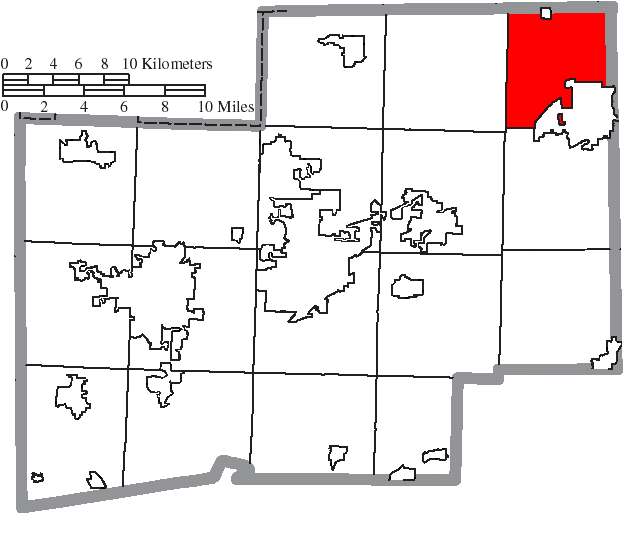
Photo: Ruhrfisch and Nyttend, CC BY-SA 3.0 · Wikimedia Commons
Local history sources: en.wikipedia.org · en.wikipedia.org · en.wikipedia.org · commons.wikimedia.org · archive.org
Historic places
1 place in Lexington Township, Stark County on the National Register of Historic Places. Press a pin or a name for its whole record.
-
Science Hill SchoolBuilding · Alliance · listed 1994
- Address
- 11810 Beeson St.
- Where
- Alliance, Stark County · ZIP 44601
- What it is
- Building
- Listed on the National Register
- 1994
- NRIS reference number
- 94000776
- Coordinates
- 40.92349, -81.17369
National Register file (NPS) ↗ Search Wikipedia ↗ Street map and directions ↗ On the Cracked Buckeye map
Source: National Park Service, National Register of Historic Places point file. The listing year is shown where NPS's certification date agrees with the listing's reference number. Listing recognizes significance; it does not restrict a private owner.
Water
Mostly private wells The water here
- Alliance City100% of residentsWalborn Reservoir + Deer Creek Reservoir + Mahoning River
- Spring Lakes Mobile Home Park0% of residentsGroundwater wells (2 wells)
Hospitals, fire stations and more
Inside Lexington Township, Stark County's boundary: 2 nursing homes, 2 fire and EMS stations, 1 high-hazard dam, 3 public schools, 1 museum, 1 public charging site, 2 shale and injection wells, 5 Toxics Release Inventory facilities and 9 spill cases. Press a pin or a name for its whole record and its source.
Nursing homes (2)
-
Altercare of Alliance Ctr for Rehab & Nc Inc3 of 5 stars · Alliance
- Address
- 11750 Klinger Avenue Ne, Alliance, OH 44601
- Certified beds
- 96
- Residents on an average day
- 68
- Medicare overall rating
- 3 of 5 stars
- Health inspections
- 3 of 5 stars
- Staffing
- 1 of 5 stars
- Quality measures
- 5 of 5 stars
- Penalties since 2023
- none
- Ownership
- For profit - Corporation
- Chain
- ALTERCARE
- Takes
- Medicare and Medicaid
- Phone
- (330) 823-8263
- Medicare ID
- 365402
Medicare Care Compare ↗ CMS nursing home data (source) ↗ Street map and directions ↗
-
Roselawn Gardens Nursing & Rehabilitation5 of 5 stars · Alliance
- Address
- 11999 Klinger Avenue Ne, Alliance, OH 44601
- Certified beds
- 44
- Residents on an average day
- 41
- Medicare overall rating
- 5 of 5 stars
- Health inspections
- 4 of 5 stars
- Staffing
- 2 of 5 stars
- Quality measures
- 5 of 5 stars
- Penalties since 2023
- none
- Ownership
- For profit - Corporation
- Chain
- HILLSTONE HEALTHCARE
- Takes
- Medicare and Medicaid
- Phone
- (330) 823-0618
- Medicare ID
- 366231
Medicare Care Compare ↗ CMS nursing home data (source) ↗ Street map and directions ↗
Source: CMS Care Compare nursing home provider and penalties files; Medicare star ratings run 1 to 5.
Fire and EMS stations (2)
-
Lexington Township Fire Department Station 1Alliance
- Address
- 14555 Gaskill Drive Northeast, Alliance, OH 44601
- Coordinates
- 40.94259, -81.11975
USGS National Map structures (source) ↗ Street map and directions ↗
-
Lexington Township Fire Department Station 2Alliance
- Address
- 11700 Rockhill Avenue Northeast, Alliance, OH 44601
- Coordinates
- 40.94110, -81.11430
USGS National Map structures (source) ↗ Street map and directions ↗
Source: USGS National Map structures (most Ohio records last updated 2019 to 2022), checked against the Columbus and Cleveland station lists. The department that answers a call is set by jurisdiction and mutual aid, not by distance.
High-hazard dams (1)
-
Dale Walborn Reservoir Dam PoorDeer Creek · condition: poor
- Hazard class
- High: a failure would probably cost a life
- Condition
- Poor (assessed 12/12/2022)
- River or stream
- Deer Creek
- Purpose
- Water Supply
- Type
- Earth
- Height
- 37 ft
- Storage
- 13,513 acre-feet
- Completed
- 1971
- Owner type
- Local Government
- County
- Stark County
- Nearest town (NID)
- Limaville
- Last inspection
- 11/17/2021
- Emergency action plan
- Yes
- NID ID
- OH00241
National Inventory of Dams record ↗ National Inventory of Dams (source) ↗ Street map and directions ↗
Source: U.S. Army Corps of Engineers National Inventory of Dams, August 2026. "High hazard" rates what a failure would cost downstream, not how likely one is; the condition is the state's assessment.
Public schools (3)
-
Lexington Elementary School3.5 of 5 stars · Alliance
- Address
- 12333 Atwater Ave NE, Alliance, OH 44601
- School district
- Marlington Local School District
- Kind (NCES)
- Regular School
- Students, 2023-24
- 319
- Teachers (full-time equivalent)
- 16
- Report card, 2025-26
- 3.5 of 5 stars
- Performance index
- 80%
- Ohio building IRN
- 020230
- NCES school ID
- 390498803730
NCES school record ↗ Ohio School Report Card ↗ Street map and directions ↗
-
Marlington High School4 of 5 stars · Alliance
- Address
- 10450 Moulin Ave NE, Alliance, OH 44601
- School district
- Marlington Local School District
- Kind (NCES)
- Regular School
- Students, 2023-24
- 707
- Teachers (full-time equivalent)
- 36.6
- Report card, 2025-26
- 4 of 5 stars
- Performance index
- 82.2%
- Four-year graduation rate
- 95.6%
- Ohio building IRN
- 022947
- NCES school ID
- 390498803732
NCES school record ↗ Ohio School Report Card ↗ Street map and directions ↗
-
Marlington Middle School4 of 5 stars · Alliance
- Address
- 10325 Moulin Ave NE, Alliance, OH 44601
- School district
- Marlington Local School District
- Kind (NCES)
- Regular School
- Students, 2023-24
- 394
- Teachers (full-time equivalent)
- 24.6
- Report card, 2025-26
- 4 of 5 stars
- Performance index
- 75.9%
- Ohio building IRN
- 061820
- NCES school ID
- 390498803733
NCES school record ↗ Ohio School Report Card ↗ Street map and directions ↗
Source: NCES EDGE public school locations 2024-25 and Common Core of Data 2023-24 (type, students, teachers); Ohio School Report Cards 2025-26 (Department of Education and Workforce), matched by name within the district.
Museums, historical societies, gardens and zoos (1)
-
Science Hill Historical SocietyHistorical society · Alliance
- What it is
- Historical society
- City
- Alliance
- Coordinates
- 40.93406, -81.17279
Search Wikipedia ↗ IMLS Museum Data Files (source) ↗ Street map and directions ↗
The museum list is IMLS's 2018 file; a museum may have closed or moved since.
Source: IMLS Museum Data Files, 2018.
Public EV charging (1)
-
Steel Equipment Specialists - Tesla Destination6 Level 2 · Alliance
- Address
- 1507 Beeson St NE, Alliance, OH 44601
- Ports
- 6 Level 2
- Plugs
- Tesla (NACS)
- Network
- Tesla Destination
- Phone
- 877-798-3752
Station Locator (NREL) ↗ Alternative Fuels Data Center (source) ↗ Street map and directions ↗
Source: NREL Alternative Fuels Data Center station list (May 2026), public and open stations, the posts at one address counted as one site.
Shale and injection wells (2)
-
Barber Unit {Swiw#17} 1 InjectionInjection well (Class II)
- What it is
- Injection well (Class II)
- Operator
- Ows Acquisition Co Llc
- County
- Stark County
- API well number
- 34151238770000
- Coordinates
- 40.97238, -81.09395
ODNR oil and gas wells (source) ↗ Street map and directions ↗
-
Patricia S. Barber Unit {Swiw#19} 2 InjectionInjection well (Class II)
- What it is
- Injection well (Class II)
- Operator
- Ows Acquisition Co Llc
- County
- Stark County
- API well number
- 34151243520000
- Coordinates
- 40.97236, -81.10355
ODNR oil and gas wells (source) ↗ Street map and directions ↗
Source: ODNR Division of Oil and Gas Resources well inventory (September 2026): drilled Utica, Marcellus and horizontal wells and Class II injection wells not plugged. Older vertical wells are on the full map.
Facilities reporting toxic releases (5)
-
Damon Industries IncToxics Release Inventory · Alliance
- Address
- 12435 Rockhill Ne, Alliance, OH 44601
- County
- Stark County County
- Status
- Reports to the Toxics Release Inventory (open)
- EPA program ID
- 44601DMNCH12435
- EPA registry ID
- 110000390210
EPA facility record ↗ EPA Facility Registry Service (source) ↗ Street map and directions ↗
-
GmiToxics Release Inventory · Alliance
- Address
- 12241 Rockhill Avenue Northeast, Alliance, OH 44601
- County
- Stark County
- Status
- Reports to the Toxics Release Inventory (active)
- EPA program ID
- 44601XXXGM12241
- EPA registry ID
- 110000823529
EPA facility record ↗ EPA Facility Registry Service (source) ↗ Street map and directions ↗
-
Gnw Aluminum IncToxics Release Inventory · Alliance
- Address
- 1356 Harrisburg Rd, Alliance, OH 44601
- County
- Stark County
- Status
- Reports to the Toxics Release Inventory (active)
- EPA program ID
- 44601GNWLM1356H
- EPA registry ID
- 110006272522
EPA facility record ↗ EPA Facility Registry Service (source) ↗ Street map and directions ↗
-
Tpi Abrasives Llc (1576000070)Toxics Release Inventory · Alliance
- Address
- 16123 Armour St., Alliance, OH 44601
- County
- Stark County
- Status
- Reports to the Toxics Release Inventory (active)
- EPA program ID
- 44601SMRCN16123
- EPA registry ID
- 110000390247
EPA facility record ↗ EPA Facility Registry Service (source) ↗ Street map and directions ↗
-
Tri-Seal Llc (1576001602)Toxics Release Inventory · Alliance
- Address
- 16125 Armour Street Northeast, Alliance, OH 44601
- County
- Stark County
- Status
- Reports to the Toxics Release Inventory (active)
- EPA program ID
- 44601SNCPL16123
- EPA registry ID
- 110000390256
EPA facility record ↗ EPA Facility Registry Service (source) ↗ Street map and directions ↗
Source: EPA Facility Registry Service, Toxics Release Inventory reporters. Reporting a release is required of large users of listed chemicals; it is not by itself a violation.
Spills reported since 2021 (9)
-
Oil Petroleum Not Otherwise Specified (Nos) Reached water2025-10-15 · Lexington Twp
- Reported
- 2025-10-15
- What spilled
- Oil Petroleum Not Otherwise Specified (Nos)
- Reached a waterway
- 76 - Deer Creek
- Where
- Lexington Twp, Stark County
- Ohio EPA district office
- NEDO
- Ohio EPA case number
- 2510EPA0001711
Ohio EPA spill reports (source) ↗ Street map and directions ↗
-
Oil Hydraulic Fluid(S)2024-01-30 · Lexington Twp
- Reported
- 2024-01-30
- What spilled
- Oil Hydraulic Fluid(S)
- Largest amount reported
- 30 gallons
- Where
- Lexington Twp, Stark County
- Ohio EPA district office
- NEDO
- Ohio EPA case number
- 2401EPA0000159
Ohio EPA spill reports (source) ↗ Street map and directions ↗
-
Oil Hydraulic Fluid(S)2023-12-11 · Lexington Twp
- Reported
- 2023-12-11
- What spilled
- Oil Hydraulic Fluid(S)
- Largest amount reported
- 40 gallons
- Where
- Lexington Twp, Stark County
- Ohio EPA district office
- NEDO
- Ohio EPA case number
- 2312EPA0002041
Ohio EPA spill reports (source) ↗ Street map and directions ↗
-
Other / All Other / Trade Name / Mixture / Solution Etc2023-04-08 · Limaville
- Reported
- 2023-04-08
- What spilled
- Other / All Other / Trade Name / Mixture / Solution Etc
- Where
- Limaville, Stark County
- Ohio EPA district office
- NEDO
- Ohio EPA case number
- 2304EPA0000537
Ohio EPA spill reports (source) ↗ Street map and directions ↗
-
Chemical(S) Unk Reached water2022-03-25 · Lexington Twp
- Reported
- 2022-03-25
- What spilled
- Chemical(S) Unk
- Largest amount reported
- 500 gallons
- Reached a waterway
- 76 - Beech Creek
- Where
- Lexington Twp, Stark County
- Ohio EPA district office
- NEDO
- Ohio EPA case number
- 2203EPA0000417
Ohio EPA spill reports (source) ↗ Street map and directions ↗
-
Material Unknown2021-11-10 · Lexington Twp
- Reported
- 2021-11-10
- What spilled
- Material Unknown
- Where
- Lexington Twp, Stark County
- Ohio EPA district office
- NEDO
- Ohio EPA case number
- 2111EPA0001722
Ohio EPA spill reports (source) ↗ Street map and directions ↗
-
Aluminum Sulfate (Al2(So4)3)2021-07-02 · Lexington Twp
- Reported
- 2021-07-02
- What spilled
- Aluminum Sulfate (Al2(So4)3)
- Where
- Lexington Twp, Stark County
- Ohio EPA district office
- NEDO
- Ohio EPA case number
- 2107EPA0000985
Ohio EPA spill reports (source) ↗ Street map and directions ↗
-
Oil Transformer Non Pcb2026-06-14 · Lexington Twp
- Reported
- 2026-06-14
- What spilled
- Oil Transformer Non Pcb
- Largest amount reported
- 15 gallons
- Where
- Lexington Twp, Stark County
- Ohio EPA district office
- NEDO
- Ohio EPA case number
- 2606EPA0001061
Ohio EPA spill reports (source) ↗ Street map and directions ↗
-
Sheen Rainbow / Hydrocarbon Reached water2026-05-20 · Lexington Twp
- Reported
- 2026-05-20
- What spilled
- Sheen Rainbow / Hydrocarbon
- Reached a waterway
- 76 - Mahoning River
- Where
- Lexington Twp, Stark County
- Ohio EPA district office
- NEDO
- Ohio EPA case number
- 2605EPA0000854
Ohio EPA spill reports (source) ↗ Street map and directions ↗
Source: Ohio EPA emergency response spill reports, 2021 to September 2026, one point per case where Ohio EPA placed it. A report is what the caller or responder recorded; amounts are often blank or estimated.
Its ZIP codes
Each ZIP code that touches Lexington Township, Stark County, with the share of its residents who live here and the same headline figures as the ZIP page.
| ZIP | Share | Water | Radon | Home value | Schools | Flood |
|---|---|---|---|---|---|---|
| 44640 Lexington Township and Limaville | 100% | Mostly private wells | Too few radon tests | Median year built 1864 | Marlington Local · 4 stars overall | 19% of residents in the 1% floodplain |
| 44601 Alliance | 14% | Blended surface supply drawn from the Walborn Reservoir and Deer Creek Reservoir (both southeast of the city, part of the Muskingum Watershed Conservancy District system) with a supplemental Mahoning River intake | 3.0 pCi/L average radon | Median year built 1948 | Alliance City · 3 stars overall | 1.7% of residents in the 1% floodplain |
| 44201 Randolph Township and Atwater | 1% | Mostly private wells | 3.5 pCi/L average radon | Parcel list only | Waterloo Local · 3 stars overall | 0.1% of residents in the 1% floodplain |
Local government
Who holds office in Lexington Township, Stark County, how its elections and ballot issues came out, and the state auditor's record.
Who holds office
| Office | Name | Party | Term ends | Contact |
|---|---|---|---|---|
| Trustee | Jerry Edward Moffett | R | 2027-12-31 | 330-206-3685 11956 Snode St. NE Alliance 44601 |
| Trustee | Daniel J. Moore | R | 2029-12-31 | 330-495-6255 11961 Aebi Ave. NE Alliance 44601 |
| Trustee | Mike Pauli | R | 2029-12-31 | 330-428-0451 12435 Edison St. NE Alliance 44601 |
| Fiscal Officer | Jill McNeil | R | 2028-03-31 | 330-823-6830 13116 Snode St. NE Alliance 44601 |
Roster as of 2026-08-12: county board of elections.
Money issues on the ballot since 2015: 16 of 20 passed; of those asking for new or higher taxes, 1 of 3.
Ballot issues
| Date | Issue | For | Against | Result |
|---|---|---|---|---|
| 2025-11-04 | Issue: Lexington Township - Roads | 694 | 333 | Passed (67.58% for) |
| 2025-11-04 | Issue: Lexington Township - Police (2.9 mills) | 616 | 400 | Passed (60.63% for) |
| 2025-11-04 | Issue: Lexington Township - Police (1 mill) | 624 | 394 | Passed (61.3% for) |
| 2024-11-05 | Issue: Lexington Township | 1,614 | 841 | Passed (65.74% for) |
| 2024-03-19 | Issue: Lexington Township, Roads | 445 | 572 | Failed (43.76% for) |
| 2023-11-07 | Issue: Lexington Township (Roads) | 1,108 | 548 | Passed (66.91% for) |
| 2023-11-07 | Issue: Lexington Township (Police) | 1,034 | 592 | Passed (63.59% for) |
| 2023-11-07 | Issue: Lexington Township (Roads, Additional) | 753 | 883 | Failed (46.03% for) |
| 2022-11-08 | Issue: Lexington Township | 1,188 | 626 | Passed (65.49% for) |
| 2020-11-03 | Issue: Lexington Twp. Fire District, Renewal | 1,816 | 712 | Passed (71.84% for) |
| 2020-11-03 | Issue: Lexington Twp. Police Levy, Renewal, 2.9 mills | 1,511 | 987 | Passed (60.49% for) |
| 2020-11-03 | Issue: Lexington Twp. Police Levy, Renewal, 1 mill | 1,552 | 935 | Passed (62.4% for) |
| 2020-11-03 | Issue: Lexington Township, Road Levy | 1,732 | 787 | Passed (68.76% for) |
| 2018-11-06 | Issue: Lexington Township Fire District | 1,494 | 562 | Passed (72.67% for) |
| 2018-11-06 | Issue: Lexington Township, Police | 1,360 | 693 | Passed (66.24% for) |
| 2018-05-08 | Issue: Lexington Township, Current Expenses | 444 | 441 | Passed (50.17% for) |
| 2017-11-07 | Issue: Lexington Twp Current Expenses | 585 | 586 | Failed (49.96% for) |
| 2016-11-08 | Issue: Lexington Township Fire District | 1,680 | 628 | Passed (72.79% for) |
| 2016-03-15 | Issue: Lexington Township Police Levy | 817 | 639 | Passed (56.11% for) |
| 2015-11-03 | Issue: Lexington Twp Roads | 986 | 563 | Passed (63.65% for) |
| 2015-11-03 | Issue: Lexington Twp Police, replacement | 906 | 633 | Passed (58.87% for) |
| 2015-11-03 | Issue: Lexington Twp Police, additional | 694 | 849 | Failed (44.98% for) |
Elections for office
| Date | Office | Candidates and votes |
|---|---|---|
| 2025-11-04 | Trustee | Victoria Brock 172, 9.3%; Tammera Davis 239, 12.93%; Daniel J. Moore 474, 25.64%; Mike Pauli 720, 38.94%; Bart Stuchell 244, 13.2% |
| 2023-11-07 | Trustee | Guy E. Aumend 556, 38.4%; Jerry Edward Moffett 892, 61.6% |
| 2023-11-07 | Fiscal Officer | Jill McNeil 1,283, 100.0% |
| 2021-11-02 | Trustee (number of seats not on file, so winners are not marked) | Guy E. Aumend 256, 14.49%; Daniel Moore 658, 37.24%; Mike Pauli 853, 48.27% |
| 2019-11-05 | Trustee | James Mathews 974, 100.0% |
| 2019-11-05 | Fiscal Officer | Jill McNeil 888, 100.0% |
| 2017-11-07 | Trustee | Daniel J. Moore 621, 39.63%; Michael K. Pauli 946, 60.37% |
| 2015-11-03 | Trustee | James Mathews 1,213, 100.0% |
| 2015-11-03 | Fiscal Officer | Jill M. McNeil 1,103, 100.0% |
Winners in bold. Results from the county board of elections' official canvass unless marked.
Auditor of State record
- No fiscal caution, watch or emergency on the Auditor of State's lists.
- Financial Audit, 2023 to 2024, released 2026-06-02
The county
Stark County: 34 ZIP codes, 36 cities, villages and townships, 374,115 people.
Nearby places
Quick answers
What county is Lexington Township, Ohio in?
Lexington Township, Stark County is a township in Stark County, Ohio, with 4,925 residents.
When was Lexington Township, Ohio founded?
Lexington Township, Stark County was settled 1805-06; laid out 1807 (town of Lexington). Founders on record: Quaker families including Amos Holloway, Zaccheus Stanton, Nathan Gaskill, John Grant, David Berry and Jesse Feltz. Source
What ZIP code is Lexington Township, Ohio?
Lexington Township, Stark County is served by ZIP codes 44640 and 44601; 44640 holds the largest share of its residents.
Where does Lexington Township, Ohio get its water?
The main water source for Lexington Township, Stark County (Alliance City): Mostly private wells.
Cite this page
Cite this page as:
Cracked Buckeye, "Lexington Township, Stark County", https://crackedbuckeye.com/place/lexington-township-stark-county/, built 2026-10-31, accessed [date].
How to cite · Report a correction · Built 2026-10-31
