Local events in Lost Creek Township, Miami County
Nothing is posted for Lost Creek Township itself yet; here is what is on within 10 miles. All local events in Lost Creek Township, Miami County
Know a calendar we should watch? Send the link
Checked October 20; the events page is refreshed daily.
How Lost Creek Township, Miami County began
Lost Creek Township, in eastern Miami County, was formally organized in December 1818 as the county's thirteenth township, though settlers had been on the ground since 1802-1804. It takes its name, by local tradition, from a Shawnee hunter who followed the winding creek believing it, like himself, had lost its way. Its one village, Casstown, grew from three cabins laid out in 1832 as "Trimmensburgh" into a dry, church-going community of 375 people by 1880, by the county history's count; the township's Civil War record and an 1832 cholera scare are its best-told stories.
Settled 1802-1804, incorporated December 10, 1818 (township organized; boundaries fixed January 25, 1819), by Willis Northcutt and John Rogers, earliest settlers; formal organization by the Miami County Commissioners.
Where the name comes from
Local tradition, recorded in the 1880 county history, holds that a Shawnee hunter became lost while following the creek during a hunt and came to believe that, like himself, the stream itself was "lost" — a legend that gave both the waterway and the later township their name.
Before the town
The township's own name preserves a Shawnee-attributed origin story about the creek (see name_origin). The War of 1812 brought documented violence to the township: David Gerard and Henry Dilbone and his wife were killed by Shawnee raiders within the township's bounds, and General William Hull's troops passed through a blockhouse at Rogers' place en route to Detroit in 1812 (the 1880 county history dates the march to 1811). These are settler-recorded events from a period of active conflict along the frontier; no mound, earthwork, or Native village site specific to this township was found.
Nations recorded here: Shawnee.
Timeline
- — Willis Northcutt and John Rogers arrive as the township's earliest recorded settlers, well before formal organization.
- — General William Hull's troops pass through a blockhouse at Rogers' place on their way to Detroit at the outset of the War of 1812; the 1880 county history dates the march to 1811.
- — The Lost Creek Baptist Church, the township's oldest religious body, is organized at Jonathan Cavault's house with Samuel Deweese as its first minister.
- — Miami County Commissioners establish Lost Creek as the county's thirteenth township on December 10; its boundaries are fixed January 25, 1819.
- — The Lost Creek Baptist congregation builds its first meetinghouse, a hewn-log building thirty by thirty-six feet.
- — Rankin Westfall and Luke Daney lay out the village of Casstown, originally called Trimmensburgh, on land bought from James Frazee; the same year a cholera epidemic strikes the township.
- — A post office named Casstown begins operating, the name honoring U.S. Senator and presidential candidate Lewis Cass.
- — Casstown's Lutheran congregation, organized 1835-1840, replaces its stone church building with one of brick.
Stories
The dance that stopped when the cholera tune played
Cholera struck Lost Creek Township twice, in 1832 and again in 1836. The 1880 county history preserves one story from the first outbreak: neighbors had gathered at John Martin's house for an evening of dancing when a fiddler struck up what the gathering half-jokingly called a "cholera tune," and frightening noises from the barn sent the whole assembly scattering into the night. Not long after, the history notes flatly, "the cholera did come," and it claimed several who had been at that dance. The story sits in the record as the township's clearest piece of pioneer folk memory, the kind of half-superstitious anecdote 1880s county historians liked to preserve alongside land deeds and church rolls.
Trimmensburgh becomes Casstown, and stays dry
Casstown began in 1832 as three cabins on land Rankin Westfall and Luke Daney bought from James Frazee, and was first called Trimmensburgh for a Mr. Trimmens. It was renamed for Lewis Cass, the American general, territorial governor, and 1848 presidential candidate, and a post office under the Casstown name opened in 1846. By 1880 it had grown to 375 residents, three churches (Baptist, Lutheran, and Methodist Episcopal), and an Odd Fellows hall, and the county historian noted with evident approval that "not a drop of liquor is sold within the corporation" — a detail meant to signal the village's respectability to 1880s readers.
Two hundred soldiers, and none killed outright
During the Civil War, Lost Creek Township "replied more liberally to the calls of the President than" most rural townships of its size, according to the 1880 county history, sending more than two hundred men to the front. The same account states that the township lost not a single soldier killed outright in action, an unusual claim for a rural township of its size that the county historian offered as a point of local pride.
Photographs
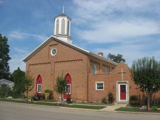
Photo: Nyttend, Wikimedia Commons, public domain · Wikimedia Commons
Local history sources: en.wikipedia.org · thetroyhistoricalsociety.org · en.wikipedia.org · en.wikipedia.org · en.wikipedia.org · commons.wikimedia.org
Water
Mostly private wells The water here
- Troy City67% of residentsGreat Miami Buried Valley Aquifer (wells)
- Fletcher Village25% of residentsGroundwater wells (2 wells)
- Christiansburg Village3% of residentsGroundwater wells (2 wells)
- Miami Co-camp Troy2% of residentsGreat Miami Buried Valley Aquifer (wells)
- NAWA1% of residentsGreat Miami Buried Valley Aquifer (wells)
- Grandview Heights Civic Association1% of residentsGroundwater wells (2 wells)
- Miami Co-n25a Extension0% of residentsGreat Miami Buried Valley Aquifer (wells)
Hospitals, fire stations and more
Inside Lost Creek Township, Miami County's boundary: 1 fire or EMS station, 3 public schools, 3 poor-rated bridges and 1 spill case. Press a pin or a name for its whole record and its source.
Fire and EMS stations (1)
-
Casstown Community Volunteer Fire CompanyCasstown
- Address
- 4210 East State Route 55, Casstown, OH 45312
- Coordinates
- 40.05412, -84.12480
USGS National Map structures (source) ↗ Street map and directions ↗
Source: USGS National Map structures (most Ohio records last updated 2019 to 2022), checked against the Columbus and Cleveland station lists. The department that answers a call is set by jurisdiction and mutual aid, not by distance.
Public schools (3)
-
Miami East Elementary4.5 of 5 stars · Casstown
- Address
- 4025 North State Route 589, Casstown, OH 45312
- School district
- Miami East Local School District
- Kind (NCES)
- Regular School
- Students, 2023-24
- 592
- Teachers (full-time equivalent)
- 31.43
- Report card, 2025-26
- 4.5 of 5 stars
- Performance index
- 90.3%
- Ohio building IRN
- 010207
- NCES school ID
- 390486203317
NCES school record ↗ Ohio School Report Card ↗ Street map and directions ↗
-
Miami East High School5 of 5 stars · Casstown
- Address
- 3925 N State Route 589, Casstown, OH 45312
- School district
- Miami East Local School District
- Kind (NCES)
- Regular School
- Students, 2023-24
- 478
- Teachers (full-time equivalent)
- 22.97
- Report card, 2025-26
- 5 of 5 stars
- Performance index
- 89.5%
- Four-year graduation rate
- 100%
- Ohio building IRN
- 024372
- NCES school ID
- 390486203320
NCES school record ↗ Ohio School Report Card ↗ Street map and directions ↗
-
Miami East Junior High School5 of 5 stars · Casstown
- Address
- 4025 N State Route 589, Casstown, OH 45312
- School district
- Miami East Local School District
- Kind (NCES)
- Regular School
- Students, 2023-24
- 333
- Teachers (full-time equivalent)
- 19.1
- Report card, 2025-26
- 5 of 5 stars
- Performance index
- 90.9%
- Ohio building IRN
- 024364
- NCES school ID
- 390486203319
NCES school record ↗ Ohio School Report Card ↗ Street map and directions ↗
Source: NCES EDGE public school locations 2024-25 and Common Core of Data 2023-24 (type, students, teachers); Ohio School Report Cards 2025-26 (Department of Education and Workforce), matched by name within the district.
Bridges rated poor (3)
-
Casstown-Sidney over Little Lost CreekPoor · built 1963
- Condition
- Poor: a deck, superstructure, substructure or culvert rated 4 or below on the 0 to 9 scale
- What it is
- Bridge
- Built
- 1963
- Length
- 19 ft
- Owner
- County
- Vehicles a day
- 797
- Coordinates
- 40.05667, -84.13500
National Bridge Inventory (source) ↗ Street map and directions ↗
-
Casstown-Sidney over Middle Branch Lost CreekPoor · built 1961
- Condition
- Poor: a deck, superstructure, substructure or culvert rated 4 or below on the 0 to 9 scale
- What it is
- Bridge
- Built
- 1961
- Length
- 24 ft
- Owner
- County
- Vehicles a day
- 797
- Coordinates
- 40.06769, -84.13396
National Bridge Inventory (source) ↗ Street map and directions ↗
-
Peterson over East Branch Lost CreekPoor · built 1960
- Condition
- Poor: a deck, superstructure, substructure or culvert rated 4 or below on the 0 to 9 scale
- What it is
- Bridge
- Built
- 1960
- Length
- 20 ft
- Owner
- County
- Vehicles a day
- 383
- Coordinates
- 40.10167, -84.12167
National Bridge Inventory (source) ↗ Street map and directions ↗
Source: FHWA National Bridge Inventory 2025. "Poor" means one major part rated 4 or below on the 0 to 9 scale; it calls for repair, not closing, unless the state posts or closes the bridge.
Spills reported since 2021 (1)
-
Other / All Other / Trade Name / Mixture / Solution Etc2021-05-22 · Lostcreek Twp
- Reported
- 2021-05-22
- What spilled
- Other / All Other / Trade Name / Mixture / Solution Etc
- Where
- Lostcreek Twp, Miami County
- Ohio EPA district office
- SWDO
- Ohio EPA case number
- 2105EPA0000719
Ohio EPA spill reports (source) ↗ Street map and directions ↗
Source: Ohio EPA emergency response spill reports, 2021 to September 2026, one point per case where Ohio EPA placed it. A report is what the caller or responder recorded; amounts are often blank or estimated.
Its ZIP codes
Each ZIP code that touches Lost Creek Township, Miami County, with the share of its residents who live here and the same headline figures as the ZIP page.
| ZIP | Share | Water | Radon | Home value | Schools | Flood |
|---|---|---|---|---|---|---|
| 45312 Lost Creek Township and Casstown | 61% | Mostly private wells | 8.7 pCi/L average radon | Median year built 1965 | Miami East Local · 5 stars overall | 1.9% of residents in the 1% floodplain |
| 45326 Brown Township and Fletcher | 13% | Mostly private wells | 6.0 pCi/L average radon | Median year built 1940 | Miami East Local · 5 stars overall | 2.8% of residents in the 1% floodplain |
| 45317 Brown Township and Conover | 8% | Mostly private wells | 2.5 pCi/L average radon | Median year built 1942 | Miami East Local · 5 stars overall | 0.0% of residents in the 1% floodplain |
| 45373 Troy | 1% | 10 production wells in the Great Miami buried-valley aquifer at Miami Shores Golf Course and Troy Community Park, north of the treatment plant | 5.0 pCi/L average radon | Median year built 1971 | Troy City · 4.5 stars overall | 6.7% of residents in the 1% floodplain |
Local government
Who holds office in Lost Creek Township, Miami County, how its elections and ballot issues came out, and the state auditor's record.
Money issues on the ballot since 2019: 1 of 1 passed.
Ballot issues
| Date | Issue | For | Against | Result |
|---|---|---|---|---|
| 2019-11-05 | Issue: Lostcreek Fire Levy (Renewal) | 178 | 41 | Passed (81.28% for) |
Elections for office
| Date | Office | Candidates and votes |
|---|---|---|
| 2021-11-02 | Township Trustee | Eric M. Carey 189, 41.36%; Samuel Buchman 163, 35.67%; Lauren D. Knoop 105, 22.98% |
| 2019-11-05 | Township Trustee | Darreil Davis 196, 100.0% |
Winners in bold. Results from the county board of elections' official canvass unless marked.
The county
Miami County: 12 ZIP codes, 24 cities, villages and townships, 106,010 people.
Nearby places
Quick answers
What county is Lost Creek Township, Ohio in?
Lost Creek Township, Miami County is a township in Miami County, Ohio, with 1,336 residents.
When was Lost Creek Township, Ohio founded?
Lost Creek Township, Miami County was settled 1802-1804; incorporated December 10, 1818 (township organized; boundaries fixed January 25, 1819). Founders on record: Willis Northcutt and John Rogers, earliest settlers; formal organization by the Miami County Commissioners. Source
How did Lost Creek Township, Ohio get its name?
Local tradition, recorded in the 1880 county history, holds that a Shawnee hunter became lost while following the creek during a hunt and came to believe that, like himself, the stream itself was "lost" — a legend that gave both the waterway and the later township their name. Source
What ZIP code is Lost Creek Township, Ohio?
Lost Creek Township, Miami County is served by ZIP codes 45312, 45326 and 45317; 45312 holds the largest share of its residents.
Where does Lost Creek Township, Ohio get its water?
The main water source for Lost Creek Township, Miami County (Troy City): Mostly private wells.
Cite this page
Cite this page as:
Cracked Buckeye, "Lost Creek Township, Miami County", https://crackedbuckeye.com/place/lost-creek-township-miami-county/, built 2026-10-31, accessed [date].
How to cite · Report a correction · Built 2026-10-31
