Local events in Lawrence Township, Tuscarawas County
Nothing is posted for Lawrence Township itself yet; here is what is on within 20 miles. All local events in Lawrence Township, Tuscarawas County
Know a calendar we should watch? Send the link
Checked October 20; the events page is refreshed daily.
Deep dives about Lawrence Township, Tuscarawas County
Long reads built from maps, newspapers and public records. All deep dives
How Lawrence Township, Tuscarawas County began
Lawrence Township is the northernmost township in Tuscarawas County, a 26.6-square-mile block of the Tuscarawas River valley that holds two of the county's most distinctive places: Fort Laurens, the only Revolutionary War-era fortification built within Ohio's present borders, and the village of Zoar, the communal settlement of German Separatist Pietists founded in 1817. The township's first American settlement, Lawrenceville, was laid out by Abraham Mosser in 1805 across the river from what became Bolivar, itself platted in 1830 and named for the South American revolutionary Simon Bolivar. The Ohio and Erie Canal, cut through the township in the late 1820s, tied both Bolivar and Zoar to wider commerce and, in Zoar's case, paid off the Separatists' land debt. Today the township holds the villages of Bolivar and Zoar, the unincorporated place of Wilkshire Hills between them, and two state historic sites — Fort Laurens and the Zoar Historic District — that are among the most visited and documented in the county.
Settled 1752 (Shingas Town, Delaware settlement, precise site uncertain); 1805 (Lawrenceville, by Abraham Mosser, opposite Bolivar), platted 1830 (Bolivar); 1817 (Zoar, as a communal village, not platted as a conventional town), by Abraham Mosser (Lawrenceville, 1805); unnamed proprietors (Bolivar, 1830); Joseph Bimeler and the Society of Separatists of Zoar (Zoar, 1817).
Where the name comes from
No source we consulted gives a documented origin for the township's own name 'Lawrence'; Ohio has several townships of that name (also in Lawrence, Stark, and Washington counties), and none of the sources we used tie this one to a specific person. Bolivar, the township's northern village, was named for Simon Bolivar, the South American independence leader, reflecting the wave of American sympathy for Latin American independence movements in the 1820s. Zoar took its name from the Book of Genesis: the small town Lot fled to when Sodom was destroyed, chosen by the Separatists as a name for the refuge they had built after fleeing religious persecution in Wurttemberg.
Before the town
The land that became Lawrence Township was Delaware (Lenape) country in the mid-18th century. In 1752 the Delaware leader Shingas — a war chief allied at times with the French and later a signatory of peace efforts with the British — established a settlement remembered as Shingas Town at or near the site later occupied by Fort Laurens on the Tuscarawas River; the precise location and duration of Shingas Town are not detailed in the general sources consulted here, and it predates and is distinct from the Moravian Delaware mission towns (Schoenbrunn, Gnadenhutten) in the townships to the south. The township's one specific, well-documented Native military engagement is the siege of Fort Laurens: on February 22, 1779, a force of roughly 180 Mingo (Seneca-Cayuga) and Wyandot warriors, together with British regulars under Captain Henry Bird, attacked the fort's garrison, killing and scalping 17 soldiers and taking two prisoner in the fort's bloodiest single action of the war; the siege that followed lasted into the spring, starving the garrison down to eating boiled rawhide before it was lifted. Aside from Shingas Town and the Fort Laurens siege, no other site-specific Native villages, trails, mounds, or burial sites within Lawrence Township are documented in the sources consulted.
Nations recorded here: Lenape (Delaware), Mingo (Seneca-Cayuga), Wyandot.
- Shingas Town (village) — at or near the later site of Fort Laurens on the Tuscarawas River, present Bolivar, 1752 (en.wikipedia.org)
- Fort Laurens siege (battle) — Fort Laurens, west bank of the Tuscarawas River near present Bolivar, February 22 - late March/early April 1779 (en.wikipedia.org)
Timeline
- — The Delaware leader Shingas establishes Shingas Town on the Tuscarawas River at or near the future site of Fort Laurens.
- — Brigadier General Lachlan McIntosh leads a force of about 1,200 Continental and militia troops to build Fort Laurens on the Tuscarawas River, completing it that fall; it is named for Henry Laurens, president of the Continental Congress, and garrisoned by Colonel John Gibson with 19 officers and 152 men of the 13th Virginia Regiment when McIntosh withdraws to Pittsburgh for lack of supplies.
- — On February 22, roughly 180 Mingo and Wyandot warriors and British regulars under Captain Henry Bird attack near Fort Laurens, killing and scalping 17 soldiers and taking two prisoner, then besiege the fort for about a month before it is relieved; the garrison, reduced to eating boiled rawhide, is ordered abandoned that August by Colonel Daniel Brodhead.
- — Abraham Mosser founds Lawrenceville opposite the future site of Bolivar on the Tuscarawas River, the township's first American settlement.
- — German Separatist Pietists led by Joseph Bimeler, having fled religious persecution in Wurttemberg, buy roughly 5,500 acres on the Tuscarawas River and found the communal village of Zoar.
- — The Zoar Separatists dig their section of the Ohio and Erie Canal by hand under contract with the state, earning about $21,000 that lets them pay off their land debt ahead of schedule.
- — Bolivar is platted along the Ohio and Erie Canal on the Tuscarawas River and named for the South American independence leader Simon Bolivar.
- — Zoar's founding leader Joseph Bimeler dies, beginning the Society's slow decline.
- — The Society of Separatists of Zoar votes to dissolve and divides its communal property, worth roughly $1 million at its peak of more than 10,000 acres, among the remaining members.
- — The Zoar Historic District is listed on the National Register of Historic Places.
- — Fort Laurens is added to the National Register of Historic Places on November 10.
- — Archaeological excavation at the Fort Laurens site uncovers the fort's outline and an associated cemetery.
- — The remains of soldiers killed in the February 1779 attack near Fort Laurens are recovered and reinterred beneath the site's Tomb of the Unknown Patriot of the American Revolution.
- — The Zoar Historic District is redesignated a National Historic Landmark District.
Stories
The siege of Fort Laurens
Fort Laurens went up in the fall of 1778 on the west bank of the Tuscarawas River, the farthest-forward American post on the Ohio frontier and, as it turned out, the only fort the Continental Army ever built within what are now Ohio's borders. General Lachlan McIntosh had marched roughly 1,200 men out to build it as a stepping stone toward an attack on British-held Detroit, then pulled most of them back to Pittsburgh when supplies ran short, leaving Colonel John Gibson and about 170 men of the 13th Virginia Regiment to hold it through the winter. On February 22, 1779, a force of about 180 Mingo and Wyandot warriors together with British regulars under Captain Henry Bird struck near the fort, killing and scalping 17 soldiers and capturing two more — the worst single loss the garrison suffered. What followed was not a quick assault but a monthlong siege that starved the men inside; by the accounts that survive, they were reduced to boiling strips of old dried hides for food before the siege broke. The Continental Army judged the outpost not worth the cost of supplying it and ordered it abandoned that August. Part of the fort was later demolished when the Ohio and Erie Canal was built, but the outline of the fort was traced again by archaeologists in 1972-73, and in the 1980s the remains of soldiers killed in that February attack were found and reburied under a monument the site now calls the Tomb of the Unknown Patriot of the American Revolution.
Zoar digs its own canal
When the Society of Separatists of Zoar settled their 5,500 acres on the Tuscarawas River in 1817, they were a small, poor, and unpopular group of German dissenters. Ten years later the state of Ohio needed their stretch of riverbank for the Ohio and Erie Canal and gave them a choice: let outside contractors dig it, or take the contract themselves. The Separatists dug it, working their own land under Joseph Bimeler's direction through the second half of the 1820s, and came out the other side with about $21,000 in wages — enough to pay off the debt on their land years ahead of schedule. The canal that might have simply cut through their village instead became the thing that saved it, and by the 1850s, with Bimeler still at the helm, the Society owned more than 10,000 acres worth close to a million dollars. It did not survive him: he died in 1853, and by 1898 the remaining members voted to dissolve the common ownership and split the property among themselves. The village they built, preserved rather than plowed under by that late-19th-century breakup, is a National Historic Landmark District today.
Photographs
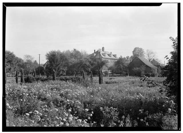
Photo: Carl Waite, Historic American Buildings Survey (Library of Congress), public domain · Wikimedia Commons
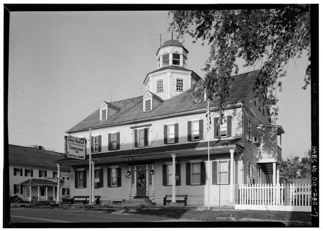
Photo: Historic American Buildings Survey (Library of Congress), documentation sponsored by Kent State University School of Architecture and Environmental Design, public domain · Wikimedia Commons
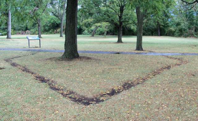
Photo: Wikimedia Commons user Roseohioresident, public domain · Wikimedia Commons
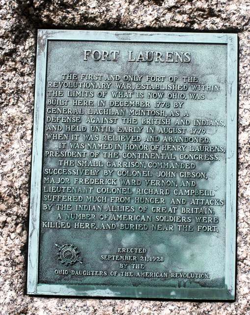
Photo: Wikimedia Commons user Roseohioresident, public domain · Wikimedia Commons
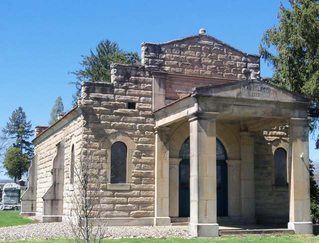
Photo: Wikimedia Commons user Roseohioresident, CC BY-SA 4.0 · Wikimedia Commons
Local history sources: en.wikipedia.org · en.wikipedia.org · ohiohistory.org · en.wikipedia.org · en.wikipedia.org · commons.wikimedia.org · commons.wikimedia.org · commons.wikimedia.org · commons.wikimedia.org · commons.wikimedia.org
Historic places
1 place in Lawrence Township, Tuscarawas County on the National Register of Historic Places. Press a pin or a name for its whole record.
-
Lebol, John, House, Smokehouse and SpringhouseBuilding · Bolivar · listed 1982
- Address
- Rt. 1
- Where
- Bolivar, Tuscarawas County · ZIP 44612
- What it is
- Building
- Listed on the National Register
- 1982
- NRIS reference number
- 82003660
- Coordinates
- 40.63867, -81.43408
National Register file (NPS) ↗ Search Wikipedia ↗ Street map and directions ↗ On the Cracked Buckeye map
Source: National Park Service, National Register of Historic Places point file. The listing year is shown where NPS's certification date agrees with the listing's reference number. Listing recognizes significance; it does not restrict a private owner.
Water
Groundwater wells (2 wells) The water here
- Tcmsd-wilkshire Hills64% of residentsGroundwater wells (2 wells)
- Bolivar Village22% of residentsGroundwater wells (2 wells)
- Dover City12% of residentsSugar Creek Basin sand-and-gravel aquifer (Dover wellfield)
- Strasburg Village3% of residentsGroundwater wells (2 wells)
Hospitals, fire stations and more
Inside Lawrence Township, Tuscarawas County's boundary: 1 nursing home, 1 museum, 3 Toxics Release Inventory facilities and 6 spill cases. Press a pin or a name for its whole record and its source.
Nursing homes (1)
-
Hennis Care Centre of Bolivar5 of 5 stars · Bolivar
- Address
- 300 Yant Street, Nw, Bolivar, OH 44612
- Certified beds
- 115
- Residents on an average day
- 106
- Medicare overall rating
- 5 of 5 stars
- Health inspections
- 4 of 5 stars
- Staffing
- 4 of 5 stars
- Quality measures
- 5 of 5 stars
- Penalties since 2023
- none
- Ownership
- For profit - Corporation
- Takes
- Medicare and Medicaid
- Phone
- (330) 874-9999
- Medicare ID
- 366200
- Map point
- the ZIP's center (the address did not geocode)
Medicare Care Compare ↗ CMS nursing home data (source) ↗ Street map and directions ↗
Source: CMS Care Compare nursing home provider and penalties files; Medicare star ratings run 1 to 5.
Museums, historical societies, gardens and zoos (1)
-
Fort Laurens MuseumMuseum · Bolivar
- What it is
- Museum
- City
- Bolivar
- Coordinates
- 40.63883, -81.45706
Search Wikipedia ↗ IMLS Museum Data Files (source) ↗ Street map and directions ↗
The museum list is IMLS's 2018 file; a museum may have closed or moved since.
Source: IMLS Museum Data Files, 2018.
Facilities reporting toxic releases (3)
-
Midwest Tank Services IncToxics Release Inventory · Bolivar
- Address
- 509 Water St, Bolivar, OH 44612
- County
- Tuscarawas County
- Status
- Reports to the Toxics Release Inventory (closed)
- EPA program ID
- 44612MDWSTWATER
- EPA registry ID
- 110000493537
EPA facility record ↗ EPA Facility Registry Service (source) ↗ Street map and directions ↗
-
Plant 1 StrasburgToxics Release Inventory · Strasburg
- Address
- 7666 Reed Rd. N.W., Strasburg, OH 44680
- County
- Tuscarawas County
- Status
- Reports to the Toxics Release Inventory (active)
- EPA program ID
- 44680THBLDPOBOX
- EPA registry ID
- 110000390835
EPA facility record ↗ EPA Facility Registry Service (source) ↗ Street map and directions ↗
-
Primary Packaging Inc (0679000276)Toxics Release Inventory · Bolivar
- Address
- 10810 Industrial Pkwy Nw, Bolivar, OH 44612
- County
- Tuscarawas County
- Status
- Reports to the Toxics Release Inventory
- EPA program ID
- 4461WPRMRY181IN
- EPA registry ID
- 110004713070
EPA facility record ↗ EPA Facility Registry Service (source) ↗ Street map and directions ↗
Source: EPA Facility Registry Service, Toxics Release Inventory reporters. Reporting a release is required of large users of listed chemicals; it is not by itself a violation.
Spills reported since 2021 (6)
-
Chemical(S) Unk2024-06-06 · Lawrence Twp
- Reported
- 2024-06-06
- What spilled
- Chemical(S) Unk
- Where
- Lawrence Twp, Tuscarawas County
- Ohio EPA district office
- SEDO
- Ohio EPA case number
- 2406EPA0000948
Ohio EPA spill reports (source) ↗ Street map and directions ↗
-
Fuel Diesel / Diesel Fuel (Vehicle On Or Off Road)2022-11-07 · Lawrence Twp
- Reported
- 2022-11-07
- What spilled
- Fuel Diesel / Diesel Fuel (Vehicle On Or Off Road)
- Largest amount reported
- 20 gallons
- Where
- Lawrence Twp, Tuscarawas County
- Ohio EPA district office
- SEDO
- Ohio EPA case number
- 2211EPA0001655
Ohio EPA spill reports (source) ↗ Street map and directions ↗
-
Sheen Rainbow / Hydrocarbon Reached water2021-10-19 · Lawrence Twp
- Reported
- 2021-10-19
- What spilled
- Sheen Rainbow / Hydrocarbon
- Reached a waterway
- 79 - Tuscarawas River
- Where
- Lawrence Twp, Tuscarawas County
- Ohio EPA district office
- SEDO
- Ohio EPA case number
- 2110EPA0001638
Ohio EPA spill reports (source) ↗ Street map and directions ↗
-
Orphan Container(S) Reached water2021-08-26 · Lawrence Twp
- Reported
- 2021-08-26
- What spilled
- Orphan Container(S)
- Reached a waterway
- 99 - Unnamed
- Where
- Lawrence Twp, Tuscarawas County
- Ohio EPA district office
- SEDO
- Ohio EPA case number
- 2108EPA0001337
Ohio EPA spill reports (source) ↗ Street map and directions ↗
-
Material Undetermined / Other2021-05-02 · Lawrence Twp
- Reported
- 2021-05-02
- What spilled
- Material Undetermined / Other
- Where
- Lawrence Twp, Tuscarawas County
- Ohio EPA district office
- SEDO
- Ohio EPA case number
- 2105EPA0000603
Ohio EPA spill reports (source) ↗ Street map and directions ↗
-
Natural Gas2026-03-22 · Lawrence Twp
- Reported
- 2026-03-22
- What spilled
- Natural Gas
- Where
- Lawrence Twp, Tuscarawas County
- Ohio EPA district office
- SEDO
- Ohio EPA case number
- 2603EPA0000455
Ohio EPA spill reports (source) ↗ Street map and directions ↗
Source: Ohio EPA emergency response spill reports, 2021 to September 2026, one point per case where Ohio EPA placed it. A report is what the caller or responder recorded; amounts are often blank or estimated.
Its ZIP codes
Each ZIP code that touches Lawrence Township, Tuscarawas County, with the share of its residents who live here and the same headline figures as the ZIP page.
| ZIP | Share | Water | Radon | Home value | Schools | Flood |
|---|---|---|---|---|---|---|
| 44612 Lawrence Township and Bolivar | 73% | Groundwater wells (2 wells) | 6.3 pCi/L average radon | Median year built 1979 | Tuscarawas Valley Local · 4 stars overall | 5.6% of residents in the 1% floodplain |
| 44697 Zoar | 13% | Mostly private wells | 5.7 pCi/L average radon | Median year built 1972 | Tuscarawas Valley Local · 4 stars overall | 25% of residents in the 1% floodplain |
| 44680 Strasburg | 3% | Groundwater wells (2 wells) | 9.8 pCi/L average radon | Median year built 1977 | Strasburg-Franklin Local · 3.5 stars overall | 1.6% of residents in the 1% floodplain |
| 44622 Dover | 3% | Sugar Creek Basin sand-and-gravel aquifer (Dover wellfield) | 6.0 pCi/L average radon | Median year built 1956 | Dover City · 3.5 stars overall | 2.9% of residents in the 1% floodplain |
Local government
Who holds office in Lawrence Township, Tuscarawas County, how its elections and ballot issues came out, and the state auditor's record.
Money issues on the ballot since 2020: 2 of 2 passed; of those asking for new or higher taxes, 1 of 1.
Ballot issues
| Date | Issue | For | Against | Result |
|---|---|---|---|---|
| 2025-05-06 | 7: 7 Lawrence Township Fire & EMS Levy (Renewal) Lawrence Twp | 260 | 126 | Passed (67.36% for) |
| 2020-11-03 | 13: 13 Proposed Tax Levy (Additional) Lawrence Township Lawrence Twp | 1,666 | 1,540 | Passed (51.97% for) |
Elections for office
| Date | Office | Candidates and votes |
|---|---|---|
| 2019-11-05 | Township Trustee | Patrick Eddy 116, 10.39%; Rick D. Erickson 49, 4.39%; Charlie Meiser 240, 21.51%; Justin T. Reidl 142, 12.72%; Matt Ritterbeck 569, 50.99% |
| 2019-11-05 | Township Fiscal Officer | John McClellan 908, 100.0% |
Winners in bold. Results from the county board of elections' official canvass unless marked.
Auditor of State record
- No fiscal caution, watch or emergency on the Auditor of State's lists.
- Agreed Upon Procedures, 2024 to 2025, released 2026-06-09
The county
Tuscarawas County: 17 ZIP codes, 40 cities, villages and townships, 92,903 people.
Nearby places
Quick answers
What county is Lawrence Township, Ohio in?
Lawrence Township, Tuscarawas County is a township in Tuscarawas County, Ohio, with 4,698 residents.
When was Lawrence Township, Ohio founded?
Lawrence Township, Tuscarawas County was settled 1752 (Shingas Town, Delaware settlement, precise site uncertain); 1805 (Lawrenceville, by Abraham Mosser, opposite Bolivar); laid out 1830 (Bolivar); 1817 (Zoar, as a communal village, not platted as a conventional town). Founders on record: Abraham Mosser (Lawrenceville, 1805); unnamed proprietors (Bolivar, 1830); Joseph Bimeler and the Society of Separatists of Zoar (Zoar, 1817). Source
What ZIP code is Lawrence Township, Ohio?
Lawrence Township, Tuscarawas County is served by ZIP codes 44612, 44697, 44680 and 44622; 44612 holds the largest share of its residents.
Where does Lawrence Township, Ohio get its water?
The main water source for Lawrence Township, Tuscarawas County (Tcmsd-wilkshire Hills): Groundwater wells (2 wells).
Cite this page
Cite this page as:
Cracked Buckeye, "Lawrence Township, Tuscarawas County", https://crackedbuckeye.com/place/lawrence-township-tuscarawas-county/, built 2026-10-31, accessed [date].
How to cite · Report a correction · Built 2026-10-31
