Local events in Zoar
Zoar itself has 2 events posted in the next 90 days; the others here are within 20 miles. All local events in Zoar
Checked October 20; the events page is refreshed daily.
Deep dives about Zoar
Long reads built from maps, newspapers and public records. All deep dives
How Zoar began
Zoar was founded in 1817 by about 150 German Separatists from Württemberg who had fled religious persecution by the Lutheran state church, and in 1819 they formally organized as the Society of Separatists of Zoar, a communal Christian society that held all property in common. Named for the Biblical village to which Lot fled in the Book of Genesis, the settlement paid off its land debt in the 1820s by digging its section of the Ohio and Erie Canal for the state, and under leader Joseph Bimeler grew into a prosperous, self-sufficient community that owned over 10,000 acres by the 1850s. The Society dissolved in 1898 and divided its property among the roughly 222 remaining members. The Zoar Historic District was listed on the National Register of Historic Places in 1969 and became a National Historic Landmark District in 2016; several buildings are preserved as a museum operated by the Ohio History Connection.
Settled 1817, by Society of Separatists of Zoar, German Separatist emigrants from Württemberg led by Joseph Bimeler.
Where the name comes from
Named after the Biblical town of Zoar, to which Lot and his family fled from the destruction of Sodom in the Book of Genesis.
Before the town
No source specific to the Zoar village site describing Native American villages, trails, mounds, or treaty history was found in the sources we checked. The Tuscarawas Valley more broadly was Delaware (Lenape) country in the 18th century, with Moravian mission towns (Schoenbrunn, Gnadenhutten, Salem, Goshen) elsewhere in the county; nothing in the sources consulted ties that history specifically to the Zoar tract.
Timeline
- — About 150 German Separatists from 36 villages in Württemberg, fleeing persecution by the Lutheran church, arrive in Ohio and settle land along the Tuscarawas River, naming it Zoar.
- — The settlers formally organize as the Society of Separatists of Zoar, pooling their property into a communal society governed by elected trustees.
- — Offered the choice by the State of Ohio, the Zoar Separatists spend several years digging the Ohio and Erie Canal through their own land for pay, earning about $21,000 that lets the Society pay off its land loans on time with money to spare.
- — The Society reaches its greatest prosperity, owning more than 10,000 acres of land and worth an estimated $1 million.
- — Society leader Joseph Bimeler dies, after which the community's cohesion gradually declines.
- — The remaining roughly 222 members of the Society of Separatists of Zoar vote to dissolve the communal society and divide its property, valued around $3.5 million, among themselves.
- — The Zoar Historic District is listed on the National Register of Historic Places.
- — The Zoar Historic District is designated a National Historic Landmark District.
Stories
A canal debt paid in ditch-digging
When the Separatists arrived in 1817 they had bought 5,500 acres of Tuscarawas Valley land sight unseen and owed a debt they had no easy way to repay. In the mid-1820s the State of Ohio was routing the Ohio and Erie Canal directly through their land and needed labor to dig it. The Zoarites took the job themselves, spending several years in the 1820s digging the canal, and the state paid them roughly $21,000, enough to clear their land debt outright with money left over. The episode turned a struggling religious refugee colony into a solvent, self-sufficient community and set it on the path to the prosperity it enjoyed at mid-century.
Common property, common table
In 1819, the Zoar Separatists formally organized as the Society of Separatists of Zoar: every member turned over personal property to the community, and in return the Society provided housing, food and work assignments for life. Farms, shops and mills were run by trustees elected by the membership rather than by individual owners. Under the leadership of Joseph Bimeler, a former pipemaker and teacher from Ulm, the arrangement held together for nearly eighty years and, at its 1850s peak, controlled over 10,000 acres and roughly a million dollars in assets. It ended in 1898 when the remaining members, no longer bound by the religious conviction that had founded it, voted to dissolve the Society and split the property among themselves.
Photographs
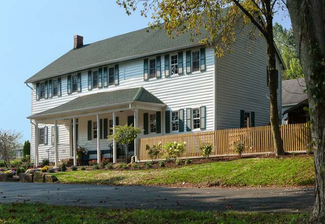
Photo: Wikimedia Commons contributor, CC BY-SA 3.0 · Wikimedia Commons
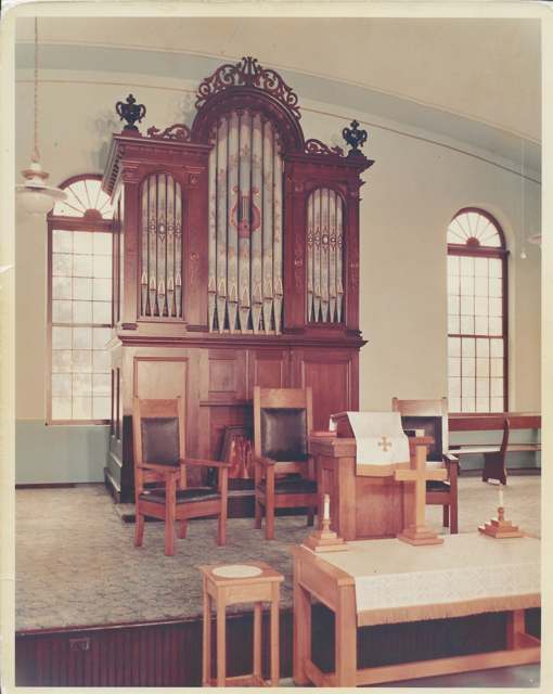
Photo: Wikimedia Commons contributor, CC BY-SA 4.0 · Wikimedia Commons
Local history sources: en.wikipedia.org · ohiohistory.org · savingplaces.org · commons.wikimedia.org · en.wikipedia.org
Water
Mostly private wells The water here
- Tcmsd-wilkshire Hills100% of residentsGroundwater wells (2 wells)
Hospitals, fire stations and more
Inside Zoar's boundary: 1 fire or EMS station and 1 museum. Press a pin or a name for its whole record and its source.
Fire and EMS stations (1)
-
Zoar Volunteer Fire DepartmentZoar
- Address
- 190 5th Street, Zoar, OH 44697
- Coordinates
- 40.61519, -81.42126
USGS National Map structures (source) ↗ Street map and directions ↗
Source: USGS National Map structures (most Ohio records last updated 2019 to 2022), checked against the Columbus and Cleveland station lists. The department that answers a call is set by jurisdiction and mutual aid, not by distance.
Museums, historical societies, gardens and zoos (1)
-
Zoar Village State MemorialMuseum · Zoar
- What it is
- Museum
- City
- Zoar
- Coordinates
- 40.61168, -81.42192
Search Wikipedia ↗ IMLS Museum Data Files (source) ↗ Street map and directions ↗
The museum list is IMLS's 2018 file; a museum may have closed or moved since.
Source: IMLS Museum Data Files, 2018.
Its ZIP codes
Each ZIP code that touches Zoar, with the share of its residents who live here and the same headline figures as the ZIP page.
| ZIP | Share | Water | Radon | Home value | Schools | Flood |
|---|---|---|---|---|---|---|
| 44697 Zoar | 62% | Mostly private wells | 5.7 pCi/L average radon | Median year built 1972 | Tuscarawas Valley Local · 4 stars overall | 25% of residents in the 1% floodplain |
Local government
Who holds office in Zoar, how its elections and ballot issues came out, and the state auditor's record.
Money issues on the ballot since 2020: 2 of 2 passed.
Ballot issues
| Date | Issue | For | Against | Result |
|---|---|---|---|---|
| 2020-11-03 | 3: 3 Proposed Tax Levy (Renewal) Village of Zoar Zoar Vlg | 86 | 34 | Passed (71.67% for) |
| 2020-11-03 | 4: 4 Proposed Tax Levy (Renewal) Village of Zoar Zoar Vlg | 80 | 38 | Passed (67.8% for) |
Elections for office
| Date | Office | Candidates and votes |
|---|---|---|
| 2019-11-05 | Member of Council | Hans Fischer 46, 33.82%; Thomas Klingaman 53, 38.97%; Paul R. Worley 37, 27.21% |
| 2019-11-05 | Mayor | Scott C. Gordon 50, 53.76%; Write-In: Judy Meiser 43, 46.24% |
Winners in bold. Results from the county board of elections' official canvass unless marked.
Auditor of State record
- No fiscal caution, watch or emergency on the Auditor of State's lists.
- Basic Audit, 2023 to 2024, released 2025-05-15
The county
Tuscarawas County: 17 ZIP codes, 40 cities, villages and townships, 92,903 people.
Nearby places
Rain and snow
How much has actually fallen on Zoar, day by day, from 1893 to now. Daily totals, not averages.
- rain, last 30 days
- 1.01 in
- 2026-09-30 to 2026-10-29
- rain so far in 2026
- 34.3 in
- about normal for the date
- snow so far in 2026
- 25.6 in
- a normal year brings 26.5 in
- a normal year
- 41.4 in
- average of 30 years, 1991-2020
| Month | Rain (in) | Snow (in) | Days counted |
|---|---|---|---|
| October 2026 | 1.01 | — | 29 |
| September 2026 | 3.77 | — | 30 |
| August 2026 | 5.68 | — | 31 |
| July 2026 | 2.83 | — | 31 |
| June 2026 | 2.60 | — | 30 |
| May 2026 | 5.29 | — | 31 |
| April 2026 | 4.99 | 0.0 | 30 |
| March 2026 | 5.13 | 2.0 | 31 |
| February 2026 | 1.12 | 3.8 | 28 |
| January 2026 | 1.86 | 19.8 | 31 |
| December 2025 | 2.29 | 11.1 | 31 |
| November 2025 | 1.90 | 0.3 | 30 |
| Wettest year | 2011 — 56.6 in |
|---|---|
| Driest year | 1963 — 26.8 in |
| Snowiest year | 1910 — 74.0 in |
| Wettest day on record | 5 July 1969 — 5.26 in |
| Heaviest snowfall in a day | 4 April 1987 — 13.59 in |
| Deepest snow on the ground | 21 April 1901 — 19.70 in |
Estimated, not measured. No rain gauge has ever stood inside Zoar, so every figure here is worked out from the gauges around it - the nearest ones weighted most. Treat them as close estimates rather than readings.
48,618 days of records, 1893-01-01 to 2026-10-29. Source: NOAA NCEI GHCN-Daily, 3,240 gauges in and around Ohio. A day is "gauged" when a gauge standing inside the boundary reported it, and the value is the mean of those gauges. Otherwise it is interpolated by inverse distance from every gauge reporting within 50 miles. Nothing is carried forward, back-filled or smoothed. Against NOAA nClimDiv county monthly precipitation over 136,848 complete county-months (checked 2026-10-31): correlation 0.9515, median absolute difference 0.217 in a month. Built 2026-10-31 from the Cracked Buckeye precipitation archive. Snow is the softer number — snowfall is measured by hand with a ruler, no agency publishes a gridded county snowfall series, and blowing snow defeats every observer.
Quick answers
What county is Zoar, Ohio in?
Zoar is a village in Tuscarawas County, Ohio, with 172 residents.
When was Zoar, Ohio founded?
Zoar was settled 1817. Founders on record: Society of Separatists of Zoar, German Separatist emigrants from Württemberg led by Joseph Bimeler. Source
How did Zoar, Ohio get its name?
Named after the Biblical town of Zoar, to which Lot and his family fled from the destruction of Sodom in the Book of Genesis. Source
What ZIP code is Zoar, Ohio?
Most of Zoar is in ZIP code 44697.
Where does Zoar, Ohio get its water?
The main water source for Zoar (Tcmsd-wilkshire Hills): Mostly private wells.
Cite this page
Cite this page as:
Cracked Buckeye, "Zoar, Tuscarawas County", https://crackedbuckeye.com/place/zoar/, built 2026-10-31, accessed [date].
How to cite · Report a correction · Built 2026-10-31
