Local events in Bolivar
Bolivar itself has 1 event posted in the next 90 days; the others here are within 10 miles. All local events in Bolivar
Checked October 20; the events page is refreshed daily.
Lakes near Bolivar
The history under the water: the valley before, the dam, the stories. All Ohio lakes
Deep dives about Bolivar
Long reads built from maps, newspapers and public records. All deep dives
How Bolivar began
Bolivar sits at the northern tip of Tuscarawas County on the Tuscarawas River, on ground that was a Delaware (Lenape) village called Shingas Town in the 1750s and then, in 1778, the site of Fort Laurens, the only fort the American army built during the Revolutionary War within present-day Ohio. The village itself was platted in 1830 as canal-boom development following the Ohio and Erie Canal and was named for the South American independence leader Simon Bolivar. It grew through the nineteenth century on canal and later rail traffic, peaking near 1,000 to 1,100 residents in the twentieth century, and today calls itself the "Gateway to Tuscarawas County." Fort Laurens' site is preserved as a state memorial and museum.
Platted 1830, by platted amid growth from the Ohio and Erie Canal; named for Simon Bolivar.
Where the name comes from
The village was named after Simon Bolivar, the South American independence leader, reflecting a wave of early-19th-century American place names honoring him.
Before the town
The ground at Bolivar was a Delaware (Lenape) settlement before Euro-American settlement: Shingas, a Lenape leader, established Shingas Town in the general vicinity around 1752. Twenty-six years later, in the fall of 1778, the Continental Army built Fort Laurens on the Tuscarawas River at essentially the same spot, in part to project American power toward Wyandot towns further west and, eventually, British-held Detroit. The fort's 1779 siege was carried out by an allied force of roughly 180 Mingo and Wyandot warriors together with British regulars and the Loyalist interpreter Simon Girty; seventeen of the fort's garrison were killed and scalped in the opening assault and two were taken prisoner. No mound, earthwork, or treaty line specific to the village site is documented in the sources checked beyond Shingas Town and the fort. The broader county record includes the Adena and Hopewell mound-building periods and the historic nations' presence and removal.
Nations recorded here: Lenape (Delaware), Mingo (Seneca-Cayuga), Wyandot.
- Shingas Town (village) — vicinity of present-day Bolivar, c. 1752 (en.wikipedia.org)
- Fort Laurens (site of the 1779 siege) (battle) — on the Tuscarawas River at Bolivar, 1778-1779 (en.wikipedia.org)
Timeline
- — Shingas, a Delaware (Lenape) leader, establishes Shingas Town in the vicinity of present-day Bolivar.
- — Brigadier General Lachlan McIntosh leads about 1,200 regulars and militia from Pittsburgh and builds Fort Laurens on the Tuscarawas River, naming it for Continental Congress president Henry Laurens; he leaves Colonel John Gibson with about 150 men of the 13th Virginia Regiment to garrison it.
- — On February 22, Simon Girty leads roughly 180 Mingo and Wyandot warriors with British regulars in a siege of Fort Laurens; 17 of the garrison are killed and scalped and two taken prisoner in the opening assault, and the siege continues for about four weeks before Captain Henry Bird withdraws.
- — Colonel Daniel Brodhead declares Fort Laurens untenable and it is abandoned in August.
- — Bolivar is platted, its growth tied to development along the newly built Ohio and Erie Canal.
- — Bolivar's population is recorded at 309.
- — Archaeologists recover the remains of soldiers killed in the February 1779 assault on Fort Laurens; one is reburied with full military honors at the site's Tomb of the Unknown Patriot.
- — The E.D. Fisher House in Bolivar is listed on the National Register of Historic Places.
Stories
The only Revolutionary War fort in Ohio
In the fall of 1778, General Lachlan McIntosh marched about 1,200 Continental soldiers and militia out of Pittsburgh with orders to strike at Wyandot towns and, if possible, push on toward British-held Fort Detroit. Supplies ran short before they got far, and McIntosh turned back, but not before his men raised a four-sided stockade with a blockhouse on the Tuscarawas River, naming it Fort Laurens for Continental Congress president Henry Laurens. He left Colonel John Gibson and about 150 Virginia regulars to hold it through the winter. On February 22, 1779, the British agent Simon Girty led some 180 Mingo and Wyandot warriors and a handful of British soldiers in a surprise assault; seventeen of the garrison were killed and scalped in the opening attack and two more taken captive. The siege dragged on for weeks; the trapped soldiers ran out of food, and by the end were boiling and eating their own moccasins to survive. The British force finally withdrew before relief arrived, but by August the fort's isolated position was judged untenable and it was abandoned. Today the Ohio History Connection preserves the site, and a museum run by the Zoar Community Association displays artifacts recovered in 1970s digs; soldiers found in a 1986 excavation were reburied with military honors at the site's Tomb of the Unknown Patriot.
Photographs
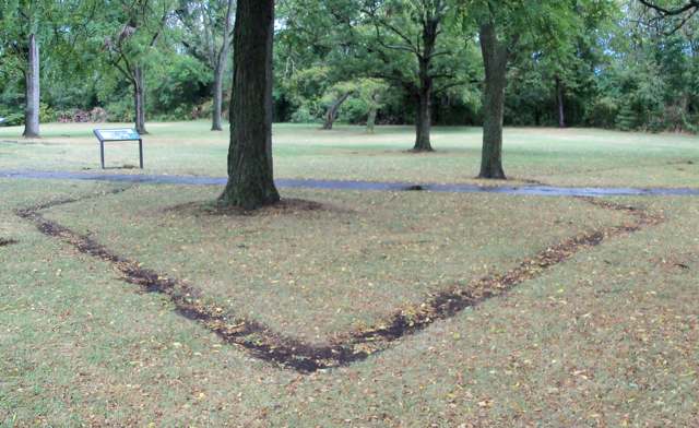
Photo: Roseohioresident, public domain · Wikimedia Commons
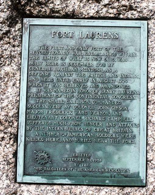
Photo: Roseohioresident, public domain · Wikimedia Commons
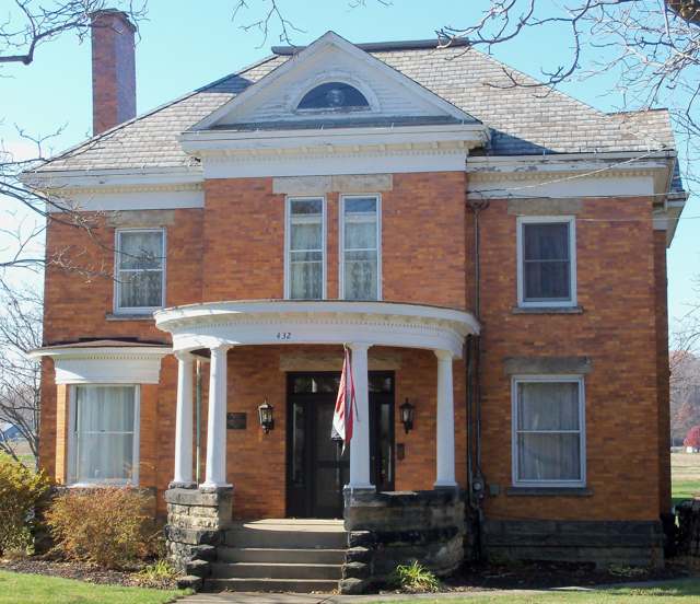
Photo: Roseohioresident, public domain · Wikimedia Commons
Photo: Roseohioresident, CC BY-SA 4.0 · Wikimedia Commons
Local history sources: en.wikipedia.org · en.wikipedia.org · en.wikipedia.org · commons.wikimedia.org · commons.wikimedia.org · commons.wikimedia.org · commons.wikimedia.org
Historic places
1 place in Bolivar on the National Register of Historic Places. Press a pin or a name for its whole record.
-
Fisher, E.D., HouseBuilding · Bolivar · listed 1999
- Address
- 432 S. Park Ave.
- Where
- Bolivar, Tuscarawas County · ZIP 44612
- What it is
- Building
- Listed on the National Register
- 1999
- NRIS reference number
- 99001194
- Coordinates
- 40.64580, -81.45435
National Register file (NPS) ↗ Search Wikipedia ↗ Street map and directions ↗ On the Cracked Buckeye map
Source: National Park Service, National Register of Historic Places point file. The listing year is shown where NPS's certification date agrees with the listing's reference number. Listing recognizes significance; it does not restrict a private owner.
Water
Groundwater wells (2 wells) The water here
- Tcmsd-wilkshire Hills74% of residentsGroundwater wells (2 wells)
- Bolivar Village26% of residentsGroundwater wells (2 wells)
Hospitals, fire stations and more
Inside Bolivar's boundary: 1 fire or EMS station, 1 library and 1 police station. Press a pin or a name for its whole record and its source.
Fire and EMS stations (1)
-
Bolivar Volunteer Fire DepartmentBolivar
- Address
- 456 Water Street, Bolivar, OH 44612
- Coordinates
- 40.65010, -81.45943
USGS National Map structures (source) ↗ Street map and directions ↗
Source: USGS National Map structures (most Ohio records last updated 2019 to 2022), checked against the Columbus and Cleveland station lists. The department that answers a call is set by jurisdiction and mutual aid, not by distance.
Public libraries (1)
-
Roy Parks Memorial BranchBranch · Bolivar
- Address
- 455 W Water St, Bolivar, OH 44612
- What it is
- Branch
- Library system
- Tuscarawas County Public Library
- Open
- 2,028 hours a year, 52 weeks
- Building
- 4,063 sq ft
- System's visits, FY2024
- 171,184
- System's loans, FY2024
- 751,497
- People the system serves
- 55,515
- Phone
- (330) 874-2720
IMLS Public Libraries Survey (source) ↗ Street map and directions ↗
Source: IMLS Public Libraries Survey FY2024 (outlets and their systems). Any Ohio resident can get a free card at any Ohio public library.
Police stations (1)
-
Bolivar Police DepartmentBolivar
- Address
- 117 Canal Street, Bolivar, OH 44612
- Coordinates
- 40.65001, -81.45082
USGS National Map structures (source) ↗ Street map and directions ↗
Source: USGS National Map structures, police stations, corrected and completed by hand (September 2026). The department that answers a call is set by jurisdiction, not by distance.
Its ZIP codes
Each ZIP code that touches Bolivar, with the share of its residents who live here and the same headline figures as the ZIP page.
| ZIP | Share | Water | Radon | Home value | Schools | Flood |
|---|---|---|---|---|---|---|
| 44612 Lawrence Township and Bolivar | 18% | Groundwater wells (2 wells) | 6.3 pCi/L average radon | Median year built 1979 | Tuscarawas Valley Local · 4 stars overall | 5.6% of residents in the 1% floodplain |
Local government
Who holds office in Bolivar, how its elections and ballot issues came out, and the state auditor's record.
Money issues on the ballot since 2019: 1 of 1 passed.
Ballot issues
| Date | Issue | For | Against | Result |
|---|---|---|---|---|
| 2022-11-08 | 12: 12 Village Of Bolivar Police Village of Bolivar | 153 | 206 | Failed (42.62% for) |
| 2019-11-05 | Issue: Village of Bolivar Renewal Bolivar Vlg | 185 | 43 | Passed (81.14% for) |
Elections for office
| Date | Office | Candidates and votes |
|---|---|---|
| 2019-11-05 | Member of Council | Bruce Lawver 156, 53.61%; Dan Oberlin 135, 46.39% |
| 2019-11-05 | Mayor | Rebecca S. Hubble 151, 100.0% |
Winners in bold. Results from the county board of elections' official canvass unless marked.
The county
Tuscarawas County: 17 ZIP codes, 40 cities, villages and townships, 92,903 people.
Nearby places
Rain and snow
How much has actually fallen on Bolivar, day by day, from 1893 to now. Daily totals, not averages.
- rain, last 30 days
- 1.02 in
- 2026-10-01 to 2026-10-30
- rain so far in 2026
- 33.2 in
- 2.3 in below normal for the date
- snow so far in 2026
- 25.6 in
- a normal year brings 30.0 in
- a normal year
- 41.6 in
- average of 30 years, 1991-2020
| Month | Rain (in) | Snow (in) | Days counted |
|---|---|---|---|
| October 2026 | 1.01 | — | 30 |
| September 2026 | 3.87 | — | 30 |
| August 2026 | 5.39 | — | 31 |
| July 2026 | 2.35 | — | 31 |
| June 2026 | 2.29 | — | 30 |
| May 2026 | 5.40 | — | 31 |
| April 2026 | 4.91 | 0.1 | 30 |
| March 2026 | 5.11 | 2.0 | 31 |
| February 2026 | 1.03 | 4.1 | 28 |
| January 2026 | 1.84 | 19.4 | 31 |
| December 2025 | 2.23 | 11.2 | 31 |
| November 2025 | 1.85 | 0.4 | 30 |
| Wettest year | 2011 — 56.4 in |
|---|---|
| Driest year | 1963 — 26.8 in |
| Snowiest year | 1910 — 73.8 in |
| Wettest day on record | 5 July 1969 — 5.31 in |
| Heaviest snowfall in a day | 25 November 1950 — 15.56 in |
| Deepest snow on the ground | 21 April 1901 — 19.45 in |
Estimated, not measured. No rain gauge has ever stood inside Bolivar, so every figure here is worked out from the gauges around it - the nearest ones weighted most. Treat them as close estimates rather than readings.
48,619 days of records, 1893-01-01 to 2026-10-30. Source: NOAA NCEI GHCN-Daily, 3,240 gauges in and around Ohio. A day is "gauged" when a gauge standing inside the boundary reported it, and the value is the mean of those gauges. Otherwise it is interpolated by inverse distance from every gauge reporting within 50 miles. Nothing is carried forward, back-filled or smoothed. Against NOAA nClimDiv county monthly precipitation over 136,848 complete county-months (checked 2026-11-01): correlation 0.9515, median absolute difference 0.217 in a month. Built 2026-11-01 from the Cracked Buckeye precipitation archive. Snow is the softer number — snowfall is measured by hand with a ruler, no agency publishes a gridded county snowfall series, and blowing snow defeats every observer.
Environmental permits and filings
What Ohio EPA has on file for Bolivar: permits, inspections, violations, cleanups and the state loans behind sewer and water work. Every line links to the agency's own document.
- facilities and sites on file
- 3
- those placed on the map inside Bolivar
| Program | Facilities and sites |
|---|---|
| State water loans | 2 |
| Hazardous waste | 1 |
| Date | Facility or site | What |
|---|---|---|
| BOLIVAR VILLAGE PWS | State water loans | |
| BOLIVAR VILLAGE PWS | State water loans | |
| BOLIVAR VILLAGE PWS | State water loans | |
| BOLIVAR VILLAGE PWS | State water loans | |
| BOLIVAR VILLAGE PWS | State water loans | |
| BOLIVAR VILLAGE PWS | State water loans | |
| BOLIVAR VILLAGE PWS | State water loans |
Source: Ohio EPA eDocument portal (edocpub.epa.ohio.gov), indexed 2026-10-14. Facilities are placed on the map from Ohio EPA's own map layers, EPA's Facility Registry, coordinates written in the filings, or a geocoded street address. A permit filed under a private person's name (most are household septic systems) is counted but never named, placed or linked; licenses for individual workers and open-burning notices are left out entirely.
Quick answers
What county is Bolivar, Ohio in?
Bolivar is a village in Tuscarawas County, Ohio, with 1,000 residents.
When was Bolivar, Ohio founded?
Bolivar was laid out 1830. Founders on record: platted amid growth from the Ohio and Erie Canal; named for Simon Bolivar. Source
How did Bolivar, Ohio get its name?
The village was named after Simon Bolivar, the South American independence leader, reflecting a wave of early-19th-century American place names honoring him. Source
What ZIP code is Bolivar, Ohio?
Most of Bolivar is in ZIP code 44612.
Where does Bolivar, Ohio get its water?
The main water source for Bolivar (Tcmsd-wilkshire Hills): Groundwater wells (2 wells).
Cite this page
Cite this page as:
Cracked Buckeye, "Bolivar, Tuscarawas County", https://crackedbuckeye.com/place/bolivar/, built 2026-10-31, accessed [date].
How to cite · Report a correction · Built 2026-10-31