Local events in Jefferson Township, Williams County
Nothing is posted for Jefferson Township itself yet; here is what is on within 10 miles. All local events in Jefferson Township, Williams County
Know a calendar we should watch? Send the link
Checked October 20; the events page is refreshed daily.
How Jefferson Township, Williams County began
Jefferson Township, in the middle of Williams County, was set off from Beaver (now Pulaski) Township in 1837 and named for President Thomas Jefferson. It first reached north to the Michigan line and took in present Madison Township, and took its present shape in 1839. Settlers came in 1833-35, many from Ross, Pickaway and Coshocton counties. Andrew Ferrier built a gristmill on Beaver Creek in 1837, and the county infirmary was later placed on a Jefferson farm. The township's best-known event was the 1847 murder of six-year-old David Schamp, which led to a public hanging at Bryan in 1849. It never had a large town: West Jefferson kept a store and church, Baldwin on the Wabash never grew, and Holiday City was incorporated at an Ohio Turnpike exit in 1997.
Settled 1833 (John Perkins, spring; Eli Oliver, fall), incorporated Erected 1837 (June 6 per the 1905 and 1920 county histories; March 6 per the 1882 history); first election July 2, 1837.
Where the name comes from
Named for Thomas Jefferson, third President of the United States; one of twenty-four townships in Ohio sharing his name.
Before the town
No Native village, trail or mound in Jefferson Township is recorded in the sources checked. The 1905 county history says that when John Shankster entered land on Section 28 in 1835, wild animals were plentiful and 'the Indians far exceeded the whites in number.' It does not name the people. The 1817 Treaty of the Maumee Rapids had already carried Indian title to this land to the United States.
Timeline
- — The Treaty of the Maumee Rapids carries Indian title to this part of northwestern Ohio, including the future Jefferson Township, to the United States.
- — John Perkins comes from Brunersburg in the spring and enters all of Section 34. Eli Oliver of Pickaway County settles in the fall.
- — Jabez Jones, a War of 1812 veteran from Hampshire County, Virginia, comes to the township in the spring. He becomes one of the first justices of the peace in the county.
- — Andrew Ferrier and his sons (from Coshocton County), John Shankster (from Lincolnshire, England, by way of Chillicothe) and Thomas Reid (from Cork, Ireland) are among the settlers who arrive.
- — The county commissioners set off town 7, range 3 east, and all the territory north to the Michigan line from Beaver Township as Jefferson Township.
- — At the first election, on July 2 at Andrew Ferrier Jr.'s house, Thomas Reid is chosen justice of the peace, and Joseph Engle, Thomas Reid and Andrew Ferrier Sr. trustees.
- — Andrew Ferrier builds the township's first gristmill, of logs, on Beaver Creek. He and his wife build the dam of cobblestones themselves.
- — Bridgewater and Millcreek townships are organized, which reduces Jefferson to its present rectangle, six miles wide and a little over seven miles long.
- — In October, Revolutionary War veteran Benjamin Fickle dies and is buried on his son Isaac's farm. In April 1888 his remains are moved to Fountain Grove Cemetery in Bryan.
- — On June 20, six-year-old David Schamp is murdered on his father's farm in Section 12.
- — On January 26, Andrew J. Tyler is hanged at Bryan for the Schamp murder, in public view, after a crowd tears down the required enclosure the night before.
- — Jefferson Township, with landowners' names, appears on sheet 15 of the Atlas of Williams County.
- — Baldwin is platted along the Wabash Railroad in Jefferson Township, with two schools and the Pleasant Ridge church as its only lasting institutions. It never gets a depot and never develops much beyond that.
- — The county history notes that Jefferson has no commercial center of its own, although West Jefferson still has a store and the Williams County Home stands in the township.
- — On June 24, Holiday City, in the township's northwest corner at the Ohio Turnpike's State Route 15 exit, incorporates as a village.
Stories
The Schamp murder
In June 1847 a traveling fortune teller named Andrew J. Tyler stopped at Peter D. Schamp's farm in eastern Jefferson Township, and then at the home of Daniel Heckerthorn, a youth of about seventeen. According to the 1905 county history, Tyler talked Heckerthorn into killing Schamp's six-year-old son David and hiding the body, planning to charge the father for 'finding' the boy by fortune telling. On Sunday, June 20, Heckerthorn lured David into the woods and killed him. When Schamp went to Tyler, Tyler described the body as lying near water under rotten wood and green brush. By Thursday the woods for miles around were full of searchers, and Milton B. Plummer found Heckerthorn hiding at his brother's house, where he confessed. The knot of the beech tree used in the killing was cut out and brought into court as evidence. Tyler was defended by Schuyler E. Blakeslee, convicted and hanged at Bryan on January 26, 1849, in public view, after a crowd tore down the enclosure the sheriff had built the night before. Heckerthorn's death sentence was commuted to life in prison because of his youth and limited intelligence.
The mill built by hand
Andrew Ferrier, a Presbyterian minister, moved from Coshocton County with his sons in 1835. In 1837 he built the first gristmill in Jefferson Township on Beaver Creek, and he and his wife built its dam from cobblestones themselves. The 1882 county history describes how the mill worked. The building was of logs, and wheat, once ground, was carried to the second story by hand. The miller poured the unbolted flour into a hole in the floor while the customer turned the reel holding the bolting cloth. The first justice of the peace was elected at the Ferrier house the same year.
Photographs
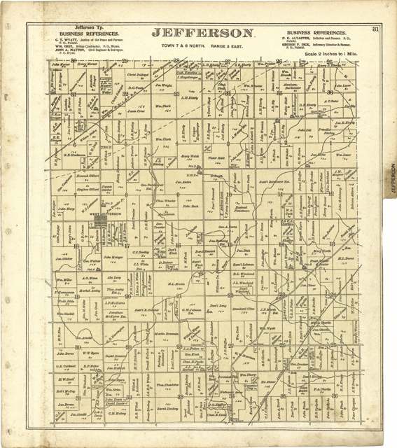
Photo: J. M. Lathrop and John C. Grim; Library of Congress, Geography and Map Division, public domain · Wikimedia Commons
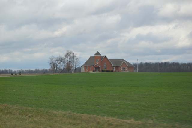
Photo: Nyttend, public domain · Wikimedia Commons
Local history sources: en.wikipedia.org · archive.org · archive.org · archive.org · ohioghosttowns.wordpress.com · en.wikipedia.org · en.wikipedia.org · commons.wikimedia.org · commons.wikimedia.org
Water
Groundwater wells (3 wells) The water here
- Montpelier Village32% of residentsGroundwater wells (4 wells)
- West Unity Village25% of residentsGroundwater wells (3 wells)
- Bryan City24% of residentsMichindoh (Maumee) Glacial Aquifer, groundwater wells
- Pioneer Village7% of residentsGroundwater wells (3 wells)
- Williams Co/hillside Country Living6% of residentsGroundwater wells (2 wells)
- Aqua Ohio - Seneca4% of residentsGroundwater wells (2 wells)
- Aqua Ohio - Norlick1% of residentsGroundwater wells (2 wells)
- Stryker Village1% of residentsGroundwater wells (2 wells)
- Brunersburg Wd - Evansport0% of residentsTiffin River (plus Brush Creek), stored in two reservoirs
- Oakwood MHP0% of residentsGroundwater wells (2 wells)
Hospitals, fire stations and more
Inside Jefferson Township, Williams County's boundary: 2 poor-rated bridges and 7 spill cases. Press a pin or a name for its whole record and its source.
Bridges rated poor (2)
-
Eberly Home Rd over I80 Ohio TpkPoor · built 1954
- Condition
- Poor: a deck, superstructure, substructure or culvert rated 4 or below on the 0 to 9 scale
- What it is
- Bridge
- Built
- 1954
- Length
- 58 ft
- Owner
- Other
- Vehicles a day
- 16,000
- Coordinates
- 41.60671, -84.47829
National Bridge Inventory (source) ↗ Street map and directions ↗
-
TR 141 (17.75) over Beaver CreekPoor · built 1997
- Condition
- Poor: a deck, superstructure, substructure or culvert rated 4 or below on the 0 to 9 scale
- What it is
- Bridge
- Built
- 1997
- Length
- 11 ft
- Owner
- County
- Vehicles a day
- 324
- Coordinates
- 41.58594, -84.48280
National Bridge Inventory (source) ↗ Street map and directions ↗
Source: FHWA National Bridge Inventory 2025. "Poor" means one major part rated 4 or below on the 0 to 9 scale; it calls for repair, not closing, unless the state posts or closes the bridge.
Spills reported since 2021 (7)
-
Manure Nos (Not Specified)2025-08-15 · Jefferson Twp
- Reported
- 2025-08-15
- What spilled
- Manure Nos (Not Specified)
- Where
- Jefferson Twp, Williams County
- Ohio EPA district office
- NWDO
- Ohio EPA case number
- 2508EPA0001374
Ohio EPA spill reports (source) ↗ Street map and directions ↗
-
Material Unknown2025-03-30 · Jefferson Twp
- Reported
- 2025-03-30
- What spilled
- Material Unknown
- Largest amount reported
- 250 gallons
- Where
- Jefferson Twp, Williams County
- Ohio EPA district office
- NWDO
- Ohio EPA case number
- 2503EPA0000463
Ohio EPA spill reports (source) ↗ Street map and directions ↗
-
Fuel Diesel / Diesel Fuel (Vehicle On Or Off Road)2022-04-25 · Jefferson Twp
- Reported
- 2022-04-25
- What spilled
- Fuel Diesel / Diesel Fuel (Vehicle On Or Off Road)
- Largest amount reported
- 100 gallons
- Where
- Jefferson Twp, Williams County
- Ohio EPA district office
- NWDO
- Ohio EPA case number
- 2204EPA0000575
Ohio EPA spill reports (source) ↗ Street map and directions ↗
-
Food Grade Product Solid2022-02-02 · Jefferson Twp
- Reported
- 2022-02-02
- What spilled
- Food Grade Product Solid
- Where
- Jefferson Twp, Williams County
- Ohio EPA district office
- NWDO
- Ohio EPA case number
- 2202EPA0000112
Ohio EPA spill reports (source) ↗ Street map and directions ↗
-
Other / All Other / Trade Name / Mixture / Solution Etc2021-10-30 · Jefferson Twp
- Reported
- 2021-10-30
- What spilled
- Other / All Other / Trade Name / Mixture / Solution Etc
- Where
- Jefferson Twp, Williams County
- Ohio EPA district office
- NWDO
- Ohio EPA case number
- 2110EPA0001682
Ohio EPA spill reports (source) ↗ Street map and directions ↗
-
Oil Petroleum Not Otherwise Specified (Nos)2021-06-25 · Jefferson Twp
- Reported
- 2021-06-25
- What spilled
- Oil Petroleum Not Otherwise Specified (Nos)
- Largest amount reported
- 250 gallons
- Where
- Jefferson Twp, Williams County
- Ohio EPA district office
- NWDO
- Ohio EPA case number
- 2106EPA0000928
Ohio EPA spill reports (source) ↗ Street map and directions ↗
-
Fuel Diesel / Diesel Fuel (Vehicle On Or Off Road)2021-01-20 · Jefferson Twp
- Reported
- 2021-01-20
- What spilled
- Fuel Diesel / Diesel Fuel (Vehicle On Or Off Road)
- Where
- Jefferson Twp, Williams County
- Ohio EPA district office
- NWDO
- Ohio EPA case number
- 2101EPA0000080
Ohio EPA spill reports (source) ↗ Street map and directions ↗
Source: Ohio EPA emergency response spill reports, 2021 to September 2026, one point per case where Ohio EPA placed it. A report is what the caller or responder recorded; amounts are often blank or estimated.
Its ZIP codes
Each ZIP code that touches Jefferson Township, Williams County, with the share of its residents who live here and the same headline figures as the ZIP page.
Local government
Who holds office in Jefferson Township, Williams County, how its elections and ballot issues came out, and the state auditor's record.
Who holds office
| Office | Name | Party | Term ends | Contact |
|---|---|---|---|---|
| Fiscal Officer | Linda M. Beck | 2028-03-31 | 17757 Co Rd I-50, West Unity 43570 | |
| Trustee | Scott C. Oberlin | 2027-12-31 | 18898 Co Rd H, Stryker 43557 | |
| Trustee | Austin Poynter | 2029-12-31 | 16260 Co Rd M, Pioneer 43554 | |
| Trustee | Brian Batterson | 2029-12-31 | 8011 Co Rd 18, Bryan 43506 |
Roster as of 2026-07-06: county board of elections.
Auditor of State record
- No fiscal caution, watch or emergency on the Auditor of State's lists.
- Agreed Upon Procedures, 2023 to 2024, released 2025-10-21
The county
Williams County: 10 ZIP codes, 22 cities, villages and townships, 38,264 people.
Nearby places
Quick answers
What county is Jefferson Township, Ohio in?
Jefferson Township, Williams County is a township in Williams County, Ohio, with 1,772 residents.
When was Jefferson Township, Ohio founded?
Jefferson Township, Williams County was settled 1833 (John Perkins, spring; Eli Oliver, fall); incorporated Erected 1837 (June 6 per the 1905 and 1920 county histories; March 6 per the 1882 history); first election July 2, 1837. Source
How did Jefferson Township, Ohio get its name?
Named for Thomas Jefferson, third President of the United States; one of twenty-four townships in Ohio sharing his name. Source
What ZIP code is Jefferson Township, Ohio?
Jefferson Township, Williams County is served by ZIP codes 43570, 43543, 43554 and 43506; 43570 holds the largest share of its residents.
Where does Jefferson Township, Ohio get its water?
The main water source for Jefferson Township, Williams County (Montpelier Village): Groundwater wells (3 wells).
Cite this page
Cite this page as:
Cracked Buckeye, "Jefferson Township, Williams County", https://crackedbuckeye.com/place/jefferson-township-williams-county/, built 2026-10-31, accessed [date].
How to cite · Report a correction · Built 2026-10-31
