Local events in West Unity
41 events in the next 90 days from 1 public calendar. All local events in West Unity
Checked October 20; the events page is refreshed daily.
Deep dives about West Unity
Long reads built from maps, newspapers and public records. All deep dives
How West Unity began
West Unity grew on land John Rings, a Westmoreland County, Pennsylvania, native, had entered in Brady Township in the mid-1830s; he laid out the town in 1842 and named it for Unity (Pleasant Unity) in his home county. Rings was also its first justice of the peace and first postmaster, and part owner of its first sawmill and gristmill. The Toledo plank road ran through the village from 1850, and by 1882 West Unity was the second-largest town in the county, with close to a thousand people, although no railroad reached it until the Cincinnati Northern came later. The village was incorporated in 1866. By 1920 it was known for egg packing: George W. Bond's plant shipped eggs gathered across the region under red, white and blue brands.
Settled 1834 or 1835 (John Miller's land entry near the village site; the 1882 and 1905 county histories give different years), platted 1842 (July 20, 1842, per the 1905 county history), incorporated 1866 (first village election February 24, 1866), by John Rings.
Where the name comes from
John Rings named the town for his birthplace. The 1882 county history gives this as Unity, Pennsylvania; the 1905 county history gives it as Pleasant Unity, a town in Rings's native Westmoreland County, Pennsylvania. Brady Township, where the village lies, was named at Gilbert Dunscomb's suggestion for Capt. Samuel Brady, a frontier scout.
Before the town
No Native village, trail or treaty site inside West Unity itself is recorded in the sources checked. For the surrounding Brady Township, the 1905 county history says the land was a favorite Native hunting ground for years after the cession, and that by general consent hunting parties were allowed to make annual visits. The same history records a group of mounds on the farm of Frederick Charles and a single mound on land once owned by James F. Smith, both in Brady Township. Some of the group were opened, and human remains and stone implements were found about two feet below the original surface; by 1905 plowing had leveled them all. It does not say which culture built them. The 1817 Treaty of the Maumee Rapids had already transferred Indian title to this part of northwestern Ohio to the United States.
- Mound group on the Frederick Charles farm (mound) — Brady Township, Williams County; exact location in relation to the village not given, prehistoric (culture not identified in the source) (archive.org)
- Solitary mound on the former James F. Smith land (mound) — Brady Township, Williams County, prehistoric (culture not identified in the source) (archive.org)
Timeline
- — John Miller enters land near the future site of West Unity in April. The 1882 county history dates this to 1834, and the 1905 history dates it to April 1835.
- — John Rings, born in Westmoreland County, Pennsylvania, in 1804, settles on the land that becomes the village, which was dense forest at the time.
- — On March 7, Brady Township is set off from Springfield Township. It is named at Gilbert Dunscomb's suggestion for Capt. Samuel Brady.
- — Walter Coleman builds the first gristmill in Brady Township. It runs on ox power.
- — West Unity is platted and a post office opens. The 1905 county history dates Rings's plat to July 20, 1842.
- — Rev. N. Crary of Hicksville is preaching to a Universalist congregation in West Unity, the first church organization in the town.
- — Citizens organize a Sons of Temperance society in the summer.
- — In April, W. A. Hunter begins a newspaper, the Equal Rights, which later becomes the Republican Standard and moves to Bryan in 1855.
- — In August, W. A. Hunter organizes a Masonic lodge at West Unity. The 1882 history calls it the first Masonic lodge in Williams County.
- — The plank road running west from Toledo is built through West Unity, and for years afterward settlers' covered wagons pass through daily on their way west.
- — Rev. A. L. Wood of Bryan organizes a Presbyterian congregation of about twenty members. They meet over Colberth and Rockwell's iron foundry.
- — The Union Agricultural Society of Williams, Fulton and Defiance Counties is organized at West Unity and holds its first three-day fair on Jacob Bohner's farm.
- — The Unity Mills open as a flouring mill and woolen factory.
- — West Unity is incorporated. At the election on February 24, H. H. Peppard is chosen mayor and C. W. Skinner clerk.
- — The Franklin Vigilance Horse Committee, a society for catching horse thieves, is organized among members from West Unity, Brady Township and part of Fulton County.
- — C. F. and J. W. Grisier start the Eagle newspaper. By 1905 it has become the Reporter.
- — The county history counts nearly a thousand people and calls West Unity the county's second-largest town, still without a railroad.
- — The First United Presbyterian Church is built at 201 E. North Street in the Gothic Revival style.
- — West Unity appears on sheet 9 of the Atlas of Williams County, Ohio, a 30-sheet landownership atlas.
- — The county history reports that a Detroit packer shipped more eggs from West Unity than from any other U.S. point except Petaluma, California.
- — The Bryan Times reports that the village is planning a sesquicentennial commemoration.
Stories
The Toledo War camp at the graveyard
The 1882 county history, in a chapter written by West Unity newspaperman C. F. Grisier, says the boundary quarrel with Michigan reached the future village. It says that in 1835 a squad of soldiers under Zachary Taylor camped on the ground later used for the West Unity graveyard, while the old Fulton line, the boundary Michigan claimed, ran about eight miles north of town. Congress settled the matter on June 15, 1836, by fixing the Harris line as the boundary, which kept the strip in Ohio. The chapter quotes an account from Howe's Historical Collections, which joked that Ohio stood on its dignity 'eight miles from the grounds of dispute.' No other source we checked confirms the Taylor encampment.
The Union fair on Jacob Bohner's farm
In 1857 the Union Agricultural Society of Williams, Fulton and Defiance Counties was organized at West Unity, with Dr. G. W. Finch as president. Bryan had held one fair already, and West Unity set out to outdo it. The fair ran for three days in late September on part of Jacob Bohner's farm. Admission was 10 cents, trotting entries came from Ohio, Michigan and Indiana, and the first premium was $50. Because of the war no fair was held in 1862. Bohner's agreement said the ground would return to him in any year the society failed to hold a fair, so in 1863 he refused further use of the land. The society did not find new grounds and came to an end.
Eggs under red, white and blue
By 1920 West Unity was a shipping point for eggs gathered across the surrounding country. George W. Bond ran stations in other towns and brought their eggs to his West Unity packing house, from which the Cincinnati Northern railroad carried them to Detroit. The 1920 county history credits him as the first man in the United States to pack quality eggs, sold under red, white and blue brands, and says a Detroit packer reported more eggs shipped from West Unity than from any U.S. point except Petaluma, California. Bond was a follower of Alexander Dowie of Zion City. For the twenty-nine years he ran the plant, the workday began with prayer, and Bible texts were painted on its walls.
Lockport, the town West Unity outgrew
Lockport, about four miles southeast of West Unity, was the first town platted in Brady Township. It had the township's first sawmill and first post office, with mail carried from Defiance. A. F. Hull opened its first store with goods brought from Maumee in 1835. Before roads were opened, settlers brought grain up the Tiffin River (Bean Creek) from Defiance in dugouts. The trip was eighty miles and took ten to twelve days, and the cargo was unloaded at Lockport. As West Unity grew, Lockport shrank, and both the 1905 and 1920 county histories compare it to Goldsmith's 'Deserted Village.'
Photographs
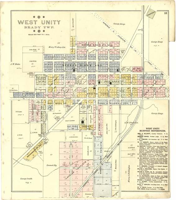
Photo: Library of Congress, Geography & Map Division, public domain · Wikimedia Commons
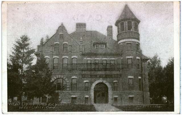
Photo: Columbus Metropolitan Library, via DPLA, public domain · Wikimedia Commons
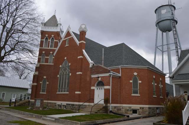
Photo: Nyttend, public domain · Wikimedia Commons
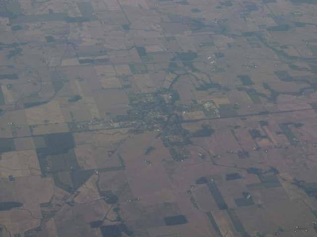
Photo: Ken Lund, CC BY-SA 2.0 · Wikimedia Commons
Local history sources: en.wikipedia.org · archive.org · archive.org · archive.org · en.wikipedia.org · commons.wikimedia.org · commons.wikimedia.org · commons.wikimedia.org · commons.wikimedia.org
Water
Groundwater wells (3 wells) The water here
- West Unity Village85% of residentsGroundwater wells (3 wells)
- Williams Co/hillside Country Living15% of residentsGroundwater wells (2 wells)
Hospitals, fire stations and more
Inside West Unity's boundary: 1 fire or EMS station, 2 public schools, 1 library, 1 police station, 4 public charging sites, 2 Toxics Release Inventory facilities and 8 spill cases. Press a pin or a name for its whole record and its source.
Fire and EMS stations (1)
-
Brady Township Fire DepartmentWest Unity
- Address
- 300 South Main Street, West Unity, OH 43570
- Coordinates
- 41.58107, -84.43471
USGS National Map structures (source) ↗ Street map and directions ↗
Source: USGS National Map structures (most Ohio records last updated 2019 to 2022), checked against the Columbus and Cleveland station lists. The department that answers a call is set by jurisdiction and mutual aid, not by distance.
Public schools (2)
-
Hilltop Elementary School3.5 of 5 stars · West Unity
- Address
- 1401 W Jackson St, West Unity, OH 43570
- School district
- Millcreek-West Unity Local School District
- Kind (NCES)
- Regular School
- Students, 2023-24
- 293
- Teachers (full-time equivalent)
- 18.62
- Report card, 2025-26
- 3.5 of 5 stars
- Performance index
- 82.2%
- Ohio building IRN
- 038901
- NCES school ID
- 390506304013
NCES school record ↗ Ohio School Report Card ↗ Street map and directions ↗
-
Hilltop High School3.5 of 5 stars · West Unity
- Address
- 1401 W Jackson St, West Unity, OH 43570
- School district
- Millcreek-West Unity Local School District
- Kind (NCES)
- Regular School
- Students, 2023-24
- 212
- Teachers (full-time equivalent)
- 20.75
- Report card, 2025-26
- 3.5 of 5 stars
- Performance index
- 75.3%
- Four-year graduation rate
- 93.3%
- Ohio building IRN
- 016436
- NCES school ID
- 390506304012
NCES school record ↗ Ohio School Report Card ↗ Street map and directions ↗
Source: NCES EDGE public school locations 2024-25 and Common Core of Data 2023-24 (type, students, teachers); Ohio School Report Cards 2025-26 (Department of Education and Workforce), matched by name within the district.
Public libraries (1)
-
West Unity Branch LibraryBranch · West Unity
- Address
- 109 S High, West Unity, OH 43570
- What it is
- Branch
- Library system
- Williams Co Public Library
- Open
- 2,392 hours a year, 52 weeks
- Building
- 2,542 sq ft
- System's visits, FY2024
- 130,000
- System's loans, FY2024
- 314,693
- People the system serves
- 31,533
- Phone
- (833) 633-7323
IMLS Public Libraries Survey (source) ↗ Street map and directions ↗
Source: IMLS Public Libraries Survey FY2024 (outlets and their systems). Any Ohio resident can get a free card at any Ohio public library.
Police stations (1)
-
West Unity Police DepartmentWest Unity
- Address
- 224 West Jackson Street, West Unity, OH 43570
- Coordinates
- 41.58675, -84.43644
USGS National Map structures (source) ↗ Street map and directions ↗
Source: USGS National Map structures, police stations, corrected and completed by hand (September 2026). The department that answers a call is set by jurisdiction, not by distance.
Public EV charging (4)
-
Indian Meadow Service Plaza (West Unity, OH) DC fast4 DC fast · West Unity
- Address
- 21738 CO RD M-50, West Unity, OH 43570
- Ports
- 4 DC fast
- Plugs
- CCS, CHAdeMO
- Network
- Electrify America
- Hours
- 24 hours daily
- Phone
- 833-632-2778
Station Locator (NREL) ↗ Alternative Fuels Data Center (source) ↗ Street map and directions ↗
-
Indian Meadow Service Plaza - Tesla Supercharger DC fast8 DC fast · West Unity
- Address
- 21738 Co Rd M-50, West Unity, OH 43570
- Ports
- 8 DC fast
- Plugs
- Tesla (NACS)
- Network
- Tesla
- Hours
- 24 hours daily. Please check Tesla's online station map to see if an adapter is required at this location.
- Phone
- 877-798-3752
Station Locator (NREL) ↗ Alternative Fuels Data Center (source) ↗ Street map and directions ↗
-
Tiffin River Service Plaza (West Unity, OH) DC fast4 DC fast · West Unity
- Address
- 21747 CO RD M-50, West Unity, OH 43570
- Ports
- 4 DC fast
- Plugs
- CCS, CHAdeMO
- Network
- Electrify America
- Hours
- 24 hours daily
- Phone
- 833-632-2778
Station Locator (NREL) ↗ Alternative Fuels Data Center (source) ↗ Street map and directions ↗
-
Tiffin River Service Plaza - Tesla Supercharger DC fast8 DC fast · West Unity
- Address
- 21747 Co Rd M, West Unity, OH 43570
- Ports
- 8 DC fast
- Plugs
- Tesla (NACS)
- Network
- Tesla
- Hours
- 24 hours daily. Please check Tesla's online station map to see if an adapter is required at this location.
- Phone
- 877-798-3752
Station Locator (NREL) ↗ Alternative Fuels Data Center (source) ↗ Street map and directions ↗
Source: NREL Alternative Fuels Data Center station list (May 2026), public and open stations, the posts at one address counted as one site.
Facilities reporting toxic releases (2)
-
Btr Sealing Systems West Unity PlantToxics Release Inventory · West Unity
- Address
- 214 Defiance St., West Unity, OH 43570
- County
- Williams County
- Status
- Reports to the Toxics Release Inventory (active)
- EPA program ID
- 43570BTRSL214DE
- EPA registry ID
- 110002109799
EPA facility record ↗ EPA Facility Registry Service (source) ↗ Street map and directions ↗
-
Trinity Specialty Compounding IncToxics Release Inventory · West Unity
- Address
- 600 Oak St, West Unity, OH 43570
- County
- Williams County
- Status
- Reports to the Toxics Release Inventory (active)
- EPA program ID
- 43570TRNTY6AKST
- EPA registry ID
- 110018893848
EPA facility record ↗ EPA Facility Registry Service (source) ↗ Street map and directions ↗
Source: EPA Facility Registry Service, Toxics Release Inventory reporters. Reporting a release is required of large users of listed chemicals; it is not by itself a violation.
Spills reported since 2021 (8)
-
Oil Hydraulic Fluid(S)2024-07-25 · Brady Twp
- Reported
- 2024-07-25
- What spilled
- Oil Hydraulic Fluid(S)
- Largest amount reported
- 5 gallons
- Where
- Brady Twp, Williams County
- Ohio EPA district office
- NWDO
- Ohio EPA case number
- 2407EPA0001273
Ohio EPA spill reports (source) ↗ Street map and directions ↗
-
Sodium Hydroxide (Naoh) / Caustic Soda / Lye2023-08-23 · Brady Twp
- Reported
- 2023-08-23
- What spilled
- Sodium Hydroxide (Naoh) / Caustic Soda / Lye
- Where
- Brady Twp, Williams County
- Ohio EPA district office
- NWDO
- Ohio EPA case number
- 2308EPA0001454
Ohio EPA spill reports (source) ↗ Street map and directions ↗
-
Oil Transformer Non Pcb2022-11-22 · West Unity
- Reported
- 2022-11-22
- What spilled
- Oil Transformer Non Pcb
- Largest amount reported
- 20 gallons
- Where
- West Unity, Williams County
- Ohio EPA district office
- NWDO
- Ohio EPA case number
- 2211EPA0001735
Ohio EPA spill reports (source) ↗ Street map and directions ↗
-
Fuel Diesel / Diesel Fuel (Vehicle On Or Off Road)2022-05-28 · Brady Twp
- Reported
- 2022-05-28
- What spilled
- Fuel Diesel / Diesel Fuel (Vehicle On Or Off Road)
- Largest amount reported
- 30 gallons
- Where
- Brady Twp, Williams County
- Ohio EPA district office
- NWDO
- Ohio EPA case number
- 2205EPA0000781
Ohio EPA spill reports (source) ↗ Street map and directions ↗
-
Oil Transformer Pcb2022-05-23 · West Unity
- Reported
- 2022-05-23
- What spilled
- Oil Transformer Pcb
- Largest amount reported
- 60 gallons
- Where
- West Unity, Williams County
- Ohio EPA district office
- NWDO
- Ohio EPA case number
- 2205EPA0000758
Ohio EPA spill reports (source) ↗ Street map and directions ↗
-
Fuel Gasoline ( 25% Ethanol Not E85)2022-05-02 · West Unity
- Reported
- 2022-05-02
- What spilled
- Fuel Gasoline ( 25% Ethanol Not E85)
- Largest amount reported
- 30 gallons
- Where
- West Unity, Williams County
- Ohio EPA district office
- NWDO
- Ohio EPA case number
- 2205EPA0000622
Ohio EPA spill reports (source) ↗ Street map and directions ↗
-
Fuel Diesel / Diesel Fuel (Vehicle On Or Off Road)2022-01-31 · West Unity
- Reported
- 2022-01-31
- What spilled
- Fuel Diesel / Diesel Fuel (Vehicle On Or Off Road)
- Largest amount reported
- 50 gallons
- Where
- West Unity, Williams County
- Ohio EPA district office
- NWDO
- Ohio EPA case number
- 2201EPA0000094
Ohio EPA spill reports (source) ↗ Street map and directions ↗
-
Fuel Diesel / Diesel Fuel (Vehicle On Or Off Road)2026-05-14 · Brady Twp
- Reported
- 2026-05-14
- What spilled
- Fuel Diesel / Diesel Fuel (Vehicle On Or Off Road)
- Where
- Brady Twp, Williams County
- Ohio EPA district office
- NWDO
- Ohio EPA case number
- 2605EPA0000808
Ohio EPA spill reports (source) ↗ Street map and directions ↗
Source: Ohio EPA emergency response spill reports, 2021 to September 2026, one point per case where Ohio EPA placed it. A report is what the caller or responder recorded; amounts are often blank or estimated.
Its ZIP codes
Each ZIP code that touches West Unity, with the share of its residents who live here and the same headline figures as the ZIP page.
| ZIP | Share | Water | Radon | Home value | Schools | Flood |
|---|---|---|---|---|---|---|
| 43570 West Unity | 56% | Groundwater wells (3 wells) | Too few radon tests | Median year built 1956 | Millcreek-West Unity Local · 3.5 stars overall | No digital FEMA flood map for this county |
Local government
Who holds office in West Unity, how its elections and ballot issues came out, and the state auditor's record.
Who holds office
| Office | Name | Party | Term ends | Contact |
|---|---|---|---|---|
| Fiscal Officer | Sarah Higdon | |||
| Member of Council | Terri M Lebowsky | 2029-12-31 | 401 E. Jackson St., Pob 561 | |
| Member of Council | Randy Mahlman | 2029-12-31 | 522 Linda Dr | |
| Member of Council | Stephen A. Marvin | 2029-12-31 | 210 N. Main St., Pob 136 | |
| Member of Council | Scott R. Dunson | 2029-12-31 | 812 E Church St. | |
| Member of Council | Kevin L. Gray | 2027-12-31 | 501 Linda Dr. | |
| Member of Council | Shawn Blaisdell | 2027-12-31 | 307 E. North St. | |
| Mayor | Don Leu | 2027-12-31 | 506 N. Liberty St. |
Roster as of 2026-07-06: county board of elections.
Auditor of State record
- No fiscal caution, watch or emergency on the Auditor of State's lists.
- Financial Audit, 2022 to 2023, released 2024-12-26
The county
Williams County: 10 ZIP codes, 22 cities, villages and townships, 38,264 people.
Nearby places
Rain and snow
How much has actually fallen on West Unity, day by day, from 1891 to now. Daily totals, not averages.
- rain, last 30 days
- 2.56 in
- 2026-09-30 to 2026-10-29
- rain so far in 2026
- 37.3 in
- 5.9 in above normal for the date
- snow so far in 2026
- 17.9 in
- a normal year brings 30.7 in
- a normal year
- 36.9 in
- average of 30 years, 1991-2020
| Month | Rain (in) | Snow (in) | Days counted |
|---|---|---|---|
| October 2026 | 2.56 | — | 29 |
| September 2026 | 4.31 | — | 30 |
| August 2026 | 5.87 | — | 31 |
| July 2026 | 3.57 | — | 31 |
| June 2026 | 3.27 | — | 30 |
| May 2026 | 1.66 | — | 31 |
| April 2026 | 8.81 | — | 30 |
| March 2026 | 5.38 | 0.1 | 31 |
| February 2026 | 0.69 | 4.8 | 28 |
| January 2026 | 1.21 | 12.9 | 31 |
| December 2025 | 1.80 | 6.5 | 31 |
| November 2025 | 2.09 | 8.1 | 30 |
| Wettest year | 2011 — 51.0 in |
|---|---|
| Driest year | 1963 — 22.9 in |
| Snowiest year | 2003 — 68.2 in |
| Wettest day on record | 25 August 1998 — 5.44 in |
| Heaviest snowfall in a day | 27 February 1900 — 12.21 in |
| Deepest snow on the ground | 9 February 1982 — 22.31 in |
Estimated, not measured. No rain gauge has ever stood inside West Unity, so every figure here is worked out from the gauges around it - the nearest ones weighted most. Treat them as close estimates rather than readings.
49,343 days of records, 1891-09-01 to 2026-10-29. Source: NOAA NCEI GHCN-Daily, 3,240 gauges in and around Ohio. A day is "gauged" when a gauge standing inside the boundary reported it, and the value is the mean of those gauges. Otherwise it is interpolated by inverse distance from every gauge reporting within 50 miles. Nothing is carried forward, back-filled or smoothed. Against NOAA nClimDiv county monthly precipitation over 136,848 complete county-months (checked 2026-10-31): correlation 0.9515, median absolute difference 0.217 in a month. Built 2026-10-31 from the Cracked Buckeye precipitation archive. Snow is the softer number — snowfall is measured by hand with a ruler, no agency publishes a gridded county snowfall series, and blowing snow defeats every observer.
Environmental permits and filings
What Ohio EPA has on file for West Unity: permits, inspections, violations, cleanups and the state loans behind sewer and water work. Every line links to the agency's own document.
- facilities and sites on file
- 12
- those placed on the map inside West Unity
| Program | Facilities and sites |
|---|---|
| Hazardous waste | 3 |
| Air pollution | 2 |
| Brownfield | 1 |
| Composting | 1 |
| Contaminated-site cleanup | 1 |
| Public drinking water | 1 |
| State sewer loans | 1 |
| State water loans | 1 |
| Wastewater and stormwater discharge | 1 |
| Date | Facility or site | What |
|---|---|---|
| WEST UNITY VILLAGE PWS | Public drinking water inspection | |
| WEST UNITY VILLAGE PWS | Public drinking water compliance letter | |
| WEST UNITY VILLAGE PWS | Public drinking water notice of violation | |
| WEST UNITY VILLAGE PWS | Public drinking water violation resolved | |
| WEST UNITY VILLAGE PWS | Public drinking water notice of violation | |
| WEST UNITY VILLAGE PWS | Public drinking water report | |
| VILLAGE OF WEST UNITY | Composting inspection | |
| WEST UNITY VILLAGE PWS | Public drinking water plan | |
| WEST UNITY VILLAGE PWS | Public drinking water inspection | |
| WEST UNITY VILLAGE PWS | Public drinking water inspection | |
| WEST UNITY VILLAGE PWS | Public drinking water report | |
| BDJ INDUSTRIES INC | Air pollution permit | |
| WEST UNITY VILLAGE PWS | Public drinking water notice of violation | |
| WEST UNITY VILLAGE PWS | Public drinking water notice of violation | |
| WEST UNITY VILLAGE PWS | Public drinking water notice of violation | |
| WEST UNITY VILLAGE PWS | Public drinking water inspection | |
| WEST UNITY VILLAGE PWS | Public drinking water warning letter | |
| WEST UNITY VILLAGE PWS | Public drinking water compliance letter | |
| VILLAGE OF WEST UNITY | Composting registration | |
| VILLAGE OF WEST UNITY | Composting inspection | |
| WEST UNITY VILLAGE PWS | Public drinking water violation resolved | |
| VILLAGE OF WEST UNITY | Composting registration | |
| WEST UNITY VILLAGE PWS | Public drinking water notice of violation | |
| UNITY MINI MART (SHAMROCK) | Wastewater and stormwater discharge permit | |
| UNITY MINI MART (SHAMROCK) | Wastewater and stormwater discharge permit |
Source: Ohio EPA eDocument portal (edocpub.epa.ohio.gov), indexed 2026-10-14. Facilities are placed on the map from Ohio EPA's own map layers, EPA's Facility Registry, coordinates written in the filings, or a geocoded street address. A permit filed under a private person's name (most are household septic systems) is counted but never named, placed or linked; licenses for individual workers and open-burning notices are left out entirely.
Quick answers
What county is West Unity, Ohio in?
West Unity is a village in Williams County, Ohio, with 1,763 residents.
When was West Unity, Ohio founded?
West Unity was settled 1834 or 1835 (John Miller's land entry near the village site; the 1882 and 1905 county histories give different years); laid out 1842 (July 20, 1842, per the 1905 county history); incorporated 1866 (first village election February 24, 1866). Founders on record: John Rings. Source
How did West Unity, Ohio get its name?
John Rings named the town for his birthplace. Source
What ZIP code is West Unity, Ohio?
Most of West Unity is in ZIP code 43570.
Where does West Unity, Ohio get its water?
The main water source for West Unity (West Unity Village): Groundwater wells (3 wells).
Cite this page
Cite this page as:
Cracked Buckeye, "West Unity, Williams County", https://crackedbuckeye.com/place/west-unity/, built 2026-10-31, accessed [date].
How to cite · Report a correction · Built 2026-10-31
