Water system
Montpelier Village
EPA ID OH8600912 · Williams County · 4,280 people served · owned by a local government
Montpelier Village treats its own water from Groundwater wells (4 wells).
The system's record
- Active wells
- 4
- Serves
- 4,280 people · Williams County
- EPA ID
- OH8600912
About this area's water
Did you know
- Montpelier's municipal tap water is reported to have won the Berkeley Springs International Water Tasting best municipal water award five times — 2003, 2006, 2007, 2017 and 2022. Source is Wikipedia only; the…
- The village was named directly after Montpelier, Vermont, when it was platted in 1845.
- For a village of 4,280 people, Montpelier runs an unusually large groundwater system: EPA records list nine wells feeding the plant, four clearwells and three elevated tanks, including one serving Holiday City.
Source: en.wikipedia.orgdata.epa.gov
History4
- 1845Montpelier platted and named after Montpelier, Vermont (a post office opened in 1846).
- 1875Village of Montpelier incorporated; today a charter village with a manager/council form of government that runs its own water, electric and sewer utilities.
- 2024EPA SDWIS records a health-based treatment-technique violation and a companion reporting violation for the village water system, both with compliance periods beginning 17 October 2024; both have…
- 2026An 'other'-category reporting-rule violation (the same violation type recorded against the system in 2006 and 2020, both resolved) opened on 7 January 2026 and remains open in EPA records.
Source: en.wikipedia.orgdata.epa.gov
Treatment & pressure
How it is treated
Groundwater system. EPA SDWIS lists nine village wells (Wells 1-9), a treatment plant (plus a retired 'Montpelier Village Old' plant record), four clearwells, elevated storage tanks on Bryant Road, Magna Drive and at Holiday City, a Travis Drive booster station, and high-service and backwash pumps.…
Source: data.epa.govdata.epa.gov
Water pressure
Not published. No pressure-zone or psi figures appear in any reachable village or Ohio EPA document.
What it costs
Not found. Montpelier's rate ordinance and utility billing pages are on the village website, which could not be reached this session; no rate figure should be published for this…
Water quality & impurities2
| Contaminant | Level | Limit | Year |
|---|---|---|---|
| Lead (90th percentile) Federal SDWIS lead 90th-percentile record for the 2025 monitoring period (4 ppb), well below the 15 ppb action level. | 0.004 mg/L | 0.015 (AL) | 2025 |
| Lead (90th percentile) The system's highest recorded 90th percentile in the 2014-2025 SDWIS series (13 ppb) — below but close to the 15 ppb… | 0.013 mg/L | 0.015 (AL) | 2023 |
Source: data.epa.govdata.epa.gov
EPA compliance record
Lead at the tap: 90th-percentile result 4 ppb in 2025 (action level 15 ppb).
EPA health-based violations since 2015:
- 2024Lead and Copper Rule (lead) · treatment technique violation · returned to compliance
4 violations of any kind logged since 2020, 3 of them paperwork (monitoring, reporting, public notice or consumer report).
Supply stress
Not established. No source reviewed this session indicates drought vulnerability, capacity limits or source contamination; equally, no Ohio EPA source-water assessment for the village was reachable, so absence of evidence is not evidence of absence.
Sewers
Sanitary
Village-operated. Montpelier provides central water, electric and sewer service to residents; the wastewater plant name, capacity and receiving stream are not documented in any reachable source.
Storm
Not documented in available sources.
Source: en.wikipedia.org
Sourcesverified
Compiled from the utility's own reports and public records, then independently re-checked against primary sources.
Main supplier in 1 ZIP code
Serves
Main water supplier in 1 ZIP code
- 43543 · Montpelier53% of residents
Population-weighted resident shares; a ZIP code can have more than one system on record. Recomputed from each ZIP's own system list, not from the map's cached footprint.
Buys from · Sells to
Montpelier Village does not buy water from another system on record; it treats its own source water.
No other system is on record buying water from Montpelier Village.
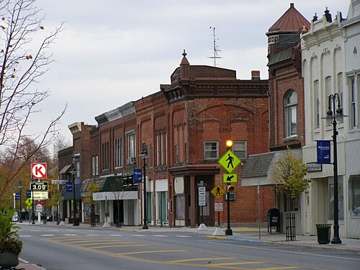
Photograph
On the map
Show this system's territory on the map — 1 ZIP code in all.
Sources
U.S. EPA SDWIS and Community Water System Service Area Boundaries (v3, 2026), Ohio EPA primacy data, 2020 census blocks: the system serving most residents, traced through purchases to the treating utility; Ohio EPA 2023 Sewer and Water Rate Survey (Ohio State, May 2025) for household bills; Ohio EPA DEFA loan awards since 2016 for the loans paragraph · EPA SDWIS · EPA service area boundaries · Ohio EPA drinking water · Ohio EPA rate survey
Notable facts: en.wikipedia.org, data.epa.gov
History: en.wikipedia.org, data.epa.gov
Water quality: data.epa.gov, data.epa.gov
Sewers: en.wikipedia.org
Treatment: data.epa.gov, data.epa.gov