Local events in Bratenahl
3 events in the next 90 days from 1 public calendar. All local events in Bratenahl
Checked October 20; the events page is refreshed daily.
How Bratenahl began
Bratenahl takes its name from Charles Bratenahl, a mid-19th-century farmer whose lakefront land gave its name to the road leading to it from St. Clair Avenue (now East 88th Street), though he was not the village's actual founder. In 1902 residents including Liberty E. Holden, Samuel Mather, and Frederick Goff, then mayor of Glenville, opposed Cleveland's annexation of Glenville and Collinwood and instead organized their own village, incorporated in 1903, one of Cleveland's older streetcar-era suburbs alongside Shaker Heights, Lakewood, and Cleveland Heights. Wealthy Cleveland families -- the Cornings, Hannas, Boltons, Mathers, Goffs, Ingalls, Haskells, Grassellis, Coits, and Cunninghams among them -- built lakefront mansions there, and the site of Charles Coit's old lakeshore summer hotel became first a country club in 1889, then the Lake Shore Country Club from 1908, and finally, after that building was razed in 1964, the brutalist high-rise Bratenahl Place condominiums, unveiled in 1967.
Incorporated 1903, from parts of Glenville and Collinwood, over resident opposition to Cleveland annexation, by Liberty E. Holden, Samuel Mather, and Frederick Goff (mayor of Glenville) led the 1902 opposition to annexation that produced the independent village.
Where the name comes from
The village is named for Charles Bratenahl, a mid-19th-century farmer who owned lakefront property in the area; the path to his farms from St. Clair Avenue was called Bratenahl Road (now East 88th Street), and the name carried over to the village. Wikipedia describes him as the village's 'founder,' but the Encyclopedia of Cleveland History presents him simply as the landowner the road and later the village were named for, not as an organizer of the 1903 incorporation.
Before the town
No source we reviewed identifies a specific, named Native American village, mound, or treaty site within present Bratenahl; the land was part of Glenville and Collinwood, along the Lake Erie shore, ceded to the United States by the 1795 Treaty of Greenville.
Nations recorded here: Lenape (Delaware), Wyandot.
Timeline
- — Farmer Charles Bratenahl owns lakefront property along what becomes Bratenahl Road (East 88th Street).
- — A country club opens on the former site of Charles Coit's lakeshore summer hotel, Coit House.
- — Liberty E. Holden, Samuel Mather, and Frederick Goff, mayor of Glenville, oppose Cleveland's planned annexation of Glenville and Collinwood.
- — Bratenahl incorporates as an independent village from parts of Glenville and Collinwood.
- — A new building at the country club site becomes the Lake Shore Country Club.
- — William G. Mather's lakefront estate, 'Gwynne,' designed by architect Charles Adams Platt, is documented in photographs.
- — The 1908 Lake Shore Country Club building is razed.
- — The brutalist luxury high-rise Bratenahl Place condominium complex opens on the former club site.
Stories
From a farmer's road to Cleveland's lakefront elite
Bratenahl carries the name of a mid-19th-century farmer, Charles Bratenahl, whose lakefront land gave its name to the road leading out to it -- but the village that eventually took his name was built by people considerably wealthier than he was. When Cleveland moved to annex Glenville and Collinwood in the early 1900s, Liberty E. Holden, Samuel Mather, and Glenville's own mayor Frederick Goff led local resistance, and the result, incorporated in 1903, became one of the city's most exclusive lakefront enclaves: the Cornings, Hannas, Boltons, Mathers, Goffs, Ingalls, Haskells, Grassellis, Coits, and Cunninghams all built mansions along the shore, including William G. Mather's Charles Adams Platt-designed estate 'Gwynne,' photographed in 1915. The old Coit House hotel site tracked the village's changing tastes across six decades -- a country club from 1889, the grander Lake Shore Country Club from 1908, and finally, after that building came down in 1964, the modernist Bratenahl Place high-rise condominiums that opened in 1967.
Photographs
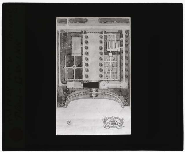
Photo: Frances Benjamin Johnston (attributed), Library of Congress Prints and Photographs Division, public domain · Wikimedia Commons
Local history sources: en.wikipedia.org · case.edu · commons.wikimedia.org · en.wikipedia.org
Historic places
2 places in Bratenahl on the National Register of Historic Places. Press a pin or a name for its whole record.
-
Gwinn EstateBuilding · Bratenahl · listed 1974
- Address
- 12407 Lake Shore Blvd.
- Where
- Bratenahl, Cuyahoga County · ZIP 44108
- What it is
- Building
- Listed on the National Register
- 1974
- NRIS reference number
- 74001430
- Coordinates
- 41.56018, -81.59921
National Register file (NPS) ↗ Search Wikipedia ↗ Street map and directions ↗ On the Cracked Buckeye map
-
Pickands, Jay M., HouseBuilding · Bratenahl · listed 1979
- Address
- 9619 Lake Shore Blvd
- Where
- Bratenahl, Cuyahoga County · ZIP 44108
- What it is
- Building
- Listed on the National Register
- 1979
- NRIS reference number
- 79001799
- Coordinates
- 41.54555, -81.62318
National Register file (NPS) ↗ Search Wikipedia ↗ Street map and directions ↗ On the Cracked Buckeye map
Source: National Park Service, National Register of Historic Places point file. The listing year is shown where NPS's certification date agrees with the listing's reference number. Listing recognizes significance; it does not restrict a private owner.
Water
Lake Erie, through a 10-foot tunnel running nearly 4 miles offshore from northeast Cleveland's lakefront The water here
- Cleveland Public Water System100% of residentsLake Erie
Hospitals, fire stations and more
Inside Bratenahl's boundary: 1 museum, 1 police station and 4 spill cases. Press a pin or a name for its whole record and its source.
Museums, historical societies, gardens and zoos (1)
-
Bratenahl Historical SocietyHistorical society · Bratenahl
- What it is
- Historical society
- City
- Bratenahl
- Coordinates
- 41.54631, -81.61697
Search Wikipedia ↗ IMLS Museum Data Files (source) ↗ Street map and directions ↗
The museum list is IMLS's 2018 file; a museum may have closed or moved since.
Source: IMLS Museum Data Files, 2018.
Police stations (1)
-
Bratenahl Police DepartmentBratenahl
- Address
- 411 Bratenahl Road, Bratenahl, OH 44108
- Coordinates
- 41.54654, -81.61545
Where this record comes from ↗ USGS National Map structures (source) ↗ Street map and directions ↗
Source: USGS National Map structures, police stations, corrected and completed by hand (September 2026). The department that answers a call is set by jurisdiction, not by distance.
Spills reported since 2021 (4)
-
Drum(S)2025-03-06 · Bratenahl
- Reported
- 2025-03-06
- What spilled
- Drum(S)
- Where
- Bratenahl, Cuyahoga County
- Ohio EPA district office
- NEDO
- Ohio EPA case number
- 2503EPA0000307
Ohio EPA spill reports (source) ↗ Street map and directions ↗
-
Material Gray Reached water2023-07-15 · Bratenahl
- Reported
- 2023-07-15
- What spilled
- Material Gray; Other / All Other / Trade Name / Mixture / Solution Etc; Sewage Sludge / Biosolids
- Reached a waterway
- Lake Erie
- Where
- Bratenahl, Cuyahoga County
- Ohio EPA district office
- NEDO
- Ohio EPA case number
- 2307EPA0001187
Ohio EPA spill reports (source) ↗ Street map and directions ↗
-
Oil Motor / Lube Oil / Vehicle2022-07-25 · Bratenahl
- Reported
- 2022-07-25
- What spilled
- Oil Motor / Lube Oil / Vehicle; Fuel Diesel / Diesel Fuel (Vehicle On Or Off Road)
- Largest amount reported
- 60 gallons
- Where
- Bratenahl, Cuyahoga County
- Ohio EPA district office
- NEDO
- Ohio EPA case number
- 2207EPA0001127
Ohio EPA spill reports (source) ↗ Street map and directions ↗
-
Fuel Oil/ Home Heating / Heating Oil Reached water2021-05-14 · Bratenahl
- Reported
- 2021-05-14
- What spilled
- Fuel Oil/ Home Heating / Heating Oil; Oil Petroleum Not Otherwise Specified (Nos)
- Largest amount reported
- 1,000 gallons
- Reached a waterway
- 18 - Ninemile Creek
- Where
- Bratenahl, Cuyahoga County
- Ohio EPA district office
- NEDO
- Ohio EPA case number
- 2105EPA0000674
Ohio EPA spill reports (source) ↗ Street map and directions ↗
Source: Ohio EPA emergency response spill reports, 2021 to September 2026, one point per case where Ohio EPA placed it. A report is what the caller or responder recorded; amounts are often blank or estimated.
Its ZIP codes
Each ZIP code that touches Bratenahl, with the share of its residents who live here and the same headline figures as the ZIP page.
Local government
Who holds office in Bratenahl, how its elections and ballot issues came out, and the state auditor's record.
Auditor of State record
- No fiscal caution, watch or emergency on the Auditor of State's lists.
- OP&F Examination, 2024, released 2026-04-21
The county
Cuyahoga County: 52 ZIP codes, 59 cities, villages and townships, 1,270,867 people.
Nearby places
Rain and snow
How much has actually fallen on Bratenahl, day by day, from 1871 to now. Daily totals, not averages.
- rain, last 30 days
- 1.73 in
- 2026-09-29 to 2026-10-28
- rain so far in 2026
- 33.0 in
- about normal for the date
- snow so far in 2026
- 40.0 in
- a normal year brings 67.3 in
- a normal year
- 38.8 in
- average of 30 years, 1991-2020
| Month | Rain (in) | Snow (in) | Days counted |
|---|---|---|---|
| October 2026 | 1.73 | — | 28 |
| September 2026 | 3.02 | — | 30 |
| August 2026 | 6.61 | — | 31 |
| July 2026 | 2.58 | — | 31 |
| June 2026 | 2.73 | — | 30 |
| May 2026 | 3.88 | — | 31 |
| April 2026 | 6.09 | 0.0 | 30 |
| March 2026 | 4.09 | 1.8 | 31 |
| February 2026 | 0.43 | 7.0 | 28 |
| January 2026 | 1.82 | 31.2 | 31 |
| December 2025 | 2.64 | 15.9 | 31 |
| November 2025 | 2.06 | 9.1 | 30 |
| Wettest year | 1996 — 54.7 in |
|---|---|
| Driest year | 1963 — 20.1 in |
| Snowiest year | 1996 — 106.1 in |
| Wettest day on record | 1 September 1901 — 3.72 in |
| Heaviest snowfall in a day | 25 December 2020 — 12.40 in |
| Deepest snow on the ground | 14 November 1996 — 20.82 in |
Estimated, not measured. No rain gauge has ever stood inside Bratenahl, so every figure here is worked out from the gauges around it - the nearest ones weighted most. Treat them as close estimates rather than readings.
56,914 days of records, 1871-01-01 to 2026-10-28. Source: NOAA NCEI GHCN-Daily, 3,240 gauges in and around Ohio. A day is "gauged" when a gauge standing inside the boundary reported it, and the value is the mean of those gauges. Otherwise it is interpolated by inverse distance from every gauge reporting within 50 miles. Nothing is carried forward, back-filled or smoothed. Against NOAA nClimDiv county monthly precipitation over 136,848 complete county-months (checked 2026-10-31): correlation 0.9515, median absolute difference 0.217 in a month. Built 2026-10-31 from the Cracked Buckeye precipitation archive. Snow is the softer number — snowfall is measured by hand with a ruler, no agency publishes a gridded county snowfall series, and blowing snow defeats every observer.
Environmental permits and filings
What Ohio EPA has on file for Bratenahl: permits, inspections, violations, cleanups and the state loans behind sewer and water work. Every line links to the agency's own document.
- facilities and sites on file
- 9
- those placed on the map inside Bratenahl
| Program | Facilities and sites |
|---|---|
| Wetland and stream fill | 5 |
| Sewer and water-line construction | 2 |
| Hazardous waste | 1 |
| Wastewater and stormwater discharge | 1 |
| Date | Facility or site | What |
|---|---|---|
| TWO BRATENAHL PLACE | Wastewater and stormwater discharge permit | |
| 100 BRATENAHL ROAD TRUST PROJECT | Wetland and stream fill permit | |
| 100 BRATENAHL ROAD TRUST PROJECT | Wetland and stream fill permit | |
| NEWPORT HARBOR EXTENSION USACE LRB-1992-04735 | Wetland and stream fill permit | |
| NEWPORT HARBOR EXTENSION USACE LRB-1992-04735 | Wetland and stream fill permit | |
| PCN COORDINATION 100 BRATENAHL RD TRUST REVETMENT | Wetland and stream fill permit | |
| DAYGLO COLOR CORP | Sewer and water-line construction permit | |
| SIFCO FORGE GROUP | Sewer and water-line construction permit | |
| NEWPORT HARBOR EXTENSION USACE LRB-1992-04735 | Wetland and stream fill permit | |
| NEWPORT HARBOR EXTENSION USACE LRB-1992-04735 | Wetland and stream fill permit | |
| NEWPORT HARBOR EXTENSION USACE LRB-1992-04735 | Wetland and stream fill permit | |
| NEWPORT HARBOR EXTENSION USACE LRB-1992-04735 | Wetland and stream fill permit | |
| MYEROFF PROJECT USACE LRB-2024-00461 | Wetland and stream fill permit | |
| NEWPORT HARBOR EXTENSION USACE LRB-1992-04735 | Wetland and stream fill permit | |
| DAYGLO COLOR CORP | Sewer and water-line construction permit | |
| TWO BRATENAHL PLACE | Wastewater and stormwater discharge inspection | |
| TWO BRATENAHL PLACE | Wastewater and stormwater discharge inspection | |
| TWO BRATENAHL PLACE | Wastewater and stormwater discharge compliance letter | |
| SIGNLITE CORPORATION | Hazardous waste notice of violation | |
| SIGNLITE CORPORATION | Hazardous waste cleanup response |
Source: Ohio EPA eDocument portal (edocpub.epa.ohio.gov), indexed 2026-10-14. Facilities are placed on the map from Ohio EPA's own map layers, EPA's Facility Registry, coordinates written in the filings, or a geocoded street address. A permit filed under a private person's name (most are household septic systems) is counted but never named, placed or linked; licenses for individual workers and open-burning notices are left out entirely.
Quick answers
What county is Bratenahl, Ohio in?
Bratenahl is a village in Cuyahoga County, Ohio, with 1,430 residents.
When was Bratenahl, Ohio founded?
Bratenahl was incorporated 1903, from parts of Glenville and Collinwood, over resident opposition to Cleveland annexation. Founders on record: Liberty E. Holden, Samuel Mather, and Frederick Goff (mayor of Glenville) led the 1902 opposition to annexation that produced the independent village. Source
How did Bratenahl, Ohio get its name?
The village is named for Charles Bratenahl, a mid-19th-century farmer who owned lakefront property in the area; the path to his farms from St. Source
What ZIP code is Bratenahl, Ohio?
Most of Bratenahl is in ZIP code 44108.
Where does Bratenahl, Ohio get its water?
The main water source for Bratenahl (Cleveland Public Water System): Lake Erie, through a 10-foot tunnel running nearly 4 miles offshore from northeast Cleveland's lakefront.
Cite this page
Cite this page as:
Cracked Buckeye, "Bratenahl, Cuyahoga County", https://crackedbuckeye.com/place/bratenahl/, built 2026-10-31, accessed [date].
How to cite · Report a correction · Built 2026-10-31
